The lost Inca temple of of Ausangate.

Status
Not open for further replies.

Crow

Silver Member
Jan 28, 2005
3,325
9,293
In a tax haven some where
Detector(s) used
ONES THAT GO BEEP! :-)
Primary Interest:
Other
Gidday Amigos

I just watched a documentary called the lost The lost Inca temple of of Ausangate.

The Inca Empire was a beacon of civilization in the Andes Mountains of South America. Its people had a spiritual relationship to the landscape, worshiping mountains and lakes as gods. After the empire collapsed, its legacy survived in the rarified air of the high mountains.

Prolific archeologist Johan Reinhard searched high and low to solve the mysteries of this lost empire. Among his greatest accomplishments was the recovery of three perfectly preserved mummies from the highest archeological site in the world.

But one of the Inca's most important temples evaded him: the lost temple of Ausangate.

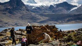
In 2011, environmental scientist Preston Sowell discovered ruins and artifacts submerged in Lake Sibinacocha, sixteen thousand feet above sea level, at the headwaters of the Amazon River in Peru.

Sowell believes that the ruins within and around the lake could be part of Reinhard's lost temple, one of the Inca’s most significant ceremonial sites. Subsequently, two high-altitude scuba divers on Sowell’s team went deeper into the lake to explore further, and one was tragically killed. In the wake of this tragedy, Sowell developed a profound obligation to understand and protect the site and its fragile ecosystem.

Despite the high altitude and harsh conditions, Sowell has found wildlife thriving at Lake Sibinacocha, some well above previously known altitudes. In 2017, he even documented the Andean mountain cat in the watershed, the rarest and most endangered cat in the Americas. Sadly, Sibinacocha and its wildlife are under threat from mineral exploitation.

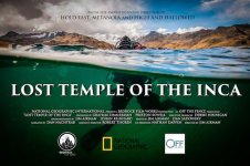
Lost Temple of the Inca, directed by Jim Aikman, follows Sowell's work with a team of archaeologists attempting to reveal the significance of the site, and his personal quest to protect this sacred place and understand the profound impact it has had on his life.

That was the sell ....of the documentary created for national geographic and Disney

While I found the topic interesting the presentation was extremely poor with Confirmation Bias with climate based agenda.

Many of the conclusions was outright assumptions and would be an embarrassment to the scientific community. Some of their conclusions was so poor they could be almost said it was environmental protection propaganda.

What has happened to quality research?
LostTempleofInca540.jpg

Crow
 

OP
OP
Crow

Crow

Silver Member
Jan 28, 2005
3,325
9,293
In a tax haven some where
Detector(s) used
ONES THAT GO BEEP! :-)
Primary Interest:
Other
Well Amigos

I am the first to call out the mining industries dirty practices and I do believe sites should be protected historical or environmental reason that is not the issue. My issue is Confirmation Bias with the program.

First claim title below from their scientific paper.

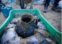
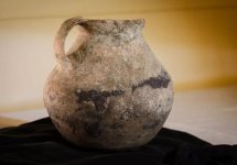
A pre Inca pot from underwater ruins discovered in an Andean Lake provides sedimentary record of marked Hydro logical change due to climate change?

1.JPG

3.JPG

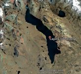
What they infer that the lake hydrology has changed because of melting ice because of climate has made the lake bigger. But infact what they fail to mention the Peruvian government placed a dam wall on the lakes entrance raising the water level of the lake. So the lake size never increased due to global warming. here is a picture of the lake in question.

lake one.JPG

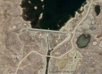
Lake Sibinacocha the lake in question has a roughly 18 metre dam wall thus rising the water lever . The pot was found in 3 metres of water 150 metres from shore so the lake before the dam as you can see below would of been 18 metres lower thus the pot found in 3 metre deep water was on dry land. Not from flooding from melting ice but a dam you can clearly see below.

lake two dam.JPG

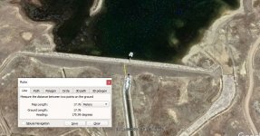
you can see rough measurement of dam wall below.

lake 3 dam wall raised about 18 metres.JPG

4.JPG

So the claims the pot was in part of an underwater temple was incorrect because until the dam was made it would of been on dry land.

The scientific paper will not give the exact position of where the pot was found but in the documentary it was less than 50 metres from shore. The original shore in their own image is 150 metres from the present day shore.

But there is more.....

Crow
 

Last edited:
OP
OP
Crow

Crow

Silver Member
Jan 28, 2005
3,325
9,293
In a tax haven some where
Detector(s) used
ONES THAT GO BEEP! :-)
Primary Interest:
Other
Another factor of documentary they state it is a very remote place. That is not the case you can actually drive up to the lake itself up the dam wall. The area from the dam wall was only 2km away.

So not quite the remote place they made out to be.

Then the documentary did some thing entirely annoying is show a mine open cut in Chile and the stated that the lake and area around the lake was was in the sights of mining companies to explore for minerals. It was not the case there was mining activity 200 km away on the over side of the mountain. And then they claimed it was their efforts to get the site protected.

It already was as its dam catchment supplying water to half a million people.

Then finally the claims they may of found an Inca temple. Artifacts found are not conclusive as many areas i have seen offerings to Pacamana earth goddess all over Peru and Bolivar. The ruins was low dwelling perhaps for high country herders not high status temple as claimed.

293726.1024x576.jpg

On the expedition of experts there was no geologist the serpentine formation underwater looked more like geological debris from past glacial action.

Then in their report dated sediment deposits with in pot was examined and claimed it was in the lake since the 17th century. This would of been post collapse Inca empire and further the pot could of came from elsewhere so not conclusive.

In sample of lead level there was a higher rate of lead exposure from the 1960's atomic testing that might indicated the pot was not underwater as claimed

So we had some very inconclusive results but it seems information was cherry picked by the documentary producer to suit their political and environmental agenda and ignore all other data. Conclusion both the archeologists and environmental scientist used confirmation bias in their research.

This is an example how far the documentary film industry has fallen so low.

Crow
 

Dec 14, 2023
1
4
Firstly, I am NOT a treasure hunter (though there is some fascinating information on this site!). I am only commenting on this site because it was recently brought to my attention that the OP had posted a rather negative series of comments about a documentary on one of my projects. Though I think that it’s normally best to ignore such feedback (folks are entitled to their opinions), after reading the OP’s comments, it became clear that their post was most likely made for malicious reasons. They use a serious of points that are at best deceptive and at worst simply false in order to mislead the reader. Some of this could potentially be misunderstandings/misinterpretations by the OP as they are clearly not a native English speaker, but deliberately ignoring information while providing their own, misleading 'research', indicates that their criticisms go beyond misunderstanding. I can only speculate for what end, but I can see why they use a pseudonym.

I will address the highlights below, but that should provide readers and moderators with enough information to conclude that the OP is not speaking with integrity.

The OP’s quoted text and my responses (see bullets) are included as follows:

“Many of the conclusions was outright assumptions and would be an embarrassment to the scientific community. Some of their conclusions was so poor they could be almost said it was environmental protection propaganda.”
  • Response: The second sentence in this statement may provide a hint at the OP’s motivation for using such disinformation to try and discredit our work.
“First claim title below from their scientific paper. …What they infer that the lake hydrology has changed because of melting ice because of climate has made the lake bigger. But infact what they fail to mention the Peruvian government placed a dam wall on the lakes entrance raising the water level of the lake. So the lake size never increased due to global warming. here is a picture of the lake in question. … So the claims the pot was in part of an underwater temple was incorrect because until the dam was made it would of been on dry land.”
  • Response: This was actually addressed in both the documentary and in Michellutti et al. (2019), which the OP clearly read as they cite from it in their comments without actually referencing the paper, which suspiciously makes it impossible for the reader to fact-check the OP. That paper, Michellutti et al. (2019), states on p. 7 that, “In 1996, a dam was constructed at the outflow of Laguna Sibinacocha in order to ensure adequate water supply for downstream populations. …Aerial photographs of the lake taken in 1931 show that the underwater ruins, including the serpentine rock structure, were submerged prior to the construction of the dam.”
“Lake Sibinacocha the lake in question has a roughly 18 metre dam wall thus rising the water lever . The pot was found in 3 metres of water 150 metres from shore so the lake before the dam as you can see below would of been 18 metres lower thus the pot found in 3 metre deep water was on dry land. Not from flooding from melting ice but a dam you can clearly see below.”
  • Response: To support this conclusion, the OP includes a figure from Google Earth in which they are measuring distance as though it was height. Even if they could measure the height of the dam from Google Earth, the digital elevation models (DEMs) used for that part of the world are based on Space Shuttle DEM data, which only have a 90 meter resolution… Furthermore, no dam height translates to corresponding water rise. However, publicly available data, which are cited in Michellutti et al. (2019; the paper that the OP claims to have read) demonstrate that the dam only increased the water level by ~2 meters. The submerged structures are ~3 meters below the water at the dam's low water levels and 4+ meters at high water levels.
“Another factor of documentary they state it is a very remote place. That is not the case you can actually drive up to the lake itself up the dam wall. The area from the dam wall was only 2km away.”
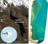
  • Response: Indeed, you can drive to the dam at the south end of the 18km long lake (nowhere near the field site), after a drive of 6 hours depending on the weather conditions. Horses are still required to get to the site. Perhaps the OP’s definition of “remote” is different than ours? However, the statement that the dam is only 2km away from the dive site is false. That is clearly refuted in the figure from Michellutti et al. (2019), which the OP actually includes in their comments without citation. That figure shows a scale bar that the OP must have missed or misread.
“Then the documentary did some thing entirely annoying is show a mine open cut in Chile and the stated that the lake and area around the lake was was in the sights of mining companies to explore for minerals. It was not the case there was mining activity 200 km away on the over side of the mountain. And then they claimed it was their efforts to get the site protected.”
  • Response: This is another piece of misinformation from the OP. There were actually illegal mining operations within the watershed that the local community burned down a few years ago. Furthermore, there were and are mining concessions granted throughout the lake’s watershed, including over some of the glaciers. This is of course publicly available information, had OP taken the time to look.
“Then finally the claims they may of found an Inca temple. Artifacts found are not conclusive as many areas i have seen offerings to Pacamana earth goddess all over Peru and Bolivar. The ruins was low dwelling perhaps for high country herders not high status temple as claimed.”
  • Response: There were no claims in the documentary that the site was the Inca temple in question, only speculation. Much work remains to be done to draw such conclusions. The OP further claims to understand what offerings to “Pacamana” [Pachamama] are (which is not relative to the temple in question anyway) and what ceremonial structures vs “country herders” dwellings look like, without offering any background for their apparent expertise in the field, besides a misspelling for Bolivia…
“On the expedition of experts there was no geologist the serpentine formation underwater looked more like geological debris from past glacial action.”
  • Response: How would you know what experts have been in the field with us? Regardless, this has been vetted by geomorphologists and is clear to any researcher visiting the site. Again, the OP offers no citation or their expertise/background for making such a statement.
“Then in their report dated sediment deposits with in pot was examined and claimed it was in the lake since the 17th century. This would of been post collapse Inca empire and further the pot could of came from elsewhere so not conclusive.”
  • Response: This is more or less what the sediment data from the pot indicate; however, Michellutti et al. (2019) does offer potential explanations for the discrepancy, which the OP ignores.
“In sample of lead level there was a higher rate of lead exposure from the 1960's atomic testing that might indicated the pot was not underwater as claimed”
  • Response: This statement makes no sense and seems to provide more misinformation and further elucidates the OP’s willingness to draw conclusions for which they themselves seem to have no background to support. What Michellutti et al. (2019) does conclude is that, “The basal pot date indicates that the wet phase of the early LIA [little ice age] raised water levels in Laguna Sibinacocha and eventually inundated the study pot and surrounding archaeological features beginning in the early- 1600s CE. Although precipitation declined after 1680 CE, cool temperatures during the LIA would have mitigated evaporation from the lake’s surface and kept water levels elevated. This is supported by an undisturbed 210Pb profile and fossil diatom data indicating water levels remained high above the pot since its inundation.”
“So we had some very inconclusive results but it seems information was cherry picked by the documentary producer to suit their political and environmental agenda and ignore all other data. Conclusion both the archeologists and environmental scientist used confirmation bias in their research.”
  • Response: This statement may provide further insight into the OP’s true intentions and biases related to politics and environmentalism. Regarding the second sentence, the OP may want to reconsider the bases for their own conclusions and biases before leveling such accusations on a third-party…
Moderators, also note that the OP uses several figures and photographs in their comments that they have no copyright permission for and which they posted without citation.

Preston Sowell

Reference:

Michelutti, Neal et al. 2019. A pre-Inca pot from underwater ruins discovered in an Andean lake provides a sedimentary record of marked hydrological change. Nature Scientific Reports. 9, Article number: 19193.
 

Treasure_Hunter

Administrator
Staff member
Jul 27, 2006
48,458
54,902
Florida
Detector(s) used
Minelab_Equinox_ 800 Minelab_CTX-3030 Minelab_Excal_1000 Minelab_Sovereign_GT Minelab_Safari Minelab_ETrac Whites_Beach_Hunter_ID Fisher_1235_X
Primary Interest:
All Treasure Hunting
Thread is over 2 years old.
 

Status
Not open for further replies.

Top Member Reactions

Users who are viewing this thread

Top