Reconsidering Texas in 1830s

research guy

Jr. Member
Apr 8, 2019
60
111
PA
Primary Interest:
Other
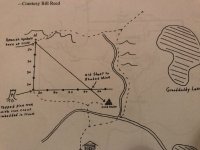
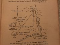
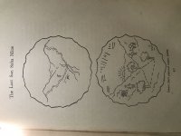
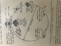
Concerning the San Saba mine. I'm not claiming to be any kind of expert here on the San Saba mine, but there are some things I've found that I would like to address. I have a first edition "Coronado's Children" by J. Frank Dobie, 1931. In this book the first 61 pages are dedicated to the San Saba mine. On page 55 we find a map. When I first saw this map, I immediately recognized it as being very similar to another map I've seen in Borens "the gold of Carre-Shinob" page 196. Obviously there is some striking resemblances between these two maps.

According to Boren, the Macginnis map was drawn by Elzy Lay, aka Bill Macginnis, and given to the governor of New Mexico to secure his own release from the New Mexico penitentiary.

For obvious reasons, the Macginnis map should be considered suspect. It was his golden ticket out of prison, and the proposed location of where he claimed it to be was States away from Texas. Or was it?

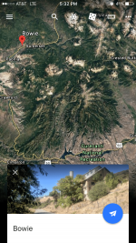
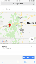
This Bowie story takes place in 1832ish. The one thing I know about treasure hunters is that they tend to give you lots of truthful information, but they leave out the useful information that you would require to do anything with it.

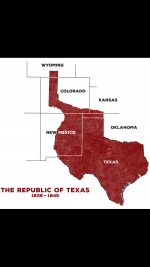
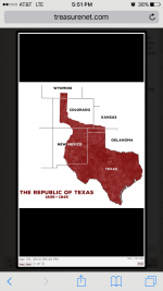
Now I'm not an expert on the San Saba mine, but one thing I do know for sure, is that Texas hasn't always been the Texas you tend to think of when looking at a map, particularity when you are discussing the 1830s. This is kinda the same problem you get into when it is said that cibola is in New Mexico. New Mexico didn't exists in coronados time, but new Spain did.

Part of New Spain eventually became New Mexico, and Texas was also part of New Spain . One thing that can be deduced from both of these maps and the information provided from them, is that both Utah and Texas at one time were both considered New Spain. Something that may need be considered is what Texas looked like in 1830s, when Bowie went looking for it. All of the sudden, Texas isn't so far away from what would eventually be called Utah.

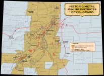
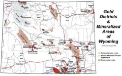
I'm not into conspiracy theories, and some would consider what I'm suggesting exactly that. Bowie was hunting treasure. Elzy Lay was part of the Cassidy/Sundance gang. All things being equal, is it possible that San Saba mine was located both in Texas and near Utah in the 1830s? If either of these men were truly telling the whole truth, would we currently be still looking for the San Saba mine? I seem to remember that Colorado had a pretty massive silver mine in its own rights, and you could get there going south from Wyoming. Was Elzy lay mistaken or purposefully misleading about his information?

I'm not claiming to be right on any of the things I'm discussing above. I do believe that it's worth considering. And maybe it will give someone a new direction to address this lost mine. Texas wasn't always the Texas you tend to think of, particularity in Bowies time.

Food for thought!
 

Attachments

  • IMG_1193.JPG
    IMG_1193.JPG
    1.2 MB · Views: 465
  • IMG_1194.JPG
    IMG_1194.JPG
    1 MB · Views: 391
  • IMG_1195.PNG
    IMG_1195.PNG
    121.3 KB · Views: 384
OP
OP
R

research guy

Jr. Member
Apr 8, 2019
60
111
PA
Primary Interest:
Other
Yes, I believe it is very interesting. This is what I find most interesting about treasure hunting. These hand drawn maps offer different stories, but share many similarities in the way of landmarks and features. there is absolutely zero reason that these two seperate maps can't be representing the exact same place. Supposedly, one map is representative of the 1830s and the other from after 1900s. But if we seperate them and evaluate the Elzy lay map independently on it own merit, we can potentially gain further useful information.

The first elephant in the room is that clearly Elzy lay has either seen the location that represents the San Saba map, or he has physically used the San Saba map as the basis for his own map. I don't think this is disputable. He either knows where the location is, or he plagurized the San Saba map. Either way, the two maps represent the same place if you ask me.

The second elephant in the room as far as I'm concerned, is with Boren. We as his readers only get to see the facsimile map that he wanted us to see. This is a problem as far as I'm concerned, with people that print map facsimiles in their own books. I have evidence to show that authors either accidently neglect important information and markers from the original map when creating their facsimiles to print, or they are neglecting important information on purpose. In the case of Boren and this map he printed, there is a glaring inconsistency between his map and the San Saba map. It's the inclusion of granddaddy lake in his facsimile. I believe Boren put this in his map to be misleading and place it in the vicinity of Utah, for no other reason than his own purposes and motives. Clearly it isn't represented in the San Saba map.

I'm curious if anyone on Tnet has access to a copy of the original Elzy lay map that Boren represented.

I've never seen anyone stand up for Boren on this website, and I'm not sure how others feel about the information he offers, but I believe his information is tainted and potentially misleading. If someone has additional sourcing or maps that they could present in this thread, would be greatly appreciated.
 

OP
OP
R

research guy

Jr. Member
Apr 8, 2019
60
111
PA
Primary Interest:
Other
Does it match "Gold Veins" in Wyoming, Colorado, Kansas, New Mexico, Oklahoma, & Texas...?


I don't know about Wyoming, Kansas, New Mexico, Oklahoma or Texas, but the historic mining district of Colorado seems to line up well with my theory.
 

Attachments

  • IMG_1256.JPG
    IMG_1256.JPG
    2.1 MB · Views: 305
OP
OP
R

research guy

Jr. Member
Apr 8, 2019
60
111
PA
Primary Interest:
Other
Wyoming matches up pretty good as well. Elzy Lay stated that you would approach the mine from Wyoming moving south. So the geological evidence and historical mine data adds up in the right direction for the theory. That's the point of his thread.... Jim Bowles timeline puts the San Saba in the 1830s, and in the mid 1830s (the republic of) texas included this particular section of Colorado, that I'm theorizing about. The evidence, timeline, and information seem good for the theory to be plausible. I'm willing to listen too and consider any objections or dessentions to what I'm proposing in my theory. Lots of people have read this thread, but only you and I have commented on this.
 

Attachments

  • IMG_1257.JPG
    IMG_1257.JPG
    80.8 KB · Views: 299

Oroblanco

Gold Member
Jan 21, 2005
7,837
9,826
DAKOTA TERRITORY
Detector(s) used
Tesoro Lobo Supertraq, (95%) Garrett Scorpion (5%)
It is a most interesting new approach to a famous lost mine, don't think that you don't have the attention of many other people (like me). Please do continue...

:coffee2: :coffee: :coffee2: :coffee2:
 

OP
OP
R

research guy

Jr. Member
Apr 8, 2019
60
111
PA
Primary Interest:
Other
I have to get more documentation (illustrations) from the Coronado children book, and I'll post again shortly. I'm not where the Book is right now.
 

OP
OP
R

research guy

Jr. Member
Apr 8, 2019
60
111
PA
Primary Interest:
Other
So it occurred to me that before we move forward, it would probably be expedient to understand the maps we've already looked at and extract the information that we can from them. The object of examining the maps is to extract the objective information and identify the potentially useful subjective information.

From my experience, it needs to be understood that these maps that we are currently looking at would be considered maps of a "general area". Until I get additional evidence of where Boren copied his map from, or can view his source map for myself, I am considering his hand-drawn map suspect, meaning less trustworthy than that of the map from "Coronado's children", and the reason for this is the information he seems to have overtly left out for his reader. Basic information that is presented in the "Coronado's children" map, is missing from borens map, for example: units of measurements, general distances from, physical names of features, the fact that the measurement legend is backwards from one to the other, and the fact that borens map looks like it was drawn on a bar napkin.

For those unfamiliar with these types of measurements used in this Coronado's children map, the unit "V" is a Vera. 30 Vera is closely measured to 30 meters, or roughly 100 feet. The other unit of measure being used is the "league". This is important to understand when traveling through the mountains.

In this map it states that it is one league from the fork in the river to the first broken metate. The concept is that you are traveling at walking speed it takes 1 hour to get from the fork in the river to the metate itself. But it's important to understand that traveling from the 1st broken metate back to the fork in the river most likely won't be 1 hour in the mountains. It will most likely be a longer or shorter length of time depending on ascending or descending the mountain.

Using simple geological principles that water flows down hill, and smaller streams flow into larger streams it would appear that silver creek flows south, and therefore to walk from the fork in the stream, up hill to the first broken metate, it takes 1 hour, but the trip back may only take 30-45 minutes. So effectively, generally speaking leagues average 2 1/2 miles per hour depending on terrain. So, it's reasonable to speculate that traveling to the metate up hill, it might actually be 1 1/2 to 2 miles in reality.

We may not be able to determine for sure that the feature named "San Saba river" flows east or west, but we can determine for 99% sure that the "silver creek" does in fact flow into the "San Saba river" and the current is southward downhill. Very, very few rivers flow down stream, and then split into two seperate rivers. It's very rare, but not impossible. Rivers that actually do this, generally don't do it for many years. They tend to meander to one side over time and then favor that route, until eventually one leg gets completely cut off by the meandering.

Another feature that sticks out like a sore thumb, is the tree reference. Boren states that it is a topped pine tree, and the other map states that the tree is forked, and is clearly drawn not as a pine tree. If there is any merit to any good information in borens map, this tree marker is not one of them. Pine trees generally don't "fork", and the forked tree in the other map, is clearly not a pine tree. I feel like the topped pine tree is as misleading (by boren)as the granddaddy lake reference. But that's my personal opinion. If anyone has borens source map, I would love to see it. one thing is for sure, it wouldn't be in the very high altitudes, above the timberline.

So this is some of the useful information we could extract, that needs to be understood before moving forward into the more local maps that are described in "Coronado's children".

Borens map is an issue clearly, but it doesn't mean that the story is without any merit. We will have to evaluate his story in the future, and see how it lays out under scrutiny. We can do the same thing for the San Saba story as reported in Coronado's children.

Comments and criticisms about this information are encouraged. Criticisms create questions that can be turned into micro-test of the theory. This is the process I use myself to test my theories. But other people tend to ask better questions outside the box, making better micro tests.
 

Attachments

  • IMG_1270.JPG
    IMG_1270.JPG
    1.2 MB · Views: 327
  • IMG_1271.JPG
    IMG_1271.JPG
    1 MB · Views: 354
OP
OP
R

research guy

Jr. Member
Apr 8, 2019
60
111
PA
Primary Interest:
Other
Reading through what I just wrote, I've accidently left out a very important observation, about the mine based on the objective information we just pointed Out. Some of you already understand this point, but for everyone else's sake, we will spell it out in plain English. The San Saba mine according to this map is located on a south facing slope (maybe a southeasterly slope, because of silver creek)of a hill, mountain, knoll, plateau, etc. it's probably within 2 miles of a river/stream/creek that has a water current of east to west, or west to east. This is Fact based on the map itself. When we get into the more local maps we may be able to better figure this out.
 

Last edited:
OP
OP
R

research guy

Jr. Member
Apr 8, 2019
60
111
PA
Primary Interest:
Other
Here are the rest of the drawings found in "Coronado's children" concerning the San Saba.
 

Attachments

  • IMG_1295.JPG
    IMG_1295.JPG
    1.2 MB · Views: 319
  • IMG_1296.JPG
    IMG_1296.JPG
    1.5 MB · Views: 326
OP
OP
R

research guy

Jr. Member
Apr 8, 2019
60
111
PA
Primary Interest:
Other
So ...... I went the way too easy route in researching, according to the 100 yard map and looked up "bucks hollow" in Colorado, which ironically happened to be 23 miles south east of "Bowie", named after Alexander Bowie who that town was named after because he was the proprietor of a mine near there. This "bucks hollow" is also roughly 14 miles slightly east of due north from the 50 bridge running over the gunnison recreational river. And this place is on the edge of the historical mining district map that I posted earlier. As far as research goes, the circumstantial irony of names of places and proximities to each other means absolutely nothing. If Alexander Bowie was closely related to Jim Bowie, it might have some kind of significance, but the reality is that I looked for this relationship and came up with nothing direct. the topography also looks incorrect for what the evidence is showing. So now it's time to move past the "way too easy" method and start looking at the additional maps for additional evidence.
 

Attachments

  • IMG_1298.PNG
    IMG_1298.PNG
    146.4 KB · Views: 280
  • IMG_1307.PNG
    IMG_1307.PNG
    626.4 KB · Views: 284
  • IMG_1312.PNG
    IMG_1312.PNG
    561.7 KB · Views: 285
OP
OP
R

research guy

Jr. Member
Apr 8, 2019
60
111
PA
Primary Interest:
Other
In looking at the copper plates maps we come up with some interesting information that matched what we found in the San Saba mine map. From my interpretation of what I am seeing in the copper plates maps, one of the first things that can be determined is the orientation, which is not indicated on the map itself. On one plate there is an indicated sun at the horizion, and the other plate has a moon. My educated guess on the perspectives of these plates, is that they are showing the perspective of features along what the map above is calling the San Saba river that is running east to west, or west to east, and this is indicated by the sun on the horizion. The sun is either rising or it is setting, but if you compare these plates to the information we've already determine concerning the San Saba mine map, with the mine/cave to the left of the river/stream, it would indicated to me, that the sun copper plate is oriented with east to the top of the plate. Although the sun copper plate doesn't indicate a stream where the tree triangle is showing, the valley the mine/cave is located in, is indicating that water should run down between the slopes, so we can assume that a stream or river is there at least part of the time of the year (snow run off, etc.)

The moon copper plate is less informative, but not void of information. While examining the 100 yard diameter map, it clearly shows that there is two caves/mines. One on each side of the cedar tree, of which it is showing two cedar trees of the three from the tree triangle from that map. My educated guess on the moon map is that it is showing the perspective of looking up the valley, and the cave "that is gaurded by a rattle snake" is located on the south side of the indicated "San Saba river". So in essence, one cave/mine can be seen from the other, and the copper plates give perspective on each.

From what I am seeing, the maker of the map may have stood half way between both caves/mines, and looked down the valley to the east and drawn the sun map from that perspective, and simply turned around 180 degrees and drew the moon map looking at the other cave from a west looking perspective. This would makes sense that both caves seem to be on the left of the "San Saba river" to their respective copper plates, when in perspective one cave/mine is on the north side of the river, and the other cave/mine would be up the hill on the south side of the "San Saba river". This may also be the reason there is a sun on one plate and moon on the other, indicating east and opposite of east. This concept of moon and sun is speculative, I'm not claiming it to be truth, but it does make sense with the evidence. It is also possible I guess that both caves/ mines are shown on the same north side of the river, but from the map makers perspective, he draws the first map, walks past the first mine to see the second mine and draws the second map. The 100 yard diameter map states clearly that one mine/cave can be seen from the other. Either way, we are only talking about 300 feet at maximum anyway. If you find one, then the other is less than 300 feet away. There is a science to what I am seeing, but it isn't a perfect science, it's just a matter of understanding all the possibilities, using the evidence.

In addition the east/west running San Saba river would be more likely to hold water longer as it appears to be a much longer run than the north/south running silver creek. Silver creek may be represented in the moon map in what looks like a path running up each side of the valley, where the San Saba mine map only shows one leg north of the river. The map maker may have just omitted the fact that there was also another tributary spilling into the San Saba from the south. Markers are important to the map maker, for their own purposes, not for our purpose of trying to find what they are hiding. While one map (the sun map) clearly shows a triangle of three cedar trees, the 100 yard diameter map only uses 2 of the trees, giving context, that he might be standing at the third tree to show his perspective of what he is looking at. This may also be the purpose of the map maker showing the carvings on the left tree being dirk, with rosary beads in the tree, and the tree to the right has initials carved in it with a pick shovel. He may also be using rocks with the crosses and his innitials on the other rock as claim markers.

I'm not claiming to be 100 percent correct in my interpretation of what I'm seeing, but I believe a lot of the information that I've given has great potential to be correct, and maybe it could be quite useful to someone in that area.

Again, all comments or criticisms are welcome. They can be used as additional eyes to make better observations on this subject.
 

OP
OP
R

research guy

Jr. Member
Apr 8, 2019
60
111
PA
Primary Interest:
Other
In addition to what I've said above, the area seems to still fall in the area designated "the republic of Texas" in that time period, which makes the theory still hold water.
 

Attachments

  • IMG_1316.PNG
    IMG_1316.PNG
    168 KB · Views: 284
  • IMG_1315.PNG
    IMG_1315.PNG
    109.1 KB · Views: 276

Steamboat

Jr. Member
Feb 20, 2018
71
170
Primary Interest:
All Treasure Hunting
If you haven't read THE SAN SABA TREASURE LEGENDS OF SILVER CREEK by David C. Lewis, I think you would find it most interesting.
 

Top Member Reactions

Users who are viewing this thread

Top