KGC?

chc1023

Jr. Member
Feb 6, 2012
28
38
Primary Interest:
All Treasure Hunting
Hi All,

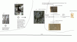
I hope you are all doing well. I had posted a few years ago some bits and pieces of information I had found on a site I was metal detecting. I'm unfortunately not close to the site now, but I would like to go back there again and see if I can find something. I have no information to connect it to anything, but the symbols I've found makes me curious that there may be something there. The below picture shows the site laid out and the most important symbols I found. I don't know if it's KGC or something older, but I hope you can give me some hints as to where you think to look. The animal symbol is on an opposite hill of the other symbols and is on a semi steep slope about 60 feet up. All of the symbols are between 150 and 200 ft apart. Please let me know any thoughts you have. Any input would be greatly appreciated.

Thanks.
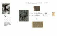

TreeLayouts.gif
 

OP
OP
C

chc1023

Jr. Member
Feb 6, 2012
28
38
Primary Interest:
All Treasure Hunting
They were all on beech trees. Edit: Except for the animal symbol. It was carved on an outcropping of rock.
 

Last edited:

mdog

Bronze Member
Mar 22, 2011
2,325
4,380
Hi All,

I hope you are all doing well. I had posted a few years ago some bits and pieces of information I had found on a site I was metal detecting. I'm unfortunately not close to the site now, but I would like to go back there again and see if I can find something. I have no information to connect it to anything, but the symbols I've found makes me curious that there may be something there. The below picture shows the site laid out and the most important symbols I found. I don't know if it's KGC or something older, but I hope you can give me some hints as to where you think to look. The animal symbol is on an opposite hill of the other symbols and is on a semi steep slope about 60 feet up. All of the symbols are between 150 and 200 ft apart. Please let me know any thoughts you have. Any input would be greatly appreciated.

Thanks.


View attachment 1687940

What’s the heading, from the tree on the left to the tree on the right? I would start at the right tree and look for artifacts, out to 150 feet.
 

mdog

Bronze Member
Mar 22, 2011
2,325
4,380
Hi All,

I hope you are all doing well. I had posted a few years ago some bits and pieces of information I had found on a site I was metal detecting. I'm unfortunately not close to the site now, but I would like to go back there again and see if I can find something. I have no information to connect it to anything, but the symbols I've found makes me curious that there may be something there. The below picture shows the site laid out and the most important symbols I found. I don't know if it's KGC or something older, but I hope you can give me some hints as to where you think to look. The animal symbol is on an opposite hill of the other symbols and is on a semi steep slope about 60 feet up. All of the symbols are between 150 and 200 ft apart. Please let me know any thoughts you have. Any input would be greatly appreciated.

Thanks.


View attachment 1687940

There must must be a trail close. How far off the trail are you?
 

mdog

Bronze Member
Mar 22, 2011
2,325
4,380
Measure the tree carvings and see if the measurements have something in common.
 

cyzak

Bronze Member
Jul 14, 2018
2,340
3,802
Mountains of Western Colorado
Detector(s) used
Garrett, General Mathematics, Geometry,Pentax,,Do the math it's there.
Primary Interest:
All Treasure Hunting
Are you near water say a lake or stream or spring.
 

OP
OP
C

chc1023

Jr. Member
Feb 6, 2012
28
38
Primary Interest:
All Treasure Hunting
mdog: The heading from the tree on the left to the one right is west. I can get an exact compass reading when I go back if needed. I have metal detected quite a bit to the right of that tree and I'll definitely do a lot more. All I had done previously was very erratic and unfocused. Metal detecting before, I had found a clevis and plenty of horse shoes. There is a road about 1 mile from the site that was supposedly a major stage coach road that connected several states.

cyzak: yes, there is a creek at the bottom of the hill.

I updated the picture (inserted below) to include the creek and the outline of hills and the size of the symbols with how far up the tree they were (from what I remember of them). I also, put on there another rock symbol I found on a free standing bolder on the hill. Sorry for the crappy artistic work and everything is definitely not to scale. The animal head was also pointing back down the hill to the other hill (almost pointing to the left tree). Thanks for all your input and questions!

TreeLayouts.gif
 

cyzak

Bronze Member
Jul 14, 2018
2,340
3,802
Mountains of Western Colorado
Detector(s) used
Garrett, General Mathematics, Geometry,Pentax,,Do the math it's there.
Primary Interest:
All Treasure Hunting
mdog: The heading from the tree on the left to the one right is west. I can get an exact compass reading when I go back if needed. I have metal detected quite a bit to the right of that tree and I'll definitely do a lot more. All I had done previously was very erratic and unfocused. Metal detecting before, I had found a clevis and plenty of horse shoes. There is a road about 1 mile from the site that was supposedly a major stage coach road that connected several states.

cyzak: yes, there is a creek at the bottom of the hill.

I updated the picture (inserted below) to include the creek and the outline of hills and the size of the symbols with how far up the tree they were (from what I remember of them). I also, put on there another rock symbol I found on a free standing bolder on the hill. Sorry for the crappy artistic work and everything is definitely not to scale. The animal head was also pointing back down the hill to the other hill (almost pointing to the left tree). Thanks for all your input and questions!

View attachment 1688409

Ok so you have tree carvings that is good and there high enough to be legit for the time period. Even better you have rock carvings they always backed it up if it was important rock can not go any were but trees can.What was ever hidden is not there in that location but it is always good to check the area especially if you have the time never know if something got dropped.I have never located anything in an area with signs present and believe me this is tough.I have a hunch you need to follow the creek you might possibly find another sign by it. Folks give me a hard time about tree carvings and they can mislead the rock is were it is at but believe me I have seen carvings in trees and they were legit but I am very wary of them.
 

mdog

Bronze Member
Mar 22, 2011
2,325
4,380
mdog: The heading from the tree on the left to the one right is west. I can get an exact compass reading when I go back if needed. I have metal detected quite a bit to the right of that tree and I'll definitely do a lot more. All I had done previously was very erratic and unfocused. Metal detecting before, I had found a clevis and plenty of horse shoes. There is a road about 1 mile from the site that was supposedly a major stage coach road that connected several states.

cyzak: yes, there is a creek at the bottom of the hill.

I updated the picture (inserted below) to include the creek and the outline of hills and the size of the symbols with how far up the tree they were (from what I remember of them). I also, put on there another rock symbol I found on a free standing bolder on the hill. Sorry for the crappy artistic work and everything is definitely not to scale. The animal head was also pointing back down the hill to the other hill (almost pointing to the left tree). Thanks for all your input and questions!

View attachment 1688409

The horseshoes might have been put there to give you a direction to go. If you can give me the heading from the A in U with the D underneath to the H in U with upside down A, it might give a clue as to who put it there. D, H and M are used at the site I study. The things here are carved in rock. One carving is a rectangle with a G M H B/D inside the box. The D has a horizontal line that makes it look like a 13. What you have is a, sort of, rectangle/diamond that could have the same symbolism as my carved box. Measure all the lines on all the trees and look for measurements that equal 13 or add up to 13. Measure the lines on the boulder too.

It's interesting about the stage road. Is it an east/west road and what states does it cross. Some of the stages carried bullion. You have a good spot a mile off the road and with cover by a creek.
 

franklin

Gold Member
Jun 1, 2012
5,036
7,168
Detector(s) used
Garrett ADS-7X, Fisher Two Box M-Scope, Mother Lode Locator, Dowsing Model 20 Electroscope, White's TM808, White's TM900, Inground Scanners
Primary Interest:
All Treasure Hunting
The number 13 signifies it as a KGC treasure location.
 

franklin

Gold Member
Jun 1, 2012
5,036
7,168
Detector(s) used
Garrett ADS-7X, Fisher Two Box M-Scope, Mother Lode Locator, Dowsing Model 20 Electroscope, White's TM808, White's TM900, Inground Scanners
Primary Interest:
All Treasure Hunting
Or, it COULD be a "B"... :coffee2:

Does not matter the "B" has the same meaning as "13" which means the letter "M" for Minerva or Athenia. The letter "H" or the 8th letter of the alphabet means a "King's Ransom in Gold with the presents of a "7" or silver with the presents of a "5" Since there is also the letter "G" which is the 7th letter of the alphabet means "gold" so now you have a "King's Ransom in gold"

And when you locate where the gold is be careful because with that amount of gold there will be booby traps or death traps.
 

OP
OP
C

chc1023

Jr. Member
Feb 6, 2012
28
38
Primary Interest:
All Treasure Hunting
mdog: The heading according to google earth (based on longitude and latitude I captured previously using my phone) is 270 degrees. I can try to get an exact compass heading the next time I get out there if needed. It will probably be about 2 weeks before I can. On the measurements of the lines, you are saying to measure the lines that create the symbols. Am I understanding that right?

I see what you're saying about the B now zooming in real close on the photo. It does look like a B. If there is something hidden that relates to these symbols, within how many feet or miles at most could it be hidden past the H tree?

Thanks for all your input! Please let me know if I didn't answer a question.
 

mdog

Bronze Member
Mar 22, 2011
2,325
4,380
mdog: The heading according to google earth (based on longitude and latitude I captured previously using my phone) is 270 degrees. I can try to get an exact compass heading the next time I get out there if needed. It will probably be about 2 weeks before I can. On the measurements of the lines, you are saying to measure the lines that create the symbols. Am I understanding that right?

I see what you're saying about the B now zooming in real close on the photo. It does look like a B. If there is something hidden that relates to these symbols, within how many feet or miles at most could it be hidden past the H tree?

Thanks for all your input! Please let me know if I didn't answer a question.

Yes, I was wondering about the heading from west to east. Sounds like you have 90 deg. I was looking for 85 deg., +or- a couple degrees. 8+5=13 and is a heading I have noticed very often in my research and google earth mapping, of treasure legend sites. I think it's Templar related but others might disagree.

Yes, measure all the letters and look for 13 inches. The B and M already indicate 13 but make sure you check all of them including the lines on the rock.

As far as where is the treasure buried, I don't know. I have a real complicated site that I think was just a decoy. But there was information there that led to another place several miles away, at a cemetery, and that was probably a decoy. My thoughts are, the guys who set this stuff up, are too smart to let you find it, and they're still around. Anything of great value, is more likely than not, buried on corporate property, under a lot of cement. That being said, there's nothing wrong with looking at the older signs and trying to figure them out.

Some other information that would be helpful, would be the distance from tree to tree, on the diamond shape, and the north/south and east/west lines, and the distance from the west tree to the rock with the lines on it. Also, what can you tell us about the stagecoach road?

Something else, you have three other guys watching your thread, Franklin, Rebel-KGC and L.C. Baker that know a lot more than I do about this stuff.
 

OP
OP
C

chc1023

Jr. Member
Feb 6, 2012
28
38
Primary Interest:
All Treasure Hunting
mdog: Sorry, I told you west when I meant to tell you east. I made the picture backwards from what it is in google earth and mucked it up. Considering the phone could be off in it's gps positioning it could very well be an 85 degree angle going from the H tree to the A tree. If so, would that indicate a direction to follow. And if I find either symbol or letter or group totaling 13, or anything that ends up having 13 in the total, that could be a directional instruction. Am I understanding that correctly?

I will definitely get that distance information. The stage road from what I understand connected Washington, D.C. to Georgia and went through Tennessee in the early 1900s. Before that time period I can't find anything about it, but the area it runs over appears to have been used in several different roads or routes in the past.

Thanks!
 

Top Member Reactions

Users who are viewing this thread

Top