Detailed route to Adams gold

Oroblanco

Gold Member
Jan 21, 2005
7,838
9,830
DAKOTA TERRITORY
Detector(s) used
Tesoro Lobo Supertraq, (95%) Garrett Scorpion (5%)
Adams Escape Route:
The route that Adams, and possibly a companion, followed after the Apache attack is one of the easiest parts of the LAD puzzle to figure. From the speculated location of the Adams placers on Bear Creek, it makes perfect sense that the survivors followed the same canyon downstream approximately twenty miles to the Gila River. They likely knew that once they reached the river, Fort West would be nearby, since the prospecting party crossed the wagon road leading to the fort near Mangas Springs (the “pumpkin patch”) on their trip into the diggings some weeks earlier. Also, some of the miners had been sent to the fort from the diggings for supplies - these men knew the way but were killed by the Apache on their return trip to the diggings. The map below summarizes the landmarks and escape route.

View attachment 1170199
Adams escape route


Malpais
Aka "bad country". This is usually assumed to mean a basalt lava flow, such as the Mount Taylor flow that lies generally east of the Zuni Mountains and west of Highway 114 in the Grants NM area - now the El Malpais National Monument. This is one of the anchor clues in the LAD versions that place the diggings somewhere westerly of Magdalena NM and easterly of Springerville AZ, and strongly tied to Fort Wingate, the “fort in the malpais”.


Many will object, but I'm ignoring the malpais reference. I generally reject the later versions of the LAD legend in lieu of the earlier tellings, and I also reject the malpais reference and its implications. I have spent a fair amount of time in this part of New Mexico trying to reconcile the Byerts et al versions of the legend to the terrain, and it just doesn't work for me. First, there is no gold in the area. That doesn't bode well. Second, it's too damned far from the Pima Villages. Third, it's too far from the Apache's primary venues. I suspect the reference was added solely to bolster a northern location for the diggings - for whatever reason. Obviously, I favor a southern location.


Dos Piloncillos
The two peaks appear in nearly all versions of the LAD legend, older and more recent ones. The Adams party’s guide pointed to the peaks from a high position as they began their final approach to the diggings. Many LAD versions place the peaks beyond the placer deposit, and some allude that the peaks were the source of, or were close to, a much richer gold source. The peaks were referred to as “dos piloncillos” - a reference to the cone-shaped lumps of hardened brown sugar common in the day (and today too, in certain places).


It’s likely that Twin Sisters Peaks, on the Continental Divide northeast of Pinos Altos, were the dos piloncillos. They are twin cone-shaped peaks and well-known landmarks in the region, visible for miles from several directions. The Adams party would have been shown the peaks from the head of Blacksmith Canyon, which they climbed from Mangas Springs to LS Mesa, as shown in a previous post. From this location, the peaks are visible on the horizon to the east, about thirteen miles away. From the suspected location of the diggings in Bear Creek, the peaks would have been accessible by traveling upstream a few miles, then climbing one of several possible routes to the top - about a 2,000 foot elevation gain. Below is a line-of-sight profile from LS Mesa to Twin Sisters.

View attachment 1170192
Analysis using Maptech


To sweeten the deal, there are several rich mine/lost treasure traditions in close proximity to Twin Sisters. They are not associated directly to the events of the Adams party except by vague reference in the stories and won’t be expounded on here. Interestingly, the horizontal rock structure connecting the peaks was a view point for Adams at the beginning of later efforts by him and others trying to return to the placer diggings.

View attachment 1170193
Approaching Twin Sisters from the west

Another great post amigo! :thumbsup: :notworthy:
 

OP
OP
sdcfia

sdcfia

Silver Member
Sep 28, 2014
3,657
8,879
Primary Interest:
Other
This is a fastening thread! But so far, no one has suggested that the Bear Creek location fits any of the "clues" reported on the Adams Route maps.. unless I am having another "senior moment". Has this point been discussed in another thread? I agree that documented historical evidence suggests that Bear Creek is the logical location for the LAD, but do the pumpkin patch, rock house, "little door", zig zag canyon, big square rock, etc. fit into this area as well as the location that Dick French reports in his latest book?

There is one issue, however, that give me pause about Dick's "Return to the Lost Adams Diggings": I cannot find any "waterfall" upstream from the places that the Adams party worked. Having not been to the location, I can only rely on topo maps and GoogleEarth. Neither source shows terrain that suggests a geological structure that might have supported a waterfall in the 1860s..... unless the "waterfalls" were created by temporary debris created and collected during a local flood and was later washed away by another. If the latter circumstance was the case, perhaps this "discrepancy" can be explained.

Has anyone been able to match the reported Adams map clues to a possible route into and in the vicinity of Bear Valley?

Bill, I believe I am the first to attempt to flesh out the idea that the Bear Creek placers are the Lost Adams Diggings, although I suspect that this may have been realized long ago by many Southwesterners during Adams' time - Snively, obviously IMO. When Adams - a convincing liar by many accounts - told his many conflicting stories of the adventure, eager searchers began scurrying all over Arizona and New Mexico trying to place the clues he gave to so many. It didn't take long for the legend to take on a life of its own, as as time went on, the facts (whatever they were) became terribly corrupted and conflicting. Without facts, we have a legend, often embraced by hard core zealots. Lost mine legends generally aren't solved.

As Oro suggested in this thread, it's probably a good idea to focus on the earliest material you can locate. The "northern location" material was late to the game, and as I mentioned in a previous post, I feel that it's disinformative. As far as maps are concerned, I would need solid provenance for any "treasure map" before taking it seriously. I don't mean to cast aspersions on the work Hale and French (a great researcher and writer) have done. They have put together an interesting argument. I just don't happen to agree with their conclusions.
 

Last edited:

Oroblanco

Gold Member
Jan 21, 2005
7,838
9,830
DAKOTA TERRITORY
Detector(s) used
Tesoro Lobo Supertraq, (95%) Garrett Scorpion (5%)
Bill, I believe I am the first to attempt to flesh out the idea that the Bear Creek placers are the Lost Adams Diggings, although I suspect that this may have been realized long ago by many Southwesterners during Adams' time - Snively, obviously IMO. When Adams - a convincing liar by many accounts - told his many conflicting stories of the adventure, eager searchers began scurrying all over Arizona and New Mexico trying to place the clues he gave to so many. It didn't take long for the legend to take on a life of its own, as as time went on, the facts (whatever they were) became terribly corrupted and conflicting. Without facts, we have a legend, often embraced by hard core zealots. Lost mine legends generally aren't solved.

As Oro suggested in this thread, it's probably a good idea to focus on the earliest material you can locate. The "northern location" material was late to the game, and as I mentioned in a previous post, I feel that it's disinformative. As far as maps are concerned, I would need solid provenance for any "treasure map" before taking it seriously. I don't mean to cast aspersions on the work Hale and French (a great researcher and writer) have done. They have put together an interesting argument. I just don't happen to agree with their conclusions.


Can't disagree with your post. On the waterfall - it is not mentioned at all in the earliest versions of the story, not to say it is untrue, perhaps Adams kept that detail closer to the chest until he had failed to find the location a time or two, but anyway it is really tough to see waterfalls on topos or even satellite images unless they are quite sizable. As an example, nearly 200 previously unknown waterfalls have been discovered in Yellowstone Park (Wyoming) in recent years, even though millions of visitors have been to the park, the whole park has been fully mapped for many years and many are hiking the backcountry every year.
Yellowstone Waterfalls

I know of a waterfall in the east, on a little creek named Tea creek, that was not known even to the people living less than a half mile away,<some may not know of it still for that matter, we did not broadcast it> and it was a rather spectacular one with a drop of nearly 100 feet over a cliff into a huge and deep pool. We discovered a pretty, hidden waterfall in AZ a few years ago, which however goes dry in winters - it is possible that the waterfall of the Adams story could be similar in that it has water only at certain times of the year.

It would help if we knew how far away the waterfall was, from the exact site where Adams party was working. Were they working right at the foot of it, or was it up the canyon some distance, or in a side canyon..? Also a detailed description of the waterfall would be helpful.

Please do continue:
:coffee2: :coffee2:
 

OP
OP
sdcfia

sdcfia

Silver Member
Sep 28, 2014
3,657
8,879
Primary Interest:
Other
Can't disagree with your post. On the waterfall - it is not mentioned at all in the earliest versions of the story, not to say it is untrue, perhaps Adams kept that detail closer to the chest until he had failed to find the location a time or two, but anyway it is really tough to see waterfalls on topos or even satellite images unless they are quite sizable. As an example, nearly 200 previously unknown waterfalls have been discovered in Yellowstone Park (Wyoming) in recent years, even though millions of visitors have been to the park, the whole park has been fully mapped for many years and many are hiking the backcountry every year.
Yellowstone Waterfalls

I know of a waterfall in the east, on a little creek named Tea creek, that was not known even to the people living less than a half mile away,<some may not know of it still for that matter, we did not broadcast it> and it was a rather spectacular one with a drop of nearly 100 feet over a cliff into a huge and deep pool. We discovered a pretty, hidden waterfall in AZ a few years ago, which however goes dry in winters - it is possible that the waterfall of the Adams story could be similar in that it has water only at certain times of the year.

It would help if we knew how far away the waterfall was, from the exact site where Adams party was working. Were they working right at the foot of it, or was it up the canyon some distance, or in a side canyon..? Also a detailed description of the waterfall would be helpful.

Please do continue:
:coffee2: :coffee2:

I can guarantee you that, depending upon which route you choose, you will encounter waterfall(s) if you hike from Bear Creek up to Twin Sisters Peaks. Or up any of the drainages of Pinos Altos Mountain, where many rich lode mines were developed. Interestingly, back in the late 1970s, when there were still prospectors and small time miners active around Pinos Altos, the late Tommy Donahue used to repeat stories about a lost gold vein near a waterfall. Of course, these things could occur in any number of places. Also, it depends on what is meant by a "waterfall". A perennial waterfall, or one formed only with a storm runoff? Is it a five foot high drop? Ten? Fifty?

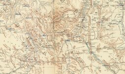
OT: Here's a good reference of the AZ-NM territory in the 1860s - it's a section of "Map of the Military Department New Mexico" (Carlton, Anderson, 1864). One can trace a route from the Arizona Pima Villages easterly into New Mexico - there are more than one option. In New Mexico, Mangas Springs is shown (called Agua de Santa Lucia then), Fort West (misspelled) on the Gila River, the wagon road serving the fort, Bear Creek and Pinos Altos. Also shown are the Santa Rita Copper Mines and Ojo de San Vicente, where Silver City would be established in 1870.

LAD arena.jpg
 

Last edited:

motel6.5

Sr. Member
Mar 27, 2012
355
367
Nevada,Calif.,Utah,Arizona
Primary Interest:
All Treasure Hunting
I am going to write here the short version which I hope won"t be to long. After studying my L.A.D. documents for the up-teenth time, I fell a sleep. During my slumber I dreamed of a long sliver cross , and when I woke up their was a certain word in my old brain, which I looked up on the internet. After that it sort of all came together for me. Another words if I were searching for the L.A.D.I would know exactly what to look for,which I won"t reveal. In my thoughts the L.A.D. is a very ancient site and extremely scared to the Indians.There are probably Indian scouts there on a regular basis today to keep it that way. After all these exhausting visions to myself, I have decided to destroy all information I have on the L.A.D. The short version. How about that Gotch-Ear and Chief Nana.
 

Last edited:
OP
OP
sdcfia

sdcfia

Silver Member
Sep 28, 2014
3,657
8,879
Primary Interest:
Other
I am going to write here the short version which I hope won"t be to long. After studying my L.A.D. documents for the up-teenth time, I fell a sleep. During my slumber I dreamed of a long sliver cross , and when I woke up their was a certain word in my old brain, which I looked up on the internet. After that it sort of all came together for me. Another words if I were searching for the L.A.D.I would know exactly what to look for,which I won"t reveal. In my thoughts the L.A.D. is a very ancient site and extremely scared to the Indians.There are probably Indian scouts there on a regular basis today to keep it that way. After all these exhausting visions to myself, I have decided to destroy all information I have on the L.A.D. The short version. How about that Gotch-Ear and Chief Nana.

Six-five, if you identified what your vision revealed, perhaps we could comment. Concerning the Adams placer site, yes, it was rich. Snively made off with thirty pounds (sixty, according to some) in twelve days' panning. The Bear Creek placers were then worked to their economic end during the next thirty years. Recreational placer miners still play around there today.

But the reason the Adams party was wiped out is alleged by many to be because they were ignoring the Apaches' warning about prospecting above the placer deposit. I don't believe this upper site was a "sacred" area to the Apaches. I believe it was a "dangerous" location for the tribe - one with a history they were aware of for many years. I say dangerous because they knew what would result if the Anglos discovered it - their Pinos Altos homeland would be overrun and they would be permanently pushed out. Of course, this is exactly what happened as many lode deposits were soon discovered in the area and Pinos Altos became a gold mining zone for decades - gold from lode mines as the placer deposits eventually diminished, then played out.

Ironically, it's my opinion that the specific site that the Apaches warned the Adams group to avoid was not discovered and still exists somewhere in the general vicinity of Twin Sisters Peak.
 

OP
OP
sdcfia

sdcfia

Silver Member
Sep 28, 2014
3,657
8,879
Primary Interest:
Other
Excellent analysis, sdcfia. My complements, and I suspect you are correct, in most or all of your conclusions.

JB

Thanks, JB. This puzzle is mind-boggling when you consider all the conflicting stories that Adams turned loose on the world. IMO, he either did this because of a weak mind or character - or both - or because he was hiding something. Either way, after years of frustration, I decided that if there was any truth to the legend, then the only way I would be able make any sense out of it would be not to pick my favorite version and nurture it, but to reject them all and start over on my own.

I tend to rely on facts and hard logic when trying to understand historic events. With the LAD, I started with a selection of key landmarks, players, and events that seemed to be reasonably common to most versions of the legend. Then I looked at the political, cultural and economic state of affairs in Arizona and New Mexico during the 1860s. I read many unrelated first hand historic accounts by others who were in the area during the same period. I considered the geology of the region, figuring that the best odds of finding a rich gold deposit would be where there was a history of rich gold discoveries. Since I've always been fascinated with Jacob Snively - and was aware of allegations that he may well have been the LAD Dutchman - I tried to work him into the mix. I ignored all the LAD hoopla from the past 150 years and imagined myself in the area during the 1860s. The result is the speculation I've laid out in this thread. I know most will likely reject my theory out of hand in lieu of their own ideas, but it is what it is - a simple solution, really. If new factual evidence surfaces that causes me to adjust my ideas, then I will move on where the facts lead - all I care about is the truth of the matter, whatever it is.
 

Loke

Hero Member
Mar 24, 2010
589
1,383
Republic of Texas
Primary Interest:
All Treasure Hunting
I am impressed by the data you have shared - a simple 'like' is insufficient! You have made an excellent case for where it ought to be - also, simple is often the best. The more we entrench ourselves in theories, the more complicated it all becomes, occasionally we end up with conspiracies and such like in order to make our theory fit.
For one - you have screwed up all my previous ideas about its whereabouts, however, I am never too proud to admit being wrong ;-)
And no *chuckles* I'm not gonna run out to see if it can be found (got my own fish to fry)! Maybe some other time ... but again, thank you for what you have shared - much appreciated!
 

OP
OP
sdcfia

sdcfia

Silver Member
Sep 28, 2014
3,657
8,879
Primary Interest:
Other
I am impressed by the data you have shared - a simple 'like' is insufficient! You have made an excellent case for where it ought to be - also, simple is often the best. The more we entrench ourselves in theories, the more complicated it all becomes, occasionally we end up with conspiracies and such like in order to make our theory fit.
For one - you have screwed up all my previous ideas about its whereabouts, however, I am never too proud to admit being wrong ;-)
And no *chuckles* I'm not gonna run out to see if it can be found (got my own fish to fry)! Maybe some other time ... but again, thank you for what you have shared - much appreciated!

Thanks, Loke - I'm glad that you've enjoyed the thread. Good luck with your own fish fry!
 

OP
OP
sdcfia

sdcfia

Silver Member
Sep 28, 2014
3,657
8,879
Primary Interest:
Other
Hi Sdcfia, I will post from my notes what I can. I have not read all these threads and the others on the L.A.D.
I really cannot say what I post is 100% accurate. I do agree with you the L.A.D.has not been been located yet.
I am posting in no paticular order, my spelling is not the best right now ,as I am tired.

1) Emil Schaeffer the German,sold 65pounds3ounces,to a storekeeper named Hinton in Yuma.
2) The L.A.D. group picked up their re- supplys at Fort Wingate, about a 8 day ride from the L.A.D.
3) When the group returned they were masacured at the top of the Zig/Zag.
4) The pumkin patch was a old Indian camp with a drainage ditch running down 1 side
5) U.S. Caverly found Adams and Davidson in the desert, took them to Ft.Apache.
6) The Indians told Adams not to let his men go above the Falls, as their people were camped there.
7) The Sugar Cones are past the L.A.D., to be used as a marker/map point.
8) Byerts, might have located the L.A.D
9) The Malpis should not be disregareded as a possible.
10) Adams was at a Indian camp where he met the other L.A.D. men and Gotch-Ear. He agreed to join the group and added his 12 horses ? he was going to trade to the Indians. From the camp it was about a 10 day ride.
End.

I agree - IMO, the so-called ultra-rich gold deposit above the Bear Creek placers remains undiscovered.

I'll take a stab at the ten points you listed:
1) I've seen the Dutchman referred to as "Emil Shaeffer" before in some of the LAD versions. Also, he is apparently identified as the Shaeffer of "Lost Shaeffer Diggings" fame. Baxter and others were convinced that the Lost Shaeffer Diggings, Lost Snively Diggings and Lost Adams Diggings were all one and the same. It's my feeling that Snively, for whatever reason, used the alias Emil Shaeffer during the LAD expedition. I still have many questions concerning the identities of the twenty or so (more or less) members of the expedition. Also, why would Snively give a false name when he joined them?

2) I believe the expedition took place in the southern part of New Mexico in 1863, and Fort West was the supply point, not more than a long day's ride for men on horseback.

3) Makes sense.

4) I agree - it was at Mangas Springs NM.

5) The survivors could not have been taken to Fort Apache because this fort didn't come into service until 1870, several years after the Adams expedition. IMO, the survivors were taken to Fort West.

6) I agree that the Apaches warned the Adams party not to go above the placer diggings.

7) I agree.

8) I haven't seen anything to make me believe this.

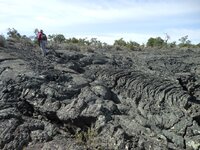
9) There are various forms of malpais. Many of the mesas and canyons in the southwest are old basaltic flows that have weathered and been grown over with vegetation. Many other southwestern canyons are rimmed by vertical columns of volcanic tuff. These can be referred to as "malpais", or "bad country". The malpais that you are referring to is the McCartys Flow, one of the youngest on the continent - a thin layer of fresh looking black lava. It came from Mount Taylor and sits on top of barren flat ground with no mineral history. One man's malpais is another's bad country. I reject the McCartys Flow as a LAD site because there is minimal chance of gold there.

10) I agree.

McCartys.jpg
McCartys Flow (free-use photo)
 

Curious_George

Jr. Member
Jul 15, 2013
37
45
MN
Primary Interest:
Other
Fascinating thread! Here I was wondering why no one was responding to my questions and analysis re: Dick French's new book.. and now I know.

Sorta reminds me of the ongoing debate re: LDM, as to whether it's been found.

I'm not sure it matters, except for those who still search for gold in the Supes, as anecdotal evidence seems to indicate that ~ $400,000,000 in gold was worked out of a mine in the Iron Mtn/ Pinto Creek area from 1997-1999, and possibly moved out of the area ~ 5 years later.

When you find gold in that quantity, who cares if it was the LDM?

If a similar crazy amount of gold can be found in the Bear Creek/ Pintos Alto area or the Old Canyon area of Dick's book, who cares if it's the LAD or not?

... or, are we "doomed to just keep searching?", sailing the 7 seas like the legendary ship?

George
 

OP
OP
sdcfia

sdcfia

Silver Member
Sep 28, 2014
3,657
8,879
Primary Interest:
Other
Fascinating thread! Here I was wondering why no one was responding to my questions and analysis re: Dick French's new book.. and now I know.

Sorta reminds me of the ongoing debate re: LDM, as to whether it's been found.

I'm not sure it matters, except for those who still search for gold in the Supes, as anecdotal evidence seems to indicate that ~ $400,000,000 in gold was worked out of a mine in the Iron Mtn/ Pinto Creek area from 1997-1999, and possibly moved out of the area ~ 5 years later.

When you find gold in that quantity, who cares if it was the LDM?

If a similar crazy amount of gold can be found in the Bear Creek/ Pintos Alto area or the Old Canyon area of Dick's book, who cares if it's the LAD or not?

... or, are we "doomed to just keep searching?", sailing the 7 seas like the legendary ship?

George

French is a darned good writer and Hale did a lot of work on the LAD - they should be commended for their efforts. However, I don't believe the LAD events took place in that part of New Mexico for reasons I've laid out in this thread. I realize that many would disagree with my conclusions and would support French/Hale. We all have to decide for ourselves.

$400,000,000? Is this a misprint? That is more than 300,000 ounces of gold - how do you keep something this big under the radar? Sounds like either a tall tale or something very greatly exaggerated.

We care about the LAD because it's an unsolved mystery - a big one. We're curious, Curious George.
 

Thirsty44

Greenie
Apr 9, 2009
17
23
Sdcfia,

I have only a very casual interest in the Lost Adams Diggings legend, so my opinion on your theory regarding its location isn't worth much. But your logic certainly sounds plausible to me, and I'll be very interested in reading and pondering the discussion that's sure to follow.

My main reason for posting this is to say that it's a real pleasure to read such a well-thought-out, well-written theory on a treasure legend. And the maps and illustrations are perfect too. I wish more threads at this site were like yours. Good job!
 

OP
OP
sdcfia

sdcfia

Silver Member
Sep 28, 2014
3,657
8,879
Primary Interest:
Other
Sdcfia,

I have only a very casual interest in the Lost Adams Diggings legend, so my opinion on your theory regarding its location isn't worth much. But your logic certainly sounds plausible to me, and I'll be very interested in reading and pondering the discussion that's sure to follow.

My main reason for posting this is to say that it's a real pleasure to read such a well-thought-out, well-written theory on a treasure legend. And the maps and illustrations are perfect too. I wish more threads at this site were like yours. Good job!

Thanks for the kind words, Thirsty!
 

Curious_George

Jr. Member
Jul 15, 2013
37
45
MN
Primary Interest:
Other
French is a darned good writer and Hale did a lot of work on the LAD - they should be commended for their efforts. However, I don't believe the LAD events took place in that part of New Mexico for reasons I've laid out in this thread. I realize that many would disagree with my conclusions and would support French/Hale. We all have to decide for ourselves.

$400,000,000? Is this a misprint? That is more than 300,000 ounces of gold - how do you keep something this big under the radar? Sounds like either a tall tale or something very greatly exaggerated.

We care about the LAD because it's an unsolved mystery - a big one. We're curious, Curious George.

No, $400,000,000 is NOT a misprint, and I totally understand and agree that a major part of the allure of the LAD IS the mystery (oh, yes... and the gold)-- which was actually the point of my post-- once the mystery is solved, the "juice' around/ about a mystery dissolves, like the mystique around the Titanic.

I was a Titanic fan "before it was cool"--- and found that after it was found, the reality wasn't the same as the mystique.

As to the $400,000,000 taken out of the Supes, that will take another email... maybe this weekend.

CG
 

motel6.5

Sr. Member
Mar 27, 2012
355
367
Nevada,Calif.,Utah,Arizona
Primary Interest:
All Treasure Hunting
Sdcfia, There were 2 Ft Wingates, as I am sure you know. {1st}Was built 1849 at Seboyeta, then moved to San Rafael. {2nd}, Priorer to 1868 Fort Wingate was Fort Lyon{1861} and Fort Fauntleroy{1860}.
Adams plus his group of 21 others went on their treasure hunt in the year 1864. Its a good bet they stopped at Ft Lyon for provisions and latter again for there return trip to the L.A.D.
Fort Apache a military post was established in 1863./ where Adams and Davidson were taken.
I could find no imformation on your Fort West.
 

OP
OP
sdcfia

sdcfia

Silver Member
Sep 28, 2014
3,657
8,879
Primary Interest:
Other
No, $400,000,000 is NOT a misprint, and I totally understand and agree that a major part of the allure of the LAD IS the mystery (oh, yes... and the gold)-- which was actually the point of my post-- once the mystery is solved, the "juice' around/ about a mystery dissolves --

That's a very good point! Life would be pretty damned dull if we all knew all the answers to everything. Maybe that's the reason we're here - to try to understand all the things we don't.
 

OP
OP
sdcfia

sdcfia

Silver Member
Sep 28, 2014
3,657
8,879
Primary Interest:
Other
Sdcfia, There were 2 Ft Wingates, as I am sure you know. {1st}Was built 1849 at Seboyeta, then moved to San Rafael. {2nd}, Priorer to 1868 Fort Wingate was Fort Lyon{1861} and Fort Fauntleroy{1860}.
Adams plus his group of 21 others went on their treasure hunt in the year 1864. Its a good bet they stopped at Ft Lyon for provisions and latter again for there return trip to the L.A.D.
Fort Apache a military post was established in 1863./ where Adams and Davidson were taken.
I could find no imformation on your Fort West.

That's the problem with Adams - he told so many different stories to so many different people, he had a hard time keeping the lies sorted out. Same goes for Shaw.

Versions of the story attributed to Adams gave dates for the gold mining expedition that ranged from 1858 to 1869. Many feel it was 1864, but at this point, I believe it was 1863.

Fort Wingate is off the radar for me because I don't accept the northern section of New Mexico as the diggings site, for the many reasons I've covered in this thread.

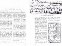
Fort Apache
Apache.jpg
Frontier Military Posts of Arizona, Ray Brandes, page 10


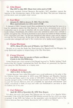
Fort West
West.jpg
Forts of New Mexico, Dr. Dale F. Giese, page 19
 

Top Member Reactions

Users who are viewing this thread

Top