Detailed route to Adams gold

sdcfia

Silver Member
Sep 28, 2014
3,650
8,867
Primary Interest:
Other
Detailed route to Adams' gold

Many searchers claim to have located the Lost Adams Diggings during recent decades. As far as I can determine, one key element missing from these solutions is the most important one - nobody has proven either gold existed at their target site or that there was a reasonable potential for a substantial deposit of gold nearby. I have spent a fair amount of time since the late 1970s pondering the LAD, and have explored a few of the favored search zones where much attention has been focused on the legend. My current working model indicates a strong probability that the Adams placer field was in Bear Creek, several miles downstream from the village of Pinos Altos NM.


Landmarks that have been reported to fit this legend are present in numerous locations in eastern Arizona and western New Mexico, generating reports through the years that the LAD has been found in many diverse places. Much of the confusion with the Adams legend results from the fact that more than two dozen versions of the story are extant - many of them similar, some of them quite at odds with the others. The ample choices available of described routes, vaguely identified landmarks and descriptions of the terrain followed by the Adams party leave the reader in the uncomfortable position of having to choose which version to believe. For whatever reason, researchers generally tend to favor certain tellings at the exclusion of the rest.


My analysis of the LAD begins with a two-stage filter. First, where is a likely area where the possibility of both rich placer gold and nearby lode gold exists? The deposits would have to have been obvious, considering that the Adams party reportedly recovered a substantial amount of gold in a relatively short time, and the Apache were apparently well aware of the diggings. Second, can an acceptable number of LAD landmarks and terrain descriptions fit with the expedition's route that presumably began at the "Pima Villages” - the central Arizona region just south of today's Phoenix - and terminated at the gold deposits? Using this filter, I suspect that the Adams party discovered the placer deposit in Bear Creek or one of its tributaries.


Some key talking points will follow. I believe that by referring to reasonably detailed maps (USGS topo, Forest Service and historical), the LAD route will be easy for the reader to follow. The analysis is a simple and obvious solution to a long-lived enigma - and it leads to gold. The concept of Occam’s razor suggests that the simplest option is often the best solution to a complex problem. Judge for yourself.


Route to the Diggings
The Adams party likely followed established trails along the Gila River from the Pima Villages easterly into New Mexico. The river has several difficult sections, probably necessitating detours. The group’s Native guide would have known the easiest route and it makes sense that the trip would have taken about two weeks for a large group on horseback.


At Mangas Creek, the party likely left the Gila River and travelled east, upstream to Mangas Springs, the well-known Apache rancheria - a farming area under the control of Mangas Coloradas’ band. This was the “pumpkin patch" described in some of the LAD versions and earlier by the Walker Party when they visited in 1861.


Near Mangas Springs, the Adams party would have crossed the "wagon road" from Las Cruces that led northwest to Fort West, further upstream on the Gila River, about two miles south of Cliff NM. The Fort was in service January 1863 to January 1864. This would seem to date the LAD events to the summer of 1863.


Traveling east from here, the guide led the horsemen up a narrow winding canyon - likely Blacksmith Canyon - to the top of LS Mesa. This is about a 1,200 foot climb. From this position, Bear Mountain - a large local landmark - rises above them two miles to the south. About twelve miles easterly, “dos piloncillos” (Twin Sisters Peaks) are visible on the horizon.


The party would have now turned north, following the mesa top until they dropped off easterly about 500 feet into Walnut Canyon, which they followed north until it emptied into Bear Canyon, at a point just east of Dorsey Ranch. Here, the party has arrived at the western terminus of a ten-mile stretch of placer deposits that produced gold off and on from the Spanish era until the late twentieth century.


Next: Details about the gold fields; circumstances leading to the Apache attack.
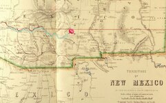
new_mexico_territory.jpg
 

Last edited:

Oroblanco

Gold Member
Jan 21, 2005
7,837
9,826
DAKOTA TERRITORY
Detector(s) used
Tesoro Lobo Supertraq, (95%) Garrett Scorpion (5%)
Bear creek - interesting! Never been there even to look. No questions just yet, please do continue. :thumbsup:

:coffee2: :coffee2:
 

motel6.5

Sr. Member
Mar 27, 2012
355
367
Nevada,Calif.,Utah,Arizona
Primary Interest:
All Treasure Hunting
Chief Nana said the canyon was named Sno-ta-hay, entrance behind a huge bolder, through a large gap in the mountain wall,and down a zig- zag -path to the bottom, of a boxed walled in canyon at both ends. 1 entrance in and the {same} only way out. _DSC1882.JPG
 

Oroblanco

Gold Member
Jan 21, 2005
7,837
9,826
DAKOTA TERRITORY
Detector(s) used
Tesoro Lobo Supertraq, (95%) Garrett Scorpion (5%)
Just to fuel the discussion, Jacob Snively is a most interesting person:

snively-1858-gila-bend.jpg
<Jacob Snively discovers Gila Bend placers 1858>

snively-discovers-lead-1863-4.jpg
<Snively discovers lead 1863-64>

snively-killed-1871.jpg
<Snively killed by Apaches 1871>

Col. Jacob Snively was involved in discovering and mining lead in western AZ in 1863-64, and dead by 1871. I don't think Jacob Snively was the "German" of the Adams original story. :dontknow: However I would like to hear your reasons for thinking he is, thanks in advance.
:coffee2: :coffee2:
 

OP
OP
sdcfia

sdcfia

Silver Member
Sep 28, 2014
3,650
8,867
Primary Interest:
Other
Chief Nana said the canyon was named Sno-ta-hay, entrance behind a huge bolder, through a large gap in the mountain wall,and down a zig- zag -path to the bottom, of a boxed walled in canyon at both ends. 1 entrance in and the {same} only way out.

I'm aware of those descriptions and can only wonder why such a place has never been found, despite 150 years of searching every possibility in Arizona and New Mexico by so many seasoned prospectors and explorers. Perhaps the description is in error. When you think about how many different tellings of the tale exist, it's a fact that they can't all be accurate. My proposal verifies many of the well-known markers and leads to gold.
 

S

stefen

Guest
I'm aware of those descriptions and can only wonder why such a place has never been found, despite 150 years of searching every possibility in Arizona and New Mexico by so many seasoned prospectors and explorers. Perhaps the description is in error. When you think about how many different tellings of the tale exist, it's a fact that they can't all be accurate. My proposal verifies many of the well-known markers and leads to gold.

The real proof to any hypothesis is the actual finding of the site.
 

Oroblanco

Gold Member
Jan 21, 2005
7,837
9,826
DAKOTA TERRITORY
Detector(s) used
Tesoro Lobo Supertraq, (95%) Garrett Scorpion (5%)
I'm aware of those descriptions and can only wonder why such a place has never been found, despite 150 years of searching every possibility in Arizona and New Mexico by so many seasoned prospectors and explorers. Perhaps the description is in error. When you think about how many different tellings of the tale exist, it's a fact that they can't all be accurate. My proposal verifies many of the well-known markers and leads to gold.

I must respectfully AGREE with this part in bold - in fact I would say it is almost a certainty that something, perhaps several things are erroneous or faulty about the description. Treasure legends have a way of getting mixed together by treasure hunters and treasure writers, thinking two or more separate, unrelated stories are really talking about the same thing and before long the original story has grown into something that never existed. So I owe you another cigar, or at least a cup of camp coffee. Can't find anything in your post to really disagree with, and finding gold is a major requirement to prove that a lost gold mine is found.

Please do continue;
:coffee2: :coffee2:
 

OP
OP
sdcfia

sdcfia

Silver Member
Sep 28, 2014
3,650
8,867
Primary Interest:
Other
Location and History of the Adams Placer Gold and the Apaches’ Involvement

Placer deposits in Bear Creek and its tributaries were recovered by Spaniards from the nearby Santa Rita del Cobre mine beginning in 1837 under the supervision of General Pedro Aimendaris (History of New Mexico, George B. Anderson). However, local traditions and earlier Spanish military records from Janos, Mexico indicate that the placers were known of and exploited as early as the mid-1700s (Campaigning on the Upper Gila, 1756, John L. Kessell). John C. Cremony, scout and interpreter for the US Boundary Commission, reported Anglo placer miners working in the Pinos Altos canyons in 1850 (Life Among the Apaches, Cremony). The “official” discovery of gold in Pinos Altos is attributed to Col. Jacob Snively and two others, Birch and Hicks, who found gold in Bear Creek in May, 1860 and founded Birchville near the discovery point - likely near the mouth of Rich Gulch. By December that year there were 1,500 prospectors panning the streams. It was reported that during the last half of 1860, most of the placer miners were recovering an average of at least a half ounce of placer gold per day (Anderson, op cit). The first quartz lode claim was located in December, 1860 by Thomas Mastin on Pinos Altos Mountain on the Continental Divide. More rich lode claims quickly followed, thirty of which averaged two to twelve ounces of gold to the ton in 1861 and 1862 (Anderson, op cit).

The Birchville mining camp and the surrounding mountains were a greatly favored location by Mangas Coloradas, the great Apache leader, who ironically is said to have had a secret gold mine himself somewhere in the area (The Marvelous Country, Samuel Cozzens). In an effort to drive out the Anglos, the Apaches began a campaign of harassment and guerrilla warfare against the miners who had flocked to the camp. The miners were constantly menaced the first winter of their occupation and all through 1861. On September 27, 1861, 500 Apaches led by Mangas and Cochise attacked the village, killing several Anglos. Fearing more danger, most of the miners then abandoned the camp. Some moved on to other diggings, and many joined the Confederate army and became involved in the Civil War. Those few who remained changed the town’s name back to its original Pinos Altos and continued to work the rich lode claims near town where it was somewhat safer. The placer claims in the outlying canyons, including Bear Creek, were totally abandoned for about the next three years.

Lode mining on a limited scale continued in Pinos Altos through 1862, punctuated with frequent Apache depredations. The Bear Creek placers remained inactive because of the danger of working in the remote canyon some miles downstream of the town. Mangas Coloradas was invited to peace talks with US military leaders in January, 1863, but was instead arrested, tortured and murdered. This infuriated the Apaches, who then began waging a much more widespread guerilla war against all Anglo settlers, miners or not.

With the presence of the US military and local militia forces, mining in Bear Creek became more secure, and placer miners finally began to repopulate the camp and refile on their lapsed claims in 1864. By 1866, the placer claims on Bear Creek, from the Pinos Altos townsite downstream ten miles to the Dorsey Ranch, were consolidated and issued mineral patents. These claims remained operational until the early 20th century, then enjoyed a resurgence of activity during the Depression and World War II years. The last serious mining effort occurred ca 1980. The Forest Service purchased the claims ca 2012 in order to create a riparian zone along their extent.

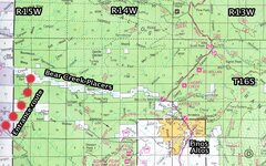
Below is a portion of the 2011 Gila National Forest map showing the Bear Creek patented placer mining claims. The original patents were all filed in Las Cruces NM on July 26, 1886, and include the following: Bear Creek No 2 Placer (320 acres); Bear Creek No 2 Placer (320 acres); Mary Jane Placer (160 acres); Gold Brick Placer (20 acres); Homestead Placer Claim (20 acres); and Powers Flat Placer Mine (15.80 acres).

BC placers.jpg

It is impossible to identify where along Bear Creek that the Adams party may have recovered their gold. Logically, It seems that the LAD location might have been towards the eastern portion of the patented claims, since this was historically the most productive area. However, the western section likely had been worked far less when the camp was temporarily abandoned late in 1861, only a year or so after the district’s discovery. For this reason, my speculation is that the western Bear Creek zone is the most likely Adams site. Also, this better explains why the Adams party would have been unaware of the existence of the Pinos Altos townsite upstream of them several miles - a direction that the Apaches warned them not to approach. In 1863, the year of the LAD events, Bear Creek was still abandoned and dangerous due to Indian trouble, and the few Pinos Altos inhabitants remaining there would have had no idea that the Adams party was nearby - western Bear Creek was a remote area at that time, and remains so today.

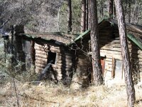
There were several old cabins and cabin ruins still in existence along Bear Creek as recently as the 1970s. Most have been destroyed or salvaged. There is currently no evidence that links any of the ruins to the Adams party.

Next: Jacob Snively.
 

Last edited:
OP
OP
sdcfia

sdcfia

Silver Member
Sep 28, 2014
3,650
8,867
Primary Interest:
Other
The real proof to any hypothesis is the actual finding of the site.

I totally agree. As you know, it's my speculation that the Adams party found rich placer somewhere on the western portion of the Bear Creek Placers near Pinos Altos NM the summer of 1863. The party was fortunate in that their expedition coincided with a window of opportunity in which the recently discovered Bear Creek placer claims had been temporarily abandoned due to fear of Apaches in the canyon. That fear from the original claim holders was obviously well-justified, considering the fate of the Adams party. As far as the "finding of the site", I think that the LAD site was simply reclaimed when the Apache problems subsided and the miners returned to Bear Creek in 1864.
 

motel6.5

Sr. Member
Mar 27, 2012
355
367
Nevada,Calif.,Utah,Arizona
Primary Interest:
All Treasure Hunting
My personal thoughts is that the Apaches landscaped the location as I described in a earlier post to disappear any clues to its entrance. My research shows the Adams group built a cabin which the Indians burned down. The Adams group while still alive and picking nuggets buried their stash underneath the fireplace hearth in the cabin. That is all except the German who feared the Indians. I don't know anything about Bear creek. I would say to find this Canyon a aircraft or a high flying drone might help. I have no horse in this race,my interests are in Nevada.
 

OP
OP
sdcfia

sdcfia

Silver Member
Sep 28, 2014
3,650
8,867
Primary Interest:
Other
Jacob Snively, Adams' Dutchman?


1809 Born in Pennsylvania. German name Americanized from Schnaible, Schneebeli or Schnewli
1820s Trained as a surveyor and engineer in Ohio
1835 Mexican land grant surveyor, Nacogdoches TX
1835 Granted land in Burnet Colony TX
1836 Commissioned Officer, Army of the Texas Republic, rising to colonel
1837 Acting Secretary of War, Army of the Texas Republic
1843 Commander of Snively Expedition on Santa Fe Trail
1849 California gold rush
1857 Butterfield Stage stop operator, Bowie AZ
1858 Discovered gold placers on Gila River east of Fort Yuma AZ
1860 Confederate scouting expedition to Mesilla NM
1860 Discovered gold placers on Bear Creek near Pinos Altos NM
1861 Joined Confederacy as captain and organized CSA Arizona scouts
1862 Organized Castle Dome Mining District, Arizona
1863? With Adams gold mining party to Bear Creek near Pinos Altos NM?
1863? Rode through Pinos Altos with thirty pounds of placer gold?
1867 Led treasure hunting expedition to Big Bend area of Texas
1871 Killed by Apaches in central Arizona


Was Jacob Snively the Dutchman in the Adams gold party? The first person to seriously offer this idea was Jack Purcell in Chapter 14 of his excellent book, The Lost Adams Diggings - Myth, Mystery and Madness. Purcell presents intriguing circumstantial evidence comparing Snively’s character and capabilities to those of the reclusive and knowledgable Dutchman in Adams’ party. During the time when the LAD legend was born - the 1860s - others, such as prominent south-westerners James McKenna and Jason Baxter, didn’t make the Dutchman/Snively connection directly, but they did voice their opinions that the Lost Adams Diggings and the Lost Snively Diggings were one and the same.


Lost Snively Diggings? In the early 1860s (1863 by my reckoning), Jacob Snively reportedly rode through Pinos Altos with at least thirty (possibly sixty) pounds of placer gold he had recovered in less than two weeks from a hole no larger than a wagon, vaguely located in a canyon north of Pinos Altos. Snively claimed the threat of Apaches caused him to abandon his diggings. I will expand on Purcell’s "Snively/Dutchman" idea below with my own “what if” speculations.


Snively was well aware of the placer gold potential in Bear Creek, downstream of Pinos Altos. After all, he and two others discovered it there in 1860, which started a sizable gold rush. Apaches soon drove the placer miners out of the area, and kept them out until about 1864, when they returned and began mining large amounts of gold in earnest. During their absence, the rich placer fields sat dormant.


I believe it’s quite plausible that Snively was present in the Pima Villages when the Adams party was being formed the summer of 1863. When Snively heard the description of the gold fields and its general location, he put two and two together and realized that the Indian guide was describing the Bear Creek placers, which he knew were very rich. It had been three years since he was last there and he may have reasoned that the Apache problem had abated enough to risk returning for some easy panning - especially if the party was planning on entering the canyon from the “back way”, instead of through Pinos Altos, thus reducing the chance of being spotted by Apaches.


Jacob Snively was an extremely capable and experienced frontiersman and if Apache danger was eminent, he was likely aware enough to realize it. In any event, we know that the Dutchman (Snively) gathered his things and left the diggings before the bad trouble started, carrying his gold with him. Knowing the country, he would have realized that the relative safety of Pinos Altos was a less risky exit route from Bear Creek than the way the party entered the canyon - from Mangas Springs - where there was much greater chance of being caught alone. It was only a couple hours ride into Pinos Altos. As reported by Baxter and others, he was seen there carrying a large amount of gold. From Pinos Altos, Snively returned to Arizona, and reportedly sold the gold in Yuma.


The German Snively knew the placer deposits in Bear Creek He accompanied the Adams party to the workings and accumulated a sizable stash before he sensed Apache danger and left. He was seen with thirty pounds of placer gold in Pinos Altos. The Lost Adams Diggings and the Lost Snively Diggings were born at the same time. I don’t believe in coincidences.


004.JPG
Anderson placer claim, Bear Creek tributary

IMG_6121.JPG
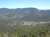
Pinos Altos

Next: Adams’ escape and some famous landmarks
 

Oroblanco

Gold Member
Jan 21, 2005
7,837
9,826
DAKOTA TERRITORY
Detector(s) used
Tesoro Lobo Supertraq, (95%) Garrett Scorpion (5%)
Sdcfia just want to say that you have been posting some great posts, "like" was not a strong enough statement. :thumbsup: :notworthy: Please do continue;

:coffee2: :Coffee2:
 

motel6.5

Sr. Member
Mar 27, 2012
355
367
Nevada,Calif.,Utah,Arizona
Primary Interest:
All Treasure Hunting
The name I have for the German is Emil Schaeffer, made it back to Germany. This may or may not be true. Another version I read stated the Germans body was found with his horse years latter without a name. A Horse with No Name I know was a song by a group whose Name I for-got.
 

OP
OP
sdcfia

sdcfia

Silver Member
Sep 28, 2014
3,650
8,867
Primary Interest:
Other
Sdcfia just want to say that you have been posting some great posts, "like" was not a strong enough statement. :thumbsup: :notworthy: Please do continue;

:coffee2: :Coffee2:

Thanks Oro - I appreciate the complement. I know you have a long standing interest in the LAD, as I do.
 

Mar 2, 2013
729
1,825
Primary Interest:
All Treasure Hunting
I contacted Jack Purcell regarding his definitive book on the LAD about some questions I had concerning various aspects which, for me, did not sit quite rightly. He, to date, has made the most thorough attempt to get to the bottom of this intriguing mystery.

Personally, I am no expert on mining, geography, topography or history. I only came across this story through my interest with all things Chiricahua Apache. I believe the value of the site was played up in later years to attract investors and attain coverage. There is no denying that the basic elements are real and evidenced enough. I cannot accept that the mighty Nana, sub-chief of the Chihenne Apache played the role he has previously been attested to. There are many reasons for this. My belief is that the original site was not as rich as first suggested and might have played out quickly and the group attempted to do a little scouting near where they had originally stopped and the mysterious 'Dutchman' (in all likelihood Snively) had obtained his share and then left, they, the group that is, tried to make a camp to work the richer site which was originally mentioned by their guide. They were probably killed by Apaches and some got away. Perhaps when Adams in later years made a greater emphasis to try and find the container of gold buried under the fireplace/hearth, he knew that they had retrieved much of the placer which was available. Maybe Purcell was quite correct in his assumption that Brewer returned many years later and quietly left for Mexico where he was evidently a rich man, and that he had found what was buried. There was probably plenty of hyperbole involved when describing the site, but obviously it was a decent find that enriched some pretty quickly.

In the last decade of the heroic, yet ultimately futile Apache resistance in which old Nana, Chihuahua, Juh, Geronimo, Victorio, Naiche, Kayatennah, Mangus and the rest played their part (1876-1886), they understood and valued gold as much as anyone and were absolutely desperate to retrieve it to buy ammunition, horses, supplies etc..
They would have collected any such available gold had they had the opportunity. Old Nana didn't pass away until 1896, there was plenty of opportunity for folks to talk to him whilst he was in captivity. When Geronimo and Naiche were asked about the most favourable locations for finding gold, Naiche replied he knew of some locations in the Sierra Madre mountains that Cochise had as a winter camping ground. Geronimo replied that he knew of some spots in the Guadalupe mountains on the Texas border side in the US southwest. They really had nothing to lose then. The Pima, Papagoe and Navajoe scouts - even the Apache scouts later on - had no affinity towards the renegade Chiricahua and would easily have given up the site had it been a popular and well known one to the native people.

Sdcfia is very practical in his observations in that it was more than likely a site that was mined under a different name and the location was discovered in the past. Even Adams played up the gold pot in later years as oppose to the site itself and perhaps this is a small indication that he knew that the location was not as rich as first made out and was more or less played out.

An intriguing story and saga nonetheless.
 

Last edited:
OP
OP
sdcfia

sdcfia

Silver Member
Sep 28, 2014
3,650
8,867
Primary Interest:
Other
I contacted Jack Purcell regarding his definitive book on the LAD about some questions I had concerning various aspects which, for me, did not sit quite rightly. He, to date, has made the most thorough attempt to get to the bottom of this intriguing mystery.

Personally, I am no expert on mining, geography, topography or history. I only came across this story through my interest with all things Chiricahua Apache. I believe the value of the site was played up in later years to attract investors and attain coverage. There is no denying that the basic elements are real and evidenced enough. I cannot accept that the mighty Nana, sub-chief of the Chihenne Apache played the role he has previously been attested to. There are many reasons for this. My belief is that the original site was not as rich as first suggested and might have played out quickly and the group attempted to do a little scouting near where they had originally stopped and the mysterious 'Dutchman' (in all likelihood Snively) had obtained his share and then left, they, the group that is, tried to make a camp to work the richer site which was originally mentioned by their guide. They were probably killed by Apaches and some got away. Perhaps when Adams in later years made a greater emphasis to try and find the container of gold buried under the fireplace/hearth, he knew that they had retrieved much of the placer which was available. Maybe Purcell was quite correct in his assumption that Brewster returned many years later and quietly left for Mexico where he was evidently a rich man, and that he had found what was buried. There was probably plenty of hyperbole involved when describing the site, but obviously it was a decent find that enriched some pretty quickly.

In the last decade of the heroic, yet ultimately futile Apache resistance in which old Nana, Chihuahua, Juh, Geronimo, Victorio, Naiche, Kayatennah, Mangus and the rest played their part (1876-1886), they understood and valued gold as much as anyone and were absolutely desperate to retrieve it to buy ammunition, horses, supplies etc..
They would have collected any such available gold had they had the opportunity. Old Nana didn't pass away until 1896, there was plenty of opportunity for folks to talk to him whilst he was in captivity. When Geronimo and Naiche were asked about the most favourable locations for finding gold, Naiche replied he knew of some locations in the Sierra Madre mountains that Cochise had as a winter camping ground. Geronimo replied that he knew of some spots in the Guadalupe mountains on the Texas border side in the US southwest. They really had nothing to lose then. The Pima, Papagoe and Navajoe scouts - even the Apache scouts later on - had no affinity towards the renegade Chiricahua and would easily have given up the site had it been a popular and well known one to the native people.

Sdcfia is very practical in his observations in that it was more than likely a site that was mined under a different name and the location was discovered in the past. Even Adams played up the gold pot in later years as oppose to the site itself and perhaps this is a small indication that he knew that the location was not as rich as first made out and was more or less played out.

An intriguing story and saga nonetheless.

We all have our biases when it comes to the Lost Adams Diggings. Mine tend to downplay the versions emphasizing the "Brewer-Tenney-Springerville-Wingate-Mormon characters" scenarios, which didn't come to the public's attention until 1928, beginning with Byerts. I know Jack endorsed The First Hundred Years of Nino Cochise (I don't know if he still does), which introduces accounts of the "Mormon players" later in their lives, having relocated to Mexico. The reliability of the Nino Cochise stories has been strongly challenged by many. I could be wrong, but I feel much of that book was fabricated, including the part concerning the former LAD characters. The book was published in 1971, well after the Byerts version and others were known.

It seems Purcell questioned why the Byerts account was so late (sixty years after the events) coming to the table - involving LDS members and territory. He speculated whether there may have been some sort of camouflaging of events resulting from the Mountain Meadows Massacre and the mystery of John D. Lee's secret silver mine. Possibly unknown events were rebranded and spliced into the LAD legends for some sort of damage control. I don't have much of an opinion about it one way or another. The reason I downplay these versions of the LAD story is because of logistics and geology.

I agree that the Apaches knew the value of gold and traded with it whenever they could manage to. As I mentioned in an earlier post, it was reported by Cozzens that in the 1850s Mangas Coloradas had a gold mine of his own somewhere in the Gila headwaters region. A logical choice for this location would be in the Pinos Altos-Santa Rita vicinity, where much gold was later mined. Regarding what the Apaches told Anglos about rich gold mines here and there - I don't put much faith in any of their tales. Frankly, Apaches tended to be very accomplished liars when dealing with Anglos. They weren't stupid. Why divulge this sort of information? They were screwed by Mexicans for years and also by Anglos for years. They knew the score.

I also support your idea that the Adams Diggings was likely rediscovered by others and worked out. My contention is that the diggings were in Bear Creek, which were first discovered by Snively in 1860, reworked by the Adams party - led by Snively, IMO - in 1863, and relocated by the original Pinos Altos miners in 1864 when the reduction in Indian trouble allowed them to return. The claims were patented in 1866, and worked empty during the remainder of the 19th century, for the most part. I don't believe that these golden sands are still waiting for a lucky pilgrim - I believe they were totally exploited a hundred years ago.

Now, the richer diggings above the placer deposit - that's another story altogether. Local legends centering around "dos piloncillos" are much more interesting than the Bear Creek placers - rich as they were in the 1860s. That's a topic for another thread.
 

Oroblanco

Gold Member
Jan 21, 2005
7,837
9,826
DAKOTA TERRITORY
Detector(s) used
Tesoro Lobo Supertraq, (95%) Garrett Scorpion (5%)
The name I have for the German is Emil Schaeffer, made it back to Germany. This may or may not be true. Another version I read stated the Germans body was found with his horse years latter without a name. A Horse with No Name I know was a song by a group whose Name I for-got.

Wow - Emil Schaeffer - sometimes you amigos surprise me (in a pleasant way) as I did not think anyone had turned up that name besides me! I don't know whether to believe Schaeffer was the Dutchman of the story or not, but he is another good candidate.

This is just OPINION but one has to wonder, if the placer were nearly played out, one might think the Adams party was in the process of packing up/finishing up to leave, yet in contrast Adams spent years hunting for the mine, only later focusing on the pot/cache, which makes sense as physically we get older the hard work of mining might look very much less attractive. <Actions speak louder than words>

The Bear Creek placer is a good candidate for the idea of the mine being found and worked out under a different name. Jack Purcell is a member here on T-net (HighMountain) and might be coaxed into joining the discussion. Richard French is also a member here (author of Four Days from Fort Wingate and a new book) so with a little luck we can get them to join in. I may have offended Mr French by my skeptical post in another thread, which I regret as I think he is a very good writer (I love his book Four Days-Wingate) but perhaps he can overlook that.

Have to agree on how much credence we can put in some of the later sources we have. I am of the opinion that the oldest sources (being closest to events) are usually the most reliable, for there is less time and opportunities for errors, misconceptions, deliberate falsehoods and worst of all mixing of different unrelated stories to have occurred. The oldest versions I could find of the Adams story are missing much of the later details, and has the only other survivor as a man named Davison or Davidson, whom unfortunately did not recover and died shortly after the two men were picked up by a cavalry patrol. Most of you have figured out that fort Wingate did not exist in the time span when the Adams events really occurred, but (again referring to the older versions) the fort is not actually named so could have been Ft West or even another fort entirely. To further confuse things there is a second lost Adams mine story that has been mixed together, involving an Indian trader named Henry Adams and a hard rock (lode) inside the Navajo reservation. Henry Adams did go in to Fort Wingate too and showed his gold quartz to several people there, as his story occurred when Ft Wingate did exist. But even the name Sno-ta-hay is Navajo, at least that is what a Navajo friend told me, and he insisted that it is not really a proper name, more like a sentence similar to the popular understanding of 'there it lies' or 'there it is'.

I am getting carried away here but I am not even 100% convinced that the Indians of the massacre (Adams party) were Apaches at all. The Navajos were at war with the US until the treaty of 1868, and were certainly capable of such attacks; they also were known to range well outside the area we think of as Navajo today, and some of the Apacheria had only been recently 'conquered' by Apaches. Nana's story includes a mention of a particular sub-tribe of Navajos that are almost extinct today, and their homeland was well outside the modern Navajo reservation boundaries which I thought was rather interesting. Usually the Navajo links are overlooked or ignored by most LAD hunters. Trying to sort out the things which have gotten mixed in is quite a task today. :BangHead:

Sorry for the diversion there, please do continue, some great posts so far! :notworthy:

Oroblanco

:coffee2: :coffee2:
 

Last edited:

alaskabill

Jr. Member
Jan 5, 2009
81
13
Alaska
Detector(s) used
White's GMT
This is a fastening thread! But so far, no one has suggested that the Bear Creek location fits any of the "clues" reported on the Adams Route maps.. unless I am having another "senior moment". Has this point been discussed in another thread? I agree that documented historical evidence suggests that Bear Creek is the logical location for the LAD, but do the pumpkin patch, rock house, "little door", zig zag canyon, big square rock, etc. fit into this area as well as the location that Dick French reports in his latest book?

There is one issue, however, that give me pause about Dick's "Return to the Lost Adams Diggings": I cannot find any "waterfall" upstream from the places that the Adams party worked. Having not been to the location, I can only rely on topo maps and GoogleEarth. Neither source shows terrain that suggests a geological structure that might have supported a waterfall in the 1860s..... unless the "waterfalls" were created by temporary debris created and collected during a local flood and was later washed away by another. If the latter circumstance was the case, perhaps this "discrepancy" can be explained.

Has anyone been able to match the reported Adams map clues to a possible route into and in the vicinity of Bear Valley?
 

OP
OP
sdcfia

sdcfia

Silver Member
Sep 28, 2014
3,650
8,867
Primary Interest:
Other
Adams Escape Route:
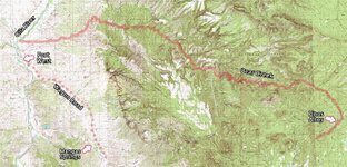
The route that Adams, and possibly a companion, followed after the Apache attack is one of the easiest parts of the LAD puzzle to figure. From the speculated location of the Adams placers on Bear Creek, it makes perfect sense that the survivors followed the same canyon downstream approximately twenty miles to the Gila River. They likely knew that once they reached the river, Fort West would be nearby, since the prospecting party crossed the wagon road leading to the fort near Mangas Springs (the “pumpkin patch”) on their trip into the diggings some weeks earlier. Also, some of the miners had been sent to the fort from the diggings for supplies - these men knew the way but were killed by the Apache on their return trip to the diggings. The map below summarizes the landmarks and escape route.

escape route.jpg
Adams escape route


Malpais
Aka "bad country". This is usually assumed to mean a basalt lava flow, such as the Mount Taylor flow that lies generally east of the Zuni Mountains and west of Highway 114 in the Grants NM area - now the El Malpais National Monument. This is one of the anchor clues in the LAD versions that place the diggings somewhere westerly of Magdalena NM and easterly of Springerville AZ, and strongly tied to Fort Wingate, the “fort in the malpais”.


Many will object, but I'm ignoring the malpais reference. I generally reject the later versions of the LAD legend in lieu of the earlier tellings, and I also reject the malpais reference and its implications. I have spent a fair amount of time in this part of New Mexico trying to reconcile the Byerts et al versions of the legend to the terrain, and it just doesn't work for me. First, there is no gold in the area. That doesn't bode well. Second, it's too damned far from the Pima Villages. Third, it's too far from the Apache's primary venues. I suspect the reference was added solely to bolster a northern location for the diggings - for whatever reason. Obviously, I favor a southern location.


Dos Piloncillos
The two peaks appear in nearly all versions of the LAD legend, older and more recent ones. The Adams party’s guide pointed to the peaks from a high position as they began their final approach to the diggings. Many LAD versions place the peaks beyond the placer deposit, and some allude that the peaks were the source of, or were close to, a much richer gold source. The peaks were referred to as “dos piloncillos” - a reference to the cone-shaped lumps of hardened brown sugar common in the day (and today too, in certain places).


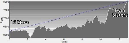
It’s likely that Twin Sisters Peaks, on the Continental Divide northeast of Pinos Altos, were the dos piloncillos. They are twin cone-shaped peaks and well-known landmarks in the region, visible for miles from several directions. The Adams party would have been shown the peaks from the head of Blacksmith Canyon, which they climbed from Mangas Springs to LS Mesa, as shown in a previous post. From this location, the peaks are visible on the horizon to the east, about thirteen miles away. From the suspected location of the diggings in Bear Creek, the peaks would have been accessible by traveling upstream a few miles, then climbing one of several possible routes to the top - about a 2,000 foot elevation gain. Below is a line-of-sight profile from LS Mesa to Twin Sisters.

Blacksmith to TS.jpg
Analysis using Maptech


To sweeten the deal, there are several rich mine/lost treasure traditions in close proximity to Twin Sisters. They are not associated directly to the events of the Adams party except by vague reference in the stories and won’t be expounded on here. Interestingly, the horizontal rock structure connecting the peaks was a view point for Adams at the beginning of later efforts by him and others trying to return to the placer diggings.

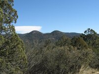
009.JPG
Approaching Twin Sisters from the west
 

Last edited:

Top Member Reactions

Users who are viewing this thread

Top