Cubfan64
Silver Member
- Feb 13, 2006
- 2,986
- 2,789
- Detector(s) used
- Fisher CZ21, Teknetics T2 & Minelab Sovereign GT
- Primary Interest:
- All Treasure Hunting
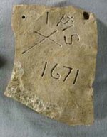
SFNM - I haven't seen any updates on the April get together you had scheduled in the mountains. Did you have any luck sharing your sites and proving you were right about finding the LDM??


")

")