Legends, Maps, Coincidences, Logic, and Hunches.

OP
OP
EE THr

EE THr

Silver Member
Apr 21, 2008
3,979
38
Central California
To the "alignment" map excerpts in post #57, I'm adding a portion of the Virgil Bowman map. And, since it also contains what may be a cave, it should be included in post #46, as well. What looks like a bird head, is also in a position similar to those in #46.

VB Map Excerpt 1.jpg


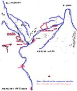
Here is the full map. I think the entire map is a composite of two sections of the Supers, the part I took out, above, being a "blowup" of the target area, and the rest being of the overall Supers area of interest.

treasm10 Virgil Bowman Map 1980.jpg

I suspect that the whole map also contains extraneous markings and symbols. These may be meaningful, or may be mere distractions, or some combination of both.

:coffee2:
 

OP
OP
EE THr

EE THr

Silver Member
Apr 21, 2008
3,979
38
Central California
And, speaking of alignments, specifically Weaver's Needle with Four Peaks, here is a "cleaned up" version of the Virgil Bowman map. It's just the lower portion, without the "blow up" scene in the upper left corner, which I posted above.

I removed symbols which I wasn't sure of. Either I don't know what they mean, or don't know if they are in the right places, even if I did know what they mean. I also removed lines which didn't seem to make sense.

As I stated before, I realize that not all hand drawn maps end up to scale or in proper perspective. And this can be for several reasons, some of which are perfectly valid (at least to whoever is drawing the map). Things can be turned around to better identify them from the different view than they should normally appear. Things can be in the wrong place, either to relate them to another landmark, or just because the person has no sense of proportion. Or the person drawing can't remember correctly or is simply mistaken. Or it could be on purpose, because who wants to be carrying around a map that could lead someone else to his precious treasure site?

A person might even add some strange symbols or trails, streams and canyons that are wrong, just to prevent someone from trying to read it. Who knows?

So here is the Virgil Bowman map, with only what makes sense to me.

VB Map Lower Excerpt Clean.jpg


This could actually be in two parts, the left and the right. What I see, from left to right, is Superstition Peak, the ORO symbol, Miner's Needle, Weaver's Needle, a small symbol for Weaver's Needle with a curved arrow indicating the location where it pertains, a mine symbol with the Four Peaks behind it, Tortilla Creek, and the Sun symbol indicating East.

Since Miner's Needle is positioned to the West of Weaver's Needle, which is wrong, I think the three-landmark group on the far left might be "it's own" map, to show that this is the Supers, and to generally orient things.

Then the portion on the right would be just to show the alignment of Weaver's and the Peaks. Plus the little Needle symbol and it's arrow would be saying, "This is viewed from here."

So in this theory, the whole map would actually be at least three maps combined into one.


And here is Miner's Needle.

Miner\'s Needle.jpg


:coffee2:
 

Loke

Hero Member
Mar 24, 2010
589
1,383
Republic of Texas
Primary Interest:
All Treasure Hunting
... and just _why_ should the sun-symbol signify 'east'? It could as easily be south or west ...

Just saying ...
 

OP
OP
EE THr

EE THr

Silver Member
Apr 21, 2008
3,979
38
Central California
Loke---

My take on it is this. Either the sun is there for no reason, or it is there for a reason.

If it is there for a reason, then what are the possibilities?

It could show the sun's position, in order to read shadow signs. But there is no indication of shadow signs being a part of this map. Or it could be saying, "travel in daylight," but that just doesn't seem to be something a map would need to say.

The only other thing I can think of would be to indicate direction.

The only good the sun is, for direction, is to indicate as you said, either West, South, or East. Of these three, the most prominent are West and East, because they are so pronounced. At sunrise and sunset, there is no doubt about these directions (allowing for seasonal drift to the South).

Around midday, how do you know if the Sun is a little to the South, or a little West, or East, if you don't have a compass? So, just offhand, it wouldn't seem practical to use the Sun to represent South.

It would, therefore, seem typical for the Sun to represent either West or East. Since the rays are going only toward one side, this would tend to support the East-West thing, also. People tend to put a North marker at the top of hand drawn maps, and if a South marker is used, at the bottom. A symbol for East, then would usually be put on the right, and with the rays only shining to the left, as it would at sunrise, it makes sense that it would probably be indicating that the right side of the map is East.

No?

:coffee2:
 

OP
OP
EE THr

EE THr

Silver Member
Apr 21, 2008
3,979
38
Central California
Just to round off the "Four Peaks" alignment concept, here are some more maps, in addition to the ones already shown, which include Four Peaks.

treasm23 Gonzales Mexican Mine Map.jpg

treasm58.jpg

treasm40 Charles Clark Map.jpg

treasm13 Dick Holmes Map.jpg


The first two look very much like one is probably a copy of the other. But the other two seem to be from different sources. So it's more like only three maps, which tend to corroborate the alignment concept.

:coffee2:
 

OP
OP
EE THr

EE THr

Silver Member
Apr 21, 2008
3,979
38
Central California
Here is an additional map which shows the Four Peaks, and has some relative alignment. Note that this map is dated 1892, the same year as Julia's map, one year after Waltz's death.

treasm42 Barks Map 1892.jpg


:coffee2:
 

Nov 8, 2004
14,582
11,942
Alamos,Sonora,Mexico
Primary Interest:
All Treasure Hunting
Good afternoon EE: you posted-->Around midday, how do you know if the Sun is a little to the South,
or a little West, or East, if you don't have a compass
***********
Easily, with several twigs.

Don Jose de La Mancha
 

OP
OP
EE THr

EE THr

Silver Member
Apr 21, 2008
3,979
38
Central California
RDT---

I should have included: "or a watch."

Can you do it without that? At a glance, without tracking the shadows over time?


I also should have added that even on a overcast day, you can usually tell about where the sunrise and sunset are.


:coffee2:
 

Blindbowman

Bronze Member
Aug 15, 2007
2,042
978
Primary Interest:
All Treasure Hunting
Real de Tayopa Tropical Tramp said:
Good afternoon EE: you posted-->Around midday, how do you know if the Sun is a little to the South,
or a little West, or East, if you don't have a compass
***********
Easily, with several twigs.

Don Jose de La Mancha

drop pendalium
it will give you the true 90 degree with in a 3 hour span , any 3 hours any time .. unless over cast .. then get out of the rain ...lol
 

Oroblanco

Gold Member
Jan 21, 2005
7,838
9,830
DAKOTA TERRITORY
Detector(s) used
Tesoro Lobo Supertraq, (95%) Garrett Scorpion (5%)
EE THr wrote, addressing Real de Tayopa,
RDT---

I should have included: "or a watch."

Can you do it without that? At a glance, without tracking the shadows over time?

Why do you rule that method out? How can we know that is not the method which was employed? It does not require a great length of time, and was a method used in ancient times; we ought not think of things in our modern, run-by-the-clock view of the way life should proceed, in my opinion.
Oroblanco

:coffee2: :coffee: :coffee2:
 

OP
OP
EE THr

EE THr

Silver Member
Apr 21, 2008
3,979
38
Central California
Oro---

It probably was employed back in those days by some people.

The original question was, why did I suppose the sun in the map indicated East. So my reasoning was, as I said, based on the easiest and quickest method being the most prominent, and therefore having greater odds of being the determining factor.

Then RDT has to go smartypants on it, and it kind of got dragged out a little, and lost it's meaning. I would still like to hear his "several twigs" method, though.

And I have no idea what good a establishing 90 degrees with a pendulum would do, however, and I don't want to encourage a long meandering post-to-nowhere to find out.

Do you have any idea?
 

BenThereDoneThat

Sr. Member
Feb 27, 2008
277
8
Apache Junction, AZ
Detector(s) used
MXT 300 / Javelina Gold Trommel
Primary Interest:
All Treasure Hunting
:coffee2: :coffee2: You have to be almost 3 miles away from this canyon to see Four Peaks framed in the canyon.......So basically if one sit down to draw you the map he would say, Get on the trail from point A to point B...while on the trail look to the north for this canyon (Blue) in the canyon you will find (Red)......! simple map in two parts
 

Attachments

  • MT.jpg
    MT.jpg
    35.4 KB · Views: 1,344
  • Perfil Mapa.jpg
    Perfil Mapa.jpg
    60.7 KB · Views: 1,353

Oroblanco

Gold Member
Jan 21, 2005
7,838
9,830
DAKOTA TERRITORY
Detector(s) used
Tesoro Lobo Supertraq, (95%) Garrett Scorpion (5%)
EE Ther wrote
Oreo---

It probably was employed back in those days by some people.

The original question was, why did I suppose the sun in the map indicated East. So my reasoning was, as I said, based on the easiest and quickest method being the most prominent, and therefore having greater odds of being the determining factor.

Then RDT has to go smartypants on it, and it kind of got dragged out a little, and lost it's meaning. I would still like to hear his "several twigs" method, though.

And I have no idea what good a establishing 90 degrees with a pendulum would do, however, and I don't want to encourage a long meandering post-to-nowhere to find out.

Do you have any idea?

I presume the pendulum trick would be for determining true north, as it is thought this might be the way the pyramids were aligned for instance, so it may be the intended method for aligning the stone maps correctly. I was curious about your reasoning, as to the original question - why the Sun symbol demarks east, as opposed to another cardinal direction? You have reason(s) why you made that connection, and ruled out the sun-shadow idea while acknowledging the holes likely need sticks or rods placed in them for directional shadows, hence the questions. I may be not getting this right, what it seems that you are saying is that they did not use a Sun-shadow for alignment, hence the Sun-symbol designates east? Just trying to understand your reasoning/logic as we are following your line here, not trying to be a smarty-pants - more like dummy-pants. Alignment of the stone maps would seem to be a salient point in making use of them successfully so I want to understand your theory correctly.
Oroblanco

:coffee2: :coffee: :coffee2:
 

OP
OP
EE THr

EE THr

Silver Member
Apr 21, 2008
3,979
38
Central California
Oro---

:laughing7: I don't mind anyone being a smartypants, but as for RDT, it's just part of his charm and charisma anyway.

My reference to the Sun was pertaining to the paper map in post #61. It was Jack who was talking about the stone maps.

Sorry for the mixup. I was relating to someone just walking around, and wanting to know his compass points.

Then you weren't talking about this anyway, but I still don't know how a pendulum would indicate North?

:coffee2:
 

OP
OP
EE THr

EE THr

Silver Member
Apr 21, 2008
3,979
38
Central California
BenThereDoneThat said:
:coffee2: :coffee2: You have to be almost 3 miles away from this canyon to see Four Peaks framed in the canyon.......So basically if one sit down to draw you the map he would say, Get on the trail from point A to point B...while on the trail look to the north for this canyon (Blue) in the canyon you will find (Red)......! simple map in two parts


:coffee2: :coffee2: That sounds reasonable to me. It looks like a good match for the proportions of the needle and the sombrero, too.

I've come across a few of the maps that appear to have the same theme as what your saying, of "this stuff is for the general area, and the other stuff is the scene once you're there."

Very interesting.
 

Oroblanco

Gold Member
Jan 21, 2005
7,838
9,830
DAKOTA TERRITORY
Detector(s) used
Tesoro Lobo Supertraq, (95%) Garrett Scorpion (5%)
EE THr said:
Oro---

:laughing7: I don't mind anyone being a smartypants, but as for RDT, it's just part of his charm and charisma anyway.

My reference to the Sun was pertaining to the paper map in post #61. It was Jack who was talking about the stone maps.

Sorry for the mixup. I was relating to someone just walking around, and wanting to know his compass points.

Then you weren't talking about this anyway, but I still don't know how a pendulum would indicate North?

:coffee2:

See? I WAS getting confused! Thank you for clearing that up for me. The pendulum helps locate north by observing the shadow, much the same as the gnomon (upright) on a sundial. It takes at least a few minutes to be able to mark off a notable difference as the shadow moves, the longer you can afford to wait the larger the difference and easier to get your measurement. The pendulum or plumb bob works good for this in that it is guaranteed to be an accurate vertical to the ground, while a stick may be off a bit and result in error. There are a number of online articles that can explain the various ways to find true north better than I can, such as:

http://www.sunclocks.com/pics/fs-012.htm
http://www.docstoc.com/docs/33359904/Finding-North
http://www.bisque.com/tom/transitfiles/transit.asp

The way that I know, you must be doing your check around the middle of the day (assuming you have no watch or compass) and will have to keep the plumb bob hanging long enough for noon to pass; by simply marking the length of the shadow and scratching a line or using a twig to mark the line cast by your pendulum periodically, you then take note of the very shortest shadow and corresponding line; the Sun passes the true north-south meridian at local noon everywhere, so that shortest shadow line is then the N-S true meridian with the end farthest away being north. That does not hold true south of the tropic of Cancer, in which case you must know the time of year but we are talking about AZ here.

Oroblanco

:coffee2: :coffee: :coffee2:
 

Loke

Hero Member
Mar 24, 2010
589
1,383
Republic of Texas
Primary Interest:
All Treasure Hunting
*chuckles*
I had just no idea how a simple question could lead to so many posts!
However, I have now learned quite some few things about finding the true north - so I guess my li'l impertinent question might have done some good after all :-)
Usually being in possession of a (working) watch, I have tended to go by any shadows cast at noon. However, being raised at a much larger latitude, I find that a noon shadow in these parts are a different 'kettle of fish' alltogether. Oh - and let us not forget the polar star - I have more than once had to set my course by _it's_ position!
 

OP
OP
EE THr

EE THr

Silver Member
Apr 21, 2008
3,979
38
Central California
Loke---

Yeah, me too, so thanks for asking about that.

Everything helps!

I was just running my thoughts, anyway. Anyone who has some better thoughts is certainly welcome to voice them too, as far as I'm concerned.

I have my doubts that any one person could ever lay claim to the LDM now, anyway, so if it ever is found for sure, I don't think any one person will be able to benefit much. But having it found would be very interesting, and that's probably all anyone could hope for these days.

There has been a whole lot of historic research done by a few people, and having a location to go along with it would allow that whole story to be rounded out nicely.

Happy hunting, all.

:coffee2:
 

Blindbowman

Bronze Member
Aug 15, 2007
2,042
978
Primary Interest:
All Treasure Hunting
EE THr said:
Oreo---

It probably was employed back in those days by some people.

The original question was, why did I suppose the sun in the map indicated East. So my reasoning was, as I said, based on the easiest and quickest method being the most prominent, and therefore having greater odds of being the determining factor.

Then RDT has to go smartypants on it, and it kind of got dragged out a little, and lost it's meaning. I would still like to hear his "several twigs" method, though.

And I have no idea what good a establishing 90 degrees with a pendulum would do, however, and I don't want to encourage a long meandering post-to-nowhere to find out.

Do you have any idea?

then why ask //?????
 

Top Member Reactions

Users who are viewing this thread

Top