The Peralta Stones

Goodyguy

Gold Member
Mar 10, 2007
6,489
6,895
Arizona
Detector(s) used
Whites TM 808, Whites GMT, Tesoro Lobo Super Traq, Fisher Gold Bug 2, Suction Dredges, Trommels, Gold Vacs, High Bankers, Fluid bed Gold Traps, Rock Crushers, Sluices, Dry Washers, Miller Tables, Rp4
Primary Interest:
All Treasure Hunting
Please excuse me for being ig-norant, But how did the stone maps even come to be associated with Jacob Waltz and his mine (LDM) in the first place? I have never heard of any information revealing that he had made a set of stone maps leading to his mine.

I don't think he even used a map to find his mine, as he reportedly was able to draw one up on paper from memory.
What am I missing here :icon_scratch:

Perhaps Jacob first discovered the stone maps and then used them to find the now famous Lost Dutchman mine. That could explain why he was gone so long (he had to decipher the stones). Not needing them any longer and because of their weight he abandoned them where they were later stumbled upon by Travis Tumlinson :dontknow:


GG~
 

Quinan Bear

Sr. Member
Nov 7, 2008
312
6
Grande Prairie Alberta
I can't say that Jacob found the stones and used them or just found a vein that is in the mountains. I can say that the stones show many mines, over a dozen. One of these mines could be the one that the J.W. found.
I recall quotes said to come from J.W. where he said;
To the North he could see where 4 peaks became one and to the South he could see weaver's needle. He also said that he had to climb a steep ravine to the east, in order to see this.
There was a face on the west side of the canyon that looked into the mine entrance.
The sunset would shine into his mine.
He placed a frying pan in a ledge above the mine entrance.
Three stones in the shape of a triangle, mark the entrance.
He hid the vein that ran 450 feet down the canyon.
He could see the army pass by, but they couldn't see him.


Many of these statements, fit at least two of these mines that are listed on the stones, so it could be part of the mines in the stones.
 

Quinan Bear

Sr. Member
Nov 7, 2008
312
6
Grande Prairie Alberta
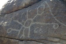
Have you figuered out what is being shown on this Marker ?
I believe that it shows you the course of faults and where gold can be found on them.
 

Attachments

  • Walts map.jpg
    Walts map.jpg
    153.9 KB · Views: 825

Goodyguy

Gold Member
Mar 10, 2007
6,489
6,895
Arizona
Detector(s) used
Whites TM 808, Whites GMT, Tesoro Lobo Super Traq, Fisher Gold Bug 2, Suction Dredges, Trommels, Gold Vacs, High Bankers, Fluid bed Gold Traps, Rock Crushers, Sluices, Dry Washers, Miller Tables, Rp4
Primary Interest:
All Treasure Hunting
This is getting real interesting

pop.gif


Keep em coming guys.
 

Attachments

  • pop.gif
    pop.gif
    16.8 KB · Views: 841
Nov 8, 2004
14,582
11,942
Alamos,Sonora,Mexico
Primary Interest:
All Treasure Hunting
My new friend Bear: for the moment I am going to take your side.

A) No one has had any success in finding the 'Dutchman's deposit or the 'Peralta" thingie, despite over 100 years and multitudes of seekers using the 'existing data'. This leads to the supposition that neither exist, or the data has progressively been misinterpreted. At the moment I tend to believe that it has been incorrectly modified from the original.

Originally it was 'N', then one of the authors or interpreters added 'O'. Some where along the way, one of the many other authors added another interpretation 'N' to explain why the other data didn't have any success in finding the location / s . Finally we now have a multitude of information derived from many means that wasn't available until recently.

This added the 'E' value of today's data = NONE !

Far too many enter the campaign with preconceived, or biased ideas, ideas which are based upon this or that author's ideas of what was meant by the original data, 'if' such ever existed in the first place. Go back to the original data and interpretate it yourself, ignoring all others, if possible. Obviously something is incorrect and has a self sustaining life today.

B) Based upon this, your theory is just as valid as their's, since they have had no success.

C) I must apologize for bringing it up again, but the major failing of the many seekers for Tayopa was in the misinterpretation of the cajon (box canon) on one of the maps to Tayopa. This was supposedly showing an Northern exit from Tayopa when in actuality it is to the south.

This led many to scour the northen regions, particular the Guaynopa / Guaynopita areas.

When one used the available data, it leads directly to Tayopa, but this was never done. The data was twisted to go to the northen area since most were pre-convinced that it lay there.

Another example, one document states that on 7 March viewing from Minaca, the sun sets over Tayopa. It definitely does, but one renowned author twisted this to indicate that the sighting line would run over the Guaynopa area.

It is things similar to this that make your data and interpretations just as valid as any of the others, if not more so.

HOWEVER, it is one thing to know where you must look, and another to actually 'find' the entrance. This why Oro prefers to see some gold which can be identified as matching that coming from the LDM.

Don Jose de La Mancha
 

Cubfan64

Silver Member
Feb 13, 2006
2,986
2,789
New Hampshire - USA
Detector(s) used
Fisher CZ21, Teknetics T2 & Minelab Sovereign GT
Primary Interest:
All Treasure Hunting
Looks like Quinan Bear and SFNM should partner up no? Aren't you living in the area SFNM and going to be having a get together in a few days at your site?
 

Quinan Bear

Sr. Member
Nov 7, 2008
312
6
Grande Prairie Alberta
My views and Mr.New Mexican, have two totally different views and Ideas on how to read the stones.
I have looked at his claims and don't believe him to be right, for the simple reason that the stones were each made to show different mines, not to combine them to make one map.
My views show one stone map at a time with all the markers that is in that stone map, then I go to the next stone map and show all the markers on that map and so on and so forth.
There is a big difference in the way we read the stones. It's up to you if you want to believe or discredit one or both of us. I will however give you the information you ask for.
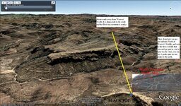
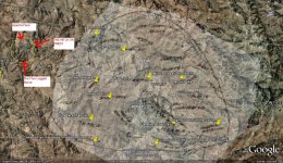
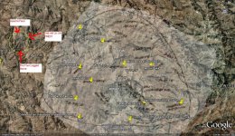
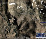
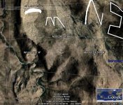
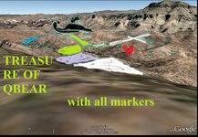
I was asked to show ONE place that would show everything that the stone maps show. well here is the view from Google that shows you all the markers that are on the Priest Map. I didn't outline anything so that it won't be hid by lines that I may put. All you need to do, is look at the Stone map and this pic. I have the most confidence in you all, to see these markers in this pic. The priest is a little stumpy looking in the pic but you must keep in mind that this area covers alot of territory.
If you Don't see all the markers, I will be glad to show you the ones you don't find.
 

Attachments

  • All markers in one spot..jpg
    All markers in one spot..jpg
    157.2 KB · Views: 777
Nov 2, 2009
483
1
But is something else waiting out there too? Something that watches over the mine, or even the mountain itself, waiting for the unsuspecting interloper to dare and trespass on what the Apache believed was sacred ground? Perhaps the prospector named Joe Dearing said it best when he described the mine as “the most God-awful rough place you can imagine... a ghostly place.”

It is certainly a haunted spot. Haunted by an unknown energy that claims the lives of men? Haunted by the ghost of the Dutchman, Jacob Walz? Or haunted by the spirits of the countless men and women whose lives have been taken because of it?
 

Nov 2, 2009
483
1
Quinan Bear said:
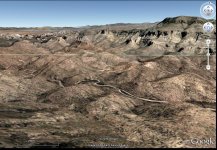
If that's not enough to even raise your attention a little then nothing will. I could show you all the stones but If this one doesn't do anything for you, then why should I show the rest ?
 

Attachments

  • stone_to_real_A.JPG
    stone_to_real_A.JPG
    135.8 KB · Views: 690

Quinan Bear

Sr. Member
Nov 7, 2008
312
6
Grande Prairie Alberta
Before you even ask;
Your wondering why I posted a pic of the priest map and now I'm showing you another Pic. Well the answer is. I wanted to lead you to the place, without revealing the true picture but showing you enough to spark an interest. So now you see the whole picture. The priest is shown, the arm with the cross on the shoulder, the large cross, the small cross, the heart, 2 mines and last but not least 8 N P.
All of this is where it should be, it all can be seen in this pic, exactly as it is on the stone map. What more do you want ?
 

Top Member Reactions

Users who are viewing this thread

Latest Discussions

Top