You are using an out of date browser. It may not display this or other websites correctly.
You should upgrade or use an alternative browser.
You should upgrade or use an alternative browser.
The "Peralta" Stone Maps --- On Their Own
- Thread starter EE THr
- Start date


OP
OP
EE THr
Silver Member
- Thread starter
- #202
Re: The "Peralta" Stone Maps --- On Their Own
Plus....Since the Dotted Trail on the Heart Stone stops, where the two paper maps turn and go northward-ish, stretching things like a cheap bra at a drive-in movie, the Priest Stone does have that 8-N-P notation which some say means 8 (distance units) North, and they thought the P was for paces. Maybe the P is for "Peralta"?
But mainly, maybe it's saying, "At the end point, turn and go North"?
...Just throwing that one out there....

But the other similarities do seem quite coincidental.
Plus....Since the Dotted Trail on the Heart Stone stops, where the two paper maps turn and go northward-ish, stretching things like a cheap bra at a drive-in movie, the Priest Stone does have that 8-N-P notation which some say means 8 (distance units) North, and they thought the P was for paces. Maybe the P is for "Peralta"?
But mainly, maybe it's saying, "At the end point, turn and go North"?
...Just throwing that one out there....
But the other similarities do seem quite coincidental.
Springfield
Silver Member
Re: The "Peralta" Stone Maps --- On Their Own
Ha ha, slow down, Oro. It's just a song, remembering Atlantis and lamenting its passing. I'll wager I'm one of the Atlantis legend's strongest believers here, so climb off please.
When the city of Atlantis stood serene above the sea,
Long time before our time when the world was free,
Those were the days.
Golden cymbals flying on ocarina sounds,
Before wild Medusa's serpents gave birth to hell
Disguised as heaven.
Those were the days, yes they were, those were the days.
Those were their ways, miracles everywhere, where are they now?
They're gone.
Those were their ways, yes they were, those were their ways.
Those were the days, yes they were, those were the days.
Tie your painted shoes and dance, blue daylight in your hair,
Overhead a noiseless eagle fans a flame.
Wonder everywhere.
Those were the days, yes they were, those were the days.
Those were their ways, miracles everywhere, are they now?
They're gone.
Those were their ways, yes they were, those were their ways.
Those were the days, yes they were, those were the days.
Baker & Taylor
Oroblanco said:....Well if this was intended as 'bait' I don't think I will bite. Of course if you would like to have a chance to debate/ridicule Atlantis and-or anyone who "believes" you could start a new thread, just a suggestion of course.

Ha ha, slow down, Oro. It's just a song, remembering Atlantis and lamenting its passing. I'll wager I'm one of the Atlantis legend's strongest believers here, so climb off please.
When the city of Atlantis stood serene above the sea,
Long time before our time when the world was free,
Those were the days.
Golden cymbals flying on ocarina sounds,
Before wild Medusa's serpents gave birth to hell
Disguised as heaven.
Those were the days, yes they were, those were the days.
Those were their ways, miracles everywhere, where are they now?
They're gone.
Those were their ways, yes they were, those were their ways.
Those were the days, yes they were, those were the days.
Tie your painted shoes and dance, blue daylight in your hair,
Overhead a noiseless eagle fans a flame.
Wonder everywhere.
Those were the days, yes they were, those were the days.
Those were their ways, miracles everywhere, are they now?
They're gone.
Those were their ways, yes they were, those were their ways.
Those were the days, yes they were, those were the days.
Baker & Taylor
somehiker
Silver Member
- May 1, 2007
- 4,365
- 6,426
- Primary Interest:
- All Treasure Hunting
Re: The "Peralta" Stone Maps --- On Their Own
Yes,which is why I mentioned it in my previous post.
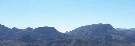
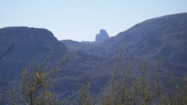
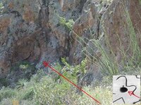
And went to the effort of doing a bit of climbing to obtain these two photos of Weavers.
First from 33°34'10.86"N - 111°20'49.07"W ....the sombrero shaped high point of Horse Mesa
Second,a 5x telephoto, from 33°33'22.79"N - 111°20'56.62"W .... the highest point of Coronado Mesa.
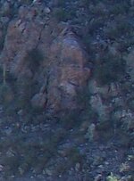
The third is of something below.Another rock which looks like an indian head/face.
The fourth is on a rock face in the area as well.It's not just a small scratching.The distance is about 200 yds.
EE THr said:Oh, yeah....And did you see the "needle" depiction on both the "Unnamed" map and the Heart Stone? That turned out to be the similarity that I had commented about earlier, on my other thread! But I hadn't noticed these other similarities to the Stone Maps at that time.
Yes,which is why I mentioned it in my previous post.
And went to the effort of doing a bit of climbing to obtain these two photos of Weavers.
First from 33°34'10.86"N - 111°20'49.07"W ....the sombrero shaped high point of Horse Mesa
Second,a 5x telephoto, from 33°33'22.79"N - 111°20'56.62"W .... the highest point of Coronado Mesa.
The third is of something below.Another rock which looks like an indian head/face.
The fourth is on a rock face in the area as well.It's not just a small scratching.The distance is about 200 yds.
Attachments
somehiker
Silver Member
- May 1, 2007
- 4,365
- 6,426
- Primary Interest:
- All Treasure Hunting
Re: The "Peralta" Stone Maps --- On Their Own
Yes it do,don't it
EE THr said:SH---
The top one looks just like the one I posted from the letter.
Yes it do,don't it
somehiker
Silver Member
- May 1, 2007
- 4,365
- 6,426
- Primary Interest:
- All Treasure Hunting
Re: The "Peralta" Stone Maps --- On Their Own
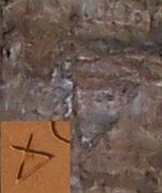
Maybe the "P" is part of something like this...
EE THr said:Plus....Since the Dotted Trail on the Heart Stone stops, where the two paper maps turn and go northward-ish, stretching things like a cheap bra at a drive-in movie, the Priest Stone does have that 8-N-P notation which some say means 8 (distance units) North, and they thought the P was for paces. Maybe the P is for "Peralta"?
But mainly, maybe it's saying, "At the end point, turn and go North"?
...Just throwing that one out there....
But the other similarities do seem quite coincidental.
Maybe the "P" is part of something like this...
Attachments

somehiker
Silver Member
- May 1, 2007
- 4,365
- 6,426
- Primary Interest:
- All Treasure Hunting
Re: The "Peralta" Stone Maps --- On Their Own
From the trail,this is as close as I can come up with so far.
Might be a walled up tunnel
EE THr said:And that would put the "Rock Horse" about where the "Big Hole" is on the Trail Maps. Not having ever been there, though, I have no idea what that might match up with, if anything.
From the trail,this is as close as I can come up with so far.
Might be a walled up tunnel
Attachments
OP
OP
EE THr
Silver Member
- Thread starter
- #209
Re: The "Peralta" Stone Maps --- On Their Own
SH---
I don't know, but, like you pointed out, and as I was thinking, the similarities could indicate a time frame between the Stones and those two maps (I'm including the one which supposed to be one of Julia's because of the Apache Camp thing).
It could be just a coincidence, or rather several of them. But it makes the Stones story seem possibly...fishy.
Joes map puts a "cave?" at or near the Big Hole. But I don't know if there is anything regarding a horse around there or not.
somehiker
Silver Member
- May 1, 2007
- 4,365
- 6,426
- Primary Interest:
- All Treasure Hunting
Re: The "Peralta" Stone Maps --- On Their Own
The natives had many popular campgrounds in the mountains.Pretty much anywhere there was water and food available.I don't think Waltz,himself,ever mentioned an "Apache Camp",but the old army maps show where a few were.Not sure Joe would agree with the term "Apache Camp" anyway.Doubt he would consider any kind of horse,other than what he rode in on,as part of his solution.
Regards:SH.
OP
OP
EE THr
Silver Member
- Thread starter
- #211
Re: The "Peralta" Stone Maps --- On Their Own
SH---
I just saw the picture you posted (you put it up while I was typing my last reply). I've read that there were some that liked to make caliche out of the rock that they were "patching up," so it would look like nothing was there. It kinda looks like that's what your picture is of.
I've seen people mention a horse formation somewhere in there, and I think it was just the head, but I don't know exactly where. There may be more than one.
Nice picture!
somehiker
Silver Member
- May 1, 2007
- 4,365
- 6,426
- Primary Interest:
- All Treasure Hunting

coazon de oro
Bronze Member
Re: The "Peralta" Stone Maps --- On Their Own
I haven't seen sheep sporting a forelock like that.
Homar
somehiker said:This might be one of them.
But it's not part of my solution.
Cubfan thinks it looks more like a Sheephead.
I haven't seen sheep sporting a forelock like that.
Homar
somehiker
Silver Member
- May 1, 2007
- 4,365
- 6,426
- Primary Interest:
- All Treasure Hunting
Re: The "Peralta" Stone Maps --- On Their Own
"I've read that there were some that liked to make caliche out of the rock that they were "patching up,""
I have seen where that has been done.Even where moss or lichen was mixed and used as a fibre reinforcement on vertical surfaces.
"They" also mined lime,cooked it in kilns and ground it to powder in rock mortars,making quicklime for concrete.So much in fact,that the trail by which it was transported over the mountains has extensive patches of broken "cement" where large amounts were spilled during transit.Quicklime is also a potent and long lasting herbicide and growth retardant.Great for making hillside hearts and whatnot.
somehiker
Silver Member
- May 1, 2007
- 4,365
- 6,426
- Primary Interest:
- All Treasure Hunting
Re: The "Peralta" Stone Maps --- On Their Own
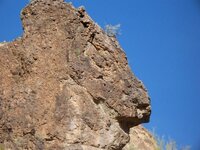
BTW,the rock horse head in the photo above is facing wsw ,as on the JT map.
The shot was taken about 5:30 pm in late Apr.2010.
The peak as shown on the Un-named map,as well as it's duplicate on the Heart Stone is much sharper than what Weaver's Needle is today.
What might this tell us about the age of either map?
OP
OP
EE THr
Silver Member
- Thread starter
- #217
Re: The "Peralta" Stone Maps --- On Their Own
Or, it could mean that it was peaked sharply when the unknown guy made the copy of Julia's map, and tumlinson (or whoever) copied his and Julia's maps.
But then why would Julia's map have it flattened off on top?
Or, it could mean that it was peaked sharply when the unknown guy made the copy of Julia's map, and tumlinson (or whoever) copied his and Julia's maps.
But then why would Julia's map have it flattened off on top?
cactusjumper
Gold Member
Re: The "Peralta" Stone Maps --- On Their Own
Wayne,
Even in the last few years I was going in, I often hiked in or out. Prior to that, I never made the trip on horseback.
For those who like the horse as a big clue, try using Caballo Ojo, Eye Of The Horse, (Aylor's Arch) as a starting point for your drawing. Another little hint from Chuck Aylor?
Take care,
Joe
somehiker said:The natives had many popular campgrounds in the mountains.Pretty much anywhere there was water and food available.I don't think Waltz,himself,ever mentioned an "Apache Camp",but the old army maps show where a few were.Not sure Joe would agree with the term "Apache Camp" anyway.Doubt he would consider any kind of horse,other than what he rode in on,as part of his solution.
Regards:SH.
Wayne,
Even in the last few years I was going in, I often hiked in or out. Prior to that, I never made the trip on horseback.
For those who like the horse as a big clue, try using Caballo Ojo, Eye Of The Horse, (Aylor's Arch) as a starting point for your drawing. Another little hint from Chuck Aylor?
Take care,
Joe
somehiker
Silver Member
- May 1, 2007
- 4,365
- 6,426
- Primary Interest:
- All Treasure Hunting
Re: The "Peralta" Stone Maps --- On Their Own
Morning Joe:
Is there a topo map which has "Caballo Ojo" or "Eye Of The Horse" named on it ?
Can't find "Caballo Ojo" written on any of the Stone Maps either.
Not even on the Stone Crosses or Latin Heart.
Or Abe Ried's Cursum Perficio Rock ,for that matter.
If the hole in Palomino Mtn. was at one end or the other,I could see it being called "Eye of the Horse"...otherwise it sounds more like a red herring hint.
The Aylors had their camp at the bottom of Palomino,which they called "Caballo Camp" (maybe they rode horses?) ,and they spent a fair bit of time digging holes on his Palomino claim below the arch.So Chuck must have thought that the mountain contained gold or something.
Now,if he had spelled the name as "Cobollo",that would have been a "hint".
A good article by Tom K.....http://www.ajpl.org/aj/superstition/stories/The Aylors.pdf
Doesn't mention Tumlinson,stone maps,or DeGrazia though.
If anyone was able to write about such a connection,I would think Tom could.
He has already researched and written about what he knows in several articles.
For me, if what could be a trail was carved or even scratched,from the Horse's eye to somewhere else on the H/P stone,I would only then consider it a possible starting point.
The carved line beginning at the Horse's nose would make a more likely jump off point.
Did Aylor have a hint about the Horse's nose ? Like maybe "the nose knows" or "heh lady,that ain't no banana ! That's my nose !"
Hahchchchchchah
Regards:Wayne
somehiker
Silver Member
- May 1, 2007
- 4,365
- 6,426
- Primary Interest:
- All Treasure Hunting
Re: The "Peralta" Stone Maps --- On Their Own
I think we can be sure, when Tumlinson showed up with the stones,that Weaver's Needle was already quite blunt in appearance.
The "un-named" map likely showed up sometime after the Stone Maps.
EE THr said:Or, it could mean that it was peaked sharply when the unknown guy made the copy of Julia's map, and tumlinson (or whoever) copied his and Julia's maps.
But then why would Julia's map have it flattened off on top?
I think we can be sure, when Tumlinson showed up with the stones,that Weaver's Needle was already quite blunt in appearance.
The "un-named" map likely showed up sometime after the Stone Maps.
Top Member Reactions
-
 2565
2565 -
 1139
1139 -
 1051
1051 -
 903
903 -
 884
884 -
 834
834 -
 817
817 -
 703
703 -
 641
641 -
 527
527 -
 499
499 -
 497
497 -
 490
490 -
 462
462 -
 460
460 -
O
441
-
 420
420 -
 396
396 -
 371
371 -
 360
360
Users who are viewing this thread
Total: 2 (members: 0, guests: 2)