FOUR PEAKS

393stroker

Hero Member
Jun 27, 2012
505
789
HOUSTON
Detector(s) used
Garrett pro-something
Primary Interest:
All Treasure Hunting
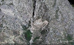
What`s the deal with Four Peaks? I see that it`s mentioned often. Is it a refrence point for the area, a wildlife refuge, or just the biggest thing out there. I found something @ 33*40.342N 111*19.947. I was wondering about any stories about it. Thanks, Chuck 4 PEAKS AREA.jpg
 

Last edited:

vastterrain

Full Member
Sep 1, 2012
109
180
Primary Interest:
All Treasure Hunting
Old Spanish Amethyst Mine is what you refound....think a guy in Scottsdale owns it now....
 

Cubfan64

Silver Member
Feb 13, 2006
2,986
2,789
New Hampshire - USA
Detector(s) used
Fisher CZ21, Teknetics T2 & Minelab Sovereign GT
Primary Interest:
All Treasure Hunting
Old Spanish Amethyst Mine is what you refound....think a guy in Scottsdale owns it now....

I don't believe that's the amethyst mine - unless I'm mistaken, the Amethyst Mine is located about a mile west of the coordinates 393stroker posted (nearer to N33 40.355 W111 19.942). Last I heard, the amethyst mine was owned by a man from New Jersey and his partner from London.
 

somehiker

Silver Member
May 1, 2007
4,365
6,426
Primary Interest:
All Treasure Hunting
Try these co-ordinates....N 33* 40' 16.71" W 111* 20' 00.92"

This video is good.Starts out N/E of Scottsdale and West of the Beeline and goes direct to the mine.


If I get time I will plot the flight path on a topo and post it later.
Or you can find the departure location on G/E and plot your own direct flight to see which mtns and canyons the flight passes over.
Notice how the heli has to climb to clear the last peak (Sheep Mountain).
The white shack is visible in this G/E view.

Regards:SH.
 

Attachments

  • Amethist Mine.jpg
    Amethist Mine.jpg
    367.2 KB · Views: 584
Last edited:
OP
OP
393stroker

393stroker

Hero Member
Jun 27, 2012
505
789
HOUSTON
Detector(s) used
Garrett pro-something
Primary Interest:
All Treasure Hunting
WOW! Thanks for the response`s guys, SH you pulled through for us again. I`m blown away. This made my day. I`m a happy camper. Thanks, Chuck
 

Last edited:

somehiker

Silver Member
May 1, 2007
4,365
6,426
Primary Interest:
All Treasure Hunting
Glad to help Chuck.
That's one mine at least, that you can say you found with Google Earth.:occasion14:
 

Cubfan64

Silver Member
Feb 13, 2006
2,986
2,789
New Hampshire - USA
Detector(s) used
Fisher CZ21, Teknetics T2 & Minelab Sovereign GT
Primary Interest:
All Treasure Hunting
Oops - sorry bout that Chuck. I must have misread the coordinates you posted in the first post - looks like it was the same coordinates as I posted for the Amethyst Mine - my mind must be having problems lately.

Wayne - I'm confused, the coordinates you posted are just west of Black Cross Butte aren't they? By the way - I'm working on seeing if I can make it to the Rendezvous this year afterall, but it will only be for 2-3 days, so no hiking I don't think, but it would be good to see you again if you're going to be there.

Paul
 

OP
OP
393stroker

393stroker

Hero Member
Jun 27, 2012
505
789
HOUSTON
Detector(s) used
Garrett pro-something
Primary Interest:
All Treasure Hunting
Oops - sorry bout that Chuck. I must have misread the coordinates you posted in the first post - looks like it was the same coordinates as I posted for the Amethyst Mine - my mind must be having problems lately.

Wayne - I'm confused, the coordinates you posted are just west of Black Cross Butte aren't they? By the way - I'm working on seeing if I can make it to the Rendezvous this year afterall, but it will only be for 2-3 days, so no hiking I don't think, but it would be good to see you again if you're going to be there.No, you were right. I added an extra #1 in front of the 947. I edited it after.
 

somehiker

Silver Member
May 1, 2007
4,365
6,426
Primary Interest:
All Treasure Hunting
Oops - sorry bout that Chuck. I must have misread the coordinates you posted in the first post - looks like it was the same coordinates as I posted for the Amethyst Mine - my mind must be having problems lately.

Wayne - I'm confused, the coordinates you posted are just west of Black Cross Butte aren't they? By the way - I'm working on seeing if I can make it to the Rendezvous this year afterall, but it will only be for 2-3 days, so no hiking I don't think, but it would be good to see you again if you're going to be there.

Paul

Yes, confusing it was I'm sure...:laughing7:

I'd copied and pasted the co-ords for something else by mistake.....oops.

Should have been N 33* 40' 16.71" W 111* 20' 00.92"

It'll be great if you can at least make the rendezvous.
Sounds like it's gonna be fun.

Regards:Wayne
 

Quinan Bear

Sr. Member
Nov 7, 2008
312
6
Grande Prairie Alberta
Nice video, very informative thanks SH.

I would like to say that i think the four peaks that are mentioned in many stories, are NOT the ones that everyone thinks to be the four peaks mountain. I have studied many USGS maps and found two fault lines that pass just north of black top mesa and the second one farther north, they caught my attention because of the range of stones that are there. I great place to look for minerals. As well, there are three mines that were on the first fault line at one time. I strongly believe that if someone really looked around this area, that they would fine minerals of some kind and a large amount of it. I have added a pic from G.E. and marked what i think are the four peaks as well as the spot that you would be to see them seem like one. This place that is circled has the valley that the fault line passes through and I would think that around that first red hill, would be a vien of minerals. I would strongly suggest looking there.
Come in from the south of the circle and keep to the right side of the canyon, keep an eye out for the change in rock from west to east, this is the fault line, then while heading north, look for a vien of quartz or quartz bearing rock. I would think that the top of that red hill just to the left of the circle, would have signs of man being there in the past.

From a geologist point of view, this would be a place to look... four peaks.jpg

This is just something that i have been keeping in mind since the day that i first started looking for the "stone map" mines.

Just something i wanted to add in responce to your question on the four peaks, hope you don't mind.
 

roadrunner

Bronze Member
Jan 28, 2012
1,230
520
Pinal Mountains,Arizona
Detector(s) used
Garrett Groundhog-2012-1st MD.
White's Goldmaster V/Sat-2nd-MD-2013
Tesoro Lobo-2015-3rd
Primary Interest:
Prospecting
By that picture,or from any picture from GE,how can one see a fault line?
What does a fault line look like?
Guess i better Google it.
Or get a geology book.
 

Quinan Bear

Sr. Member
Nov 7, 2008
312
6
Grande Prairie Alberta
I found the fault line by looking through past USGS databases. They can be seen by anyone looking in the right place.... I found sites that showed the old mines that were found in the superstitions and then covered over or filled. Some old camp sites, old trails and places marking where people were found dead. Just about everything that has gone on in the superstions since the USGS has been studying them.

We have the right to anything that the government has on record after a given time. So if you look in the right places, for the right time, you can find just about anything you want. I have come across some information that was marked out with a black marker but for the most part, i have found what i was seeking.

Some of you might think that i'm just a fool showing what i see on Google earth and don't know anything of value. Because if this, i have only shown you things from google earth.... I know much much more then i am given credit for, but none of you will ever know my full knowledge because you never thought before you acted. Once and awhile i may tell a bit, but only when i feel like it. There is one person that has shown me that he believed that i was onto something and so i did give him some information to go out and verify. I was hoping that i could get a couple guys on here that could really make things happen ( I'm sure you know who you are) to join forces with me and make these mines known and perhaps create a new park that will show them to the people as a means of revenue for the park

I will post a google pic of an area that had at least three mines. I will leave it up to you to verify them. These mines were there and there is a record of them being there. It's up to you to find the information. This way you will show me that you're interested in what i say and at the same time, you will see that i tell the truth.
covered mines.jpg
 

somehiker

Silver Member
May 1, 2007
4,365
6,426
Primary Interest:
All Treasure Hunting
Perhaps it's really the Amethyst Mine at the end of the Stone Maps.
After all it was mined in the 1700's by the Spanish,according to published history, and the gemstones were of such quality that they found their way into the Crown Jewels of a number of European countries.
It may have been important enough to those miners, for them to have made a map to the mine and any caches of gems they had.

David:

The reason you're not likely to get much credit for what you have been posting, at least from those who have been at this for many years, is that they have done the research and discussed and shared what they have found on many occasions. Many have shared their research on these websites for as long as fifteen to twenty years, including links to USGS maps of geological features such as known faulting and mineral resources. Same goes for the BLM maps of the mining claims that were made over the last hundred years or so. Some of the maps of the sups which have been posted on this and the other forums date as far back as 1868 as I recall, and show mines which can't be found on later maps. In addition to those which have appeared on all the different maps, are probably hundreds of holes dug throughout the range by hopeful prospectors. I, and most of the others who have spent a lot of time out there can tell you how easy it would be to spend a whole day looking into old prospects or mines, without travelling more than a mile or two. Especially on and around mountains like Blacktop or Bluff Springs. Even Superstition Mountain itself has seen it's fair share of blasting and pick work. As far as Bluff Springs is concerned, it has received a great deal of attention from LDM searchers, including Glen Magill whose claims above the area you've circled were covered over by the BLM many years ago. It's likely, that if you were able to locate every hole dug in and around Bluff Springs since the Dutchman's day, and stick a pushpin in them all on G/E, you wouldn't even be able to see the mountain any more.....

Is it there ? I can't say if it is or not.
But if you want to read a bit more about what others have said, you can go here.....Lost Dutchman Gold Mine - Arizona Superstition Mountain Wilderness - Gold Mining • View topic - bluff springs nountain

Regards:SH.
 

Quinan Bear

Sr. Member
Nov 7, 2008
312
6
Grande Prairie Alberta
Thanks for the responce SH, I guess i will have to do this with the friends i have here. I am fine with that.
Once and a while i will add a few things on the forum. It is up to you all, if you want to use it or disregard it. It's funny how some people that listen to what i say, send me emails telling me that i was right and they found things where i said they were, but don't want me to say who they are. It's because of them that i continue posting.
 

OP
OP
393stroker

393stroker

Hero Member
Jun 27, 2012
505
789
HOUSTON
Detector(s) used
Garrett pro-something
Primary Interest:
All Treasure Hunting
QB, I hear ya` , It`s virtually impossible to get others to see what we`re looking at sometimes. I believe that Albert Einstinein was quoted saying that" imagination is more important than knowledge".I also think that the markings on the stones are of features that can be seen from certain vantage points, and that secret treasure maps don`t follow the normal paths, but end up where an alternate path would also lead you there. I don`t know much about treasure maps but figure that they wouldn`t want to make it too obvious. Lately I`ve been contemplating the idea of a huge underground cave or cave system that has yet to be found ... Chuck
 

Quinan Bear

Sr. Member
Nov 7, 2008
312
6
Grande Prairie Alberta
QB, I hear ya` , It`s virtually impossible to get others to see what we`re looking at sometimes. I believe that Albert Einstinein was quoted saying that" imagination is more important than knowledge".I also think that the markings on the stones are of features that can be seen from certain vantage points, and that secret treasure maps don`t follow the normal paths, but end up where an alternate path would also lead you there. I don`t know much about treasure maps but figure that they wouldn`t want to make it too obvious. Lately I`ve been contemplating the idea of a huge underground cave or cave system that has yet to be found ... Chuck


Thanks 393stroker;

I spent many hours/years studying the stone maps and will show everyone some day what i found. I will not be discouraged by others because some of you have proven my findings and i know that i will find the last thing on the stone maps that i am missing. That is the "gold Vault", although i know the area, i don't know the exact spot yet. I am within a couple of houndred yards but will keep looking till i'm within a couple of houndred feet.

As for your thoughts on the underground caves....You are correct. They found a cave system they figure runs for thousands of miles and are still exploring it today. the entrance was found a few miles southwest of the grande canyon and they found one exit in the grande canyon. I forget the name of the place but i'm sure you can find it on the net if you look.
 

Cubfan64

Silver Member
Feb 13, 2006
2,986
2,789
New Hampshire - USA
Detector(s) used
Fisher CZ21, Teknetics T2 & Minelab Sovereign GT
Primary Interest:
All Treasure Hunting
They found a cave system they figure runs for thousands of miles and are still exploring it today. the entrance was found a few miles southwest of the grande canyon and they found one exit in the grande canyon. I forget the name of the place but i'm sure you can find it on the net if you look.

Can you tell us who "they" are and whether this is a documented exploration of a cave system?
 

roadrunner

Bronze Member
Jan 28, 2012
1,230
520
Pinal Mountains,Arizona
Detector(s) used
Garrett Groundhog-2012-1st MD.
White's Goldmaster V/Sat-2nd-MD-2013
Tesoro Lobo-2015-3rd
Primary Interest:
Prospecting
There is this one from Wikipedia.
Not sure if this is what he is talking about. But over 60 miles is pretty good.
Az students through in flares and the smoke came out vents in another city.

Qb, i will have look at your area sometime.
I live over here by Queen Valley.
 

Last edited:

Quinan Bear

Sr. Member
Nov 7, 2008
312
6
Grande Prairie Alberta
Can you tell us who "they" are and whether this is a documented exploration of a cave system?

It has been a while since i read about it but i know it was a small town southwest of the grande canyon about 6o miles away. it was found by a man falling through the ground and into the cave. The military put red smoke flares inside and sealed the entrance to see where it would come out and it came out in the grande canyon. Since then they have searched inside and believe that the system is thousands of miles big.

If i come across it again or remember the name, i will post it for you.
 

Top Member Reactions

Users who are viewing this thread

Latest Discussions

Top