LDM why you cant get it ! MAP #33

JackH

Full Member
Feb 26, 2011
211
19
Central Pennsylvania, ex SoCal
Detector(s) used
White's DFX
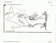
LDM why you can't get it ! MAP #33

1) PICACHO peak of Red Mountain

2) 1-3-2 three (3) Red Hills

3) CASA CAVERNA today hidden under the face of Red Mountain beside the arroyo.

4) ARROYO CAVERNA self explained.

5) MINA & TONEL out cropping and second area mentioned by Waltz nearby.

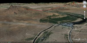
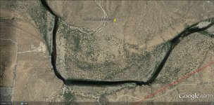
6) NEGRA the range looking down the arroyo S/E at a time of the day (satellite image).
Looking at the first satellite image, 4 Peaks direction comes into question. But Usery Mountain
area at a time of the year casts an unusual shadowing that I cannot repeat today.

7) CERROS COLORADO the range beyond NEGRA (satellite image).

8) RIO SALADO the relationship of Red Mountain & the Salt River approaching from the S/W.
The (satellite image) shows Red Mountain & the Salt River in a similar likeness to MAP #33.
I believe the author of this MAP drew the Salt River to duplicate the river bed exactly as we see
it today next to Red Mountain. This is the only place following the Salt that this exists.

additionally:
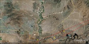
9) AGUA-CAMINO the Ancient channel (?).

10) RIO COLORADO the Verde River in relation to Red Mountain and 90 deg. angle coming to the Salt.

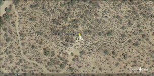
11) MINAS (between (3) & (5) could explain the pockets of the Bird outcropping ?

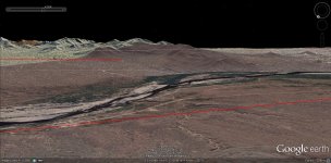
There are a few places along the ridge face right of the arroyo that might explain more of this MAP.


Attachments

  • MAP #33 red pencil (8).jpg
    MAP #33 red pencil (8).jpg
    494 KB · Views: 306
  • approach from SW.jpg
    approach from SW.jpg
    258.4 KB · Views: 209
  • NEGRA and range beyond.jpg
    NEGRA and range beyond.jpg
    212.3 KB · Views: 177
OP
OP
JackH

JackH

Full Member
Feb 26, 2011
211
19
Central Pennsylvania, ex SoCal
Detector(s) used
White's DFX
It has come to my attention that there are at least 2 hand writings
on MAP #33. I think we can all agree that with more than one
person's thoughts, that can give chance for more errors.

I have come back to make a more direct Point of Rio Salado and
the intention of the MAP maker. I have come to make two points
here, but always leading back to Red Mountain.

1) The wide swath of the Salt's river bed has most likely changed
it's course a few times within the last 2 millenniums (2000 yrs.)
nearest Red Mountain. And the intention of the MAP makers to
render the Salt as they have in #33. The only place along the Salt
that reflects this.

Additionally, CAMPO MAYOR above (8) shows small squares within
a box, within a larger outline. Could the outline be a natural boundry ?
If it does, this closeup shows a 10 ft. square on the proper side of the
Salt.

2) It is possible that "Rio Salado" drawn here could actually be the
"Verde River" which has the same swath of a natural river bed and
is Still in close relationship to Red Mountain.

One additional Point, the author's of the MAP, I believe would have
written "RIO SALADO" within the upper and lower boundaries of the
drawn river, not outside. Again for this reason, I believe the MAP
illustrates the wide swath of the ancient river bed.
 

Attachments

  • 11113.jpg
    11113.jpg
    191 KB · Views: 807
  • 11112.jpg
    11112.jpg
    321.9 KB · Views: 208
  • 11111.jpg
    11111.jpg
    327.2 KB · Views: 189
Last edited:

markmar

Silver Member
Oct 17, 2012
4,117
6,259
Primary Interest:
All Treasure Hunting
Hi JackH
I want to tell you about the maps . In the most cases the curved lines not means a river course or a canyon . The words on the maps tell us only the location ( of a river or canyon ) at the specific place . That means how the river or the canyon have a course ( mostly vertically to the curved line ) only near the words . In the most cases the curved lines are land outlines .
And now , I want to tell you how " CASA CAVERNA " seen from afar ( about 0,5 mile ) . Is not a common cave . Is a carved picture on the mountain , and looks like a large horseshoe shaped outcropping of sandstone ( something reminds you ...maybe a " Painted Rock " ) which have in the " mouth " two rock cabins .
Have a nice day

Marius
 

Attachments

  • The cave.gif
    The cave.gif
    163 bytes · Views: 543
  • the cave.gif
    the cave.gif
    202 bytes · Views: 551
Last edited:

peralta

Sr. Member
Sep 28, 2011
389
45
oahu hawaii
Detector(s) used
Whites 2-box
Primary Interest:
All Treasure Hunting
Hello my friends, the pointer does show a mine but look closely, there is a tiny y -tunnel.bottom picture has a heart, search it.what map did you use showing the the house/cavern?
 

OP
OP
JackH

JackH

Full Member
Feb 26, 2011
211
19
Central Pennsylvania, ex SoCal
Detector(s) used
White's DFX
Hello my friends, the pointer does show a mine but look closely, there is a tiny y -tunnel.bottom picture has a heart, search it.what map did you use showing the the house/cavern?

Hello Peralta.

The Map #33 is used in the first post of this Thread.

Which post ? of what you mention "there is a tiny y -tunnel.bottom picture has a heart,"

Jack
 

markmar

Silver Member
Oct 17, 2012
4,117
6,259
Primary Interest:
All Treasure Hunting
peralta

The heart in the map #33 , covers all the region of Mesa Negra . From what point you suggest me to start the search ?

Marius
 

somehiker

Silver Member
May 1, 2007
4,365
6,426
Primary Interest:
All Treasure Hunting
Hi JackH
I want to tell you about the maps . In the most cases the curved lines not means a river course or a canyon . The words on the maps tell us only the location ( of a river or canyon ) at the specific place . That means how the river or the canyon have a course ( mostly vertically to the curved line ) only near the words . In the most cases the curved lines are land outlines .
And now , I want to tell you how " CASA CAVERNA " seen from afar ( about 0,5 mile ) . Is not a common cave . Is a carved picture on the mountain , and looks like a large horseshoe shaped outcropping of sandstone ( something reminds you ...maybe a " Painted Rock " ) which have in the " mouth " two rock cabins .
Have a nice day

Marius

Marius:

And why do you think they drew the little symbol for the Casa Caverna the way they did ?

View attachment 100_1107Casa Caverna.bmp

I think because that is what they could see, when they looked at the cave.

Regards:SH.

PS: Coupla other things in the photo as well.
Look for the word to the right of the opening, which you can also find beside the dot on the Horse Map.
Maybe that's him down below ?
 

Last edited:

peralta

Sr. Member
Sep 28, 2011
389
45
oahu hawaii
Detector(s) used
Whites 2-box
Primary Interest:
All Treasure Hunting
Hello my friend put the picturr on itube ,look to the right youll see an extremely large head of mary looking at your loop.she even has a cloth draped over her htad.the biggest marking I found was about 75feet.none of this is a joke jack.
Take care
Tom
 

peralta

Sr. Member
Sep 28, 2011
389
45
oahu hawaii
Detector(s) used
Whites 2-box
Primary Interest:
All Treasure Hunting
Now maybe people will believe I find areas that have faces .now that stone wall ,look at bottom you have a horseshoe pointing down with a square in the dirt tellin you to fig there. Your loop line has a mine symbol attached.make sure ita not a patt of the plant you would have to check what mary is lookung at.
 

peralta

Sr. Member
Sep 28, 2011
389
45
oahu hawaii
Detector(s) used
Whites 2-box
Primary Interest:
All Treasure Hunting
I found it its a mine symbol ,the circle on the stone.
Good luck
Tom
 

somehiker

Silver Member
May 1, 2007
4,365
6,426
Primary Interest:
All Treasure Hunting
Tom:

I've recieved a few e-mails about things which others see in the photo, including the face at the right.
But you are the only one who believes it's a depiction of "mary".
The word "RIO", where the "O" is part of the "caverna" symbol.
Or...the large letter "M" at the same location.
And a lighter coloured cross to the left of the cavern.
The photo is interesting, but the location is even more so, for my understanding of and belief in the Stone Maps.

Regards:SH.
 

markmar

Silver Member
Oct 17, 2012
4,117
6,259
Primary Interest:
All Treasure Hunting
somehiker

The clue say " a rock cabin in the cave's mouth " and no " a hole in the cave's mouth " .
The picture is interesting . If you believe how the location is connected with the Stone Maps , search around and you may be lucky .

Marius
 

somehiker

Silver Member
May 1, 2007
4,365
6,426
Primary Interest:
All Treasure Hunting
Marius:
To "search around" would be a good idea, I guess. But with so little time it's a difficult proposition, considering how rough the terrain is out there.
It's been worth the effort to do so though, and many of my photos have shown what else is nearby. Insofar as the "rock cabin" clue is concerned,
it's not supposed to have a roof. But it should have a doorway, one would think. Perhaps if you were to enlarge the photo somewhat, you might be able to make out something like that in the cave.

Regards:SH.
 

markmar

Silver Member
Oct 17, 2012
4,117
6,259
Primary Interest:
All Treasure Hunting
somehiker

In your picture , the rock cabin is on the wall of the cave and not match with the symbol in the map .
In the map the symbol show how the rock cabin is in the middle under the horseshoe .
Maybe the same thinking and the monk in your picture .

The monk.jpg

Marius
 

somehiker

Silver Member
May 1, 2007
4,365
6,426
Primary Interest:
All Treasure Hunting
Marius:

It seems obvious that you are looking for something far different than what can be seen in the photo.

View attachment comparison.bmp

If so, perhaps you can post a photo of what it might be.
This photo BTW, is straight from my camera, and aside from being cropped, unaltered in any other way.
It was taken two years ago, from a higher elevation on the opposite side of the canyon, which was necessary to obtain this view.
A monk ? Well, he's definitely not the Priest from the Priest Stone.
Furthermore, he doesn't appear on any of the maps or documents which have been published so far.
So far as I know.


Regards:SH.
 

Last edited:
OP
OP
JackH

JackH

Full Member
Feb 26, 2011
211
19
Central Pennsylvania, ex SoCal
Detector(s) used
White's DFX
Marius:

It seems obvious that you are looking for something far different than what can be seen in the photo.

View attachment 748575

If so, perhaps you can post a photo of what it might be.
This photo BTW, is straight from my camera, and aside from being cropped, unaltered in any other way.
It was taken two years ago, from a higher elevation on the opposite side of the canyon, which was necessary to obtain this view.
A monk ? Well, he's definitely not the Priest from the Priest Stone.
Furthermore, he doesn't appear on any of the maps or documents which have been published so far.
So far as I know.


Regards:SH.

Somehiker,

That is a Great Find. To be following some one's foot prints a couple of Centuries
after those you are looking for, is a magical moment.

Unfortunately for me, all I would have picked up on is the the "Lion" from the Wizard
of Oz in the left side of this photo.......Jack
 

markmar

Silver Member
Oct 17, 2012
4,117
6,259
Primary Interest:
All Treasure Hunting
somehiker

Maybe the place in your picture , is the right place . Enough to match the other clues in the map with this . If have in a short distance to east a creek and a short distance to north-west a mine and a tunel , is the right place .

Marius
 

somehiker

Silver Member
May 1, 2007
4,365
6,426
Primary Interest:
All Treasure Hunting
"Unfortunately for me, all I would have picked up on is the the "Lion" from the Wizard
of Oz in the left side of this photo.......Jack "

Ha :laughing7:....now that you mention it....I can see what you're talking about.
I climbed right up that rock on the way out of there...probably used the nose for a footrest.
 

Top Member Reactions

Users who are viewing this thread

Latest Discussions

Top