Maps

markmar

Silver Member
Oct 17, 2012
4,117
6,259
Primary Interest:
All Treasure Hunting
Don Jose

The " setting sun " clue is an important clue , but don't shows if the mine is on a flat place or on a mountain side .

The clue says : " The setting sun , glitters through a crack in the mountain upon the ore/mine "

So , if you will find the region of the mine but you will can not to recognize the mine , you have to wait the evening to see where is the place which the crack points to . Of course in a 200 feet range ( not 200 yards like the alleged clue says ) from the " roofless two rooms house in a cave's mouth ".
 

Nov 8, 2004
14,582
11,942
Alamos,Sonora,Mexico
Primary Interest:
All Treasure Hunting
Genntlemen. you talk of google earth etc but I see that you are missing the finest tool of all.. I am speaking of aerial photographs. They are not only capable of far finer detail, but also give a true stereo picture. You can get them from the gov't for the entire US, not just the Superstitions With a small stereo viewer you can actualy see things in 3-d

Home in with google earth then when you have a point of interest, go aerial/sat picture/ They are rather inexpensive.

I used them extensively in my search for Tayopa.
 

deducer

Bronze Member
Jan 7, 2014
2,281
4,360
Primary Interest:
Other
Genntlemen. you talk of google earth etc but I see that you are missing the finest tool of all.. I am speaking of aerial photographs. They are not only capable of far finer detail, but also give a true stereo picture. You can get them from the gov't for the entire US, not just the Superstitions With a small stereo viewer you can actualy see things in 3-d

Home in with google earth then when you have a point of interest, go aerial/sat picture/ They are rather inexpensive.

I used them extensively in my search for Tayopa.

US government aerial photography
 

sdcfia

Silver Member
Sep 28, 2014
3,657
8,880
Primary Interest:
Other

Hal Croves

Silver Member
Sep 25, 2010
2,659
2,695
Has anyone actually seen a copy of Carte levee par la Sociente des Jesuites dediee on Roi d'Espagne en 1757?
 

Azquester

Bronze Member
Dec 15, 2006
1,736
2,596
Primary Interest:
All Treasure Hunting
Has anyone actually seen a copy of Carte levee par la Sociente des Jesuites dediee on Roi d'Espagne en 1757?

Hal, I would like to see a copy of it in Mowry's book as it's in Mexican archives probably not available. Copies are in Mowry's book, ($80-$200) but, I haven't seen one, unless one's in the Archives of the Indies in Seville, Spain, and even more inaccessible. If you have one please post it under the "pain from Spain".
 

gollum

Gold Member
Jan 2, 2006
6,729
7,596
Arizona Vagrant
Detector(s) used
Minelab SD2200D (Modded)/ Whites GMT 24k / Fisher FX-3 / Fisher Gold Bug II / Fisher Gemini / Schiebel MIMID / Falcon MD-20
Primary Interest:
All Treasure Hunting
Hal, Bill, and Senor Guacamole,

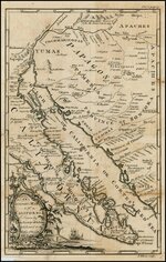
The map Hal is referring to is better known as the "Venegas Map of 1757". It was drawn by Father Mauel Venegas SJ for the King of Spain. Here is a good sized image:

Venegas Map 1757.jpg

(keep clicking, as it gets HUGE)

For Senor Guacamole,

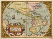
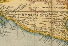
Check out this screenshot from The Ortelius Map of America from 1572:

Ortelius1572insert.jpg

You may notice a couple of interesting things on it;

1. In the upper left area colored yellow, you will see an interesting name: "Astatlan" (kind of similar to Aztlan, huh?). THIS Astatlan lies somewhere in Northwest Mexico or far Southwest US, but it appears to be Southeast of the Colorado River.

2. Just below the "N" in "HISPANIA" (also in yellow area) is a name you might recognize; "TOPIRA"

3. And on the big map below, you can see that Quivira is West of the Colorado River!

Here is the complete map:

Ortelius1572small.jpg

Mike
 

Last edited:

Hal Croves

Silver Member
Sep 25, 2010
2,659
2,695
Hal, Bill, and Senor Guacamole,

The map Hal is referring to is better known as the "Venegas Map of 1757". It was drawn by Father Mauel Venegas SJ for the King of Spain. Here is a good sized image:

View attachment 1312123

(keep clicking, as it gets HUGE)

For Senor Guacamole,

Check out this screenshot from The Ortelius Map of America from 1572:

View attachment 1312140

You may notice a couple of interesting things on it;

1. In the upper left area colored yellow, you will see an interesting name: "Astatlan" (kind of similar to Aztlan, huh?). THIS Astatlan lies somewhere in Northwest Mexico or far Southwest US, but it appears to be Southeast of the Colorado River.

2. Just below the "N" in "HISPANIA" (also in yellow area) is a name you might recognize; "TOPIRA"

3. And on the big map below, you can see that Quivira is West of the Colorado River!

Here is the complete map:

View attachment 1312141

Mike
gollum,
Two things if you don't mind. First, I would appreciate your help in translating "Carte levee par la Sociente des Jesuites dediee on Roi d'Espagne en 1757".
Second, just how certain are you that these are the same maps? Captain Stone copied the original and the map that you posted was created by J Gibson, engraver.

"The notes referred to above contain the names and localities of more than a hundred silver and gold mines which were worked with great success by the Spaniards. The survey of the Jesuit priest about 1687 was repeated in 1710 with renewed discoveries, and consequent accession of population. From this time up to 1757 the conquest and settlement of the country was prosecuted with vigor, both by the Jesuits' Society and Spanish government."

Perhaps its the notes that I should be looking for...

Thanks Mike.
 

Ponteach

Full Member
Feb 1, 2016
106
90
Primary Interest:
All Treasure Hunting
Hal

Carte levée par la societé des jésuites dédiée au Roi d'Espagne en 1757...
( Map ( made by hand ) or if you prefer ( with a Feather pen ) compilated by the society ( or a member ) of the jésuites especially for the king of spain in 1757 ):tongue3:

frenchy
 

Last edited:

gollum

Gold Member
Jan 2, 2006
6,729
7,596
Arizona Vagrant
Detector(s) used
Minelab SD2200D (Modded)/ Whites GMT 24k / Fisher FX-3 / Fisher Gold Bug II / Fisher Gemini / Schiebel MIMID / Falcon MD-20
Primary Interest:
All Treasure Hunting
No worries,

"Carte levee par la Sociente des Jesuites dediee on Roi d'Espagne en 1757"

The closest actual translation I can make is:

"Map (Carte) made/delivered (le`vee) by (par) the (la) Society of Jesus (Sociente des Jesuites) dedicated (dediee) it/to (no) The King of Spain in 1757 (Roi d`Espagne en 1757)

1. Just read the bottom left corner of my Venegas Map:

"An Accurate Map of California Drawn by the Society of Jesuits & Dedicated to the King of Spain 1757"

2. The answer to your second question is easy: YES They are the same map. The original is in Spanish. It was later translated into French and English (and German as well I think).

The Venegas Map is the ONLY map made by a Jesuit in the year 1757, that was meant to be delivered to the King of Spain. Something else you have to keep in mind is that neither the French nor the English had any presence in Nueva Vizcaya. They only made maps of Spanish Territories based on maps already made by Spaniards/Jesuits. So, DuVal, Chatelaine, Mosby, and the rest never saw any of those lands themselves.

Mike
 

Last edited:

sdcfia

Silver Member
Sep 28, 2014
3,657
8,880
Primary Interest:
Other
Just below the "N" in "HISPANIA" (also in yellow area) is a name you might recognize; "TOPIRA"

Topira is interesting. When Coronado and Marcos de Niza embarked together on an exploratory expedition in 1538, Coronado split off east looking for the alleged rich Topira in today's western Durango, NE of Culiacan. He never found it, blaming mountains too rough to penetrate. Marcos continued north on his famous "Seven Cities" adventure, led by Estavanico. There are some very good papers available as pdf downloads that discuss these explorations in detail. Google "Michel Nallino" for Fray Marcos de Niza and the Franciscan Utopia, and A Supposed Franciscan Exploration of Arizona in 1538.
 

Last edited:

EarnieP

Hero Member
Jul 20, 2015
526
1,062
Primary Interest:
All Treasure Hunting
Mike, you're shining like a diamond! Nice posts, great info, thanks.
 

Last edited:

gollum

Gold Member
Jan 2, 2006
6,729
7,596
Arizona Vagrant
Detector(s) used
Minelab SD2200D (Modded)/ Whites GMT 24k / Fisher FX-3 / Fisher Gold Bug II / Fisher Gemini / Schiebel MIMID / Falcon MD-20
Primary Interest:
All Treasure Hunting
Mike, you're shining like a diamond! Nice posts, great info, thanks.

No worries Buddy. I am here to entertain AND educate! HAHAHA

Mike
 

Ponteach

Full Member
Feb 1, 2016
106
90
Primary Interest:
All Treasure Hunting
gollum

I suspect more then your understanding Cajun, but you are not bad at all ...
in the line that Hal ask was ,
"Carte levee par la Sociente des Jesuites dediée on Roi d'Espagne en 1757",
actually there is 3 languages in there, i was thinking that maybe Hal made some mistake in the translation, but this is all ok,
there is first, french, then spanish and English, and then french
the word levée, is use by cartographe for taking traking on the ground, and many more defenitions,
Carte levée par la,.... is french.
sociente, is spanish, in french, la compagnie,
des jésuites, de jésus,
adressé, ( on ), is English,
roi d'Espagne is french,...
i do not know where Hal take this phrase, but the man that wrote it was understanding the 3 languages of americas,

frenchy
 

Hal Croves

Silver Member
Sep 25, 2010
2,659
2,695
gollum

I suspect more then your understanding Cajun, but you are not bad at all ...
in the line that Hal ask was ,
"Carte levee par la Sociente des Jesuites dediée on Roi d'Espagne en 1757",
actually there is 3 languages in there, i was thinking that maybe Hal made some mistake in the translation, but this is all ok,
there is first, french, then spanish and English, and then french
the word levée, is use by cartographe for taking traking on the ground, and many more defenitions,
Carte levée par la,.... is french.
sociente, is spanish, in french, la compagnie,
des jésuites, de jésus,
adressé, ( on ), is English,
roi d'Espagne is french,...
i do not know where Hal take this phrase, but the man that wrote it was understanding the 3 languages of americas,

frenchy
I wrote it as I read it. The report is available online.

Bill, it seems that the "sketch"/ the map was never submitted. Read the foot note.
View attachment 1312474
 

sdcfia

Silver Member
Sep 28, 2014
3,657
8,880
Primary Interest:
Other
SDC, the seven ciudades de Cibola lies in the Conoaqui valley of Sinaloa. It is a national park now.


I know they claim that because most of the north-pushing "Seven Cities" action passed through Sinaloa back in the day. We really don't know exactly what the Seven Cities was/is, but the guys with the information and money were all looking in North America. National Park? Well, they have a UFO Museum in Roswell too, but that only proves the locals know how to turn a buck.
 

Nov 8, 2004
14,582
11,942
Alamos,Sonora,Mexico
Primary Interest:
All Treasure Hunting
SDC, the legend of Cibola was to get the new land explored by way of privately financed expeditions granted certain discovery rights by the Crown at no expense to the crown..Sneaky.

Incidentaly SDC, that valley used the symool of the Buffalo as a religeous symbol, yet there are no Bufalo near there by around 500 to 1000miles. There are literally thousands of figures and carvings of the bufalo. there.

They used Iron pyites ixed with the lime coating on the exterior walls of their houses so that it appears as if they were painted with Gold,

Etc,Etc, fairly convincing evidence.

It is in the interior of Sinaloa, not on the nomal route to the north. I believe that Life did a story on it before WWII

It has many of the features of Cibola
 

Last edited:

Top Member Reactions

Users who are viewing this thread

Top