Maps

azdave35

Silver Member
Dec 19, 2008
3,606
8,104
Thanks azdave,
Yes, the southwestern facing set is marked on GE as well but, not the exact coordinates.
There should also be a second set thou, I am having a difficult time finding it.

It may sound like "pie-in-the sky" dreaming but I think that I now understand their purpose.
I need GPS# to confirm the idea.

i dont think the ones on g.e. are accurate...use the coords on the topo
 

BlackLine

Full Member
Feb 7, 2016
184
401
NRW, Germany
Detector(s) used
Fisher Gold Bug 2
Primary Interest:
Other
I have not.

image.gif
check all photos... if you see it once youll see it everytime and it is important. will explain it shortly
 

Azquester

Bronze Member
Dec 15, 2006
1,736
2,596
Primary Interest:
All Treasure Hunting
Thanks azdave,
Yes, the southwestern facing set is marked on GE as well but, not the exact coordinates.
There should also be a second set thou, I am having a difficult time finding it.

It may sound like "pie-in-the sky" dreaming but I think that I now understand their purpose.
I need GPS# to confirm the idea.

Hal, The first Treasure
(Gold Mine) I discovered utilizing a petroglyph treasure map made on Indian doodles that looked very old. It originally had a crown and cross with the word "ORO" spelled out over it. Some one through time chiseled it off and took it for a rock garden at their home. But the discoverer of the map found it in 1948. It's not in the superstitions but very "similar". Look for large initials like "SE" or similar. Photograph the symbols at twilight holding the camera above your head as if on horseback. Use various colored gel film glasses (Kino Glasses) for seeing the hidden small symbols used to make the larger letters. There you'll find the push-pull symbols like a Spanish Treasure map. (Kenworthy) They made there maps by tallow lantern light so they are only visible at night. I used the various light spectrum's on the photos. Who wants to stay over night near one of these things with a lantern? That's how they made them so discrete. The first Treasure I found was using the glyph's. But the Glyph's I found only took me to the royal campsite high up on a ridge and I had to decode the walkers trail from there. The measurements in the petro=map took me to the exact spot in of the mine but at the time I was more interested in the royal campsite. Still it provided me with a compass direction and a distance to the exact spot in leagues. I forget what the leagues were in miles but they were between 2-3 miles each.

I followed the symbols carved on the other side of the mountain from the Petroglyph which gave me the final momument (Alpha- Omega) to look for at the final map or rock outcrop. I found the back filled shaft (60 feet down) at the spot the original map said it was but since I knew not what leagues they used I had to do it the old fashion way and follow the clues.


View attachment 1357547

Look closely at the left side "SE" letters they are the beginning of the map and it ends at the pozo (Hat) symbol with distance and direction all in very small writing. This map is from the Petroglyph on a large rock and actually shows a smelter location and the gold symbol is the "fist" or Aztec Poop symbol that has a "coc" for gold. There is also a tongue symbol and a hooked "X" style symbol typical of Free Masonry. Notice how they spelled Jesus "Jeas" and made the word "Rosary" out of tiny symbols. This was all gleamed from the Petroglyph. It shows a mountain with a treasure secreted in the side of it at an angle down for the shaft just as I found it. The 600 is actually 60 feet down just where the hydro-geo company located it from the filled shaft. It made there meter jump off the scale. I believe this to be part of Montezuma's treasure Hernan Cortez left here after finding it in a cave. He couldn't take it all with him so he buried some of it.
 

Last edited:

audigger53

Hero Member
Mar 27, 2004
909
3,210
Severn, Maryland
Detector(s) used
None
Primary Interest:
Cache Hunting
BuffaloBob; It is also illegal in Colorado anyway said:
I never kill rattlers for grins, I just teach them to play Catch, with 3-5 LB rocks. After a while, they forget they don't have hands and try to catch them. Then it becomes a tombstone.
 

Azquester

Bronze Member
Dec 15, 2006
1,736
2,596
Primary Interest:
All Treasure Hunting
View attachment 1357259
check all photos... if you see it once youll see it everytime and it is important. will explain it shortly

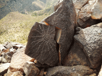
The "13" may contain tiny map symbols in a row. I've seen them in numerals, spirals, and lettering. They made their maps in tiny symbols as most only see the larger symbols when viewing and they knew this. Each leg of the sunburst may have tiny symbols too. This is why you never used chalk to enhance the symbols as you're just covering the true maps. Once you find the the true map symbols you'll know it as they'll have the distance and directions included.
 

Azquester

Bronze Member
Dec 15, 2006
1,736
2,596
Primary Interest:
All Treasure Hunting
I never kill rattlers for grins, I just teach them to play Catch, with 3-5 LB rocks. After a while, they forget they don't have hands and try to catch them. Then it becomes a tombstone.

Same thing with Wood Peckers. Like the ones destroying my cabin. But they ran into an accident. I left out some mouse traps and they seem to have somehow become tangled in the traps.

I wonder why?


View attachment 1357777

(The above photo was faked like the stone maps and isn't real the bird used was a plastic decoy and only resembles a Wood Pecker, no birds were harmed in the making of this photo only a few Squirrel's, Rats, and Bunnys)
 

Azquester

Bronze Member
Dec 15, 2006
1,736
2,596
Primary Interest:
All Treasure Hunting
Speaking of Maps...this is the instrument used at the first site I found with the Petroglyph Map...it has been used for over fifty years to find ore bodies and voids underground down to the 400 foot level. It's highly accurate in the right hands and has been tested and true time again as being the one instrument that tells no lies. I was the first person in Arizona according to the Hydro Geo Company that ever had a "Hit" on a strong target about 60 feet down in all their years of hundreds of geological explorations.

They use a Geonics EM16 for the project which took two full days of mapping off a grid in the area. These can also be utilized by plane for surveys.

View attachment 1357786

A tested instrument that doesn't tell lies.
 

Hal Croves

Silver Member
Sep 25, 2010
2,659
2,695
Hal, The first Treasure
(Gold Mine) I discovered utilizing a petroglyph treasure map made on Indian doodles that looked very old. It originally had a crown and cross with the word "ORO" spelled out over it. Some one through time chiseled it off and took it for a rock garden at their home. But the discoverer of the map found it in 1948. It's not in the superstitions but very "similar". Look for large initials like "SE" or similar. Photograph the symbols at twilight holding the camera above your head as if on horseback. Use various colored gel film glasses (Kino Glasses) for seeing the hidden small symbols used to make the larger letters. There you'll find the push-pull symbols like a Spanish Treasure map. (Kenworthy) They made there maps by tallow lantern light so they are only visible at night. I used the various light spectrum's on the photos. Who wants to stay over night near one of these things with a lantern? That's how they made them so discrete. The first Treasure I found was using the glyph's. But the Glyph's I found only took me to the royal campsite high up on a ridge and I had to decode the walkers trail from there. The measurements in the petro=map took me to the exact spot in of the mine but at the time I was more interested in the royal campsite. Still it provided me with a compass direction and a distance to the exact spot in leagues. I forget what the leagues were in miles but they were between 2-3 miles each.

I followed the symbols carved on the other side of the mountain from the Petroglyph which gave me the final momument (Alpha- Omega) to look for at the final map or rock outcrop. I found the back filled shaft (60 feet down) at the spot the original map said it was but since I knew not what leagues they used I had to do it the old fashion way and follow the clues.


View attachment 1357547

Look closely at the left side "SE" letters they are the beginning of the map and it ends at the pozo (Hat) symbol with distance and direction all in very small writing. This map is from the Petroglyph on a large rock and actually shows a smelter location and the gold symbol is the "fist" or Aztec Poop symbol that has a "coc" for gold. There is also a tongue symbol and a hooked "X" style symbol typical of Free Masonry. Notice how they spelled Jesus "Jeas" and made the word "Rosary" out of tiny symbols. This was all gleamed from the Petroglyph. It shows a mountain with a treasure secreted in the side of it at an angle down for the shaft just as I found it. The 600 is actually 60 feet down just where the hydro-geo company located it from the filled shaft. It made there meter jump off the scale. I believe this to be part of Montezuma's treasure Hernan Cortez left here after finding it in a cave. He couldn't take it all with him so he buried some of it.

Bill,

That tracing/line drawing is incredible. The human looking symbol depicted is amazingly similar to Lenape signature "marks" that I have seen on historical land-sale documents. I took two, signed by native women, and tried to recreate them in 3d with salvaged material for a vision impaired friend. Enclosed is a photograph of both. Strange that they omitted arms (hands tied?). Stranger still that a European would use the same symbolism to represent the human form. But, perhaps early Europeans introduced the idea.

Very interesting example Bill.


Real of Tayopa

Bronze Member
Sep 4, 2016
1,942
9,101
Mexico
Primary Interest:
All Treasure Hunting
AU, yer a mean sob.:laughing7::laughing7: I t wasn't for the poor rattlers we would be overwhelmed with rodents, be coming out of our ears.:
 

audigger53

Hero Member
Mar 27, 2004
909
3,210
Severn, Maryland
Detector(s) used
None
Primary Interest:
Cache Hunting
AU, yer a mean sob.:laughing7::laughing7: I t wasn't for the poor rattlers we would be overwhelmed with rodents, be coming out of our ears.:

There is nothing a Rattler does that a King or Black snake can't do, except King/Black Snakes also eat Rattlers. People use to think that they were mating, and didn't understand that the King snake was strangling the rattler to death.. Wrapping around so the Rattler could not breath.
 

azdave35

Silver Member
Dec 19, 2008
3,606
8,104
There is nothing a Rattler does that a King or Black snake can't do, except King/Black Snakes also eat Rattlers. People use to think that they were mating, and didn't understand that the King snake was strangling the rattler to death.. Wrapping around so the Rattler could not breath.

someone had a pic on facebook a while back of a kingsnake eating a rattlesnake....bullsnakes are also supposed to dine on rattlesnakes
 

Azquester

Bronze Member
Dec 15, 2006
1,736
2,596
Primary Interest:
All Treasure Hunting
Bill,

That tracing/line drawing is incredible. The human looking symbol depicted is amazingly similar to Lenape signature "marks" that I have seen on historical land-sale documents. I took two, signed by native women, and tried to recreate them in 3d with salvaged material for a vision impaired friend. Enclosed is a photograph of both. Strange that they omitted arms (hands tied?). Stranger still that a European would use the same symbolism to represent the human form. But, perhaps early Europeans introduced the idea.

Very interesting example Bill.


Thanks Hal! I believe it represents a sealed Pozo Shaft or covered chamber in their symbol language. But I could be wrong. There is no precedence for these symbols anywhere I've found so it's up to the the one who finds it to try and explain it.

All I can say is the symbols were contained in a petroglyph as I related and very small but still visible with the correct angle, lighting and lenses. They use magnifying lenses to make the symbols in a straight line as part of a larger symbol array as a way to conceal the message. The "Poop" symbol with the "COC" is Aztec in nature. The crown and the word "ORO" are not depicted in here but would lie somewhere in between the "Pozo" symbol and the start of the"JEAS" step map. I made this from what I saw in the small symbols during the examination of the petroglyph photo's. And just to ensure they were not modern I had the original disoovery photo from 1948 to compare with. The photo and symbols were authentic at least back to 1948.

What very interesting in the photo is the 'Hooked X" with a "Y" off to the right. I discovered a central Cactus that had four barrel cactus's in a circle around it and the one depicted to be a "Y" I sighted in with my Bino's and it was a straight line to a large saguaro about two leagues distant. The only large cactus in the whole area. There was small peaked mountain off one of the "X" spines that had a large Christian Cross laid out in rocks right on top of it. Just like the cross depicted with the heart on the top to the right of the map and towards the bottom. I believe there may be other treasures associated with this map but I only went for the one on the left.

Seriously, It looks like the robot from lost in space the first one back in the 60's.

But it could be a humanoid of the early stick people tribe. They all came from an unknown planet called Pozo on the back side of Uranus.
 

Last edited:

somehiker

Silver Member
May 1, 2007
4,365
6,426
Primary Interest:
All Treasure Hunting
Bill,

That tracing/line drawing is incredible. The human looking symbol depicted is amazingly similar to Lenape signature "marks" that I have seen on historical land-sale documents. I took two, signed by native women, and tried to recreate them in 3d with salvaged material for a vision impaired friend. Enclosed is a photograph of both. Strange that they omitted arms (hands tied?). Stranger still that a European would use the same symbolism to represent the human form. But, perhaps early Europeans introduced the idea.

Very interesting example Bill.


I'm old enough to remember that guy Hal.
Is that a good thing ???


Azquester

Bronze Member
Dec 15, 2006
1,736
2,596
Primary Interest:
All Treasure Hunting
Bill,

That tracing/line drawing is incredible. The human looking symbol depicted is amazingly similar to Lenape signature "marks" that I have seen on historical land-sale documents. I took two, signed by native women, and tried to recreate them in 3d with salvaged material for a vision impaired friend. Enclosed is a photograph of both. Strange that they omitted arms (hands tied?). Stranger still that a European would use the same symbolism to represent the human form. But, perhaps early Europeans introduced the idea.

Very interesting example Bill.


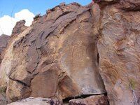
You're right again Hal! I looked up the symbols on rocks and these are what I found that seem similar to what I called a "Pozo".


View attachment 1361092

View attachment 1361093


View attachment 1361094


View attachment 1361095
 

Blglover96

Greenie
Sep 17, 2016
10
1
Primary Interest:
All Treasure Hunting
Im a Newbie to this stuff. I heard a riddle that there's a mine off the cave on peralta trail. If you climb all the way through it there's a mine on the other side. It's says you can see the military road from the mine, but you can't see the mine from the military road and that the sun sets on it. Anybody find this to be true? It says you can see weavers needle a couple hundred yards up which is true.
 

Top Member Reactions

Users who are viewing this thread

Top