Maps

sgtfda

Bronze Member
Feb 5, 2004
2,351
3,887
Mesa Arizona
Im a Newbie to this stuff. I heard a riddle that there's a mine off the cave on peralta trail. If you climb all the way through it there's a mine on the other side. It's says you can see the military road from the mine, but you can't see the mine from the military road and that the sun sets on it. Anybody find this to be true? It says you can see weavers needle a couple hundred yards up which is true.

Sounds like one of Bob Wards stories. Like the mine with steps that went from his shack area over to and under Weavers needle.
 

Blglover96

Greenie
Sep 17, 2016
10
1
Primary Interest:
All Treasure Hunting
Is this story true? How far does the tunnel go? I've gone probably 70 yards into it and my buddy wanted to turn around.
 

azdave35

Silver Member
Dec 19, 2008
3,606
8,104
Is this story true? How far does the tunnel go? I've gone probably 70 yards into it and my buddy wanted to turn around.

the tunnel goes in a few hundred feet...then drops into a shaft that is about 20 feet deep...at the bottom of the shaft is another tunnel that takes you to the front side of the mountain overlooking peralta road
 

Blglover96

Greenie
Sep 17, 2016
10
1
Primary Interest:
All Treasure Hunting
Is the shaft possible to get past? Or do you have to stop straight down it?
 

Blglover96

Greenie
Sep 17, 2016
10
1
Primary Interest:
All Treasure Hunting
What I also meant in that question is it easy to get down? Or would it take some effort to continue past the shaft
 

Blglover96

Greenie
Sep 17, 2016
10
1
Primary Interest:
All Treasure Hunting
Also does the tunnel get larger or does it stay small and claustrophobic the whole way?
 

Blglover96

Greenie
Sep 17, 2016
10
1
Primary Interest:
All Treasure Hunting
The tunnel I crawled through was a foot tall at some points.. Maybe I'm in the wrong hole.... Hehe
 

markmar

Silver Member
Oct 17, 2012
4,117
6,259
Primary Interest:
All Treasure Hunting
What about a different version of the Bulbridge map ? Is in the SWA .

petro map.jpg
 

nobodie

Hero Member
Jul 17, 2015
596
887
Phx. A.Z.
Primary Interest:
All Treasure Hunting
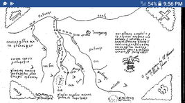
Does anyone know any information about this map? Who was the person that gave it to Celeste Jones? Is it a real treasure or a LDM map. Any history. Thank you.
 

Attachments

  • Screenshot_2017-07-04-21-56-23.png
    Screenshot_2017-07-04-21-56-23.png
    94.5 KB · Views: 160

cactusjumper

Gold Member
Dec 10, 2005
7,754
5,388
Arizona
Does anyone know any information about this map? Who was the person that gave it to Celeste Jones? Is it a real treasure or a LDM map. Any history. Thank you.

The note says Al Morrow gave her the map. I have serious doubts about that.

Good luck,

Joe Ribaudo
 

John_Arizona

Hero Member
Jan 30, 2013
562
708
Arizona
Detector(s) used
Spanish Death Rods
Primary Interest:
Prospecting
Nice going Blackline! Just one thing I see wrong. All those stone maps that were carved from an earlier paper map have been proven to be fabrications out of the mind of one Travis Tumlinson the great hoaxsman of our time. We all fell for it until we were told he faked them. Now, we don't even discuss those maps anymore. Sort of a tabboo subject. You're welcome to show whatever you want just be advised you're using fake treasure maps sold at various novelty shops and tourist dives like the Supertstition Mountain Museum.

what if they weren't fake, and someone just wanted to throw someone off, just a thought... by the way.
 

junkhunt

Sr. Member
Feb 21, 2017
314
349
North Central Arkansas
Detector(s) used
white's eagle spectrum , White's Spectra V3i, Garrett AT Pro. Garrett AT Pen pointer
Primary Interest:
All Treasure Hunting
Are there any Street level pre 1960 maps for the Cherokee Village, Sharp, Fulton county Arkansas? Been looking for a long time with no luck.
 

John_Arizona

Hero Member
Jan 30, 2013
562
708
Arizona
Detector(s) used
Spanish Death Rods
Primary Interest:
Prospecting
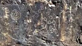
I too have been working on the map of the peralta stones, and took off in a different direction than most on here are/were looking and I found a series of sealed caves. Sorry it's blurred, it was shot from a distance. I will get better photos once it cools down in the Valley.
sealed.JPG
 

nobodie

Hero Member
Jul 17, 2015
596
887
Phx. A.Z.
Primary Interest:
All Treasure Hunting
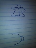
Does anyone know what these symbols on the Celeste Jones map mean? One of you symbols experts might know.
 

Attachments

  • IMG_20170710_231838.jpg
    IMG_20170710_231838.jpg
    348.9 KB · Views: 78

somehiker

Silver Member
May 1, 2007
4,365
6,426
Primary Interest:
All Treasure Hunting
Does anyone know what these symbols on the Celeste Jones map mean? One of you symbols experts might know.

The upper one could be related to the "rock like a man standing" clue.....with a crack up the center...., and the lower might indicate a "single rock on a boulder" type of trail marker IMO.

Regards:SH.
 

nobodie

Hero Member
Jul 17, 2015
596
887
Phx. A.Z.
Primary Interest:
All Treasure Hunting
You might be right about the bottom one. There are 5 of them, pointing in the same direction. Maybe a small rock on a large boulder , a trail marker. That would make sense, thank you. The one that looks like a man at the end of a trail, maybe means to stop here.
 

starman 1

Full Member
Jun 3, 2010
157
305
Hello Nobodie,

Interesting map to say the least. Don Shade indicated on page 103 of his work, "Esperanza", that he used the map to find a mine.

Its history is a bit murky but one could argue its essence is quite telling. Consider the possibility the Salt River and Fish Creek Canyon are shown on the map and the cross on the upper right is indicative of something special.

Next connect the dots between Walter Gassler and Don Shade, and the folks that were there. That trail and this map takes you back to Ruth.

Have a good day.

Starman
 

Top Member Reactions

Users who are viewing this thread

Top