BuffaloBob
Bronze Member
- Jan 6, 2005
- 1,367
- 262
- Detector(s) used
-
Minelab X-Terra 705 Gold Coil
deteknixXpointer Probe
Minelab Ex-Terra 70
White's Classic II
2014-2015 Colorado Gold Camp Prospector
- Primary Interest:
- Metal Detecting
Superstition Mountain History
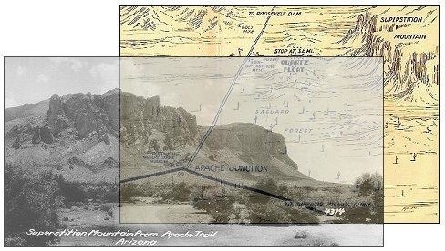
The Superstition Mountain
Courtesy of Tom Kollenborn and the Superstition Mountain Historical Society.
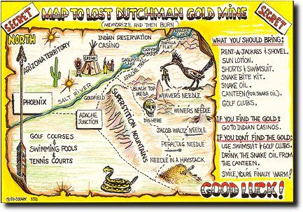
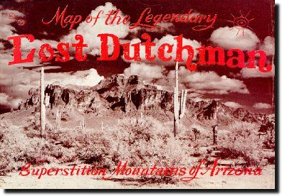
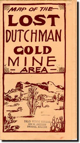
Arizona's Superstition Mountain has long been the source of stories and tales about lost gold. Legends of the Dutchman's Lost Gold Mine, Jesuit treasure, Peralta gold and numerous other lost gold mine stories still attract men and women from far and near alike to this rugged mountain range east of Apache Junction.
Tales of Indian history add to the mountain's lore. These stories are centuries old. The Pima's called Superstition Mountain Ka-Katak-Tami meaning "The Crooked Top Mountain." From the towering summit of Superstition Mountain one can see the vastness of this rugged mountain range to the east . The mountain serves as a dividing line between rural and urban Arizona. As the population of the Salt River Valley grows the lights of Phoenix continue to advance on the realm of the Dutchman's Lost Gold Mine and the Apache Thunder God.
This giant monolith, Superstition Mountain, rises to the height of 3,000 feet above the surrounding desert floor and dominates the eastern fringe of the Salt River Valley. The Superstition Wilderness Area, of which Superstition Mountain is part, contains some 242 square miles or 159,780 acres of Arizona's rugged desert mountain terrain. Mountain peaks tower 6,000 feet above sea level and deep canyon dissect this vast wilderness region.
The region includes a wide-range of fauna and flora that are native to the Sonoran Desert life zone. Plants range from the giant Saguaro cactus to the stately Ponderosa pine. Mule deer, javelinas, mountain lions, bobcats, coyotes, a variety of birds, reptiles and amphibians live in this fragile desert eco-system. The diversity of living things in this region astonishes the visitor.
Old-timers will tell you everything that survives in this desert wilderness either sticks, stings, bites or eats meat. This is an age old description about survival in such a harsh environment. This is a land were life is totally dependent on the availability of water. The desert is a place where water will appear one day and vanish the next day. Temperatures on the desert floor can exceed 125 degrees F in the summer months and can drop well below freezing during the winter months. Snow is not uncommon to the high desert mountains during the winter months.
This land of towering spires and deep canyons was formed by volcanic upheaval some 29 million years ago during the tertiary period of geologic time. Superstition Mountain was formed during a tectonic maelstrom which resulted in a massive caldera. The caldera was almost seven miles in diameter. After the lava cooled, magma pushed the center of the caldera upward forming a mass of igneous rock. The mass was slowly eroded for millions of years by running water and wind forming the mountain we see today. Superstition Mountain in the distant past was a thousand feet higher than it is today. Uplift, subsidence, resurgence and erosion have all played a role in shaping Superstition Mountain. Yes, this mountain was born of fire.
What is the origin of the name Superstition Mountain? The best answer to this question centers around the early farmers of the Salt River Valley who grew and cut hay for the Army at Fort McDowell during the late 1860's. These farmers constantly heard stories from the Pima Indians how they feared this mountain. The farmers thought the Pimas were superstitious about the mountain hence the name Superstition Mountain.
Some authors and writers would lead you to believe the Spanish named Superstition Mountain. Sims Ely, author of The Lost Dutchman Mine, stated in the opening chapter of his classic book on the Lost Dutchman Mine that the Spanish named Superstition Mountain Sierra de espuma meaning a "mountain of foam." The origin of this name appears to be a forest service map drawn by L.P. Landon in 1918. Landon named a small butte southwest of Superstition Mountain Monte de Espuma.
It is true, the first European visitors to this area were Spanish. Fray Marcos de Niza was the first European to see Superstition Mountain in 1539. He observed the mountain from the Gila River during his visit to the region almost five hundred years ago. He did not explore the rugged mountain range or record it in his journal.
Sierra Supersticiones appeared on military field sketch maps of the region as early as May of 1866. This was during the Rancheria Campaign lead by Brevet Lt. John D. Walker's 1st Arizona Volunteers and U.S. Army Infantry from Fort McDowell under the command of Lt. Col. Clarence E. Bennett.. The first United States War Department maps of the region made reference to the Superstition Mountains as the Salt River Mountains. The first time Superstition Mountain appeared on official military maps was in 1870.
The Superstition Mountain
Courtesy of Tom Kollenborn and the Superstition Mountain Historical Society.
Arizona's Superstition Mountain has long been the source of stories and tales about lost gold. Legends of the Dutchman's Lost Gold Mine, Jesuit treasure, Peralta gold and numerous other lost gold mine stories still attract men and women from far and near alike to this rugged mountain range east of Apache Junction.
Tales of Indian history add to the mountain's lore. These stories are centuries old. The Pima's called Superstition Mountain Ka-Katak-Tami meaning "The Crooked Top Mountain." From the towering summit of Superstition Mountain one can see the vastness of this rugged mountain range to the east . The mountain serves as a dividing line between rural and urban Arizona. As the population of the Salt River Valley grows the lights of Phoenix continue to advance on the realm of the Dutchman's Lost Gold Mine and the Apache Thunder God.
This giant monolith, Superstition Mountain, rises to the height of 3,000 feet above the surrounding desert floor and dominates the eastern fringe of the Salt River Valley. The Superstition Wilderness Area, of which Superstition Mountain is part, contains some 242 square miles or 159,780 acres of Arizona's rugged desert mountain terrain. Mountain peaks tower 6,000 feet above sea level and deep canyon dissect this vast wilderness region.
The region includes a wide-range of fauna and flora that are native to the Sonoran Desert life zone. Plants range from the giant Saguaro cactus to the stately Ponderosa pine. Mule deer, javelinas, mountain lions, bobcats, coyotes, a variety of birds, reptiles and amphibians live in this fragile desert eco-system. The diversity of living things in this region astonishes the visitor.
Old-timers will tell you everything that survives in this desert wilderness either sticks, stings, bites or eats meat. This is an age old description about survival in such a harsh environment. This is a land were life is totally dependent on the availability of water. The desert is a place where water will appear one day and vanish the next day. Temperatures on the desert floor can exceed 125 degrees F in the summer months and can drop well below freezing during the winter months. Snow is not uncommon to the high desert mountains during the winter months.
This land of towering spires and deep canyons was formed by volcanic upheaval some 29 million years ago during the tertiary period of geologic time. Superstition Mountain was formed during a tectonic maelstrom which resulted in a massive caldera. The caldera was almost seven miles in diameter. After the lava cooled, magma pushed the center of the caldera upward forming a mass of igneous rock. The mass was slowly eroded for millions of years by running water and wind forming the mountain we see today. Superstition Mountain in the distant past was a thousand feet higher than it is today. Uplift, subsidence, resurgence and erosion have all played a role in shaping Superstition Mountain. Yes, this mountain was born of fire.
What is the origin of the name Superstition Mountain? The best answer to this question centers around the early farmers of the Salt River Valley who grew and cut hay for the Army at Fort McDowell during the late 1860's. These farmers constantly heard stories from the Pima Indians how they feared this mountain. The farmers thought the Pimas were superstitious about the mountain hence the name Superstition Mountain.
Some authors and writers would lead you to believe the Spanish named Superstition Mountain. Sims Ely, author of The Lost Dutchman Mine, stated in the opening chapter of his classic book on the Lost Dutchman Mine that the Spanish named Superstition Mountain Sierra de espuma meaning a "mountain of foam." The origin of this name appears to be a forest service map drawn by L.P. Landon in 1918. Landon named a small butte southwest of Superstition Mountain Monte de Espuma.
It is true, the first European visitors to this area were Spanish. Fray Marcos de Niza was the first European to see Superstition Mountain in 1539. He observed the mountain from the Gila River during his visit to the region almost five hundred years ago. He did not explore the rugged mountain range or record it in his journal.
Sierra Supersticiones appeared on military field sketch maps of the region as early as May of 1866. This was during the Rancheria Campaign lead by Brevet Lt. John D. Walker's 1st Arizona Volunteers and U.S. Army Infantry from Fort McDowell under the command of Lt. Col. Clarence E. Bennett.. The first United States War Department maps of the region made reference to the Superstition Mountains as the Salt River Mountains. The first time Superstition Mountain appeared on official military maps was in 1870.