Video 4 - The Peralta Stone Maps with Frank Augustine

Las Vegas Bob

Sr. Member
Aug 25, 2005
351
267
Detector(s) used
Fisher Gold Bug
Primary Interest:
All Treasure Hunting
Last edited:

Hal Croves

Silver Member
Sep 25, 2010
2,659
2,695
Hal

Maybe you could enlighten us as to how they might have been written in 1535, if in fact the year 1535 had anything to do with it.
It's a fairly specific date but a little surfing on the interweb might give you an answer or leave you with your own opinion.
Personally, I don't think it's more than a play of light but I haven't been to that location to form any concrete opinion and I don't plan to.
Seems an easy enough task thou. Go there, take a few good photographs close up and then even closer of the tool marks. There would be tool marks.

Let us know what you find.
 

UncleMatt

Bronze Member
Jul 14, 2012
2,389
2,530
Albuqerque, NM / Durango, CO
Detector(s) used
Garrett Infinium & Gold Bug II, Bazooka Super Prospector Sluice
Primary Interest:
All Treasure Hunting
Some people live and die by Google Earth images. Which is fine to entertain one's self, but often leads people down paths that have nothing to do with what is actually on site. I poured over GE images for months for an area I visited last summer, and nothing I saw on GE was actually there in reality when I arrived on site.
 

Hal Croves

Silver Member
Sep 25, 2010
2,659
2,695
Some people live and die by Google Earth images. Which is fine to entertain one's self, but often leads people down paths that have nothing to do with what is actually on site. I poured over GE images for months for an area I visited last summer, and nothing I saw on GE was actually there in reality when I arrived on site.
That's usually the way it happens.

BUT.... On a positive note, I bet that you were well familiar with the area. Just like if you were to study a map. That's all it really is. A map of sorts. Still a valuable tool when combined with the physical search.
 

UncleMatt

Bronze Member
Jul 14, 2012
2,389
2,530
Albuqerque, NM / Durango, CO
Detector(s) used
Garrett Infinium & Gold Bug II, Bazooka Super Prospector Sluice
Primary Interest:
All Treasure Hunting
But the idea you can see numbers carved in stone in a rock formation on GE is a waste of time in my humble opinion. Or any other specific details of that type.
 

Last edited:

Azquester

Bronze Member
Dec 15, 2006
1,736
2,596
Primary Interest:
All Treasure Hunting
I found something interesting.

Wayne posted this article yesterday and I've seen it before. It contains a clue too the location of the Stone Map dig.

The McGee article in Frontier Times has had me puzzled for a while. I searched the area but the photo in the article didn't match the terrain. It matched the bridge but not the Terrain.

The back ground mountain range didn't match the road on the other side of the bridge. The road after the bridge goes right in the photo and the real road goes left. It never made any sense when I looked there the article photo didn't match and it had me wondering around where I found the holes Frank and Ryan found.

Well I think I may have just found the answer to it.

Take a look at this:

View attachment 1168199 View attachment 1168190 View attachment 1168191


It seems McGee mirrored the image Horizontally . Now since he went to all that trouble mirroring the image could the directions and locations be mirrored as well?

This may be a clue.

Burrow or Barrow pits are small construction pits used for the purpose of local fill issues while building or construction takes place. Frank and Ryan found the three barrow pits or dig pits associated with Travis's map of where he found them. Or did they?

Was McGee giving us a clue to mirror the instructions to the location where Travis found the maps?

I think I might know the true area where they were found and now it all makes perfect sense!

By the way, the photos are from GE and did solve this issue.
 

Last edited:

cw0909

Silver Member
Dec 24, 2006
4,364
3,222
Primary Interest:
Other
some info from the pdfs i posted
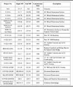
read: 1.3.2 History of the Project Route
http://azdot.gov/docs/default-sourc...rior-fdcr-chapter-i-introduction.pdf?sfvrsn=4

frpm that link
Table 1-1PREVIOUS ROADWAY PROJECTS
road history.png
 

Hal Croves

Silver Member
Sep 25, 2010
2,659
2,695
But the idea you can see numbers carved in stone in a rock formation on GE is a waste of time in my humble opinion. Or any other specific details.
They would have to be fairly large numbers for sure.
And even then light, weather, and camera angle would need to be just right.
 

markmar

Silver Member
Oct 17, 2012
4,117
6,259
Primary Interest:
All Treasure Hunting
But the idea you can see numbers carved in stone in a rock formation on GE is a waste of time in my humble opinion. Or any other specific details.

I believe some people see a GE image in every picture . Others just are happy and support theirs fault .

mm.jpg
 

Hal Croves

Silver Member
Sep 25, 2010
2,659
2,695
I found something interesting.

Wayne posted this article yesterday and I've seen it before. It contains a clue too the location of the Stone Map dig.

The McGee article in Frontier Times has had me puzzled for a while. I searched the area but the photo in the article didn't match the terrain. It matched the bridge but not the Terrain.

The back ground mountain range didn't match the road on the other side of the bridge. The road after the bridge goes right in the photo and the real road goes left. It never made any sense when I looked there the article photo didn't match and it had me wondering around where I found the holes Frank and Ryan found.

Well I think I may have just found the answer to it.

Take a look at this:

View attachment 1168199 View attachment 1168190 View attachment 1168191


It seems McGee mirrored the image Horizontally . Now since he went to all that trouble mirroring the image could the directions and locations be mirrored as well?

This may be a clue.

Burrow or Barrow pits are small construction pits used for the purpose of local fill issues while building or construction takes place. Frank and Ryan found the three barrow pits or dig pits associated with Travis's map of where he found them. Or did they?

Was McGee giving us a clue to mirror the instructions to the location where Travis found the maps?

I think I might know the true area where they were found and now it all makes perfect sense!

By the way, the photos are from GE and did solve this issue.

Nice work Bill. Actually, more than nice. Excellent.
Not to be a picky dicky because it is a GE image, only not a satellite image. Those images are taken on the ground using a vehicle.
Sorry to be a stickler for accuracy. You know I love GE.
 

UncleMatt

Bronze Member
Jul 14, 2012
2,389
2,530
Albuqerque, NM / Durango, CO
Detector(s) used
Garrett Infinium & Gold Bug II, Bazooka Super Prospector Sluice
Primary Interest:
All Treasure Hunting
That mirror effect was probably due to the printing processes being used at the time, and wasn't an attempt to give clues to anyone about anything at all.
 

Last edited:

Shortfinger

Hero Member
Apr 7, 2015
569
2,475
Valley Center, CA/Yuma, AZ
Primary Interest:
All Treasure Hunting
But the idea you can see numbers carved in stone in a rock formation on GE is a waste of time in my humble opinion. Or any other specific details.

Well, I have a few caveats there. Looking at ground view will not show anything like what is really there. However, if you are able to interpret overhead views, you may be able to see a rock formation that you can recognize from the ground. I have done this in reverse several times, with recognizable rock formations that I am familiar with, and was able to see them in GE. More rarely the other way around, but once or twice. However, I have to agree with you completely on the numbers, unless they were carved to be seen from above. And then they would have to be really big.
 

UncleMatt

Bronze Member
Jul 14, 2012
2,389
2,530
Albuqerque, NM / Durango, CO
Detector(s) used
Garrett Infinium & Gold Bug II, Bazooka Super Prospector Sluice
Primary Interest:
All Treasure Hunting
If you really want to convince people you have valid data to operate from, why not simply emulate Ryan here and get out in the field and collect the kind of data (photographic and otherwise) that will give your claims some weight? If you aren't in a position to do so for whatever reason, then simply accept that people will be skeptical.

Don't get me wrong, I use GE all the time and it is a valuable tool. It just can't show you as much as some people would like to think it can.
 

Last edited:

somehiker

Silver Member
May 1, 2007
4,365
6,426
Primary Interest:
All Treasure Hunting
Hi CW:

I realize you mean well, and are trying to help, but everything you have linked to re: the old/new US 60 applies only to the section of highway between Florence Junction and the mining town of Superior. That is the stretch which follows Queen Creek Canyon and many parts of the old/original road can still be seen down below the newer part.

Regards:SH.
 

Matthew Roberts

Bronze Member
Apr 27, 2013
1,131
4,955
Paradise Valley, Arizona
Primary Interest:
All Treasure Hunting
I found something interesting.

Wayne posted this article yesterday and I've seen it before. It contains a clue too the location of the Stone Map dig.

The McGee article in Frontier Times has had me puzzled for a while. I searched the area but the photo in the article didn't match the terrain. It matched the bridge but not the Terrain.

The back ground mountain range didn't match the road on the other side of the bridge. The road after the bridge goes right in the photo and the real road goes left. It never made any sense when I looked there the article photo didn't match and it had me wondering around where I found the holes Frank and Ryan found.

Well I think I may have just found the answer to it.

Take a look at this:

View attachment 1168199 View attachment 1168190 View attachment 1168191


It seems McGee mirrored the image Horizontally . Now since he went to all that trouble mirroring the image could the directions and locations be mirrored as well?

This may be a clue.

Burrow or Barrow pits are small construction pits used for the purpose of local fill issues while building or construction takes place. Frank and Ryan found the three barrow pits or dig pits associated with Travis's map of where he found them. Or did they?

Was McGee giving us a clue to mirror the instructions to the location where Travis found the maps?

I think I might know the true area where they were found and now it all makes perfect sense!

By the way, the photos are from GE and did solve this issue.

Bill,

Following this thread is like following a shotgun blast. However about every 20 posts or so something actually relevant does slip through the radar unnoticed.

The bridge in the newspaper article and photos is the old Silver King Road Bridge, built in 1916. Today it is called the El Camino Viejo Road Bridge. It spans Queen Creek about 2 and 1/4 miles to the North of the Route 60 Bridge over Queen Creek at Florence Station. This bridge was in the old days on the road from Mesa/Pinal to the Silver King Mine. There are two separate Bridges over Queen Creek in the area.

Each bridge has it's own special history with the Peralta Stone Maps but you have to go back to the beginning to understand both of those histories in their entirety.

Matthew
 

Shortfinger

Hero Member
Apr 7, 2015
569
2,475
Valley Center, CA/Yuma, AZ
Primary Interest:
All Treasure Hunting
Nice work Bill. Actually, more than nice. Excellent.
Not to be a picky dicky because it is a GE image, only not a satellite image. Those images are taken on the ground using a vehicle.
Sorry to be a stickler for accuracy. You know I love GE.

Bill, Agreed, excellent.

Hal, to be perfectly accurate, GE calls that image a "Street View" and it is, as you stated taken with a camera mounted to a vehicle. If you zoom in on GE to ground level (or a very low level) any place there is not a "Street View" available, you get what they call a "ground level view", which is a computer generated estimate of what you might see from that point. It may be close to what is there, or it may be completely hokey. Certainly not something you can use with any certainty.
 

UncleMatt

Bronze Member
Jul 14, 2012
2,389
2,530
Albuqerque, NM / Durango, CO
Detector(s) used
Garrett Infinium & Gold Bug II, Bazooka Super Prospector Sluice
Primary Interest:
All Treasure Hunting
I use street view screen shots all the time in my day job, and they serve me very well. That feature of GE allows me to avoid many days of travel around NM each week.
 

Las Vegas Bob

Sr. Member
Aug 25, 2005
351
267
Detector(s) used
Fisher Gold Bug
Primary Interest:
All Treasure Hunting
It's a fairly specific date but a little surfing on the interweb might give you an answer or leave you with your own opinion.
Personally, I don't think it's more than a play of light but I haven't been to that location to form any concrete opinion and I don't plan to.
Seems an easy enough task thou. Go there, take a few good photographs close up and then even closer of the tool marks. There would be tool marks.

Let us know what you find.

Hal old buddy, you wrote "Is that how the number thirty five would have been written in 1535?"

So you were not actually asking what style of numerical writing or font would have used in to write the number thirty five back in the year 1535? What then were you asking if not that.
 

Top Member Reactions

Users who are viewing this thread

Top