The Tumlinson Diary

starman 1

Full Member
Jun 3, 2010
157
305
Hello Everyone,

Since our friends in Texas have retreated to the bunker perhaps a discussion of the supposed Tumlison Diary would shed some light on the issues that have surfaced here, maybe not.

In Don Shade`s work published in 1994 he states the following on page 40: His comments are in reference to a discovery made by Ray Howland.

"In an old cabin, Ray found a saddle bag with a diary in it which had been kept by a man named Tumlinson from Texas. The diary told of a trip to Mexico to locate a mining family and gave a complete run down of the mines they had worked".

"The diary also told of an expedition composed of five hundred people, Tumlinson was one of them, who came from Mexico to Arizona in the 1890`s to look for treasure and an exceptionally rich mine. The Mexicans went home empty handed. Although this cannot be substantiated, Rose thought the Howlands prospected the Estrella Mountains for five years after finding the diary."

Interestingly enough Shade mentions the Stone Maps later in his work but makes no mention of Tumlinson in their discovery. Also it seems the diary is a complete document relating to mines the folks in Mexico had worked in The Superstitions(?).

So first can anyone add to this. Imagine the diary would be a wonderful read. Also does this suggest anything about the Stone Maps. Perhaps no one really knows the story regarding their discovery or creation. It seems at least possible if this expedition did happen where did the information come from in the diary to locate the mines?


Starman
 

Last edited:
OP
OP
S

starman 1

Full Member
Jun 3, 2010
157
305
Hello Everyone,

Perhaps it will be beneficial to add another link in a chain. Don Shade in his comments regarding the Stone Maps said on page 88:

"If you discard the writing on the stone tablets, you will end up with some astronomical symbols and depictions of certain physical phenomena that can be seen only at certain times on certain days of the year within the Superstition Mountains"

How is it that Don Shade was able to discern these things? Compare this to the reports that Travis Tumlinson knew nothing about the Stone Maps he found other than where they were found. Yet it has been said he used the small stone maps to create the maps that are today in the public view.

If the stone maps as Don Shade says has astronomical symbols does an understanding of these symbols suggest Travis could not have been the original creator? A starting point and only a starting point is an understanding of n-8-p.

Starman
 

somehiker

Silver Member
May 1, 2007
4,365
6,426
Primary Interest:
All Treasure Hunting
Hello Everyone,

Perhaps it will be beneficial to add another link in a chain. Don Shade in his comments regarding the Stone Maps said on page 88:

"If you discard the writing on the stone tablets, you will end up with some astronomical symbols and depictions of certain physical phenomena that can be seen only at certain times on certain days of the year within the Superstition Mountains"

How is it that Don Shade was able to discern these things? Compare this to the reports that Travis Tumlinson knew nothing about the Stone Maps he found other than where they were found. Yet it has been said he used the small stone maps to create the maps that are today in the public view.

If the stone maps as Don Shade says has astronomical symbols does an understanding of these symbols suggest Travis could not have been the original creator? A starting point and only a starting point is an understanding of n-8-p.

Starman


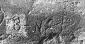
n-8-p ?
or 8-n-p
or 3-n-p
or 8-n2-p
or even 3-n2-p ????

3 N2 P.png

If you see n-8-p, you're probably wrong about this astronomical theory as well.

If taken as a "3", which appears on the Horse as well, there is a "P" just below in "PEDRO".
Below "PEDRO", a small hole.
If it's an "8", as found on the lower trail stone, a small hole below the curved "F" may correspond to the "P" in the inscription.
Are the two holes one and the same ?
And what about the tiny heart within the "P", which the second dash points to ?
Is there not another map, the "CURSUM (P)ERFICIO", where a short line points to a small heart as well ?
There's more, but I'll leave it at that for now.
 

Last edited:
OP
OP
S

starman 1

Full Member
Jun 3, 2010
157
305
Hello Somehiker

When Don Shade says:

"If you discard the writing on the stone tablets, you will end up with some astronomical symbols and depictions of certain physical phenomena that can be seen only at certain times on certain days of the year within the Superstition Mountains"

Do you have any thoughts on what he meant?

As I said N8P is only a starting point. We are both aware of the theories surrounding all of this. And perhaps you are right I am simply proposing a worn out theory and who knows where n8p is to be found. You might start with polaris and other things. But maybe the H/P stone is nothing more than a joke. A joke that has been played on well a number of folks. Perhaps the only meaningful symbols are the Horse that is close to a river and a M that is embedded on its main. Maybe, just Maybe this stands for Horse Mesa and in its deception laughling points to the true maps that also take you to Horse Mesa.

A true piece of humour that in its details take you to the eastern point in the range but in its essence reveals the truth that has always been right in front of you, in the western part of the range.

Just as an aside do you believe the Tumlinson Diary business? For me 500 Mexicans in the range in the 1890`s is pretty strange when you get to a detail level.


Starman
 

somehiker

Silver Member
May 1, 2007
4,365
6,426
Primary Interest:
All Treasure Hunting
Hello Somehiker

When Don Shade says:

"If you discard the writing on the stone tablets, you will end up with some astronomical symbols and depictions of certain physical phenomena that can be seen only at certain times on certain days of the year within the Superstition Mountains"

Do you have any thoughts on what he meant?

As I said N8P is only a starting point. We are both aware of the theories surrounding all of this. And perhaps you are right I am simply proposing a worn out theory and who knows where n8p is to be found. You might start with polaris and other things. But maybe the H/P stone is nothing more than a joke. A joke that has been played on well a number of folks. Perhaps the only meaningful symbols are the Horse that is close to a river and a M that is embedded on its main. Maybe, just Maybe this stands for Horse Mesa and in its deception laughling points to the true maps that also take you to Horse Mesa.

A true piece of humour that in its details take you to the eastern point in the range but in its essence reveals the truth that has always been right in front of you, in the western part of the range.

Just as an aside do you believe the Tumlinson Diary business? For me 500 Mexicans in the range in the 1890`s is pretty strange when you get to a detail level.


Starman

Are the symbols astronomical, or are they astrological ?
For that might give one an entirely different interpretation, would it not ?
That the recognition of an important location where items of great value were previously hidden would b made dependent on the seeker being on-site at specific times, and on specific days, seems risky at best. Earthly apparitions, usually geological in nature, are sometimes uncooperative as to their regularity of appearance, sometimes going dormant and frequently vanishing altogether for various reasons. Shadows and sun signs are weather dependent, leaving those who depend on them in the dark, should the "right day and time" happen to be overcast and gray. Star gazers are burdened by the same, coupled with the difficulty of following a path in tortuous terrain, even when the constellations are visible and the planets in the correct alignment. So I prefer to search without employing these aids, assuming that more learned men than myself would have known of these pitfalls.

You have apparently failed to note the great difference between the letter "M" on the Priest side of the stone, and the symbol within the horse's mane.
But you are not alone in making that assumption, and I would suggest a closer examination of that entire area of the stone and the details thereon. My own explorations in the field led to something entirely different than what was considered by others. It had nothing to do with Horse Mesa.

500 Mexicans roaming the Sups in the 1890's would have been quite the event, witnessed by the cattlemen, miners and prospectors of that day no doubt.
Even a group of 50 would have raised questions amongst the local population, do you not agree ?

Regards:SH.
 

Last edited:
OP
OP
S

starman 1

Full Member
Jun 3, 2010
157
305
The Way

Hello Somehiker,

Perhaps your response proves the craftsmanship involved in all of this. The details of the H/P Stone were intended to invoke exactly your response. That is the stone does not lead you to Horse Mesa. It actually leads you to just about anywhere else.

And let`s take this a bit further. For this to be effective a great deal of work would have to be done not only in creating the stone but also in creating the conditions in the range to prove the details to an astute observer such as yourself. Such an effort would require an excellent stone carver, and well a number of people.

The H/P stone simply put was intended to put you in a house of mirrors and spin you like a top. And that it has done. The creator of the stone also tells you in a rather humerous way who he is. Why of course our favorite wizard that some refer to as a priest. The Wizard of Oz.

As far as the details of the stone I will grant every observation you make regarding where it leads and what it is telling you. Not only that there are many, many details in the range that support most conclusions regarding the H/P stone. A lot of work went into that. But then again that is what a good wizard does. Also our wizard tells you that since the movie, "The Wizard of Oz", was made in 1939 this stones creation date was after 1939. Having said that the 1909 topographical Map was a stroke of genius.

On our Mexican friends I agree, 500 roaming the range would be quite the show. Can`t imagine that happening. But I guess stranger things have happened.

One final thing the signs are astronomical, although on one level the difference between the two is insignificant.

Regards,

Starman
 

Not Peralta

Bronze Member
Mar 23, 2013
2,167
3,061
Primary Interest:
All Treasure Hunting
Amigo's:coffee2 If using Orion, all one has to do is study the Orion zone,navigation is there,It tells the whole story,I have told you this before, It's very important to the south western cultures in many ways,the signs are located in many places.np:cat: PS.welcome back Starman.
 

Last edited:

Azquester

Bronze Member
Dec 15, 2006
1,736
2,596
Primary Interest:
All Treasure Hunting
Hello Everyone,

Perhaps it will be beneficial to add another link in a chain. Don Shade in his comments regarding the Stone Maps said on page 88:

"If you discard the writing on the stone tablets, you will end up with some astronomical symbols and depictions of certain physical phenomena that can be seen only at certain times on certain days of the year within the Superstition Mountains"

How is it that Don Shade was able to discern these things? Compare this to the reports that Travis Tumlinson knew nothing about the Stone Maps he found other than where they were found. Yet it has been said he used the small stone maps to create the maps that are today in the public view.

If the stone maps as Don Shade says has astronomical symbols does an understanding of these symbols suggest Travis could not have been the original creator? A starting point and only a starting point is an understanding of n-8-p.


Starman

Starman, You may be correct about astronomy.

On the top of these last stop Mining Skulls I discovered a large papal "P" made from a cross just below a drill hole for measuring I believe. Next to the Skull stone which is about the size of a Volkswagon is another stone with lichen made into a perfect "8". The four corners of this cross are lined up with true north or the northern star. But how can that be if the map was fabricated? Just coincidence as the keys I know are in another location so this is just another lost leader at the end site meant to throw you off if you get that far. So where ever that little tid bit of info come from on the HP stone? It has no true value even if that map was real which we now know it is not. So that being said I believe the stone map has deeper meaning far greater than one imagines. If like ORO said you start at Orion or like me at the northern star you'll end up full circle with your head looking up Uranus. Travis wanted it to be that way so everyone would be busy chasing their tails while he sipped whiskey at his camp.
 

Last edited:

Azquester

Bronze Member
Dec 15, 2006
1,736
2,596
Primary Interest:
All Treasure Hunting
n-8-p ?
or 8-n-p
or 3-n-p
or 8-n2-p
or even 3-n2-p ????

View attachment 1267997

If you see n-8-p, you're probably wrong about this astronomical theory as well.

If taken as a "3", which appears on the Horse as well, there is a "P" just below in "PEDRO".
Below "PEDRO", a small hole.
If it's an "8", as found on the lower trail stone, a small hole below the curved "F" may correspond to the "P" in the inscription.
Are the two holes one and the same ?
And what about the tiny heart within the "P", which the second dash points to ?
Is there not another map, the "CURSUM (P)ERFICIO", where a short line points to a small heart as well ?
There's more, but I'll leave it at that for now.

Bob Schoose made that Video in which is shows his version of where the Horse Map location was for. It's quite believable and has mountains ranges that mimic the names on the Map he shows of California I believe. Caballo, Pedro, Santa Fe, all in there. If the line points to a heart in the "P" that would be correct. The letter P has been the symbol of the cross representing the heart of Jesus for eons. The one I found is reversed. Which has another meaning. Death or Hell I suppose which goes with the grain in that line of thinking. In other words I found it on top of a mining skull boulder the symbol for death or death trapped entrances. Also the drill hole was just above the reverse "P" that to has another meaning. M=illi or a million. Sort of reminds of the Oak Island shows I watched last night and that tablet they found in code at the ninety foot level. What if any significance 9 or ninety feet have to with it is the mystery. But it does show they were using feet not rods or vara but feet. Does any of the so called maps make reference to what type of measurement units were used for the final distance? 18 places is too vague. That is exactly why I started looking for another source to give me a final measurement. That source turned out to be a matching skull with the numeral 75.

But still, 75 what?

If you think about it all the stone maps were meant to do is get you to the final location. The rest had to be in other maps not recovered if they are real hypothetically they should get you to the final mountain were the Kings fifth of Gold would be stored and you as the Treasure Hunter would need to know the rest of the puzzle to find the location of the coordinates for digging. That way they were never final maps the knowledge required for accessing those secret numerals are most certainly hidden by the Wizard near the final location of the entrance. Only a fool would give the whole map on a set of door stop tombstones.
 

Last edited:

sgtfda

Bronze Member
Feb 5, 2004
2,351
3,887
Mesa Arizona
Hello Everyone,

Since our friends in Texas have retreated to the bunker perhaps a discussion of the supposed Tumlison Diary would shed some light on the issues that have surfaced here, maybe not.

In Don Shade`s work published in 1994 he states the following on page 40: His comments are in reference to a discovery made by Ray Howland.

"In an old cabin, Ray found a saddle bag with a diary in it which had been kept by a man named Tumlinson from Texas. The diary told of a trip to Mexico to locate a mining family and gave a complete run down of the mines they had worked".

"The diary also told of an expedition composed of five hundred people, Tumlinson was one of them, who came from Mexico to Arizona in the 1890`s to look for treasure and an exceptionally rich mine. The Mexicans went home empty handed. Although this cannot be substantiated, Rose thought the Howlands prospected the Estrella Mountains for five years after finding the diary."

Interestingly enough Shade mentions the Stone Maps later in his work but makes no mention of Tumlinson in their discovery. Also it seems the diary is a complete document relating to mines the folks in Mexico had worked in The Superstitions(?).

So first can anyone add to this. Imagine the diary would be a wonderful read. Also does this suggest anything about the Stone Maps. Perhaps no one really knows the story regarding their discovery or creation. It seems at least possible if this expedition did happen where did the information come from in the diary to locate the mines?


Starman

Peg Leg and his children were illiterate
 

sgtfda

Bronze Member
Feb 5, 2004
2,351
3,887
Mesa Arizona
Hello Somehiker

When Don Shade says:

"If you discard the writing on the stone tablets, you will end up with some astronomical symbols and depictions of certain physical phenomena that can be seen only at certain times on certain days of the year within the Superstition Mountains"

Do you have any thoughts on what he meant?

As I said N8P is only a starting point. We are both aware of the theories surrounding all of this. And perhaps you are right I am simply proposing a worn out theory and who knows where n8p is to be found. You might start with polaris and other things. But maybe the H/P stone is nothing more than a joke. A joke that has been played on well a number of folks. Perhaps the only meaningful symbols are the Horse that is close to a river and a M that is embedded on its main. Maybe, just Maybe this stands for Horse Mesa and in its deception laughling points to the true maps that also take you to Horse Mesa.

A true piece of humour that in its details take you to the eastern point in the range but in its essence reveals the truth that has always been right in front of you, in the western part of the range.

Just as an aside do you believe the Tumlinson Diary business? For me 500 Mexicans in the range in the 1890`s is pretty strange when you get to a detail level.


Starman

The barn map could be a location map incorporating a star chart
 

sdcfia

Silver Member
Sep 28, 2014
3,654
8,869
Primary Interest:
Other
Bob Schoose made that Video in which is shows his version of where the Horse Map location was for.
<cut>

Yeah, that video caught my eye too. I don't know much about Schoose or where he got his information, but he speculated that the writing on the Horse Stone ("Santa Fe", "Cobollo (sic)", "Pedro", "Norte Del Rio (Rio del Norte?") placed its location in New Mexico, not Arizona. I watched the video many times trying to read his lips when the sound was beeped out as he mentioned the name of the prominent mine near his search zone. I think he said, "Santa Rita". Anyone else agree?

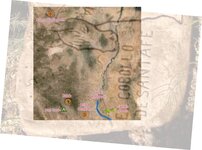
Anyway, I did some map work using the left-hand third of the stone and made some quite interesting discoveries. Since I'm not a believer in multiple "coincidences", I thought the discoveries were intriguing, if not significant, and support Schoose's contentions.

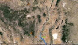
Below is a Google Earth view of southern New Mexico with certain symbols that I added and labeled that correspond to carved symbols on the Horse Map. The orange rings represent the circles with a center dot; the green pyramid is the omega sign; the blue curve (Rio Grande) is the carved curve next to the "COBOLLO"; the green cross is the carved cross near "COBOLLO". [[ If you like, I can email you a .kmz file so that you can verify the locations of my symbols with exact coordinates.]] Then I overlaid a part of the Horse Map, rotated and scaled it, and reduced its opacity so that you can see through it onto the GE image below it. As you can see, it's a perfect match - at least to the degree that the carved symbols are accurately placed, if that's what the carver intended.

horse map south.jpg

GE.jpg


Rio Grande (blue line) Self-evident.

Green Cross Nothing evident where the cross is situated on the Horse Map. The long arm of the cross points almost directly at Victorio Peak.

Caballo Reservoir There seems to be a divot or gouge at the right end of the Rio Grande line corresponding to the location of Caballo Reservoir. Beyond this point, the squiggle line appears to be a mountainous profile, not following the northerly-extended course of the river and apparently taking on some other purpose. The actual course of the Rio Grande seems to coincide with the overlaid horse's muzzle.

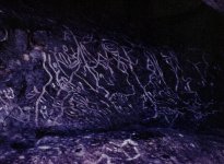
Map Cave (green pyramid Precisely at the carved omega ("last) symbol. Map Cave is a well-known and as yet unexplained petroglyph sit near Santa Rita del Cobre. Various explanations link it to Aztecs, Marcos de Niza, Spanish, rogue 16th century Europeans, the KGC and possibly others - all treasure related. Said to point to a rich mine and also a map to about forty caches of gold bullion in vicinity. Unverified reports that subterranean stone steps were uncovered by a treasure hunter nearby in the 1960s.

Map Cave 1.JPG

Bridal Chamber Precisely at circle-dot ("place" or "peak"). The Bridal Chamber was an unbelievably rich mass of near-pure silver ore discovered and mined near Lake Valley, NM. https://nmgs.nmt.edu/publications/guidebooks/downloads/37/37_p0293_p0296.pdf

Rabb Precisely at circle-dot ("place" or "peak"). A prominent barren peak on the east slope of the Black Range, at the head of Rabb Canyon, at a crossing of several old trails, and near the alleged discovery of a "mine with an iron door" in nearby Noonday Canyon by the brother of Gus Raney. Gus, legendary lawman, killer and self-appointed guardian of "church treasure" hidden in the El Malpais lava flow, killed a retired Treasury agent and his son in his back yard at age 101. A SOUTHWEST RANCH LEGEND DIES - NYTimes.com

raney2.jpg raney1.JPG
Fair use photos (getty and others)

Adams Diggings NM Precisely at circle-dot ("place" or "peak"). Abandoned Depression-era settlement (Post Office 1930-1946). Named for the famous Lost Adams Diggings, an event that allegedly occurred ca 1860s.

Conclusion If these coincidences relate to any sort of mapped reality, then it might be possible that the left hand portion of the Horse Map (symbol pattern and text) refers to certain landmarks in southwest New Mexico. If so, then the Horse Map was likely created no sooner than the 1920s or 30s (establishment of Adams Diggings NM, the Raney activities (if at all related), construction of Caballo reservoir. The horse figure itself, the five dots and other things (words, symbols, lines, etc) on the stone haven't been looked at by me, so I don't have an opinion on them. I wonder about the five dots. The "Rio" near them may also refer to the Rio Grande at the Caballos - only upside down. If rotated and placed on top of the GE photo, the five dots may represent five locations in the Caballos. More map-play is needed.
 

Weaversneedle

Full Member
Jan 22, 2016
126
95
Primary Interest:
All Treasure Hunting
Yeah, that video caught my eye too. I don't know much about Schoose or where he got his information, but he speculated that the writing on the Horse Stone ("Santa Fe", "Cobollo (sic)", "Pedro", "Norte Del Rio (Rio del Norte?") placed its location in New Mexico, not Arizona. I watched the video many times trying to read his lips when the sound was beeped out as he mentioned the name of the prominent mine near his search zone. I think he said, "Santa Rita". Anyone else agree?

Anyway, I did some map work using the left-hand third of the stone and made some quite interesting discoveries. Since I'm not a believer in multiple "coincidences", I thought the discoveries were intriguing, if not significant, and support Schoose's contentions.

Below is a Google Earth view of southern New Mexico with certain symbols that I added and labeled that correspond to carved symbols on the Horse Map. The orange rings represent the circles with a center dot; the green pyramid is the omega sign; the blue curve (Rio Grande) is the carved curve next to the "COBOLLO"; the green cross is the carved cross near "COBOLLO". [[ If you like, I can email you a .kmz file so that you can verify the locations of my symbols with exact coordinates.]] Then I overlaid a part of the Horse Map, rotated and scaled it, and reduced its opacity so that you can see through it onto the GE image below it. As you can see, it's a perfect match - at least to the degree that the carved symbols are accurately placed, if that's what the carver intended.

View attachment 1268130

View attachment 1268170


Rio Grande (blue line) Self-evident.

Green Cross Nothing evident where the cross is situated on the Horse Map. The long arm of the cross points almost directly at Victorio Peak.

Caballo Reservoir There seems to be a divot or gouge at the right end of the Rio Grande line corresponding to the location of Caballo Reservoir. Beyond this point, the squiggle line appears to be a mountainous profile, not following the northerly-extended course of the river and apparently taking on some other purpose. The actual course of the Rio Grande seems to coincide with the overlaid horse's muzzle.

Map Cave (green pyramid Precisely at the carved omega ("last) symbol. Map Cave is a well-known and as yet unexplained petroglyph sit near Santa Rita del Cobre. Various explanations link it to Aztecs, Marcos de Niza, Spanish, rogue 16th century Europeans, the KGC and possibly others - all treasure related. Said to point to a rich mine and also a map to about forty caches of gold bullion in vicinity. Unverified reports that subterranean stone steps were uncovered by a treasure hunter nearby in the 1960s.

View attachment 1268154

Bridal Chamber Precisely at circle-dot ("place" or "peak"). The Bridal Chamber was an unbelievably rich mass of near-pure silver ore discovered and mined near Lake Valley, NM. https://nmgs.nmt.edu/publications/guidebooks/downloads/37/37_p0293_p0296.pdf

Rabb Precisely at circle-dot ("place" or "peak"). A prominent barren peak on the east slope of the Black Range, at the head of Rabb Canyon, at a crossing of several old trails, and near the alleged discovery of a "mine with an iron door" in nearby Noonday Canyon by the brother of Gus Raney. Gus, legendary lawman, killer and self-appointed guardian of "church treasure" hidden in the El Malpais lava flow, killed a retired Treasury agent and his son in his back yard at age 101. A SOUTHWEST RANCH LEGEND DIES - NYTimes.com

View attachment 1268168 View attachment 1268169
Fair use photos (getty and others)

Adams Diggings NM Precisely at circle-dot ("place" or "peak"). Abandoned Depression-era settlement (Post Office 1930-1946). Named for the famous Lost Adams Diggings, an event that allegedly occurred ca 1860s.

Conclusion If these coincidences relate to any sort of mapped reality, then it might be possible that the left hand portion of the Horse Map (symbol pattern and text) refers to certain landmarks in southwest New Mexico. If so, then the Horse Map was likely created no sooner than the 1920s or 30s (establishment of Adams Diggings NM, the Raney activities (if at all related), construction of Caballo reservoir. The horse figure itself, the five dots and other things (words, symbols, lines, etc) on the stone haven't been looked at by me, so I don't have an opinion on them. I wonder about the five dots. The "Rio" near them may also refer to the Rio Grande at the Caballos - only upside down. If rotated and placed on top of the GE photo, the five dots may represent five locations in the Caballos. More map-play is needed.

Very interesting research but 300 years ago they didn't have Google earth, kmz files , GPS or an airplane to fly over an area they planned to map so I would not get too excited about Bob's theory . In my opinion they didn't rely on maps much except to get them in the correct region. From there they used ground markers carved into cactus or rock walls
 

Last edited:

sdcfia

Silver Member
Sep 28, 2014
3,654
8,869
Primary Interest:
Other
Very interesting research but 300 years ago they didn't have Google earth, kmz files , GPS or an airplane to fly over an area they planned to map so I would not get too excited about Bob's theory . In my opinion they didn't rely on maps much except to get them in the correct region. From there they used ground markers carved into cactus or rock walls

I agree with your idea that nearly all the "treasure maps" that we see - complete with complex imagery, symbols, codes, etc., are totally modern creations.

I suspect Schoose figured that this map had something to do with Spaniards, Jesuits, et al. Isn't all southwest treasure Spanish or Jesuit? Ha ha. I believe that Schoose had a logical mind and a good eye for detail, but was wrong about the source of information on the carving. I don't see any evidence that the Horse Map indicates an Arizona location, but plenty for New Mexico. In that respect, I think Schoose was correct.

I believe the Horse Map was created no sooner than the 1920s or 30s, or even later - the symbols indicate locations of some sites that did not exist until then. Even in the early 20th century, there were accurate surveying protocols, USGS topo maps and airplanes - more than enough to create an accurate map whose image could be transferred onto a slab of rock, then carved. Whether the Horse Map has any connection to the other Peralta Maps, I don't know. All this stuff begins with Pegleg, who, it is said, had lots of maps. What the purpose of the Horse Map is, I don't know. Maybe it leads to something valuable, or maybe it's some sort of clever deception.
 

Last edited:

Azquester

Bronze Member
Dec 15, 2006
1,736
2,596
Primary Interest:
All Treasure Hunting
Well, since I live in NM, I'd like to hear it.

I second that motion!

Before modern Maps the maps they used were feeble renditions of the actual landscape hardly capable of showing any aerial views as they had no satellites or airplanes for that matter. The only thing they had was an astrolabe, the Sun / Moon cycles and math. So the Peralta Stones at best are not showing anything from the air. They could climb mountain peaks and get a distorted angled view of the landscape hardly good enough for any overlays.

And the fact those ranges were called totally different names in the Spanish conquest times shows the maps are either newer renditions of modern maps or they are not of that or any other mapped area's in our time.

If one or two of the stones were to be confirmed as genuine historical carvings they would surely be encoded as Longitude / Latitude for ground retrieval at a later date. If they are real I suppose the symbolic nature may indicate a possible generic guide for many areas. In Free Masonry it would be used as a loosely open guide for locating many such area's and standardized symbolism in such cases. The fact remains the maps have no real guided purpose so this is highly likely. IF they are somehow proven to be carved historical guides. Sort of like Arizona Highways 1847 edition.

I believe the truth may lie with historical Spanish, not Mexican, Hacienda owners of mines and their maps if anyone had access to an authentic one that may shed some light on some of this.

So many add on's have occurred over the course of the last 100 years of the Superstition Legend it muddies the water to the degree that it may never become clear again.

So Bob took the stones away from the Muddy water and attempted to lay out a new case for New Mexico. Great Idea if they were real historical too modern map overlays.

I don't think it'll work but more power to the man for trying.
 

Azquester

Bronze Member
Dec 15, 2006
1,736
2,596
Primary Interest:
All Treasure Hunting
Very interesting research but 300 years ago they didn't have Google earth, kmz files , GPS or an airplane to fly over an area they planned to map so I would not get too excited about Bob's theory . In my opinion they didn't rely on maps much except to get them in the correct region. From there they used ground markers carved into cactus or rock walls

That fits right in with my theory. If they used rock walls and other plant markers they most certainly would need a way to get that close so large mountain side highway signs would be required for positioning the Mule Train into the right area's of mining or fresh water for that matter. One of the most common symbols for water is a fish. Very simple symbol to make. The most important commodity in traveling Hostile terrain would be water and knowing where the Hostiles lived. A simple Indian head pointing would do the trick. Again Longitude and Latitude would get them close no map required except for maybe main trails. Those were most likely marked at the time very well with stacks of rocks or dead Spanish / Indian bodies.


I know the Catalina Mountain Range has a horses head near the top of it visible all the time from the valley as it's made from a large cliff of rock. It doesn't really show anything just that the Horse was their only way of travel and that made it invaluable to the Conqueror's.
 

Top Member Reactions

Users who are viewing this thread

Top