You are using an out of date browser. It may not display this or other websites correctly.
You should upgrade or use an alternative browser.
You should upgrade or use an alternative browser.
New to the forum
- Thread starter Big Dan
- Start date
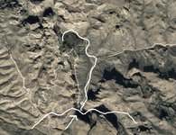
I am new to this forum, but really want some advice from someone who has had boots on the ground. The clues keep taking me to this spot.
View attachment 1395846
gee dan..do you think you could have found a spot that's a little tougher to get to?
Hey, nobody would think to look there. It might have been a little tougher in 1875.
i dont think you will be able to sucker anyone into going down there to have a look for you...go have a look for yourself and you'll see why
deducer
Bronze Member
- Jan 7, 2014
- 2,280
- 4,352
- Primary Interest:
- Other
I am new to this forum, but really want some advice from someone who has had boots on the ground. The clues keep taking me to this spot.
View attachment 1395846
Hi Dan,
That place you marked with an arrow is at the bottom of Fish Creek Hill- a harrowing hair-raising drive to get there, and a drop of 1500'. Here are some "boots on the ground" pictures- no treasure to be found there, but it is a popular stopping place for tourists who make it down. The cave at bottom right in the picture is rumored to have been one of Geronimo's hideouts.
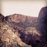
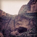
deducer
Bronze Member
- Jan 7, 2014
- 2,280
- 4,352
- Primary Interest:
- Other
Thanks for the info. The arrow and line following the creek are actually a tracing I made from the stones. My area of interest is at the end of that white line I drew on the map further up the creek.
By stones, did you mean the Stone Maps?
That would be the Horse Mesa side of Fish Creek Canyon. Be very careful if you do go hiking there- it's a pretty steep drop to the canyon bottom. Pretty inhospitable territory as Dave said. Best way to explore Fish Creek is to start at the Apache Trail road bridge and work the tiny trail on the south side. It's not an easy hike by any means.
deducer
Bronze Member
- Jan 7, 2014
- 2,280
- 4,352
- Primary Interest:
- Other
Yes, I was referring to the stone maps. That area seems to fit closely. Hiking that area is out of the question for me, as I live in Mississippi. Thanks.
No problem. And just so you know, using google maps to search for treasure has gotten plenty of people in trouble. It can be very deceptive- looks easy from above, but from the ground.. it's usually a completely different story, especially if you're trying to hike off-trail.
wrmickel1
Bronze Member
No problem. And just so you know, using google maps to search for treasure has gotten plenty of people in trouble. It can be very deceptive- looks easy from above, but from the ground.. it's usually a completely different story, especially if you're trying to hike off-trail.
Yes even the Great Ryan got whooped by GE[emoji41]
Wrmickel1
Agree with you guys on the problems using Google Earth perspectives.
But at this particular spot, you can use the GE 'Street View' (actual photos) for a good feel of that portion along Apache Trail.
Welcome to TN Big Dan.
But at this particular spot, you can use the GE 'Street View' (actual photos) for a good feel of that portion along Apache Trail.
Welcome to TN Big Dan.
somehiker
Silver Member
- May 1, 2007
- 4,365
- 6,426
- Primary Interest:
- All Treasure Hunting
Gotta wonder what kinda shape their fancy camera was in, after touring the entire gravel section of the Apache Trail though ?
In all these years, I've only driven it a couple of times when it wasn't mostly wash-board rough.
https://www.google.com/streetview/images/understand/device-car.jpg
http://cdn0.dailydot.com/uploaded/images/original/2012/10/24/Maps_car_crash.jpg
In all these years, I've only driven it a couple of times when it wasn't mostly wash-board rough.
https://www.google.com/streetview/images/understand/device-car.jpg
http://cdn0.dailydot.com/uploaded/images/original/2012/10/24/Maps_car_crash.jpg
Last edited:
captain1965
Full Member
When I was young, my family regularly camped at apache lake. My dad would drive our camper inches from the edge to scare us. As a child it was fairly traumatic seeing all the automobiles smashed up at the bace of those cliffs. Beautiful hike though.


Old
Hero Member
>>>>>>>>>Yes even the Great Ryan got whooped by GE
Wrmickel1 <<<<<<<<<<
Care to expand on this? I'm interested in that Ryan's modern tool kit doesn't run to Google Earth. He uses a different map set as his "go to" aid. I, on the other hand, do use GE as my go to reference. Just interested in what you are referring to.
Wrmickel1 <<<<<<<<<<
Care to expand on this? I'm interested in that Ryan's modern tool kit doesn't run to Google Earth. He uses a different map set as his "go to" aid. I, on the other hand, do use GE as my go to reference. Just interested in what you are referring to.
somehiker
Silver Member
- May 1, 2007
- 4,365
- 6,426
- Primary Interest:
- All Treasure Hunting
Linda:
Could be he's thinking of something different, but I'd bet mick is referring to RG's only real pre-drone hiking attempt.....aka the 2 1/2 mile one-way hike he did to the Bat Cave area.
You might be able to find his video on YouTube.
Could be he's thinking of something different, but I'd bet mick is referring to RG's only real pre-drone hiking attempt.....aka the 2 1/2 mile one-way hike he did to the Bat Cave area.
You might be able to find his video on YouTube.
Last edited:
sdcfia
Silver Member
- Sep 28, 2014
- 3,648
- 8,863
- Primary Interest:
- Other
No problem. And just so you know, using google maps to search for treasure has gotten plenty of people in trouble. It can be very deceptive- looks easy from above, but from the ground.. it's usually a completely different story, especially if you're trying to hike off-trail.
It's a good tool for finding trails, old two-tracks, wall outlines (ruins), possible disturbed ground and the like if the photos are high enough resolution. Choosing different photo dates helps verify results in some cases, although the older ones usually aren't as pixel rich. Except in a general sense, it's no better than quad sheets for determining the lay of the land. On the actual ground, all bets are off until you're standing on it.
somehiker
Silver Member
- May 1, 2007
- 4,365
- 6,426
- Primary Interest:
- All Treasure Hunting
Hey, nobody would think to look there. It might have been a little tougher in 1875.
Hi Dan:
Well, it would have been a little tougher to get to your starting point back in 1875, especially with a few hostiles hanging around out there, but it's easy to get to now.
Since 1905, folks have been able to get there by horse and wagon or car, and on many days hundreds will kick up dust clouds as they drive along the lower section of your SM trail.
Many others will park along side that section of the road, as they enjoy the cooler temps down at the bottom on hot days. I've added a few labels to your GE view, based on the practical observation and knowledge that many of us share. It's a pretty famous and heavily trod place. The creek at that point usually has flowing water in it, and two deep depressions (aka tanks) on the east side of the bridge and below the cave are frequently used as a swimming hole by visitors.
If you were to visit yourself, you would be able to leave your car at the parking area shown about half-way along your SM trail. From there, it's only about 1/2 mile or so down the creek to where you would have to begin the short climb up the wash to where your trail ends. From that point you would be able to wave to anyone watching you from the popular observation point up above.
I'm assuming the " Heart " I've marked, is the basis for your conclusion.....
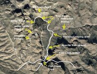
Regards:SH.
links to more....http://apachetrailarizona.com/apache-trail-history.html
https://books.google.ca/books?id=11...epage&q=fish creek lodge/apache trail&f=false .....old photos of the Apache Trail and Fish Creek Station/Lodge.
edit.....corrected location of Fish Creek Lodge
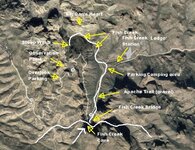
Last edited:
Old
Hero Member
Thanks Somehiker, It had been a long time since I first viewed Ryan's Journey to the Bat Cave. Man, that seems like forever ago.
Its good footage for anyone who wants a glance at the territory. Its beautiful but treacherous.
But; I fail to see where Ryan "got whooped by GE". I don't see where he got whooped at all. I know he uses a different map set as his "go to" but will often refer to GE for the general user (me included).
If anything his video re-enforces the general reader's need to use caution on any hike and particularly an off trail hike. Where's the problem? Other than to those who want to believe in the fake drama portrayed in some ( ) venues.
Its good footage for anyone who wants a glance at the territory. Its beautiful but treacherous.
But; I fail to see where Ryan "got whooped by GE". I don't see where he got whooped at all. I know he uses a different map set as his "go to" but will often refer to GE for the general user (me included).
If anything his video re-enforces the general reader's need to use caution on any hike and particularly an off trail hike. Where's the problem? Other than to those who want to believe in the fake drama portrayed in some (
 ) venues.
Top Member Reactions
-
 2604
2604 -
 1181
1181 -
 1076
1076 -
 889
889 -
 863
863 -
 839
839 -
 793
793 -
 677
677 -
 645
645 -
 610
610 -
 496
496 -
 476
476 -
 475
475 -
 473
473 -
 464
464 -
 430
430 -
O
405
-
 402
402 -
 386
386 -
 383
383
Users who are viewing this thread
Total: 2 (members: 0, guests: 2)
