The mysterious death of Adolph Ruth

OP
OP
Matthew Roberts

Matthew Roberts

Bronze Member
Apr 27, 2013
1,131
4,955
Paradise Valley, Arizona
Primary Interest:
All Treasure Hunting
One important thing that stood out while I was going through the various Sheriff's reports was the fact Adolph Ruth had more than one map with him when he came to Arizona.
The Perfil Map of course became the most widely known and talked about. But he had other maps with him, some that he had acquired from his son Erwin and at least one that he had gotten from Morse and other(s) that no one is certain how he may have acquired them. That is not unusual for a treasure hunter. Many times I have been in the Superstition Mountains and have carried several different maps myself.

What I came to believe is that Ruth was not just searching with one particular map but was in the mountains to search and try to locate as many as two or three separate locations and each map led to a different area. Morse, Purnell and Keenan seemed to be the vehicle that was going to get him to each of these locations.

I believe (my personal opinion) he choose to camp at Willow Spring because it had water in the heat of summer, was close to one of the sites he wanted to search and was not far for Purnell and Keenan to come and go with supplies and take him to the different areas he wanted to look at.

Matthew
 

markmar

Silver Member
Oct 17, 2012
4,117
6,259
Primary Interest:
All Treasure Hunting
Maybe Ruth was not sure for a specific region , and he wanted to see different views\angles of Weavers Needle and its surrounding landmarks .
If so , Peters Mesa proved to be too far from his camp and a fatal hike for a hot summer day .
 

OP
OP
Matthew Roberts

Matthew Roberts

Bronze Member
Apr 27, 2013
1,131
4,955
Paradise Valley, Arizona
Primary Interest:
All Treasure Hunting
Maybe Ruth was not sure for a specific region , and he wanted to see different views\angles of Weavers Needle and its surrounding landmarks .
If so , Peters Mesa proved to be too far from his camp and a fatal hike for a hot summer day .

markmar,

I agree (my opinion) that Adolph Ruth was interested in seeing Weavers Needle from more than just one angle or view.
Peters Mesa provides one of the most dramatic views of Weavers Needle and is an exact match for the way it appears on at least one very well known map.

No one can seriously hike the Superstitions in June-July-August. It is just too hot. When I was younger I could go in the Superstitions in those months but could move about only very early in the mornings and as the Sun was setting in the evening. Once the Sun was overhead you had to find shade and just rest up. If you could time your trip in the mountains with the full moon you could travel around, as when the full moon was directly overhead at midnight you could walk around as if it were daylight. Ruth however went into the Superstition Mountains during the dark of the moon.

I don't believe Ruth under his own power could possibly have hiked from Willow Spring to Peters Mesa or even to where he was eventually found at the NW end of Black Top Mesa.
He had to have help to have gotten to either one of those places, and by help I mean someone with horses.

Matthew
 

Last edited:

azdave35

Silver Member
Dec 19, 2008
3,606
8,104
deducer

Thank you for your input . I was not aware of what maps had Ruth with him in his last days . The only I knew he had , were the Perfil map and the Bicknell's route and clues from a journal .
What I wrote about Ruth death in this thread , was only my opinion based in my logic . I had not intend to contradict or doubt what anybody write here .
Now about maps , from what I know about . The maps are worthless if you don't know for what region were made . The treasure maps were not made to show the real relief or a region as is in the field , and are very complicated and difficult to recognize .
Is very difficult to recognize the scale which had used the map maker or what symbols had used for specific landmarks . Sometimes even you believe how you have recognized the region in the map , the map maker could use for orientation things that you never would believe he could use . Only the map maker knows the region on the map and to guide someone else there , have to give few instructions as are some clues and a route .

marius....i'm with you about maps...they are pretty much only good to the person that made them....when people make maps they change things around so only they can read them
 

Azquester

Bronze Member
Dec 15, 2006
1,736
2,596
Primary Interest:
All Treasure Hunting
Maybe Ruth was not sure for a specific region , and he wanted to see different views\angles of Weavers Needle and its surrounding landmarks .
If so , Peters Mesa proved to be too far from his camp and a fatal hike for a hot summer day .

I tried hiking in a heat wave in there once...from first water...I did it with a heavy pack full of mainly, water.
After about a mile in 120 degree heat I turned around. By the time I made it back to my truck I had consumed a third of the water. I took five gallons. In daytime heat in those mountains with a large amount of water you could only go over rough terrain about half of that distance. So unless Ruth traveled by night, left early before sunrise, he only made it a few thousand feet in the heat. That is unless he was taken by horse back. I suppose he may have left early that would give him maybe a mile or two more. Impossible to get back in the daytime unless he had many gallons of water on him. Maps don't provide moisture. You don't make it that far with out water in the summer during the day.

Nice debate!
 

releventchair

Gold Member
May 9, 2012
22,393
70,704
Primary Interest:
Other
Ruth was vulnerable it seems on his last trip. He would not be going far, or fast if anyone wanted to watch or molest him.
What was on him ,or in his hand when or before he died we really don't know.....
If it was gold then interrogation could follow if he was not seen acquiring it. To heck with his maps ( unless one was missing). Though maps can be copied then altered and put back. Had he been robbed of info ,letting him go and allow authorities to get wind of it may not have seemed a good idea.

Too many people knew where he could be found and what he was doing after being dropped off.. Heck , he was Ruth and well known for seeking knowledge of certain subjects.

A body found by choice of the some one causing it's untimely death would be found distant from point( s) of interest. That can be agreed on.

He could have intruded on the wrong party by random chance. No stranger to the game he seemed to be knowledgeable enough to steer clear of imposing on a remote diggin though ,or ask too many personal questions if crossing trails when outback ,or clearing out after a warning shot. ?????

If some one wanted him at their mercy on his last outing ..they had him. No one ,or even a dog on guard/ watch when he closed his eyes to rest.
 

Last edited:

H-2 CHARLIE

Bronze Member
Dec 1, 2012
1,204
507
on the rocks - so cal county line
Detector(s) used
Gold bug pro / Minelab GM 1000
Primary Interest:
All Treasure Hunting
Bottom line is Ruth had maps but never had any rich gold ore .
So he was the closest one to locating the fabled mine .
Great story guys thanks for kicking it around .
 

azdave35

Silver Member
Dec 19, 2008
3,606
8,104
Bottom line is Ruth had maps but never had any rich gold ore .
So he was the closest one to locating the fabled mine .
Great story guys thanks for kicking it around .

if he did have any gold on him i'm sure whoever smoked him liberated it from his body
 

deducer

Bronze Member
Jan 7, 2014
2,281
4,360
Primary Interest:
Other
deducer,

Thank you for your reply and question.

Towards the bottom of page 8, Ely writes this:

"In the thick brush overlooking West Boulder Canyon, about one hundred feet above the canyon floor, one of the dogs came upon a skull-to which particles of flesh still adhered."

We have been assured that a number of important (to the family) details were changed or left out of Ely's book. The details of the above statement may be something that slipped by unnoticed. The fact that it describes an area that Ruth could have reached on foot, the fact that the view of Weaver's Needle that I have posted, and the fact that a claim exists in the saddle at that point, do give some credence to the theory. Ruth was not unfamiliar with the Superstitions. He chose to camp at Willow Spring, despite the fact that water was available closer to where his skull was said to be found. The instructions found on Ruth could easily lead one into Willow Spring.

If you want to quote Gene Reynolds, we were friends. I talked him into putting out his book on CD, numbering and signing them. I have #1. It was Gene who asked me for a picture of Weavers Needle taken from the saddle that separates Little Boulder and West Boulder Canyons. He is the person who confirmed that it was the view Ruth was looking for. Gene was the first person, as far as I know, to seek and find Stella (Ruth) Hawkins. Much of his information came from that first, direct, contact.

As for Matthew, I had a personal relationship with him that went on for a number of years. I believe I know him as well as anyone else and better than many. I also know his true history. Others can accept his stories at face value and feel comfortable with that. I will need to see better sources than I might need from others. That's not saying that the story he has posted here is not true. I believe it might very well be, and truly hope it is.

As for your final question, I personally believe that is where Ruth's body was actually found. There is a running spring below the west side of the saddle, in a north/south running ravine.

Good post and good questions.

Good luck,

Joe Ribaudo

I do understand where you are coming from when you ask for sources. I'd pretty much be the same, but what I've come to realize is that this isn't a scholar website or field, and this field that we are dealing with is by it's very nature always going to be full of deception, misleading or withheld information. I think it's up to each of us to develop the ability to separate the wheat from the chaff, in our own ways, and using our methods.

Matthew may not be able to reveal his sources- you have a number of sources you can't reveal because you have been asked not to, and I have plenty of my own- there is much information I can't release because I have been asked to keep them confidential.

So I imagine it's tricky and probably very frustrating at times, but that's the nature of TH. But I think that when you acquire enough information, you start to detect patterns and see corroborations from separate sources, and that's where you can develop a feel or an instinct for what happened and where.

And my sense is that Barkley/Adams were not straightforward about what really happened and that they participated in some sort of coverup.

For example, Adams writes about finding the body and in no more than two days was off looking for what the maps led to. What ethical sheriff would do this? Why wasn't he busy investigating who/where the murderer was?

Unless he already knew who did it?

I wonder what Frank thinks of this, considering his background. You out there Frank? What is your take on this?
 

deducer

Bronze Member
Jan 7, 2014
2,281
4,360
Primary Interest:
Other
One important thing that stood out while I was going through the various Sheriff's reports was the fact Adolph Ruth had more than one map with him when he came to Arizona.
The Perfil Map of course became the most widely known and talked about. But he had other maps with him, some that he had acquired from his son Erwin and at least one that he had gotten from Morse and other(s) that no one is certain how he may have acquired them. That is not unusual for a treasure hunter. Many times I have been in the Superstition Mountains and have carried several different maps myself.

What I came to believe is that Ruth was not just searching with one particular map but was in the mountains to search and try to locate as many as two or three separate locations and each map led to a different area. Morse, Purnell and Keenan seemed to be the vehicle that was going to get him to each of these locations.

I believe (my personal opinion) he choose to camp at Willow Spring because it had water in the heat of summer, was close to one of the sites he wanted to search and was not far for Purnell and Keenan to come and go with supplies and take him to the different areas he wanted to look at.

Matthew

Gene Reynolds also wrote:

The fact is, the 1931 trip, which was [Ruth's] last, was certainly not his first trip into the Superstitions. I have in my possession, information (copied from Ruth's own notes) that describes an earlier trip he made into the superstitions in which he spent 3 days headquartered at the Tortilla Ranch. His first day he spent exploring the area we know today as the Miller Mines area but George Miller and Robert Aiton were already established there and he presumed that if there had been anything of value to be found there, they had already found it. His second day was spent exploring the "Indian Spring Canyon" area and the third day he followed what we know today as Peter's Trail around the Eastern corner of Tortilla Mountain to a saddle that offered him a spectacular view overlooking Weaver’s Needle & Peter's Mesa. I do not have any documentation for it, but I was told that he also made at least one other exploratory trip into the Superstitions by way of the old Milk Ranch.

Ruth was very well prepared for the 1931 trip. He had studied the mountains from several different entry points and knew exactly what he would need in the way of supplies for the length of time he intended to stay. He planned to make his camp near a source of water and had a thermos for carrying water on trail as he ventured out from his camp.
 

Real of Tayopa

Bronze Member
Sep 4, 2016
1,942
9,101
Mexico
Primary Interest:
All Treasure Hunting
start of the third day without water, stupid boo boo on our part. My partner hamming it up. Yes, I have posted this before. I want to emphasize, that if we hadn't found this water it was two days more without water, so I am here to bug you Bill,, thanks to this running arroyo.

.Third.jpg
 

OP
OP
Matthew Roberts

Matthew Roberts

Bronze Member
Apr 27, 2013
1,131
4,955
Paradise Valley, Arizona
Primary Interest:
All Treasure Hunting
Gene Reynolds also wrote:


deducer,

Gene Reynolds quote about Adolph Ruth having made previous trips to the Superstitions and in particular Ruth's interest with the view of Weavers Needle from that high saddle at the south end of Tortilla Mountain (which also is the southeast end of Peters Mesa), is very important in relation to what Tex Barkley told Walter Gassler.

If Ruth went a little further (and nothing says he didn't) he would have seen the exact view of Weavers Needle as depicted in one of the maps he was carrying.

I believe (my personal opinion) that Adolph Ruth was interested in a mine he believed to be near his Willow Spring camp, but also was interested in a map and a mine on Peters Mesa. That would be the mine shown on the map Tex Barkley found on Ruth's body and Tex, Jeff Adams and a few of their friends followed to a cave that was shown on that map.

Walter Gassler showed me the place on Peters Mesa where Tex Barkley had told him he found Ruth's body. Standing on that spot if you looked to the southeast you see that exact view of Weavers Needle as drawn on one of Ruth's maps.

Matthew
 

markmar

Silver Member
Oct 17, 2012
4,117
6,259
Primary Interest:
All Treasure Hunting
deducer

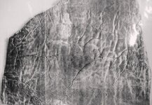
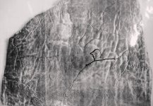
I have given a better look to the leather map that you posted . Is another Perfil map , maybe the original one .
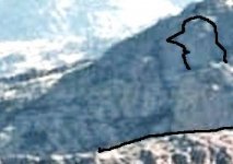
I would liked to see Brownie Holmes face when he saw for the first time the Perfil map with its " the rock that looks like a man over the point of a ridge " clue . I believe in that moment , this map just had validaded the route which had given Waltz to Brownie's father .
The question which arise is : Was Brownie Holmes aware about the Perfil map that Ruth possessed , before Ruth's death ( and maybe Brownie was in his shadow ) or after Ruth's death ?
And another question : Was aware Ruth of the directions that had given Waltz to Dick Holmes ?
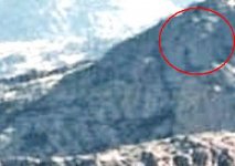
And now maybe you are wondering if that " rock that looks like a man over a ridge " exist . Of course exist . Let's see if the author of the Perfil map made a good copy . In my picture the ridge is lower because a highest altitude view .

leatherPmap.jpg leatherPmap 2.JPG

head.jpg head 2.JPG

I believe he was pretty good .
 

Last edited:

nobodie

Hero Member
Jul 17, 2015
596
887
Phx. A.Z.
Primary Interest:
All Treasure Hunting
On the leather map I see the horses head, a pointed ear and the other bent over. I guess that it's canyons but looks like the horses head on the stone map.
 

Cubfan64

Silver Member
Feb 13, 2006
2,986
2,789
New Hampshire - USA
Detector(s) used
Fisher CZ21, Teknetics T2 & Minelab Sovereign GT
Primary Interest:
All Treasure Hunting
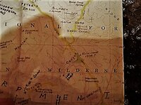
Always found this interesting - from the printed map on the back inside cover of "Superstition Mountain - in the Footsteps of the Dutchman" by Kollenborn and Swanson.

There is rumored to be evidence possibly in the form of a letter or letters to prove Adolph Ruth had been in the Superstitions prior to his summer trip of 1931 when he died, however I have yet to see it's existence. Interesting location for a possible Ruth camp in 1928 though isn't it?


IMG_2715 (002).jpg
 

deducer

Bronze Member
Jan 7, 2014
2,281
4,360
Primary Interest:
Other
deducer

I have given a better look to the leather map that you posted . Is another Perfil map , maybe the original one .
I would liked to see Brownie Holmes face when he saw for the first time the Perfil map with its " the rock that looks like a man over the point of a ridge " clue . I believe in that moment , this map just had validaded the route which had given Waltz to Brownie's father .
The question which arise is : Was Brownie Holmes aware about the Perfil map that Ruth possessed , before Ruth's death ( and maybe Brownie was in his shadow ) or after Ruth's death ?
And another question : Was aware Ruth of the directions that had given Waltz to Dick Holmes ?
And now maybe you are wondering if that " rock that looks like a man over a ridge " exist . Of course exist . Let's see if the author made a good copy . In my picture the ridge is lower because a highest altitude view .

View attachment 1457129 View attachment 1457130

View attachment 1457131 View attachment 1457133

I believe he was pretty good .

Hi Marius,

As you know, perfil is Spanish for profile, so it is the same thing I referred to when I called it the profile map.

Be careful of trying to associate it with the Superstitions, there is no evidence that it refers to the Superstitions. It may well concern California, rather. Even Edwin Ruth, himself wasn't certain and may have made a mistake in that regard.

I believe that what Ruth was looking for wasn't necessarily the LDM, but one of the mines dug out by the Spanish, probably by the Peraltas. There were scores of them.
 

Cubfan64

Silver Member
Feb 13, 2006
2,986
2,789
New Hampshire - USA
Detector(s) used
Fisher CZ21, Teknetics T2 & Minelab Sovereign GT
Primary Interest:
All Treasure Hunting
paul...did that map come in your book?....i have the same book but no map

Dave - it isn't an actual separate fold out map - it's just part of the printing on the back inside cover of the book. I believe Helen Corbin's first book also has the topo map inscribed on the inside covers, but I don't have it in front of me right now to check.

It was always my understanding that the map I posted was a portion of Tom Kollenborn's "master map" that he's added to over time.
 

markmar

Silver Member
Oct 17, 2012
4,117
6,259
Primary Interest:
All Treasure Hunting
Hi Marius,

As you know, perfil is Spanish for profile, so it is the same thing I referred to when I called it the profile map.

Be careful of trying to associate it with the Superstitions, there is no evidence that it refers to the Superstitions. It may well concern California, rather. Even Edwin Ruth, himself wasn't certain and may have made a mistake in that regard.

I believe that what Ruth was looking for wasn't necessarily the LDM, but one of the mines dug out by the Spanish, probably by the Peraltas. There were scores of them.

deducer

Three things make me think to associate the " rock that looks like a man over the point of a ridge " with the Superstitions Mountains .
The first is because Ruth had the "profile " map with him in the Superstitions . I believe he would not carried all the maps he had everywhere he would go . Also the " El sombrero " from the Perfil mapa was the Mexican name for the Weavers Needle .
The second is because the " man " clue from the map , is a perfect match with the clue that had given Waltz to Dick Holmes . IMO is the same clue .
And the third is because the " man rock " is in the Superstitions .
 

Last edited:

Top Member Reactions

Users who are viewing this thread

Top