Isogonic drift - March to May of 1767

OP
OP
El Gato

El Gato

Greenie
Aug 12, 2007
18
0
Arizona
Peerless

Not fight intended on my end.

I just don't see why CJ shouldn't be held to the same standards that he holds everyone else to. He says he knows how the maps work. His verbal explanation makes no sense when I put it on a topo.

I just want him to show me how it works when he puts it on a topo.

I see he has added the word "variances" to his explanation. I expect many of them and quite LARGE ones to make his trail fit on a topo.

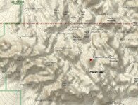
I gave him my explanation of how the trail works like he asked. (I even drew it on a topo for him so there would be no misunderstanding) Do you think it is unfair for me to now ask for the same thing in return?

El Gato
 

cactusjumper

Gold Member
Dec 10, 2005
7,754
5,388
Arizona
EG,

Not many people can hang with "ISOGONIC DRIFT", so the conversation may tend to drift, pardon the pun, now and again. :)

But the real answer to your questions lies in the folks, like you, who just can't get enough of the Stone Map subject. You don't want to talk about it, or believe anything I might say about it, but you just can't help digging for more information.

I don't mind giving you some answers as, at heart :), I'm a loving, sharing kind of guy.

None of the places where the trail goes is "impassable". Going over Hieroglyphic Canyon is something that any healthy hiker can manage. Admittedly you...as well as some who may be infirm, may find it "impassable".

Going over the ridge between East and West Boulder Canyon can be done with only moderate effort. I personally know people who have ridden their horses over that ridge.
Tracy Hawkins is one of those people. Considering some of the places Tom Kollenborn has ridden, I would not doubt that he has done the same.

You attempted to show me what was wrong with my "4 Peaks theory" and ended up looking foolish. As for my starting point.....you made no valid argument against it.

"Maybe I just don't understand your explanation, but the the burdon of proof is not on me to explain YOUR theory."

Don't believe anyone asked you to. By the same token, the "burdon" is not mine to make you understand my theory. Some tasks are just not in the realm of possibilities.
This seem like it might be one of them. Others, who took the time to do as I suggested, had no problem seeing the obvious trail depicted by the Stone Maps.

I assume you will be at the Rendezvous again this year. Had you come into my camp ....that's where all the people were gathered at last years event, you could have looked at my map, as I had one laying on the table for anyone who cared to examine it.
I expect I will do the same this year.

"It is your turn to bring out the photos of your monuments and mines and show us where you think the trail goes and how it all fits together with your triangles and hearts and monuments and mines and caves with gold bars. Oh... and yes, your slight variations too."

After blessing us with your theory of where the Stone Map Trail begins.....without the benefit of showing how the rest of the two trail maps flow from that starting point, you believe that entitles you to all of the above?

I hope I have answered some of your questions, but you will need to follow me, like a bad puppy nipping at my heels :)...... into another topic to gain any more snacks, as I will take your hint to leave "ISOGONIC DRIFT".

Take care,

Joe Ribaudo
 

Old Dog

Gold Member
May 22, 2007
5,860
397
Western Colorado
Cactus jumper said,...

Thom,

My aunt was not lying.

Joe

I understood that Joe,
AM. Lied either to your Aunt ,
Or lied when he denied talking to her.

That kind of thing will destroy any trust you guys had in Al.

Kind of amazing what greed will take the place of.

Thom
 

OP
OP
El Gato

El Gato

Greenie
Aug 12, 2007
18
0
Arizona
CJ

I didn't really expect an aswer to my question.
It was a fair question in consideration of the standards you hold everyone else to.

I guess that means you will no longer be demanding positive proof for anything anyone else says?

El Gato

P.S. Here is a blank map to draw your trail on if you can ever figure where it fits (Perfectly turn for turn to a "T") Oh I forgot... You changed that to "With slight variations".
 

Attachments

  • Joe trail.jpg
    Joe trail.jpg
    73 KB · Views: 436
OP
OP
El Gato

El Gato

Greenie
Aug 12, 2007
18
0
Arizona
cactusjumper said:
EG,

I hope I have answered some of your questions, but you will need to follow me, like a bad puppy nipping at my heels :)...... into another topic to gain any more snacks, as I will take your hint to leave "ISOGONIC DRIFT".
Take care,

Joe Ribaudo

CJ

Sorry I missed that last part.
You gonna take your alter ego (Old Dog) with you?
 

Old Dog

Gold Member
May 22, 2007
5,860
397
Western Colorado
I think you need to be a little objective here. If you think Joe needs an alter ego. you are on the wrong forum.
If you think the alter ego is myself... Let me explain something.
The drift you concern yourself so much with is inconsequential whe n it comes to the way this trail is laid out.
I am going to do exactly as the author of the discovery did.

I will leave you to do exactly as I didlay the maps out for your self.
see how they fit.
Leave a bit of room for elemental change.
(check the topos from the generational buildups.)
35, 45, 55, 65, 75... etc see the changes?
If you don't

you aren't doing the check and I am done with you

Good nite
good luck
 

the blindbowman

Bronze Member
Nov 21, 2006
1,379
30
El Gato said:
CJ

I didn't really expect an aswer to my question.
It was a fair question in consideration of the standards you hold everyone else to.

I guess that means you will no longer be demanding positive proof for anything anyone else says?

El Gato

P.S. Here is a blank map to draw your trail on if you can ever figure where it fits (Perfectly turn for turn to a "T") Oh I forgot... You changed that to "With slight variations".
ya i can draw it on there , i am sorry you were not talking to me, i didnt see that CJ thing up ther damn you were that close ! lol


yes , i do know where that fits and why....
 

Leones Corazon

Full Member
Mar 26, 2006
169
46
Grand Junction Colorado
Detector(s) used
Whites TM 808
Equinox 800
Go Find 60
Primary Interest:
Other
I guess i should google the term isogonic drift before i make a comment...but...

Working in the oil and gas industry drilling directional wells all over the place
magnetics play a key part in ensuring the accuracy of the well bore. What we
call magnetic declination is all important as i am required to take the numbers
from my well plot prior to spudding up and run them against our MIRP program
to ensure the accuracy of the numbers due to the constant fluctuation of the
magnetic field...as the earth spins on its axis the molten core jiggles like a cup
of coffee in your truck on the way to work in the am...thus the magnetic flux lines
are constantly moving. That being said....a compass bearing in use 300 years back
will be different today if declination is not accounted for. So if the bearing is used
to navigate to a distant target....ie: 1 - 5 - 10 miles.....the farther you get from where
the reading was taken the farther off you will be.

And....compinsating for declination is based off of a inturpulation of known data...so more
or less a best case guess.....

Joe...as it has been some time since we last spoke pm me on how the bradshaw trip went.
If you wish to see heart stones etc....i'll be happy to share a few pics with you personally
if you'd like to see what they look like in the field....and i believe my new friend and damn
near nieghbor - Old Dog - can attest to having seen the pics personaly...i do believe a few of
them made his eyes look like silver dollars....lol.

DW
 

Oroblanco

Gold Member
Jan 21, 2005
7,837
9,826
DAKOTA TERRITORY
Detector(s) used
Tesoro Lobo Supertraq, (95%) Garrett Scorpion (5%)
Just an observation, but if that period March to May of 1767 is to work, it has to be prior to the expulsion order. The expulsion order took place in June. It would also mean that the makers of the map would have been alerted prior to June, hence the need to make the maps.

Oroblanco
 

Springfield

Silver Member
Apr 19, 2003
2,850
1,383
New Mexico
Detector(s) used
BS
Does anyone really believe that if these stones were Jesuit creations pointing to a fabulous location of value in the Superstition Mountains, or anywhere else for that matter, that the brothers would allow any chance of them escaping their control? If so, I guess you don't know much about the SJ. Use your brains.
 

OP
OP
El Gato

El Gato

Greenie
Aug 12, 2007
18
0
Arizona
Springfield

According to what I have been reading, the SJ went through a bad period around 1751 during an Indian uprising against them. They had barely recovered from this when the expulsion took place. I think it is possible that they lost control of things during that period.

El Gato
 

Oroblanco

Gold Member
Jan 21, 2005
7,837
9,826
DAKOTA TERRITORY
Detector(s) used
Tesoro Lobo Supertraq, (95%) Garrett Scorpion (5%)
Well to be honest, I don't think the stone maps are Jesuit creations, I suspect they are modern hoaxes. I was just surprised that the time line for the magnetic drift would fit, IF the stone maps have magnetic north encoded on them, which I fail to see.

Oroblanco
 

cactusjumper

Gold Member
Dec 10, 2005
7,754
5,388
Arizona
While I know what "isogonic" means, and I know what "drift" is, I have no idea what "Isogonic drift" is. I hate to ask :-\, but who can explain the term: "Isogonic drift"?
Is it ever used with the two words joined in that manner?

Thanks,

Joe
 

Oroblanco

Gold Member
Jan 21, 2005
7,837
9,826
DAKOTA TERRITORY
Detector(s) used
Tesoro Lobo Supertraq, (95%) Garrett Scorpion (5%)
HOLA mi amigo CJ!

That is a fairly rare term - the Isogonic lines are the lines showing the magnetic declination for a compass at the various points on a map/chart, Isogonic drift is the movement of the magnetic North, which drifts a little all the time and requires corrections to maps and charts. Not sure if this is online or not, but there was a neat ancient map collection (U.of Tex?) that had a good explanation of the phenomenon and the various corrections seen on old maps over the centuries.

Oroblanco
 

cactusjumper

Gold Member
Dec 10, 2005
7,754
5,388
Arizona
Roy,

Thanks for your reply.

As I said, I know what both terms mean and how the are used.......but not how they can be used in this manner: "Isogonic drift". At an amateur guess, it seems like an amateur made up the joining of the two words to create.......confusion. Worked on me for sure. ???

Thanks again,

Joe
 

Oroblanco

Gold Member
Jan 21, 2005
7,837
9,826
DAKOTA TERRITORY
Detector(s) used
Tesoro Lobo Supertraq, (95%) Garrett Scorpion (5%)
Check out Amherst college site on the "Practical Navigator" - I think I have seen that term used on their site. However maybe it was "Isogonic line drift"? A side question here - do you own Gavin Menzie's 1421? I read his book a few months ago and don't remember if he addressed that little technicality. Thank you in advance,

Oroblanco
 

cactusjumper

Gold Member
Dec 10, 2005
7,754
5,388
Arizona
Roy,

I believe you are on the mark with "isogonic line drift" which, I believe, would refer to a magnetic declination chart.

Of course I have 1421.....doesn't everyone??? ;) He mentions that the Chinese had the compass "by the seventh century". They used that, in conjunction with the timing of the watches as well as Polaris to navigate the oceans. Maybe not the most accurate, but they got around.

I don't believe Menzies makes mention of any of the terms in question. He served on submarines for the Royal Navy, so perhaps bowman met him while he was a Submarine Captain. :) I assume he is very familiar with those terms.

"Isogonic Drift" is not in the "Practical Navigator".

Joe
 

gollum

Gold Member
Jan 2, 2006
6,729
7,594
Arizona Vagrant
Detector(s) used
Minelab SD2200D (Modded)/ Whites GMT 24k / Fisher FX-3 / Fisher Gold Bug II / Fisher Gemini / Schiebel MIMID / Falcon MD-20
Primary Interest:
All Treasure Hunting
Whether the Stone Maps were made by Jesuits, the Peraltas, or modern hoaxers, I personally think they were made by a very simple method:

1. Climb to the top of a high peak

2. Draw everything you see on paper

3. Climb back down

4. Transfer your paper drawing to stone

TahDaaaaah!

No need to worry about anything but basic North-South-East-West (Dagger)

Best-Mike
 

Springfield

Silver Member
Apr 19, 2003
2,850
1,383
New Mexico
Detector(s) used
BS
gollum said:
Whether the Stone Maps were made by Jesuits, the Peraltas, or modern hoaxers, I personally think they were made by a very simple method:

1. Climb to the top of a high peak

2. Draw everything you see on paper

3. Climb back down

4. Transfer your paper drawing to stone

TahDaaaaah!

No need to worry about anything but basic North-South-East-West (Dagger)

Best-Mike

Exactamundo!! And north can be easily be found by solar observation or Polaris.
 

Old Dog

Gold Member
May 22, 2007
5,860
397
Western Colorado
Mike,
My thoughts exactly when I was trying Joe's Idea of the transferring of the maps from stones to topos. The drift isn't relevant.

Thom
 

Top Member Reactions

Users who are viewing this thread

Top