Ely's description of where Ruth's body was found - an experiment...

Cubfan64

Silver Member
Feb 13, 2006
2,986
2,789
New Hampshire - USA
Detector(s) used
Fisher CZ21, Teknetics T2 & Minelab Sovereign GT
Primary Interest:
All Treasure Hunting
I'd like to try a little experiment that may be interesting to some of you. Based on Sims Ely's description on pages 8-9 of "The Lost Dutchman Mine" I'm curious where folks think Ruth's head and body were found. Read the descriptions below, then check a topo map of the area, pinpoint the location(s) and post an image here. Try not to let anyone else's interpretation influence your decision.

Weaver's Needle stands amid three canyons - namely, West Boulder on the west, East Boulder in the middle, and Needle Canyon on the east. The three converge some two miles northwest of the peak, and at that point there is a mile-long ridge covered with dense brush. This ridge runs northwestward and finally loses itself in a right-angle intersection with LeBarge Canyon, which itself flows northwest to its junction with the Salt River. On this brushy ridge, the final scenes in the life of Adolph Ruth were enacted.

The next paragraph mentions the Harvey Mott, Odd Halseth and Brownie Holmes newspaper expedition that discovered the skull...

In the thick brush overlooking West Boulder Canyon, about one hundred feet above the canyon floor, one of the dogs came upon a skull - to which particles of flesh still adhered.

On page 9 after discussion Hrdlicka's work on the skull, this is the description of where Ruth's body was found...

In the first week of January, 1932, Deputy Sheriff Jeff Adams of Phoenix, accompanied by Tex Barkley, did make a further search of that brushy ridge overlooking West Boulder Canyon for the body of Adolph Ruth. Their search was successful. At a considerable distance from the spot where the skull had been discovered, they found a dismembered skeleton which was easily identified.

There we go - everyone to your maps and let's at least try to get everyone on the same page...
 

Matthew Roberts

Bronze Member
Apr 27, 2013
1,131
4,955
Paradise Valley, Arizona
Primary Interest:
All Treasure Hunting
Hello Cubfan64,

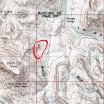
None of the three descriptions which you give from Sims Ely's book pages 8-9 are the location of where Adolph Ruth's skull and remains were located.

Someone, either Ely himself or another person helping him with his book got the location(s) wrong.

There is no doubt where Ruth's remains and skull were located and it was no where near West Boulder Canyon or the confluence of West Boulder, East Boulder and Needle Canyons.

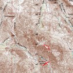
I don't have a good map with me right now with the exact pinpointed spots but the red circle is the general area where Ruth's skull and remains were located.

There is no explanation or way anyone can explain why Ely wrote what he did other than to say it is just one of MANY things in his book that was not correct.

Brownie Holmes marked on a map exactly where he had found Ruth's skull and later he added to that map where Jeff Adams said he and Tex Barkley found the rest of Ruth's remains.
The Maricopa County Sheriff's investigators confirmed those locations.
There will always be controversy but the placement by the men who actually found the remains is hard to argue with.

Ruth's skull and remeins found.jpg
 

Matthew Roberts

Bronze Member
Apr 27, 2013
1,131
4,955
Paradise Valley, Arizona
Primary Interest:
All Treasure Hunting
Cubfan64,

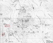
This map I believe is a Tom Kollenborn map (?) and shows the locations of where Ruth's skull and remains were located.

I circled the skull and remains sites in red.

It is the same general location as the topo I posted.

Adolph Ruth death sites map.jpg
 

cactusjumper

Gold Member
Dec 10, 2005
7,754
5,388
Arizona
I'd like to try a little experiment that may be interesting to some of you. Based on Sims Ely's description on pages 8-9 of "The Lost Dutchman Mine" I'm curious where folks think Ruth's head and body were found. Read the descriptions below, then check a topo map of the area, pinpoint the location(s) and post an image here. Try not to let anyone else's interpretation influence your decision.


The next paragraph mentions the Harvey Mott, Odd Halseth and Brownie Holmes newspaper expedition that discovered the skull...


On page 9 after discussion Hrdlicka's work on the skull, this is the description of where Ruth's body was found...


There we go - everyone to your maps and let's at least try to get everyone on the same page...

Paul,

That's a great puzzle. As you know, I have spent a good deal of time looking into those quotes. They do tend to be, somewhat, confusing.

Most would agree, I believe, that there was little chance that Ruth hiked from his camp, to where it's claimed his body and head were discovered. I believe Ruth was killed in the vicinity of the saddle where the Del Monte Claim is located between West Boulder and Little Boulder Canyons. The reasoning for the subterfuge that followed is not clear, but it may have something to do with Tex moving the remains and his motivation for doing that.

It, likely, would have been fairly easy for Ruth to hike to that location before being killed or dying from natural causes. To make the location of where he was trying get to more believable, it's possible he was shot in the head to add conviction to the story, thus locating him over in Needle Canyon, far from the actual area of real interest. That means he was shot after he was already dead.

It will be interesting to read the responses to your question.

Take care,

Joe
 

OP
OP
Cubfan64

Cubfan64

Silver Member
Feb 13, 2006
2,986
2,789
New Hampshire - USA
Detector(s) used
Fisher CZ21, Teknetics T2 & Minelab Sovereign GT
Primary Interest:
All Treasure Hunting
Cubfan64,

This map I believe is a Tom Kollenborn map (?) and shows the locations of where Ruth's skull and remains were located.

I circled the skull and remains sites in red.

It is the same general location as the topo I posted.

View attachment 1560193

Kraig - if you have the time and would indulge me, try to follow Ely's description of where Ruth's skull and body were found and post a topo map clipping of where you think that general location is - unless you feel the description isn't clear enough to interpret.
 

PotBelly Jim

Hero Member
Dec 8, 2017
899
2,989
Primary Interest:
Other
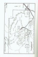
Paul, I "think" I know where you're going with this...that perhaps Ely didn't write those portions? If so, perhaps the best map to use is the one in his book...maybe the person who wrote those passages was looking at this particular map and had little to no personal experience in the mountains? Anyway, from those directions, this is what I get when using the map in Ely's book:

View attachment 1560287
 

OP
OP
Cubfan64

Cubfan64

Silver Member
Feb 13, 2006
2,986
2,789
New Hampshire - USA
Detector(s) used
Fisher CZ21, Teknetics T2 & Minelab Sovereign GT
Primary Interest:
All Treasure Hunting
Paul, I "think" I know where you're going with this...that perhaps Ely didn't write those portions? If so, perhaps the best map to use is the one in his book...maybe the person who wrote those passages was looking at this particular map and had little to no personal experience in the mountains? Anyway, from those directions, this is what I get when using the map in Ely's book:

View attachment 1560287

Excellent observation Jim!!!!
 

OP
OP
Cubfan64

Cubfan64

Silver Member
Feb 13, 2006
2,986
2,789
New Hampshire - USA
Detector(s) used
Fisher CZ21, Teknetics T2 & Minelab Sovereign GT
Primary Interest:
All Treasure Hunting
In the interest of thoroughness, here's a pic of all the locations as I understand them...

View attachment 1560307

I hope more people take the opportunity to try to follow the book directions and pinpoint on a map where Ely points out the body and skull were found.

Joe - I'm interested in your interpretation as well, and if you are willing to point out the general location of the Del Monte claim from your photo I would like to see where that is on a topo map in relation to Ely's description.

Others - please take a little time and try to follow the directions and give some feedback.

Thanks.
 

OP
OP
Cubfan64

Cubfan64

Silver Member
Feb 13, 2006
2,986
2,789
New Hampshire - USA
Detector(s) used
Fisher CZ21, Teknetics T2 & Minelab Sovereign GT
Primary Interest:
All Treasure Hunting
Cubfan64,

This map I believe is a Tom Kollenborn map (?) and shows the locations of where Ruth's skull and remains were located.

I circled the skull and remains sites in red.

It is the same general location as the topo I posted.

View attachment 1560193

Kraig - I believe that's one of Greg's maps
 

Old Bookaroo

Silver Member
Dec 4, 2008
4,318
3,510
The discovery of Ruth's skull and other remains was well covered in the newspapers of the day. As I understand it, it was a newspaper expedition that found the skull. These articles would be a logical place to search for information regarding precisely where the finds were made.

Adolf Ruth and his mysterious death in the superstition mountains of arizona, george brownie holmes, Lost Dutchman Mine of Jacob Waltz and the Peralta Sombrero Mines, Quest for Peralta Gold - A Hidden History of Red Mountain, book by John Victor Rams

As would Mr. Ruth's death certificate. A copy of that document has been offered for sale on eBay for years. I haven't read it.

I am not an expert. The story that Mr. Ruth was shot and killed seems more legend to me. It sounds too much like one of "Barry Storm's" yarns.

Good luck to all,

The Old Bookaroo
 

cactusjumper

Gold Member
Dec 10, 2005
7,754
5,388
Arizona
The discovery of Ruth's skull and other remains was well covered in the newspapers of the day. As I understand it, it was a newspaper expedition that found the skull. These articles would be a logical place to search for information regarding precisely where the finds were made.

Adolf Ruth and his mysterious death in the superstition mountains of arizona, george brownie holmes, Lost Dutchman Mine of Jacob Waltz and the Peralta Sombrero Mines, Quest for Peralta Gold - A Hidden History of Red Mountain, book by John Victor Rams

As would Mr. Ruth's death certificate. A copy of that document has been offered for sale on eBay for years. I haven't read it.

I am not an expert. The story that Mr. Ruth was shot and killed seems more legend to me. It sounds too much like one of "Barry Storm's" yarns.

Good luck to all,

The Old Bookaroo

OB,

Good to see you posting in this part of the world.

Most of us have perused the newspaper articles from the event. Part of the problem is that a great deal of deception was being disseminated. The reasoning behind that remains unclear to this day. It still goes on, as can be seen by some of the posts in this subject. Is it purposeful or just a lack of authentic knowledge.

Most of us, like myself, are just left with unqualified conjecture. Offering opinions based on hunches are not a good way to establish any semblance of the truth. There may be some people left alive out there who know the truth of the matter, but they aint talking.

Take care,

Joe Ribaudo
 

OP
OP
Cubfan64

Cubfan64

Silver Member
Feb 13, 2006
2,986
2,789
New Hampshire - USA
Detector(s) used
Fisher CZ21, Teknetics T2 & Minelab Sovereign GT
Primary Interest:
All Treasure Hunting
Just to keep things on target - the locations where Ruth's remains were actually discovered (both skull and skeleton) are fairly well known (as Matthew and Jim have presented already). I don't want to get off into the weeds (at least not yet) by bringing all that into the discussion yet.

The main gist of my question revolves around trying to decipher Ely's directions and see not only where that seems to fit on a topo map, but also whether different people interpret those directions differently.
 

Matthew Roberts

Bronze Member
Apr 27, 2013
1,131
4,955
Paradise Valley, Arizona
Primary Interest:
All Treasure Hunting
Cubfan64,

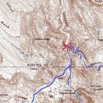
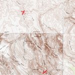
"Weaver's Needle stands amid three canyons - namely, West Boulder on the west, East Boulder in the middle, and Needle Canyon on the east. The three converge some two miles northwest of the peak, and at that point there is a mile-long ridge covered with dense brush. This ridge runs northwestward and finally loses itself in a right-angle intersection with LeBarge Canyon, which itself flows northwest to its junction with the Salt River. On this brushy ridge, the final scenes in the life of Adolph Ruth were enacted."


3 canyons converge TN1.jpg
East and West Boulder and Needle canyons converge here.

Brushy Ridge TN 1A.jpg
The brushey ridge described is all the area between the 2 red X's.


"In the thick brush overlooking West Boulder Canyon, about one hundred feet above the canyon floor, one of the dogs came upon a skull - to which particles of flesh still adhered."


Ruth's camp Willow Spring TN 2.jpg
X marks Adolph Ruth camp at Willow Spring. The red circle is the thick brush area overlooking West Boulder Canyon and also approx. area of the DelMonte mine.


"In the first week of January, 1932, Deputy Sheriff Jeff Adams of Phoenix, accompanied by Tex Barkley, did make a further search of that brushy ridge overlooking West Boulder Canyon for the body of Adolph Ruth. Their search was successful. At a considerable distance from the spot where the skull had been discovered, they found a dismembered skeleton which was easily identified."

Ruth's camp Willow Spring TN 2.jpg
Once again the same brushey ridge overlooking West Boulder Canyon.


None of the descriptions in Ely's book make any sense when matched to the actual topography of the Canyons and ridges and distances.

Matthew
 

Old Bookaroo

Silver Member
Dec 4, 2008
4,318
3,510
Cubfan64: Thank you for the explanation. While I was looking through my collection of LDM Maps (printed - none are handwritten secrets) I came across James R. Kearney's article "A Death in the Superstitions; The Fate of Adolph Ruth (The Journal of Arizona History, Summer 1992 - Vol. 33, Number 2). It's a sad commentary on several levels that I didn't remember it had been published or that I had a copy.

For the benefit of anyone interested who doesn't own a copy here's the map:

Ruth Map March 2018.jpg
[Sorry for the wrong orientation - TN takes landscape images and makes them vertical.]

Good luck to all,

The Old Bookaroo
 

Last edited:

Matthew Roberts

Bronze Member
Apr 27, 2013
1,131
4,955
Paradise Valley, Arizona
Primary Interest:
All Treasure Hunting
Cubfan64,

"Weaver's Needle stands amid three canyons - namely, West Boulder on the west, East Boulder in the middle, and Needle Canyon on the east. The three converge some two miles northwest of the peak, and at that point there is a mile-long ridge covered with dense brush. This ridge runs northwestward and finally loses itself in a right-angle intersection with LeBarge Canyon, which itself flows northwest to its junction with the Salt River. On this brushy ridge, the final scenes in the life of Adolph Ruth were enacted."


View attachment 1560571
East and West Boulder and Needle canyons converge here.

View attachment 1560573
The brushey ridge described is all the area between the 2 red X's.


"In the thick brush overlooking West Boulder Canyon, about one hundred feet above the canyon floor, one of the dogs came upon a skull - to which particles of flesh still adhered."


View attachment 1560574
X marks Adolph Ruth camp at Willow Spring. The red circle is the thick brush area overlooking West Boulder Canyon and also approx. area of the DelMonte mine.


"In the first week of January, 1932, Deputy Sheriff Jeff Adams of Phoenix, accompanied by Tex Barkley, did make a further search of that brushy ridge overlooking West Boulder Canyon for the body of Adolph Ruth. Their search was successful. At a considerable distance from the spot where the skull had been discovered, they found a dismembered skeleton which was easily identified."

View attachment 1560574
Once again the same brushey ridge overlooking West Boulder Canyon.


None of the descriptions in Ely's book make any sense when matched to the actual topography of the Canyons and ridges and distances.

Matthew


Cubfan64,

You can see that when you take the exact quotes from Ely's book and put them together with the topographic map of the actual terrain, they make little or no sense and cannot be literally followed by someone actually on the ground.

Matthew
 

Matthew Roberts

Bronze Member
Apr 27, 2013
1,131
4,955
Paradise Valley, Arizona
Primary Interest:
All Treasure Hunting
Cubfan64,

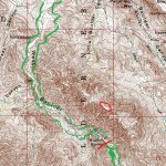
If you took the following quote from Ely's book on where Ruth's skull was found it would be somewhere within the green lines on the topo map depending on which side of West Boulder Canyon Ely was talking about.

"In the thick brush overlooking West Boulder Canyon, about one hundred feet above the canyon floor, one of the dogs came upon a skull - to which particles of flesh still adhered."


Ruth's camp Willow Spring TN 2.jpg
 

markmar

Silver Member
Oct 17, 2012
4,117
6,259
Primary Interest:
All Treasure Hunting
IMO , is clear Sims Ely was talking about the Black Top Mesa ( a mile lond ridge running NW ) , which between other canyons , overlooks at its NW end the West Boulder Canyon . The author's statement how that brushy ridge overlooks the West Boulder Canyon , don't put the ridge beside /next to that specific canyon .
Also , is clear how the author was not aware of the relief and topography of the middle-west Superstitions Mt.
 

OP
OP
Cubfan64

Cubfan64

Silver Member
Feb 13, 2006
2,986
2,789
New Hampshire - USA
Detector(s) used
Fisher CZ21, Teknetics T2 & Minelab Sovereign GT
Primary Interest:
All Treasure Hunting
Cubfan64,

If you took the following quote from Ely's book on where Ruth's skull was found it would be somewhere within the green lines on the topo map depending on which side of West Boulder Canyon Ely was talking about.

"In the thick brush overlooking West Boulder Canyon, about one hundred feet above the canyon floor, one of the dogs came upon a skull - to which particles of flesh still adhered."


View attachment 1560588

Matthew - thank you very much for indulging me with topos and markings! I sincerely appreciate the effort. I'm at work right now, but will try either tonight or one of the following nights to include my interpretations.

One thing that you address is the difficulty if not even impossibility of following Ely's directions from pages 8-9 regarding Ruth's remains location. He initially states that the "mile long ridge covered with dense brush" which starts about 2 miles NW of Weaver's Needle and continues running NW is THE brushy ridge where the final scenes of life of Adolph Ruth were enacted.

To me, later when he mentions specifics about finding the skull and skeleton on the "brushy ridge" overlooking West Boulder Canyon, the only thing I can assume is that he's describing the same "brushy ridge" that he earlier mentioned. So to me, based on the description in his book, he has to be talking about a location right along the Pinal/Maricopa county borders somewhere W, SW or NW just a little bit from where East Boulder and West Boulder merge - somewhere NW of Aylor's Caballo camp and SE of Yellow Peak.

He never introduces a "brushy ridge" anywhere near his camp at Willow Spring or the Del Monte claim - only the one that runs NW from the intersection of the canyons.

As you stated, trying to follow any of Ely's directions in this respect seems to be difficult at best and probably impossible.

Paul
 

Top Member Reactions

Users who are viewing this thread

Top