1847 site

wrmickel1

Bronze Member
Nov 7, 2011
1,854
1,392
Jamestown ND
Detector(s) used
Garrett 2500
Primary Interest:
Other
Ya know I never thought of it until now.

I believe the ORO 1847 site has a very direct connection to the Spanish Massacre Site!

After doing some research and running some compass numbers from the ORO 1847 petroglyph, the directional 90 degree's east runs right through the massacre site grounds. Could It be a clue to a storage vault that they were attempting to access with the many bags of Oro they were carrying with them? It's known the Spanish used under ground storage chambers for quick access.

This petroglyph may just be a clue to the entrance of said vault.

It's a very strong possibility.

The time frame lines up.

Agree Sir.

Supply chain heading to the Sea to be loaded and shipped on a timely manner. The Fisher family proved that with the Atocha. That's the ledgen of the Indians saying the Spanish filled the Needle with Treasure. The trail map starts at that very vault, then onto the mines in the region.

wish you the best in your hunt.

babymick1
 

wrmickel1

Bronze Member
Nov 7, 2011
1,854
1,392
Jamestown ND
Detector(s) used
Garrett 2500
Primary Interest:
Other
IMG_1851.JPG

This is what your looking for.

babymick
 

Azquester

Bronze Member
Dec 15, 2006
1,736
2,596
Primary Interest:
All Treasure Hunting
Agree Sir.

Supply chain heading to the Sea to be loaded and shipped on a timely manner. The Fisher family proved that with the Atocha. That's the ledgen of the Indians saying the Spanish filled the Needle with Treasure. The trail map starts at that very vault, then onto the mines in the region.

wish you the best in your hunt.

babymick1

Mick, Ever since I discovered the petroglyph I've been running directional and distances compass projection lines on GE Pro. Both in early Castilian feet / vara, and US standard feet / yards. Some of the outcomes have been promising:laughing7:. Who knows it may even pass over or end at the old Dutchman Mine?
It's also known that the secret canyon of gold lies in there as per Geronimo's description. Probably the same canyon or high ridge depression Waltz talked about.

It's gonna take lots of leg work to prove out any of this. I think a modern GPS should be close. From there it's a matter of looking for the proper signs. That sideways rock formation you posted I assume is normally turned. I've been all over that area many times and it has some weird formations. One would assume that the omega would mimic the alpha. So some where along that line at a certain distance would be the opposite of the petroglyph "ORO" only small in size and hidden not open.
 

wrmickel1

Bronze Member
Nov 7, 2011
1,854
1,392
Jamestown ND
Detector(s) used
Garrett 2500
Primary Interest:
Other
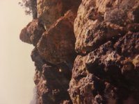
Yes, if you click on the pic it originates to the correct angle

babymick1
 

motel6.5

Sr. Member
Mar 27, 2012
355
367
Nevada,Calif.,Utah,Arizona
Primary Interest:
All Treasure Hunting
No proof,my opinons only.
1847-navigation bearing.
1-8-4-7=4 vaults
each vault has the exact number of material stored as its #,based on the old Latin,Roman,numbered system.interwoven with a Aztec codice.
Located in a pyramid surrounded by a trapazoid fortafication,possibly in a dormet volcano,thats been camaflouged.
 

Real of Tayopa

Bronze Member
Sep 4, 2016
1,942
9,101
Mexico
Primary Interest:
All Treasure Hunting
Bill, the seven with a crosbar is normal. It keeps it from confusing it with another no.
 

wrmickel1

Bronze Member
Nov 7, 2011
1,854
1,392
Jamestown ND
Detector(s) used
Garrett 2500
Primary Interest:
Other
What is your belief as to the meaning of "1847"? A distance, a date, a bible code, a name or anything else? It's just a general question. The reason I ask is because the "1847" photo I posted used a pointed "4" which can have the meaning of a triangle or a cross, or a plus "+" sign for addition, or an "X" which stands for multiply. The next numeral is "7" with a cross bar on it. a "T" or cross has a bible gematria of 23 or an "F" letter gematria reversed in the "7" which is a "7" in the Castilian bible letter codes. 18 could be the gematria for "O" or zero, or, as the 18th letter of the Castilian bible code. 8-1=7, 1+8=9X2=18. It's possible the "4" was intended as a dual symbol because the letter for that number was used as a "CH" or not at all. "4" was considered as bad as "666".


Any thoughts on this anyone?

Bill, I believe it a date. Now the four is a direction you should go.

babymick1
 

markmar

Silver Member
Oct 17, 2012
4,117
6,259
Primary Interest:
All Treasure Hunting
What is your belief as to the meaning of "1847"? A distance, a date, a bible code, a name or anything else? It's just a general question. The reason I ask is because the "1847" photo I posted used a pointed "4" which can have the meaning of a triangle or a cross, or a plus "+" sign for addition, or an "X" which stands for multiply. The next numeral is "7" with a cross bar on it. a "T" or cross has a bible gematria of 23 or an "F" letter gematria reversed in the "7" which is a "7" in the Castilian bible letter codes. 18 could be the gematria for "O" or zero, or, as the 18th letter of the Castilian bible code. 8-1=7, 1+8=9X2=18. It's possible the "4" was intended as a dual symbol because the letter for that number was used as a "CH" or not at all. "4" was considered as bad as "666".


Any thoughts on this anyone?

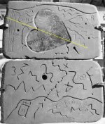
Bill , these numbers are for degrees from a constant . But are not only these . You have to use them in combination with the numbers from the bottom of the stone Trail map and a part of the numbers from the cavity of the stone Trail heart , to abtain the real degrees .
Just my theory which for me worked well .
 

markmar

Silver Member
Oct 17, 2012
4,117
6,259
Primary Interest:
All Treasure Hunting
I forgot to add something to my previous post .
If we draw a line from the constant in the direction to where the riddle shows , this line don't goes only to the treasure's cave , but also its direction , divides the imaginary Trail stone heart in two equal parts and pass above the church's site ( in the heart ) . It's amazing .

heart divide.JPG
 

Last edited:

Azquester

Bronze Member
Dec 15, 2006
1,736
2,596
Primary Interest:
All Treasure Hunting
Bill , these numbers are for degrees from a constant . But are not only these . You have to use them in combination with the numbers from the bottom of the stone Trail map and a part of the numbers from the cavity of the stone Trail heart , to abtain the real degrees .
Just my theory which for me worked well .

Check this out. Garmin's 1847 Map..

View attachment 1624643
 

wrmickel1

Bronze Member
Nov 7, 2011
1,854
1,392
Jamestown ND
Detector(s) used
Garrett 2500
Primary Interest:
Other
That's just a sorta copy of the Stones, Nothing more but a lot less then the Stones.
l'd drop that in a garbage can.

babymick1
 

markmar

Silver Member
Oct 17, 2012
4,117
6,259
Primary Interest:
All Treasure Hunting
Check this out. Garmin's 1847 Map..

View attachment 1624643

Bill , this map is reproduction of Garmin search area and what he believed was right in his own theory .

In this map we can see Garmin had used four symbols from the stone Trail map and one from the Horse stone map .
The symbol " 3 " from the Horse and Trail maps , is for " two buttes " or " two boulders " .
The dagger is to indicate a direction ( and nothing else ) in the map . In the stone Trail map shows how the Trail goes from the bottom to the top . If the dagger would pointed down , then the Trail would goes from the top to the bottom .

Now what is wrong interpreted in this map :
- The trail has a different shape/route . The real trail has the shape which is depicted in the stone trail map , and anything else is out of the map's concept .
- The heart points to the east . Because in the stone Trail map the heart points to the right , that don't means there is the east . Is wrong to take as north the upper side of a map if there is not a sign/arrow that shows that .
 

Last edited:

wrmickel1

Bronze Member
Nov 7, 2011
1,854
1,392
Jamestown ND
Detector(s) used
Garrett 2500
Primary Interest:
Other
Copied from a photo (slide) of one of Travis Tumlinson's maps ?
Just a guess.......

No one ever proved there were any Maps made by Travis, Paper, Stone or Slides, All I ever seen or heard was hearsay on the subject.

Babymick1
 

Top Member Reactions

Users who are viewing this thread

Top