1847 site

wrmickel1

Bronze Member
Nov 7, 2011
1,854
1,392
Jamestown ND
Detector(s) used
Garrett 2500
Primary Interest:
Other
sgtfdaThere is a old mine at every location on the trail stones. All located in Hewitt and Millsite Canyons. The same area Travis was visiting. What came first. The chicken or the egg. Did he first find the old mines then make the maps? Tom K said:
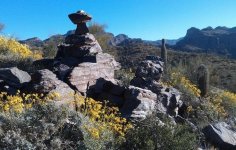
IMG_0368.JPG

This is the The marker to Hewitt Canyon Frank, notice the very unusual shaped Top., Now since the Stones are real
and you believe the theory that Travis was setting things up for a movie. And you got a hand sketched map and Travis and Garman spent a lot of time there, Which would make most believe you have a map from a Know accomplish That
you surely have the fake Map.

Travis never figured out the Real Stone Maps.

babymick1. ( I've been there Frank it's not the Canyon or the other one,)
 

deducer

Bronze Member
Jan 7, 2014
2,280
4,352
Primary Interest:
Other
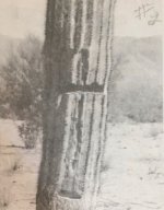
Had to do some digging, but I finally found a picture of the last of the original carved cacti before they were knocked over or otherwise destroyed in the late 1940's, early 1950's. Note the deeply cut cross.

+cactus.jpg

This photo was taken by Burbridge- the cactus in the picture is about 1.5 feet in diameter. The height wasn't given- but I would guess it's pretty old.
 

markmar

Silver Member
Oct 17, 2012
4,117
6,259
Primary Interest:
All Treasure Hunting
Had to do some digging, but I finally found a picture of the last of the original carved cacti before they were knocked over or otherwise destroyed in the late 1940's, early 1950's. Note the deeply cut cross.

View attachment 1628808

This photo was taken by Burbridge- the cactus in the picture is about 1.5 feet in diameter. The height wasn't given- but I would guess it's pretty old.


Deducer

This is a pointing sign cross . Someone had to go in the direction the cross pointed . The lower " arm " shows how afar is the target . Going closer to the target , the lower arm get smaller till all the arms are equal . From that point you are about 200 feet afar from the target and you have to follow different signs ( usually carved on rocks ) to find it .
 

ink

Full Member
Mar 22, 2018
158
50
Primary Interest:
All Treasure Hunting
Thanks sgtda. please contact a movie production company
 

Doc4261

Hero Member
Nov 5, 2015
582
578
Primary Interest:
All Treasure Hunting
The knife in the stone maps does not mean danger. The knife means there is a birthday cake at the end of the trail.

The Dagger is the key to the 2nd part of the trail map. Figure that out and u have figured out the hidden heart and where the latin heart is located. It is overlooked by so many and why it hasn't been solved. Good hunting. PS. keep on your hunt if u don't have the exact place. U are close to the ldm solve if that is all u are looking for. Its a big area out there..
 

OldManOfTheRiver

Full Member
Jun 15, 2018
217
457
Tennessee
Primary Interest:
Other
The Dagger is the key to the 2nd part of the trail map. Figure that out and u have figured out the hidden heart and where the latin heart is located. It is overlooked by so many and why it hasn't been solved. Good hunting. PS. keep on your hunt if u don't have the exact place. U are close to the ldm solve if that is all u are looking for. Its a big area out there..

Thanks Doc. It's gonna be fun even if I have to drag my girl up there. :coffee2: Hope everyone has a good day. Gotta get these packs put together. It's fun to chat over coffee though!!
 

Doc4261

Hero Member
Nov 5, 2015
582
578
Primary Interest:
All Treasure Hunting
Thanks Doc. It's gonna be fun even if I have to drag my girl up there. :coffee2: Hope everyone has a good day. Gotta get these packs put together. It's fun to chat over coffee though!!


My trip is Dec 1. will go into the sups for 4 days, then off north to one of the mines on the LH still covered. This is the mine next to caucumen. "high point" in the LH. If I have time. Going after a lost tourmaline mine near Wickenberg also. This one should be found in 2 days and a bit of grunt work. Know where it is within 5 feet. Lots to do in 10 days. View attachment 1644784
 

Last edited:

OldManOfTheRiver

Full Member
Jun 15, 2018
217
457
Tennessee
Primary Interest:
Other
My trip is Dec 1. will go into the sups for 4 days, then off north to one of the mines on the LH still covered. This is the mine next to caucumen. "high point" in the LH. If I have time. Going after a lost tourmaline mine near Wickenberg also. This one should be found in 2 days and a bit of grunt work. Know where it is within 5 feet. Lots to do in 10 days. View attachment 1644784

That's awesome man!
 

Holyground

Hero Member
May 17, 2014
579
828
Not in the can
Detector(s) used
Garrett AT GOLD, Garrett ATX
Primary Interest:
All Treasure Hunting
Check this out. Garmin's 1847 Map..

View attachment 1624643

A real treasure map has a definite starting point, clues all inbetween, and a definite ending point. So, tell me where we start? Is the doubleline with the dotted lines the Apache Trail Highway? Cool, it leads right to the 1847 Heart which surely is the treasure we seek. I'll meet you at the museum then we will set out on possibly the greatest adventure the world has ever known! Let's take a picnic.
 

Holyground

Hero Member
May 17, 2014
579
828
Not in the can
Detector(s) used
Garrett AT GOLD, Garrett ATX
Primary Interest:
All Treasure Hunting
The knife with the D stands for Demarcacion. Demarcation line, where the bottom map sits in relation to the ground, at the Gila River. It's all insideout, wrongside in, upside down and backwards. That's why we can't find it. We can't think like a twisted Jesuit.
 

OP
OP
sgtfda

sgtfda

Bronze Member
Feb 5, 2004
2,350
3,880
Mesa Arizona
A real treasure map has a definite starting point, clues all inbetween, and a definite ending point. So, tell me where we start? Is the doubleline with the dotted lines the Apache Trail Highway? Cool, it leads right to the 1847 Heart which surely is the treasure we seek. I'll meet you at the museum then we will set out on possibly the greatest adventure the world has ever known! Let's take a picnic.

That is Millsite Csmyon. Garmans area
 

Top Member Reactions

Users who are viewing this thread

Latest Discussions

Top