Now that the stone maps are out of the way, no movie/series....what's next?

markmar

Silver Member
Oct 17, 2012
4,117
6,259
Primary Interest:
All Treasure Hunting
Yes it is. And it's a popular video on several youtube sites.
Where do you think the producers got the "sacred cave" story from ?
So is "Lust for Gold" BTW
I still mean to have a look out there at the place where the scene of the "Peralta" map on the rock was shot.
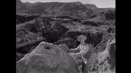
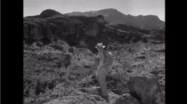
If any trace of it remains, it should be possible to find it by using this still I saved.....
Someone else added the red jif outlines.

View attachment 1670626

Be a fun search......maybe Wayne T. and Frank would join me in that.

This still is better.....

View attachment 1670627


Wayne

The mine which is connected with the " Manuel " map from the movie and the symbols on the Black Top Mesa , I have showed it ( an GE image ) in the post #55 at http://www.treasurenet.com/forums/lost-dutchman-s-mine/575184-stone-maps-their-concept-4.html
See , then Frank denied any interest in searching , but maybe with you he would has different opinion . The symbols on the mountain are a general indication to the mine , but together with the Manuel map , they have the whole meaning .
 

Last edited:

somehiker

Silver Member
May 1, 2007
4,365
6,426
Primary Interest:
All Treasure Hunting
Maybe this is why the sacred cave was named and CAVERNA AURUM ( golden cavity ) .

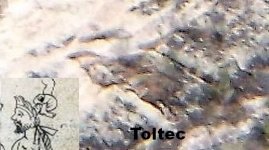
Same idea has occurred to me as well, in that there appears to be an opening upslope from the "Toltec like" image I've labeled in the post above.
 

coazon de oro

Bronze Member
May 7, 2010
1,623
3,858
texas
Primary Interest:
All Treasure Hunting
Homar,

Two thoughts, but let me preface them with my belief that what separates a really good investigator from an average one is guarding against the temptation to assume, to think you know, or to assume you know what happened. This is a lesson that I've had to learn again and again, not just research-wise, but also out in the field. I had been looking for a set of symbols in an area of interest and had completely overlooked a bluff that was right in front of me because it was one of the first areas that I had checked out while becoming acquainted with the area, and somehow my mind had just put a checkmark on that area and I neglected the realization that while it was the first I had explored, I had not searched it thoroughly, and for the symbols I was looking for.

You state that you doubt that Pegleg Tumlinson left his descendants anything, and anything contrary to that is an assumption. Why is that so? Is there anything that conclusively proves that Pegleg left his family nothing?

And as far as the neighborhood kids leaving their names on exposed sandstone, that may have been true, but Travis went way beyond that. He carved on the chimney of the family cabin, he carved a stone with a galleon on one side and a treasure chest on the other- and Garry, on the other site, made a good argument for the similarity of the lettering characteristics as far as this stone, and the H/P Stone Map. With the detailed comparison, Garry much pushes this tale beyond the realms of sheer coincidence. There was at least sort of inspiration if nothing else.

One other thing to consider- the Superstitions are not on the way from Texas to Oregon. They are a serious detour. And even if we were to suppose that Travis wanted to vary how he got back and forth between Oregon and Texas, and decided to go via Phoenix, he would have taken what today exists as the well known I-10 which passes through Tucson on its way up to Phoenix. While you still can see the Superstitions while driving north on I-10 (I have) they don't really stand out from any of the mountain ranges in that area, IMO.
Howdy deducer,

You question my opinion of doubting that Peg Leg left nothing related to the PSM's after I showed you how the assumptions that he did, came about. It was assumed that because he was a treasure hunter, he may have left something behind. It was assumed because of a fake diary put him searching in Arizona, and it was assumed because of a fake map created by Robert Tumlinson. A good investigator would question those assumptions instead of my opinion.

Peg Leg Tumlinson was from my neck of the woods. I have been to Espantosa Lake many times where he dug for treasure. In fact I have walked from Eagle Pass to Carrizo Springs, not in one day, but checking pipeline right of way. I have also been over it by plane, and chopper. I know every ranch around his stomping grounds. My wife grew up in what once was the Olmos Ranch where Peg Leg also dug for treasure. The largest rattler I have ever killed was on Estambel hill where Peg Leg searched. I was never in those places because Peg Leg dug there, I found out later that he did. I would go fishing on Espantosa Lake, and I hunted deer and arrowheads on the old Olmos Ranch. Now that I have an interest in treasure hunting, I want to go back to Estambel hill because of a story my wife told me out of the blue about a light they saw there one night while hog hunting.

One night my wife's dad, mom, and brother, and sister were sitting in the truck waiting for wild hogs to come to a cattle feeder in the pens of that hill (the old corral was replaced with oil field pipe). When they started to hear the hogs coming in, and were getting prepared with the spotlight, a light appeared. She said it didn't shine on them, or on anything like a spotlight, or car light, but that it looked round and bright like a car light. Needless to say, they got out of there. She said she remembers exactly where that light appeared, and I would like to check it out with a two box some day. The camino real from Laredo to San Antonio passed in front of the house my wife grew up in, as it makes it's way to the old Fort Ewell. That house is by a spring on the West side of Olmos creek.

Anyway, I have nothing against Peg Leg, or any Tumlinson, I just don't see anything that would put him in Arizona, or him having any waybill to the PSM's. Not even the Mexicans could find them, so how could they show anyone else how to find them, and why would they, it makes no sense.

As far as the chimney, carving your name once is enough. That was private property where only he could kill time. That chimney was a wall of inviting sandstone, after his name, he could only carve other things. The treasure chest/galleon stone was carved from his fascination of the PSM's.

Garry Cundiff is a great investigator, I have nothing but respect for him, and his work from which I have learned a lot. However, he is only human, capable of mistakes as we all are. His mistake was beyond his knowledge of the Spanish language. While you may say he fell to the temptation to assume, therefore he is not a great investigator, I just see it as simple lack of knowledge of the Spanish language which takes nothing away from his investigating skills.
The treasure chest/galleon stone only proves Travis's fascination of the PSM's, and his ignorance of the Spanish language. It proves Travis was not capable of having made the PSM's. This is not an assumption, it is a fact, and when you ignore the facts, you lose your credibility as an investigator.

I see no reason to question the route Travis took on his way to Texas, for there could be many. Quien sabe? Kemosabe!

Homar
 

coazon de oro

Bronze Member
May 7, 2010
1,623
3,858
texas
Primary Interest:
All Treasure Hunting
On the other site, if you will recall- from the thread on Travis Tumlinson and the Stone Maps, while Janie did tell Larry that Travis "carved them" (and Larry was quite taken aback), we must remember that Janie also told another person that her father "in no way, hoaxed the Stone Maps."

So this is an interesting contradiction. What are we to make of it? Does there exist a scenario where both statements could be truthful? It's an interesting thing to think about.

Howdy deducer,

She may have been led to believe that Travis carved them, and later found by Travis's own words that he did find them. It really doesn't matter what she said, or why if you know the stone maps are real does it? Forget about what so and so said, solve them and you will find who was blowing smoke.

Homar
 

wrmickel1

Bronze Member
Nov 7, 2011
1,854
1,392
Jamestown ND
Detector(s) used
Garrett 2500
Primary Interest:
Other
Same idea has occurred to me as well, in that there appears to be an opening upslope from the "Toltec like" image I've labeled in the post above.

Somehiker, what's a Toltec image, I got a chisel image I wondered if it might of been Aztec or something like that. Well I'll post it.


IMG_2639.JPG

Give me me a meaning to it, just wondering what it might mean.

Babymick1
 

somehiker

Silver Member
May 1, 2007
4,365
6,426
Primary Interest:
All Treasure Hunting
Wayne

The mine which is connected with the " Manuel " map from the movie and the symbols on the Black Top Mesa , I have showed it ( an GE image ) in the post #55 at http://www.treasurenet.com/forums/lost-dutchman-s-mine/575184-stone-maps-their-concept-4.html
See , then Frank denied any interest in searching , but maybe with you he would has different opinion . The symbols on the mountain are a general indication to the mine , but together with the Manuel map , they have the whole meaning .

The symbols on the rocks in the movie scene AND the "Manuel" map used in LFG were created for the movie.....thus fake and only props.
Also....the peak pointed to and called "Weavers Needle" in the scene is not WN, but rather a much shorter peak which served the producer's purpose.
It's all a long way from WN and Black Top.
 

somehiker

Silver Member
May 1, 2007
4,365
6,426
Primary Interest:
All Treasure Hunting
Somehiker, what's a Toltec image, I got a chisel image I wondered if it might of been Aztec or something like that. Well I'll post it.


View attachment 1670961

Give me me a meaning to it, just wondering what it might mean.

Babymick1

Your object, if man-made, could be some kind of animal. Even if natural, it could still be seen as such .

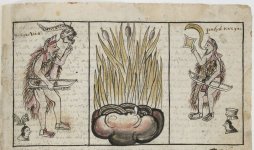
The two Toltecs dignitaries meeting with their Chichimec counterparts in the Historia Tolteca-Chichimeca were portrayed by the Aztec artist/scribes, mainly Priests, as wearing a tiara-like headdress at the time of their request for assistance from the Chichimecas. At the time when the HTC was created, 1545-65, the Toltec empire had long ceased to exist, leaving behind no art or writing other than what remains on the walls of the ruins at Teotehuacan, Tula, and a couple of other places. So where did the creators of the HTC see what they may have later incorporated into the visual aspects of how they portrayed the scenarios used within the pages of the Historia ? Was it here ???
The photo I posted is only a suggestion that it might be that it was....

063 Toltec.jpg

Historia_Tolteca-Chichimeca__btv1b84559448.jpg

The Aztec claim they are descended from the Toltec.
Who at one time were skin and tiara wearing bearded Chichimecas who had left the area centuries before ?
 

Last edited:

markmar

Silver Member
Oct 17, 2012
4,117
6,259
Primary Interest:
All Treasure Hunting
The symbols on the rocks in the movie scene AND the "Manuel" map used in LFG were created for the movie.....thus fake and only props.
Also....the peak pointed to and called "Weavers Needle" in the scene is not WN, but rather a much shorter peak which served the producer's purpose.
It's all a long way from WN and Black Top.

I was not talking about the symbols from the movie , but those on Black Top . And I knew the WN in the movie was not the real one , OMG .
 

deducer

Bronze Member
Jan 7, 2014
2,281
4,360
Primary Interest:
Other
So is "Lust for Gold" BTW
I still mean to have a look out there at the place where the scene of the "Peralta" map on the rock was shot.
If any trace of it remains, it should be possible to find it by using this still I saved.....
Someone else added the red jif outlines.

View attachment 1670626


Be a fun search......maybe Wayne T. and Frank would join me in that.

This still is better.....

View attachment 1670627


I get the impression, from a cursory look at the movie, that they shot the majority of their exteriors around Horse Mesa.
 

markmar

Silver Member
Oct 17, 2012
4,117
6,259
Primary Interest:
All Treasure Hunting
Same idea has occurred to me as well, in that there appears to be an opening upslope from the "Toltec like" image I've labeled in the post above.

Don't forget there you have to pass a ECCLESIA . Whatever opening without this clue , is just an opening .
 

Cubfan64

Silver Member
Feb 13, 2006
2,986
2,789
New Hampshire - USA
Detector(s) used
Fisher CZ21, Teknetics T2 & Minelab Sovereign GT
Primary Interest:
All Treasure Hunting
I get the impression, from a cursory look at the movie, that they shot the majority of their exteriors around Horse Mesa.

I think Coronado Mesa and west of there is a little closer - not sure though.
 

deducer

Bronze Member
Jan 7, 2014
2,281
4,360
Primary Interest:
Other
I think Coronado Mesa and west of there is a little closer - not sure though.

s2.jpg

Isn't that Fish Creek canyon down there in this shot? Coronado Mesa would be on the other side, since you can see the eastern side of the famous Superstition Mountains profile in the far distance.
 

markmar

Silver Member
Oct 17, 2012
4,117
6,259
Primary Interest:
All Treasure Hunting
Paul is right . The place is just NE from Mesquite Flats
 

Cubfan64

Silver Member
Feb 13, 2006
2,986
2,789
New Hampshire - USA
Detector(s) used
Fisher CZ21, Teknetics T2 & Minelab Sovereign GT
Primary Interest:
All Treasure Hunting
View attachment 1671097

Isn't that Fish Creek canyon down there in this shot? Coronado Mesa would be on the other side, since you can see the eastern side of the famous Superstition Mountains profile in the far distance.

Yes I believe that's Fish Creek Canyon, but my gut tells me this shot was taking somewhere either on Coronado Mesa or a short distance up Black Cross Butte. Horse Mesa should be on the far left side of the shot off screen on the east side of Fish Creek Canyon right?

I have a photo or two I'll see if I can find tonight to post.
 

deducer

Bronze Member
Jan 7, 2014
2,281
4,360
Primary Interest:
Other
Yes I believe that's Fish Creek Canyon, but my gut tells me this shot was taking somewhere either on Coronado Mesa or a short distance up Black Cross Butte. Horse Mesa should be on the far left side of the shot off screen on the east side of Fish Creek Canyon right?

I have a photo or two I'll see if I can find tonight to post.

Paul,

Here is a pan of the same shot- a long pan to the left which ends in this shot:

tortilla.jpg

That's Tortilla mountain in the distance if I'm not mistaken.
 

somehiker

Silver Member
May 1, 2007
4,365
6,426
Primary Interest:
All Treasure Hunting
I was not talking about the symbols from the movie , but those on Black Top . And I knew the WN in the movie was not the real one , OMG .

OK....I thought you were, since you were replying to what I had said about looking for the rocks that were in the movie.
I know the symbols on Black Top are similar......don't know about the "tadpole" though, but many "tanks" are full of them in April/May.

Wayne

The mine which is connected with the " Manuel " map from the movie and the symbols on the Black Top Mesa , I have showed it ( an GE image ) in the post #55 at http://www.treasurenet.com/forums/lost-dutchman-s-mine/575184-stone-maps-their-concept-4.html
See , then Frank denied any interest in searching , but maybe with you he would has different opinion . The symbols on the mountain are a general indication to the mine , but together with the Manuel map , they have the whole meaning .
 

somehiker

Silver Member
May 1, 2007
4,365
6,426
Primary Interest:
All Treasure Hunting
Yes I believe that's Fish Creek Canyon, but my gut tells me this shot was taking somewhere either on Coronado Mesa or a short distance up Black Cross Butte. Horse Mesa should be on the far left side of the shot off screen on the east side of Fish Creek Canyon right?

I have a photo or two I'll see if I can find tonight to post.

Yes....SE corner of BCB, about where the first crevasse is that we climbed up through, on our way to the top one day about 12-13 years ago.
If the symbols were done with grease crayon or black paint, they're probably faded by now....maybe even removed by Storm after the shoot was in the can.
 

somehiker

Silver Member
May 1, 2007
4,365
6,426
Primary Interest:
All Treasure Hunting
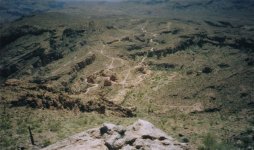
Here's a shot from way up above.....

BCB_down.jpg

Some of the scenes from the "Legends" series were shot down there and nearby, as well as the "village" scene in "The Bridge".
There is also a set of cart tracks deeply worn in solid rock and part way down the slope into FC Canyon. Problem is, no one is allowed past the gate across the road nowadays, so you can't hike down there to see them.
 

Last edited:

Top Member Reactions

Users who are viewing this thread

Top