DEERING CANYON AND GOOGLE EARTH

EDN

Jr. Member
Apr 17, 2016
46
110
Gilbert, Arizona
Detector(s) used
Minelab Eureka Gold
Primary Interest:
All Treasure Hunting
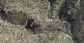
It's most likely a shadow. Look at this view with at a different time of day.
view01.jpg
 

OP
OP
skyhawk1251

skyhawk1251

Sr. Member
Nov 9, 2018
312
669
Kingman, AZ
Detector(s) used
Fisher Gold Bug Pro
Primary Interest:
Prospecting
Thanks to all for the replies and interest in this post. Another image of the strange surface feature is provided here, Google Earth again, but viewed from a different compass direction.

0007.jpg

From this angle, two pits are visible. The larger pit seems to have an excavated "ramp" leading to its bottom to make access easier.

Now, for an added "bonus", here's more interesting Google Earth images of Deering Canyon. The pushpin marks the location of Robert Kesselring's candidate site for the Lost Dutchman mine.

0004.jpg

And a zoomed view below. Notice the ledge on the right, covered by the overhanging cliff face. On the left, notice the outflow of dirt/rocks from what looks like a natural "tunnel." Below, on the canyon floor, are potholes, or "tubs", in the bedrock, that will act as basins to catch rainwater. Very interesting geological formations, worthy of exploration, even if it is not a prime site for the Lost Dutchman Mine. Some boots-on-the-ground photos of these things would be appreciated.

0006.jpg
 

Al D

Bronze Member
Jul 23, 2011
2,066
3,524
Gold canyon AZ
Detector(s) used
DJI Air 2S
Primary Interest:
Cache Hunting
Looks like this one, may be the same spot, as I recall, the Apache filled in many of the Peralta mines, the area left of the hole looks filled in to me.
 

Attachments

  • D1137ED4-76DA-46C6-B368-390FF28A2DCB.jpeg
    D1137ED4-76DA-46C6-B368-390FF28A2DCB.jpeg
    445.7 KB · Views: 192
Last edited:

Top Member Reactions

Users who are viewing this thread

Top