DEERING CANYON AND GOOGLE EARTH

skyhawk1251

Sr. Member
Nov 9, 2018
311
669
Kingman, AZ
Detector(s) used
Fisher Gold Bug Pro
Primary Interest:
Prospecting
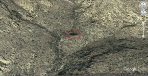
I've been rereading "The Bible on the Lost Dutchman Gold Mine and Jacob Waltz", by Helen Corbin, and I decided to do some more close scrutiny of Deering Canyon using Google Earth. I know from my own on-the-ground explorations of Mohave County, Arizona that what is seen on Google Earth does not closely approximate what is seen walking the trails, but Google Earth is a great tool for the armchair traveler. While doing some no-sweat research, I found something interesting in an upper portion of Deering Canyon.
009.jpg

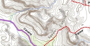
In the image above, the blue line marks a do-it-yourself trail through Deering Canyon. The strange feature I see in the upper canyon is located where the contour lines begin to be spaced farther apart as elevation is gained. The feature appears as a dark spot on the ground. It is enclosed by an ellipse.
002.jpg

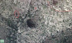
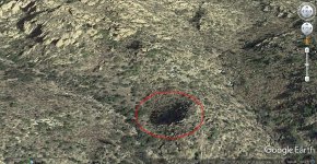
Below is a zoomed view of the same feature.
008.jpg

The ground appears to have subsided at this site, making a depression roughly circular in shape. The dark color of the depression seems to be mostly due to a solid carpet of vegetation, which could indicate that the ground was disturbed in the past. These aspects are essentially what would be expected if a large pit had been excavated, then filled-in. The landscape in the near vicinity of the depression is what fits the definition of a rincon -- a small, secluded valley.

This is a fascinating feature, and I'm not claiming that it is the pit mine that is described in the tales of the Lost Dutchman Gold Mine. I do know that people have walked past it, but not much information of any kind can be found that documents trips through Deering Canyon. If anyone has explored this general area, please share your observations.
 

A2coins

Gold Member
Dec 20, 2015
33,807
42,606
Ann Arbor
🏆 Honorable Mentions:
3
Detector(s) used
Equinox 800
Primary Interest:
All Treasure Hunting
Wow that's very interesting. give it time
 

A2coins

Gold Member
Dec 20, 2015
33,807
42,606
Ann Arbor
🏆 Honorable Mentions:
3
Detector(s) used
Equinox 800
Primary Interest:
All Treasure Hunting
Welcome to tnet I would be willing to spend years searching for that mine.. Tommy
 

Oddjob

Silver Member
Aug 23, 2012
4,348
9,067
Detector(s) used
RD1000, GSSI Profiler EMP-400. GPZ 14 & 19
Primary Interest:
Other
Welcome to Tnet,

Stick around, I would not be shocked if a few users here have been to that exact spot and even have pictures.
 

coazon de oro

Bronze Member
May 7, 2010
1,623
3,856
texas
Primary Interest:
All Treasure Hunting
I've been rereading "The Bible on the Lost Dutchman Gold Mine and Jacob Waltz", by Helen Corbin, and I decided to do some more close scrutiny of Deering Canyon using Google Earth. I know from my own on-the-ground explorations of Mohave County, Arizona that what is seen on Google Earth does not closely approximate what is seen walking the trails, but Google Earth is a great tool for the armchair traveler. While doing some no-sweat research, I found something interesting in an upper portion of Deering Canyon.

View attachment 1650552

In the image above, the blue line marks a do-it-yourself trail through Deering Canyon. The strange feature I see in the upper canyon is located where the contour lines begin to be spaced farther apart as elevation is gained. The feature appears as a dark spot on the ground. It is enclosed by an ellipse.

View attachment 1650553

Below is a zoomed view of the same feature.

View attachment 1650554

The ground appears to have subsided at this site, making a depression roughly circular in shape. The dark color of the depression seems to be mostly due to a solid carpet of vegetation, which could indicate that the ground was disturbed in the past. These aspects are essentially what would be expected if a large pit had been excavated, then filled-in. The landscape in the near vicinity of the depression is what fits the definition of a rincon -- a small, secluded valley.

This is a fascinating feature, and I'm not claiming that it is the pit mine that is described in the tales of the Lost Dutchman Gold Mine. I do know that people have walked past it, but not much information of any kind can be found that documents trips through Deering Canyon. If anyone has explored this general area, please share your observations.

Welcome to T-Net Skyhawk,

I too have wondered if this is the pit mine that Silas Haywood described to John Kochera. It seems to fit the directions, and it is a small hill. It also measures 75 feet across just as the pit mine is suppose to have been. I was thinking about showing this to a friend by pm, glad you pointed that out. While I don't believe that it is the LDM, I do believe that it is the pit mine with the tunnel below. One account says that the tunnel is on the South side of the hill, but the West side seems closer to what may be the pit above.

Homar
 

markmar

Silver Member
Oct 17, 2012
4,117
6,259
Primary Interest:
All Treasure Hunting
Hi Skyhawk

Welcome to the forum and to the topic .
In the first topo map you posted , the blue dots are for water , but this don't means someone don't can make a '" do-it yourself " trail through the mouth of Deering's canyon .
Deering canyon was searched " to death " so to speak , from the early 20 century till today . First was searched for the LDM and after for the Haywood mine . About 300 yards downward from the spot you have mentioned in your post , there is a camp ground which was used by Roy Bradford , Al Reser and Matthew Roberts , along with many others who accompanied them . If there would been a mine in that canyon , for sure it would been discovered .
I believe the confusion of a rich mine to be there , was the fact that the name " Deering " was mistakely given to that canyon . That is not the canyon Deering came through , always IMO .
 

Last edited:

Azquester

Bronze Member
Dec 15, 2006
1,736
2,596
Primary Interest:
All Treasure Hunting
I've been rereading "The Bible on the Lost Dutchman Gold Mine and Jacob Waltz", by Helen Corbin, and I decided to do some more close scrutiny of Deering Canyon using Google Earth. I know from my own on-the-ground explorations of Mohave County, Arizona that what is seen on Google Earth does not closely approximate what is seen walking the trails, but Google Earth is a great tool for the armchair traveler. While doing some no-sweat research, I found something interesting in an upper portion of Deering Canyon.

View attachment 1650552

In the image above, the blue line marks a do-it-yourself trail through Deering Canyon. The strange feature I see in the upper canyon is located where the contour lines begin to be spaced farther apart as elevation is gained. The feature appears as a dark spot on the ground. It is enclosed by an ellipse.

View attachment 1650553

Below is a zoomed view of the same feature.

View attachment 1650554

The ground appears to have subsided at this site, making a depression roughly circular in shape. The dark color of the depression seems to be mostly due to a solid carpet of vegetation, which could indicate that the ground was disturbed in the past. These aspects are essentially what would be expected if a large pit had been excavated, then filled-in. The landscape in the near vicinity of the depression is what fits the definition of a rincon -- a small, secluded valley.

This is a fascinating feature, and I'm not claiming that it is the pit mine that is described in the tales of the Lost Dutchman Gold Mine. I do know that people have walked past it, but not much information of any kind can be found that documents trips through Deering Canyon. If anyone has explored this general area, please share your observations.

Welcome to the Forum Skyhawk. I believe what you're seeing is a play on angles of the Satellite Image. Utilizing earlier historical images the spot that on the surface looks to be a depression is actually two raised outcrops of stone. In this 2011 google image of the same area you can pan around and see just that. What is interesting though is the areas of disturbed dirt that looks to be prospects along the small wash leading up to the area you posted.

Here's a picture of that same area:

View attachment 1650669

You can see the round depression has all but vanished in this angled shot. If you google that same area hit your view historical and pan back a ways. If gives different angles of the satellite and also shows less vegetation from the height of the drought we had back then. I use historical images as they are taken during different times of the days or year. It gives you a better view of the areas in question.
 

OP
OP
skyhawk1251

skyhawk1251

Sr. Member
Nov 9, 2018
311
669
Kingman, AZ
Detector(s) used
Fisher Gold Bug Pro
Primary Interest:
Prospecting
Thank you for the reply. As you point out, Google Earth can play a lot of tricks on people, and it's no substitute for boots on the ground. Google Earth is only useful for finding how to get to a location, and for getting a vague idea of what terrain might be encountered. I know that from personal experience based on my desert roamings.
 

OP
OP
skyhawk1251

skyhawk1251

Sr. Member
Nov 9, 2018
311
669
Kingman, AZ
Detector(s) used
Fisher Gold Bug Pro
Primary Interest:
Prospecting
Can you share the name, or location, of the canyon that you think Deering passed through? BTW, in reading the accounts contained in Helen Corbin's book, the "rich mines" seem to be three in number; two pit mines, and one shaft mine. I'm sure there were other sites mined by Mexicans, other than the "rich mines."
 

markmar

Silver Member
Oct 17, 2012
4,117
6,259
Primary Interest:
All Treasure Hunting
Can you share the name, or location, of the canyon that you think Deering passed through? BTW, in reading the accounts contained in Helen Corbin's book, the "rich mines" seem to be three in number; two pit mines, and one shaft mine. I'm sure there were other sites mined by Mexicans, other than the "rich mines."

IMO , there are more than three rich mines in the Superstitions . I could say , you can count them with the fingers of both hands .
To find the real Deering's trail and canyon is not so difficult if you have read the books concerned LDM and kept bits from them which could match Deering's trail description ( told by Deering ) . Many who have read these books can imagine where the Deering's trail lies .
Keep in your mind how that place was researched by some Dutch mine hunters for a long time , without finding the mine that Deering had described .
 

Last edited:

Azquester

Bronze Member
Dec 15, 2006
1,736
2,596
Primary Interest:
All Treasure Hunting
Can you share the name, or location, of the canyon that you think Deering passed through? BTW, in reading the accounts contained in Helen Corbin's book, the "rich mines" seem to be three in number; two pit mines, and one shaft mine. I'm sure there were other sites mined by Mexicans, other than the "rich mines."

I'm no expert and I had to dig up Helen's Bible from my archives but it seems to me Deering was talking about Fish Creek Canyon which is a God awful place to be. It's about a mile or two from the salt river and horrible country. It has a desert surrounding it and gold has been found around there.


View attachment 1650773

Just a guess.
 

CRobertsAZ

Newbie
Nov 10, 2018
3
8
Phoenix, AZ.
Primary Interest:
Prospecting
I've been rereading "The Bible on the Lost Dutchman Gold Mine and Jacob Waltz", by Helen Corbin, and I decided to do some more close scrutiny of Deering Canyon using Google Earth. I know from my own on-the-ground explorations of Mohave County, Arizona that what is seen on Google Earth does not closely approximate what is seen walking the trails, but Google Earth is a great tool for the armchair traveler. While doing some no-sweat research, I found something interesting in an upper portion of Deering Canyon.

View attachment 1650552

In the image above, the blue line marks a do-it-yourself trail through Deering Canyon. The strange feature I see in the upper canyon is located where the contour lines begin to be spaced farther apart as elevation is gained. The feature appears as a dark spot on the ground. It is enclosed by an ellipse.

View attachment 1650553

Below is a zoomed view of the same feature.

View attachment 1650554

The ground appears to have subsided at this site, making a depression roughly circular in shape. The dark color of the depression seems to be mostly due to a solid carpet of vegetation, which could indicate that the ground was disturbed in the past. These aspects are essentially what would be expected if a large pit had been excavated, then filled-in. The landscape in the near vicinity of the depression is what fits the definition of a rincon -- a small, secluded valley.

This is a fascinating feature, and I'm not claiming that it is the pit mine that is described in the tales of the Lost Dutchman Gold Mine. I do know that people have walked past it, but not much information of any kind can be found that documents trips through Deering Canyon. If anyone has explored this general area, please share your observations.


skyhawk1251,

I have been in this area of Deering canyon and know the area fairly well. You did not pinpoint the location of the strange feature on your topo map but said it is located where the contour lines begin to be spaced farther apart as elevation is gained. I know where the strange feature is located and it is a little further up Deering canyon almost at the Bradford, Reser, Roberts camp. If you look close at your Google Earth photo you will see the strange feature is located only about 150-200 feet from the beginning of the west edge of what is known as hill 3661. You can measure the distance because there are several saguaro cactus in the photo I recognize that are 15-30 feet tall. The area has several tunnels and shafts from previous prospecting. Deering canyon was named by Crazy Jake sometime in the 1960's and he named it for what was believed to be a Deering trail monument in the upper part of the canyon not far from your strange feature.
 

CRobertsAZ

Newbie
Nov 10, 2018
3
8
Phoenix, AZ.
Primary Interest:
Prospecting
skyhawk1251,

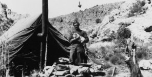
A photo of Roy Bradford in his Deering Canyon camp with his cat Plato. The arrow in the photo points to the area where what is believed to be one of the 5 Deering monuments on a ridge overlooking Deering Canyon. Al Reser took the photo of Bradford and marked the monument area with an arrow. Later Al used Bradford's camp for his searches. Bradford's camp is a stone throw away from your strange feature.

Roy Bradford Deering Canyon monument.JPG
 

OP
OP
skyhawk1251

skyhawk1251

Sr. Member
Nov 9, 2018
311
669
Kingman, AZ
Detector(s) used
Fisher Gold Bug Pro
Primary Interest:
Prospecting
skyhawk1251,

I have been in this area of Deering canyon and know the area fairly well. You did not pinpoint the location of the strange feature on your topo map but said it is located where the contour lines begin to be spaced farther apart as elevation is gained. I know where the strange feature is located and it is a little further up Deering canyon almost at the Bradford, Reser, Roberts camp. If you look close at your Google Earth photo you will see the strange feature is located only about 150-200 feet from the beginning of the west edge of what is known as hill 3661. You can measure the distance because there are several saguaro cactus in the photo I recognize that are 15-30 feet tall. The area has several tunnels and shafts from previous prospecting. Deering canyon was named by Crazy Jake sometime in the 1960's and he named it for what was believed to be a Deering trail monument in the upper part of the canyon not far from your strange feature.

When I took screenshots to capture the Google Earth images, I centered the hand cursor over the strange surface feature, so its lat/long should be readable at the bottom of the zoomed image, if the image is downloaded, and a good image editor/viewer is used to see the details. From what you wrote, the feature is real, and is not a trick of light and shadow. When you were in Deering Canyon did this feature standout from the surrounding landscape and make you take notice of it?
 

OP
OP
skyhawk1251

skyhawk1251

Sr. Member
Nov 9, 2018
311
669
Kingman, AZ
Detector(s) used
Fisher Gold Bug Pro
Primary Interest:
Prospecting
I'm no expert and I had to dig up Helen's Bible from my archives but it seems to me Deering was talking about Fish Creek Canyon which is a God awful place to be. It's about a mile or two from the salt river and horrible country. It has a desert surrounding it and gold has been found around there.


View attachment 1650773

Just a guess.

The Fish Creek location for a "rich mine" agrees with the tale of Two Soldiers recounted in Helen Corbin's book.
 

CRobertsAZ

Newbie
Nov 10, 2018
3
8
Phoenix, AZ.
Primary Interest:
Prospecting
When I took screenshots to capture the Google Earth images, I centered the hand cursor over the strange surface feature, so its lat/long should be readable at the bottom of the zoomed image, if the image is downloaded, and a good image editor/viewer is used to see the details. From what you wrote, the feature is real, and is not a trick of light and shadow. When you were in Deering Canyon did this feature standout from the surrounding landscape and make you take notice of it?


skyhawk1251,

I'm posting a view of your strange feature area with a red X marking Roy Bradford's camp, the camp with the photo of Bradford and his cat. You can see by the red line in the upper right how close your feature is to the west end of hill 3661. Also a tall saguaro I know very well is circled, this saguaro is about 30 feet tall for scale. The strange feature is in shadow because there is a small rincon directly behind it, but yes you are right, there is something there of interest and was one of the reasons Bradford and Reser searched this area and used that camp.

Bradford Reser Roberts camp in Deering x.jpg
 

OP
OP
skyhawk1251

skyhawk1251

Sr. Member
Nov 9, 2018
311
669
Kingman, AZ
Detector(s) used
Fisher Gold Bug Pro
Primary Interest:
Prospecting
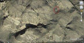
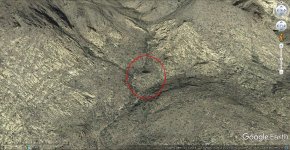
Here are two more Google Earth images of the strange surface feature, enclosed in ellipses. Even in wider-angle views it is very prominent, but could be easily missed by anyone walking below in the wash.

010.jpg

011.jpg
 

Holyground

Hero Member
May 17, 2014
579
828
Not in the can
Detector(s) used
Garrett AT GOLD, Garrett ATX
Primary Interest:
All Treasure Hunting
I remember it as if it were yesterday, hanging out on that cliff, about to lose my grip and plummet 1000 feet below to my certain death. Just then my partner, with complete disdain in his voice, asking me as calmly as he possibly could, "DID YOU FORGET TO CLICK ON TERRAIN AGAIN!?"

Yes, I sheepishly replied.
 

OP
OP
skyhawk1251

skyhawk1251

Sr. Member
Nov 9, 2018
311
669
Kingman, AZ
Detector(s) used
Fisher Gold Bug Pro
Primary Interest:
Prospecting
You're the perfect armchair explorer. Keep injecting a little humor, lest things get too serious here.
 

Top Member Reactions

Users who are viewing this thread

Top