Trails along the Salt River

EDN

Jr. Member
Apr 17, 2016
46
110
Gilbert, Arizona
Detector(s) used
Minelab Eureka Gold
Primary Interest:
All Treasure Hunting
Does anyone know about trails that went along the Salt River before the Dams were built?

I have read many stories describing a crossing where cottonwood canyon meets the salt. They would travel up to tortilla pass and other canyons heading south. I have read Waltz came down cotton wood canyon from hidden water to the salt, but could he and other come up the salt from the west? What about trails along the salt traveling east from Stewart Mountain Dam ( 33.566384°, -111.535617°) to the point the Cottonwood Canyon dumps into the Salt ( 33.565321°,-111.464715°)?

I seen on an old map of a ranch this should be under water now at around this location ( 33.564061°, -111.516465°). Trails.jpg
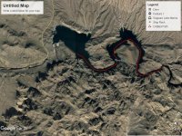
I attached a picture from Google Earth.

Thanks,

EDN
 

azdave35

Silver Member
Dec 19, 2008
3,606
8,104
i believe the old ranch would be stewart ranch...if you look on google earth you can still see the old road leading to the ranch
 

Last edited:

PotBelly Jim

Hero Member
Dec 8, 2017
898
2,986
Primary Interest:
Other
Does anyone know about trails that went along the Salt River before the Dams were built?

I have read many stories describing a crossing where cottonwood canyon meets the salt. They would travel up to tortilla pass and other canyons heading south. I have read Waltz came down cotton wood canyon from hidden water to the salt, but could he and other come up the salt from the west? What about trails along the salt traveling east from Stewart Mountain Dam ( 33.566384°, -111.535617°) to the point the Cottonwood Canyon dumps into the Salt ( 33.565321°,-111.464715°)?

I seen on an old map of a ranch this should be under water now at around this location ( 33.564061°, -111.516465°). View attachment 1699586

I attached a picture from Google Earth.

Thanks,

EDN

Good question, EDN. The answer is yes, Waltz could have come up the Salt from the west to the areas you described. While in times of high water this could be difficult, generally it would have been possible.

The question is really not if someone COULD travel on the river…it’s who would WANT to.

It was much more difficult to stay on the river. There was, and is, much easier terrain than the Salt River. So people generally stuck to the easier terrain, up out of the Salt River, crossing it or the Verde where easiest.

The need for water, when traversing that easier terrain, dictated a stop at Agua Escondido if on the north side of the Salt.

The Salt DID become impassible farther upriver at the lower and upper box canyons. These are the areas immediately above and below Horse Mesa Dam. The upper box is now almost completely underwater at Apache Lake. If you look at a terrain map prior to Apache Lake, that canyon was a real doozy. Jim Bark wrote about having to cut a trail down the cliff at Horse Mesa to get to his mines down there.
 

azdave35

Silver Member
Dec 19, 2008
3,606
8,104
Good question, EDN. The answer is yes, Waltz could have come up the Salt from the west to the areas you described. While in times of high water this could be difficult, generally it would have been possible.

The question is really not if someone COULD travel on the river…it’s who would WANT to.

It was much more difficult to stay on the river. There was, and is, much easier terrain than the Salt River. So people generally stuck to the easier terrain, up out of the Salt River, crossing it or the Verde where easiest.

The need for water, when traversing that easier terrain, dictated a stop at Agua Escondido if on the north side of the Salt.

The Salt DID become impassible farther upriver at the lower and upper box canyons. These are the areas immediately above and below Horse Mesa Dam. The upper box is now almost completely underwater at Apache Lake. If you look at a terrain map prior to Apache Lake, that canyon was a real doozy. Jim Bark wrote about having to cut a trail down the cliff at Horse Mesa to get to his mines down there.
even if you could get across at cottonwood canyon...the south side of the river is all cliffs from canyon lake to the east and bagley flat to the west
 

PotBelly Jim

Hero Member
Dec 8, 2017
898
2,986
Primary Interest:
Other
even if you could get across at cottonwood canyon...the south side of the river is all cliffs from canyon lake to the east and bagley flat to the west

Yup. Not my idea of a good time. It's the river bottom all the way, no guarantee you won't run into an impassible section...if you do, then it's back-track to find a place to get out...I've done literally every inch of the Salt, it's tough floating it even with all the dams...(EDIT: What I mean is, I couldn't imagine trying to walk the river bottom and trying to get through)

From the north, I think the last place you could cross over to the south back then was Fish Creek. If you didn't cross there, you were generally stuck on the north side until you got around the box canyon at Tonto Creek/Salt River junction (Roosevelt Dam now).
 

Last edited:

Gregory E. Davis

Sr. Member
Oct 22, 2013
331
997
Tempe, Arizona
Detector(s) used
eyeball it
Primary Interest:
All Treasure Hunting
Good evening Gentleman: I have been told that here was a place where one could cross the Salt River in the old days from north to south just down stream from where the Mormon Flat Dam is located today. From there one could work their way around the cliffs and then upriver to Tortilla Creek. Cordially, Gregory E. Davis
 

Matthew Roberts

Bronze Member
Apr 27, 2013
1,131
4,955
Paradise Valley, Arizona
Primary Interest:
All Treasure Hunting
Good evening Gentleman: I have been told that here was a place where one could cross the Salt River in the old days from north to south just down stream from where the Mormon Flat Dam is located today. From there one could work their way around the cliffs and then upriver to Tortilla Creek. Cordially, Gregory E. Davis

Hello Greg,

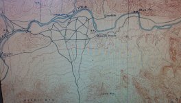
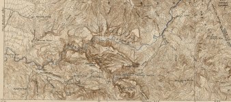
There were several good crossings of the Salt River. Where Cottonwood Canyon (Hidden Water) empties into the Salt was an excellent crossing in the days before the Dams were constructed. Jones Ford and the Limekiln were two fords used by sheep me in the late 1800's to get their sheep from the northern ranges to the Tonto Basin Pleasant Valley area. These two old maps show some of the crossings.

Best as always,

Matthew

Monroy ranch topo map.jpg

Before Canyon-Apache Lake 1912.jpg
 

Matthew Roberts

Bronze Member
Apr 27, 2013
1,131
4,955
Paradise Valley, Arizona
Primary Interest:
All Treasure Hunting
Good evening Gentleman: I have been told that here was a place where one could cross the Salt River in the old days from north to south just down stream from where the Mormon Flat Dam is located today. From there one could work their way around the cliffs and then upriver to Tortilla Creek. Cordially, Gregory E. Davis

Greg,

From an old Military map of the area the crossing near where Mormon Flat is today was known as the Rock Shallows. Mormon Flat was chosen as a dam site because of the narrowing of the canyon at that spot and the shallow rock base the dam was built on. Of course most all of these old fords or crossings were severely altered by the dams that were built and the releases of water from those dams.

Matthew
 

deducer

Bronze Member
Jan 7, 2014
2,278
4,352
Primary Interest:
Other
Good evening Gentleman: I have been told that here was a place where one could cross the Salt River in the old days from north to south just down stream from where the Mormon Flat Dam is located today. From there one could work their way around the cliffs and then upriver to Tortilla Creek. Cordially, Gregory E. Davis

I think that's the route that Waltz took, the most.

Where Tortilla Creek empties into the Salt is the area known as Mormon Flat and it's relatively easy to traverse when the creek bed isn't flooded. I've been over that terrain a few times.

Just past where the creek crosses the Apache trail is of course where Waltz caught Dick Holmes trailing him.
 

Top Member Reactions

Users who are viewing this thread

Top