Where are the heart carvings?

somehiker

Silver Member
May 1, 2007
4,365
6,426
Primary Interest:
All Treasure Hunting
Yer welcome.
Supposedly, the hill has mining claims on it and is posted and fenced off.
 

somehiker

Silver Member
May 1, 2007
4,365
6,426
Primary Interest:
All Treasure Hunting
Positive
See the photos and GE views on the other website for comparison.
 

deducer

Bronze Member
Jan 7, 2014
2,281
4,360
Primary Interest:
Other
Well, that trashes a number of assumptions that I had about the purpose Twin Buttes served to certain, interested parties. That these markings are now three miles, and slightly NNW inland would seem to mean that interested parties headed inland from the Buttes, rather than skirting the outside until reaching QC. Perhaps it was to avoid settlements on the plains around QC.

What's interesting is that these markings are next to an arroyo that empties into the Gila right where the Buttes are.

But from the markings, to where?
 

markmar

Silver Member
Oct 17, 2012
4,117
6,259
Primary Interest:
All Treasure Hunting
marius..tom was mistaken on that...they are not on south butte

Could be Dave. IMO that region has nothing to do with the stone maps. Maybe was a point of reference in someone's journey.
 

deducer

Bronze Member
Jan 7, 2014
2,281
4,360
Primary Interest:
Other
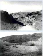
One of the oldest photos of the carvings that I could get my hands on:

TBcarvings.jpg

Where you can see a heart, an arrow in the shape of a "7" pointing to the heart. I think this picture is probably from Bob Ward.

I've reviewed my notes and it seems that there were two sites, according to Tracy Hawkins. This one, for which somehiker has given coordinates, and another, further south containing a horse, dagger, and a date.

Tracy says: I was shown the scrapings by a chap who had a claim and had sunk a shaft in the center of the heart where the arrow pointed in the early 60's. I have been back to them several times over the years and flew over them several times while looking for signs of old trails and stage routes.

He claims to have run into folks that were trying to date the ironwood trees growing in the path of the scrapings: The people I talked to ( Ernie and I ) were from Northern Az Univ. in Flagstaff. We ran into them on the second or third trip Ernie had made there so it was in the mid 60's. At that time they were taking samples of the ironwood trees growing through the scraping to ringdate. I heard later that some of them were 350 years old,

Hopefully Kraig Roberts will read this and chime in a bit about the carvings- he has some more information, I think.
 

deducer

Bronze Member
Jan 7, 2014
2,281
4,360
Primary Interest:
Other
More from Tracy on the other site:

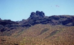
Anyone who has seen the carvings on the hillsides just north of the twin buttes would come to the conclusion that who ever made those maps had seen these carvings as they are very much alike,---horses head, dagger,hearts , heart with the arrow, 1847 etc.
I am not quilified to judge the age of the carvings--they were made by scraping the top soil fron the lighter colored dacite and are at least 200 feet high--the hearts ,that is. The other carvings are somewhat smaller. The brush that has grown up through and around them would indicate they are several hundred years old , with one exception--the number 1847--it apears to have been added at a later date. I base that on the differance in the construction ad the size of the brush.
These carvings can be seen from the air by following the river to the twin buttes and watching the north bank--they are within 1/4 miles of the river and are on both the eastern and western sides of the hills.


Also, another picture. This time of what seems to be two hearts.

Heart-2.JPG
 

somehiker

Silver Member
May 1, 2007
4,365
6,426
Primary Interest:
All Treasure Hunting
The two hearts are on the west side of the ridge, opposite the heart and seven on the eastern side, and the 3 leg "stick" horse is on the south end, as can be seen in the second B/W photo you posted above.
Way too much work for even a group of folks to do as a hoax, so could be related to what the stones were meant for. The Blythe Intaglios are another example of this kind of artifact, obviously meant to be seen from some distance by those who would understand what they meant.
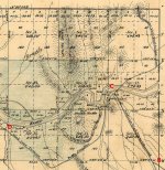
Here's a map from the 1850's or 60's.....prior to the construction of Cochran and the Coke ovens, or any "stage line"....which shows an existing mining/smelting operation where the Coke ovens were later constructed, as well as the "stone HOUSE" already standing on the rise well to the east of Cochran at the time the map was surveyed. I've crossed out and relocated the scrapings location to where it's a better match on this old map I think.

View attachment 1704213
 

deducer

Bronze Member
Jan 7, 2014
2,281
4,360
Primary Interest:
Other
deducer,

Do you have any evidence the large carvings ( Heart and others ) which appear on the hillsides were made prior to December 1965 ?

Best,

Matthew

Hi Matthew,

I have no hard evidence; only Tracy's assertion about finding an ironwood tree growing in the path of one of those scrapings, as well as bushes, et al.

And also the reasoning that to fabricate a hoax on that scale would have been a downright harebrained scheme as the terrain in that area is pretty rough. And to what extent? What profit? Just to have a little fun?

What do you think?

And why the date, 1965?
 

Last edited:

azdave35

Silver Member
Dec 19, 2008
3,606
8,104
Hi Matthew,

I have no hard evidence; only Tracy's assertion about finding an ironwood tree growing in the path of one of those scrapings, as well as bushes, et al.

And also the reasoning that to fabricate a hoax on that scale would have been a downright harebrained scheme as the terrain in that area is pretty rough. And to what extent? What profit? Just to have a little fun?

What do you think?

And why the date, 1965?


"And also the reasoning that to fabricate a hoax on that scale would have been a downright harebrained scheme as the terrain in that area is pretty rough. And to what extent? What profit? Just to have a little fun?"...deducer...you would be surprised...lol
 

Last edited by a moderator:

somehiker

Silver Member
May 1, 2007
4,365
6,426
Primary Interest:
All Treasure Hunting
I know-I know !
Barry Storm !
lol
 

Last edited:

Matthew Roberts

Bronze Member
Apr 27, 2013
1,131
4,955
Paradise Valley, Arizona
Primary Interest:
All Treasure Hunting
deducer, somehiker, azdave35,

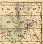
I took somehikers 1892 map and drew in BLUE the old Sonora Trail and where the crossing of the Gila was in the old days. This is from an old Military map from Calabasas or Tucson.

Also put a BLUE X in the general area where Tom Kollenborn believed there were carvings which may have been either Anglo, Spanish or Native American ? From one of Kollenborn's maps.

Matthew

1892 survey map Gila trail.jpg
 

Top Member Reactions

Users who are viewing this thread

Top