Don Peralta's 1864 Letter to Jacob Waltz

Idahodutch

Bronze Member
Sep 25, 2019
1,847
4,780
Idaho
Detector(s) used
Whites MXT
Gold Legend
Primary Interest:
Other
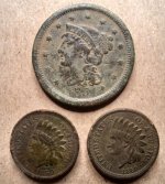
Any photos you care to share? Thanks in advance, and if you would rather not post them I understand completely and won't be offended.

:coffee2: :coffee: :coffee2:
Oro,
I wish I did, I would have liked to use more than GE for the Dutchman's Catches thread too. Had to barrow a couple from the net, for posting about Aylors Arch.
Young and dumb, Isn''t that what they say ???
Idaho Dutch
 

Idahodutch

Bronze Member
Sep 25, 2019
1,847
4,780
Idaho
Detector(s) used
Whites MXT
Gold Legend
Primary Interest:
Other
Oro,
I wish I did, I would have liked to use more than GE for the Dutchman's Catches thread too. Had to barrow a couple from the net, for posting about Aylors Arch.
Young and dumb, Isn''t that what they say ???
Idaho Dutch

Oro,
Most of my time in there, I was quite a bit younger. The small cameras they started to come out with , the kind you use once and toss. . . the pices are not very good, and I wasn't a photographer, so spend money on something that I didn't even know how to care for, into the supers, just wasn't something that I spent much time thinking about.

Also, I never would have believed that one day I would talk about search secrets on a public forum. . . .

Maybe, if there is a next time, I think I'll try to work something out :icon_thumleft:
That was a good question Oro.
Idaho Dutch
(edit; I just re-read this post and it sounds almost sarcastic. it was not meant that way. :angel3: )
 

Last edited:
OP
OP
skyhawk1251

skyhawk1251

Sr. Member
Nov 9, 2018
311
669
Kingman, AZ
Detector(s) used
Fisher Gold Bug Pro
Primary Interest:
Prospecting
Oro,
Most of my time in there, I was quite a bit younger. The small cameras they started to come out with , the kind you use once and toss. . . the pices are not very good, and I wasn't a photographer, so spend money on something that I didn't even know how to care for, into the supers, just wasn't something that I spent much time thinking about.

Also, I never would have believed that one day I would talk about search secrets on a public forum. . . .

Maybe, if there is a next time, I think I'll try to work something out :icon_thumleft:
That was a good question Oro.
Idaho Dutch
(edit; I just re-read this post and it sounds almost sarcastic. it was not meant that way. :angel3: )

Hope you don't die without revealing your search secrets to family members and trusted friends. One Dutchman is more than enough. I'm still thinking about Tom Kollenborn's passing, and all his life experience that has been lost. Fortunately, he left behind some maps and many newspaper articles that he wrote, but I'm wondering if he left directions to his secret Crystal Cave and other "mystic" locations. I think everyone who has secret locations and searches should leave them as a legacy to the next generation, and that way many mysteries will be solved.
 

Idahodutch

Bronze Member
Sep 25, 2019
1,847
4,780
Idaho
Detector(s) used
Whites MXT
Gold Legend
Primary Interest:
Other
Hope you don't die without revealing your search secrets to family members and trusted friends. One Dutchman is more than enough. I'm still thinking about Tom Kollenborn's passing, and all his life experience that has been lost. Fortunately, he left behind some maps and many newspaper articles that he wrote, but I'm wondering if he left directions to his secret Crystal Cave and other "mystic" locations. I think everyone who has secret locations and searches should leave them as a legacy to the next generation, and that way many mysteries will be solved.

Skyhawk,
I did a thread Dutchman's Caches, and spelled out quit a bit. I wasn't a forum guy, so it took longer than I thought. Pick a location clue, and most likely it fits that ravine. Even 4 Peaks as one is there.
I don't think today's hunters know the geography in there as well as the hunters a few decades ago. I thought for sure that everybody knew exactly where I was talking about, but apparently not. The interesting ravine I pointed out here, is the same ravine in Dutchman's Caches.
Idahodutch
 

Last edited:
OP
OP
skyhawk1251

skyhawk1251

Sr. Member
Nov 9, 2018
311
669
Kingman, AZ
Detector(s) used
Fisher Gold Bug Pro
Primary Interest:
Prospecting
Here are more Google Earth images of Idahodutch's ravine. It definitely looks like a place that has some interesting geology. Notice the extreme uplifting, shown in the close-ups. Uplifting is commonly associated with outcrops of mineral ore.

000.jpg

001.jpg

002.jpg
 

OP
OP
skyhawk1251

skyhawk1251

Sr. Member
Nov 9, 2018
311
669
Kingman, AZ
Detector(s) used
Fisher Gold Bug Pro
Primary Interest:
Prospecting
Let me steer this thread back to the words contained in the Ortiz Letter, so that later on I can start a new thread, which will begin with my personal interpretation of where the directions in the letter could lead. As I wrote earlier, the letter does not contain enough detailed information to lead anyone to a specific mine site, but can only point to a very general vicinity, if it does even that much. And, with the letter's vagueness in mind, that brings the question, "why was the letter written in the first place, and what good is it?" The answer to the last part of that question, in my opinion, is, "not much good at all," and that fact alone makes the validity of the letter doubtful. Regardless of all that, however, I'll take the letter at face value, as it is, and use it, along with topographical maps, to lead me somewhere in the Superstitions.

I can probably safely say that the general consensus of the forum is that the wording of the Ortiz Letter is as follows:

"... first go to tordis mountain, then south side go eastward until you find the first gorge on the south side from the west end follow the gorge until you find another trail which will lead you northwards over a lofty ridge then downwards past hidden needle to a long canyon and then east to a tributary canyon about 35-40 meters from the end after you find the mine destroy ..." 1864 Don Peralta

And, for comparison, here is Bicknell's wording, which he spruced-up just a bit for public consumption:

"... The mine lies within an imaginary circle, whose diameter is not more than 5 miles, and whose center is marked by the Weaver's Needle, which is about 2,500 feet higher, among a confusion of lesser peaks and mountain masses of basaltic rock. The first gorge on the south side from the west end of the range. They found a monumental trail which lead them northward past Sombrero Butte into a long canyon. Travel northward in the gorge and up over a lofty ridge, thence downward past the Needle into a canyon running north, and finally into a tributary canyon, very steep and rocky, and densely wooded with a continuous thicket of scrub oak."

For my purposes, I'll use only the Ortiz Letter to guide me, and go from there. For my new thread, I'll map my best-guess route.
 

Idahodutch

Bronze Member
Sep 25, 2019
1,847
4,780
Idaho
Detector(s) used
Whites MXT
Gold Legend
Primary Interest:
Other
Here are more Google Earth images of Idahodutch's ravine. It definitely looks like a place that has some interesting geology. Notice the extreme uplifting, shown in the close-ups. Uplifting is commonly associated with outcrops of mineral ore.

View attachment 1800909

View attachment 1800910

View attachment 1800911

Skyhawk,
In the German clues, one has Waltz calling the ravine, his uplift. Something like.... 3,000 meters from the springs he liked to frequent, to his uplift.
 

Al D

Bronze Member
Jul 23, 2011
2,066
3,524
Gold canyon AZ
Detector(s) used
DJI Air 2S
Primary Interest:
Cache Hunting
Weavers Needle
 

Attachments

  • 7B559709-54B8-4F66-827F-F8D5CD2F0F08.jpeg
    7B559709-54B8-4F66-827F-F8D5CD2F0F08.jpeg
    754.6 KB · Views: 73

Matthew Roberts

Bronze Member
Apr 27, 2013
1,131
4,955
Paradise Valley, Arizona
Primary Interest:
All Treasure Hunting
Idahodutch, alan m, somehiker,

You are right, but for the life of me I cant make out what that "uplifted area" is ?
Is it Black Top Mesa or north of Black Top?

Would someone mark the canyons and what the uplift is ?

Thanks!
 

gollum

Gold Member
Jan 2, 2006
6,729
7,594
Arizona Vagrant
Detector(s) used
Minelab SD2200D (Modded)/ Whites GMT 24k / Fisher FX-3 / Fisher Gold Bug II / Fisher Gemini / Schiebel MIMID / Falcon MD-20
Primary Interest:
All Treasure Hunting
Hey Kraig,

What you have labeled as Needle Canyon is La Barge Canyon. Your Weavers Needle is the little ridge just to the North of Blacktop. Blacktop is just out of the picture to the South.

Mike
 

gollum

Gold Member
Jan 2, 2006
6,729
7,594
Arizona Vagrant
Detector(s) used
Minelab SD2200D (Modded)/ Whites GMT 24k / Fisher FX-3 / Fisher Gold Bug II / Fisher Gemini / Schiebel MIMID / Falcon MD-20
Primary Interest:
All Treasure Hunting
Hey Kraig,<br><br>What you have labeled as Needle Canyon is La Barge Canyon. Your Weavers Needle is the little ridge just to the North of Blacktop. Blacktop is just out of the picture to the South.<br><br>

NorthofBT.jpg

Mike
 

Last edited:

Al D

Bronze Member
Jul 23, 2011
2,066
3,524
Gold canyon AZ
Detector(s) used
DJI Air 2S
Primary Interest:
Cache Hunting
Hope this helps
 

Attachments

  • BCD0F090-8699-4370-922B-69F87E07CD69.jpeg
    BCD0F090-8699-4370-922B-69F87E07CD69.jpeg
    745.8 KB · Views: 75

Matthew Roberts

Bronze Member
Apr 27, 2013
1,131
4,955
Paradise Valley, Arizona
Primary Interest:
All Treasure Hunting
Thanks gollum, alan m,

I never use Google Earth and just confuse myself when I try.

I just couldn't for some reason imagine Skyhawk's canyon as being LaBarge, to me it looked like Needle, with Boulder canyon off on the left.
I need to stick to the ground !
 

Idahodutch

Bronze Member
Sep 25, 2019
1,847
4,780
Idaho
Detector(s) used
Whites MXT
Gold Legend
Primary Interest:
Other
Hey Kraig,

What you have labeled as Needle Canyon is La Barge Canyon. Your Weavers Needle is the little ridge just to the North of Blacktop. Blacktop is just out of the picture to the South.

Mike
Gollum,
With all due respect, Mathew correctly labeled Needle canyon, it was only the uplift that was mislabeled as Weavers Needle. However, you are spot on as far as north end of Blacktop Mesa, for that uplift (south ridge of the ravine). It is still considered to be part of Blacktop Mesa though.
The part of Blacktop Mesa that most think of, you correctly state as just out of view to the south.

Mathew,
I have been on the road today, and don't have my computer with, or I would get something together that would be very easy to discern what is what. I've gotten some practice lately.

Sometimes, looking at Google earth can mess with your eyes. All the canyons, ridges and shadows sometimes seem to reverse polarity in my mind and can be difficult to see what are the canyons and what are the ridges. Changing viewing altitude usually gets rid of the effect.
I guess sort of an optical illusion.

You guys are both heavy hitters in my book,
Idaho Dutch
 

Top Member Reactions

Users who are viewing this thread

Top