The Ambiguous Ortiz Letter

skyhawk1251

Sr. Member
Nov 9, 2018
311
669
Kingman, AZ
Detector(s) used
Fisher Gold Bug Pro
Primary Interest:
Prospecting
This discussion could end up being a very lengthy and convoluted thread, with a lot of "forks" as it moves along, so I'll probably add to it in parts. This will be "Part One," and I'll title it "The Trailhead."

I describe the Ortiz Letter as "ambiguous" because its wording is so vague that it can be taken to have more than one meaning. It does not provide complete and accurate directions to find a mine site, and thus, fails to fulfill its intended purpose. I would guess that it was written by a prankster sometime after Bicknell's newspaper article was published. It's similar enough to Bicknell's article, and adds some tantalizing details (probably fictional), so I'll use it alone, as a guide, to warrant selling all my worldly belongings, using the money to pack my burros, and spend the rest of my life searching for the Lost Dutchman Mine. The Ortiz Letter reads as follows:

"... first go to tordis mountain, then south side go eastward until you find the first gorge on the south side from the west end follow the gorge until you find another trail which will lead you northwards over a lofty ridge then downwards past hidden needle to a long canyon and then east to a tributary canyon about 35-40 meters from the end after you find the mine destroy ..."

For comparison, Bicknell's 1895 newspaper article uses this wording:

"... The mine lies within an imaginary circle, whose diameter is not more than 5 miles, and whose center is marked by the Weaver's Needle, which is about 2,500 feet higher, among a confusion of lesser peaks and mountain masses of basaltic rock. The first gorge on the south side from the west end of the range. They found a monumental trail which lead them northward past Sombrero Butte into a long canyon. Travel northward in the gorge and up over a lofty ridge, thence downward past the Needle into a canyon running north, and finally into a tributary canyon, very steep and rocky, and densely wooded with a continuous thicket of scrub oak."

Notice that the word "lofty" is used in both sources. It is more of a journalist's word than what would be expected from a Mexican man struggling to write in the English language. So, that fact alone gives me ample proof that most of the Ortiz Letter is "borrowed" from Bicknell's article.

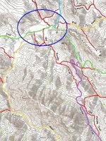
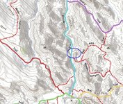
With only the Ortiz Letter in mind, however, my route to the vicinity of the mine begins at "the first gorge on the south side from the west end," which is the gorge where West Boulder Trail begins. I see Peralta Trail beginning at the second gorge on the south side from the west end. I also like beginning at West Boulder Trail, rather than Peralta Trail, because when old man Ruth asked if there was a pinnacle nearby he was taken up West Boulder Trail to Willow Spring by the two cowboys. Ruth seem to be fixated on Weaver's Needle as a vital landmark, just as it is in the Ortiz Letter (hidden needle).

My route follows West Boulder Trail only part way, then makes a detour that can be justified by one essential reason. The reason for the detour is to gain elevation, and to put Weaver's Needle in sight. It's the landmark that will be used as a guidepost -- a vital reference point. Part Two will continue with "... another trail which will lead you northwards over a lofty ridge ..."

X.jpg

Y.jpg

Z.jpg
 

Idahodutch

Bronze Member
Sep 25, 2019
1,847
4,780
Idaho
Detector(s) used
Whites MXT
Gold Legend
Primary Interest:
Other
Skyhawk,
I've been of the thought, that going on into West Boulder from the end of that 1st gorge, and then on to Boulder, was perhaps the route for wagons (visualizing large Peralta party), and foot or mule travel was perhaps cutting over to drop down East Boulder. Peralta canyon is not good for wagons.
There is something not adding up though at first glance. Why then the name for Peralta Canyon?
To me, the directions using Weavers Needle as a landmark seems like Peralta Canyon would provide a less complicated route, unless you needed to take in wagons.
LaBarge is a nother to get wagons to Marsh Valley, but not by those directions.

For Ruth, I was under the impression, he wanted to have his base camp at willow spring, was why the cowboys took him there. And not because of Weavers Needle? Who knows, maybe it for both.
Idahodutch
 

OP
OP
skyhawk1251

skyhawk1251

Sr. Member
Nov 9, 2018
311
669
Kingman, AZ
Detector(s) used
Fisher Gold Bug Pro
Primary Interest:
Prospecting
"The Ambiguous Ortiz Letter -- Part Two"

"... first go to tordis mountain, then south side go eastward until you find the first gorge on the south side from the west end follow the gorge until you find another trail which will lead you northwards over a lofty ridge then downwards past hidden needle to a long canyon and then east to a tributary canyon about 35-40 meters from the end after you find the mine destroy ..."

My route continues with "... another trail which will lead you northwards over a lofty ridge ..."

I understand this portion of the Ortiz Letter as meaning: leave the trail that was first taken when the gorge was entered, and find another trail that will lead northwards over a lofty ridge." "Another trail" does not immediately head northwards, but LEADS, eventually, northwards over a lofty ridge. The lofty ridge is east of West Boulder Trail, and must be crossed over before the northwards trail is reached. To accomplish the crossover, a trail following a path such as Dacite Mesa Trail must be followed. At the top of the lofty ridge, Weaver's Needle will be visible to guide the way. There might be easier ways to cross the lofty ridge, other than Dacite Mesa Trail, but the prime objective is to put Weaver's Needle into view, by crossing the lofty ridge, and then connect to Peralta Trail, just west of Weaver's Needle. This crossover might seem to be a needless detour from West Boulder Trail, but I'm following the Ortiz Letter to endless riches, so this is the way I must go. Now that I'm on Peralta Trail, I'll continue northwards past hidden/Weaver's Needle to a long canyon. Part Three will follow soon ...

001.jpg
 

OP
OP
skyhawk1251

skyhawk1251

Sr. Member
Nov 9, 2018
311
669
Kingman, AZ
Detector(s) used
Fisher Gold Bug Pro
Primary Interest:
Prospecting
Skyhawk,
I've been of the thought, that going on into West Boulder from the end of that 1st gorge, and then on to Boulder, was perhaps the route for wagons (visualizing large Peralta party), and foot or mule travel was perhaps cutting over to drop down East Boulder. Peralta canyon is not good for wagons.
There is something not adding up though at first glance. Why then the name for Peralta Canyon?
To me, the directions using Weavers Needle as a landmark seems like Peralta Canyon would provide a less complicated route, unless you needed to take in wagons.
LaBarge is a nother to get wagons to Marsh Valley, but not by those directions.

For Ruth, I was under the impression, he wanted to have his base camp at willow spring, was why the cowboys took him there. And not because of Weavers Needle? Who knows, maybe it for both.
Idahodutch

What I'm trying to do with this thread is to find a route through the Superstition Mountains, guided only by the Ortiz Letter, and with some help from topographical maps. Knowing about the Ruth saga is useful because it verifies that West Boulder Canyon/Trail is a favored passage into the mountains, suitable for horses and pack animals. When reading this thread, try to imagine that you know little to nothing about the Superstition Mountains and someone hands you the Ortiz Letter, and nothing else. Where would it lead you? All you know is that you want your route to match the descriptions and topography given in the letter. You have the letter in your hand, and you're on your own.

Always keep in mind that the route I'm trying to follow here is NOT the route I would have expected the Mexican miners to have taken to their main camp in Marsh Valley, nor is it the route I would have expected Jacob Waltz to have taken to his mine. This route, described in the Ortiz Letter and Bicknell's account, is very unusual, and seems to have nothing in common with other routes described in historic documents. Also, please remember that modern-day trails shown on topograpical maps don't always correspond to the ancient trails. Topography has not changed, however, so you can be assured that the easiest ways through the mountains are still the easiest ways today.
 

Last edited:
OP
OP
skyhawk1251

skyhawk1251

Sr. Member
Nov 9, 2018
311
669
Kingman, AZ
Detector(s) used
Fisher Gold Bug Pro
Primary Interest:
Prospecting
"The Ambiguous Ortiz Letter -- Part Three"

"... first go to tordis mountain, then south side go eastward until you find the first gorge on the south side from the west end follow the gorge until you find another trail which will lead you northwards over a lofty ridge then downwards past hidden needle to a long canyon and then east to a tributary canyon about 35-40 meters from the end after you find the mine destroy ..."

My route continues with "... downwards past hidden needle to a long canyon ..."

I've descended from the lofty ridge, and am heading northwards along Peralta Trail. I pass hidden/Weaver's Needle, which is east of the trail. I'm next looking for a long canyon, and the Ortiz Letter provides no details about the "long canyon." I continue along Peralta/Old Peralta Trail until I come to the trail's end. I find myself in an extended piece of level terrain (see the inserted image, blue ellipse). It looks like a "long canyon" to me. Ahead of me, high slopes form a solid wall. It's time now to head east and find "a tributary canyon." Here is where the letter's ambiguity really takes its toll. Part Four will follow soon ...

002.jpg
 

Idahodutch

Bronze Member
Sep 25, 2019
1,847
4,780
Idaho
Detector(s) used
Whites MXT
Gold Legend
Primary Interest:
Other
"The Ambiguous Ortiz Letter -- Part Three"

"... first go to tordis mountain, then south side go eastward until you find the first gorge on the south side from the west end follow the gorge until you find another trail which will lead you northwards over a lofty ridge then downwards past hidden needle to a long canyon and then east to a tributary canyon about 35-40 meters from the end after you find the mine destroy ..."

My route continues with "... downwards past hidden needle to a long canyon ..."

I've descended from the lofty ridge, and am heading northwards along Peralta Trail. I pass hidden/Weaver's Needle, which is east of the trail. I'm next looking for a long canyon, and the Ortiz Letter provides no details about the "long canyon." I continue along Peralta/Old Peralta Trail until I come to the trail's end. I find myself in an extended piece of level terrain (see the inserted image, blue ellipse). It looks like a "long canyon" to me. Ahead of me, high slopes form a solid wall. It's time now to head east and find "a tributary canyon." Here is where the letter's ambiguity really takes its toll. Part Four will follow soon ...

View attachment 1802662

Skyhawk,
I'm not sure, so I go ahead and ask the question - Are you wanting to lay out everything, and then have discussion? or were you wanting discussion along the way?
Either way is good. Just wondering :icon_scratch:
Idahodutch
 

OP
OP
skyhawk1251

skyhawk1251

Sr. Member
Nov 9, 2018
311
669
Kingman, AZ
Detector(s) used
Fisher Gold Bug Pro
Primary Interest:
Prospecting
Skyhawk,
I'm not sure, so I go ahead and ask the question - Are you wanting to lay out everything, and then have discussion? or were you wanting discussion along the way?
Either way is good. Just wondering :icon_scratch:
Idahodutch

Probably best to have discussion after I've posted all parts. Looks like Part Four will be the final part, and the conclusion of what is described in the Ortiz Letter, plus in Part Four I'll provide more information that is not contained in the Ortiz Letter, but that might generate more diverging opinions than what was covered in the previous parts.
 

OP
OP
skyhawk1251

skyhawk1251

Sr. Member
Nov 9, 2018
311
669
Kingman, AZ
Detector(s) used
Fisher Gold Bug Pro
Primary Interest:
Prospecting
"The Ambiguous Ortiz Letter -- Part Four"

"... first go to tordis mountain, then south side go eastward until you find the first gorge on the south side from the west end follow the gorge until you find another trail which will lead you northwards over a lofty ridge then downwards past hidden needle to a long canyon and then east to a tributary canyon about 35-40 meters from the end after you find the mine destroy ..."

My route continues with "... to a long canyon and then east to a tributary canyon about 35-40 meters from the end ..."

... I find myself in an extended piece of level terrain. Wandering about, doubt begins to set in. Is it just the ambiguity of the Ortiz Letter that's confusing me, or is my brain being fried by the desert heat? My first thought was that this place could be the "long canyon" referred to in the letter, but there seems to be too many options for what could be "a tributary canyon." Is my quest at an end? Will I be another victim of "The Curse of the Dutchman's Gold?" No way. I can't give up.

The topographic map might provide an answer. I continue northeastwards to where the relatively level terrain ends, and there it is -- a really long canyon. Boulder Trail, marked on the map, follows the canyon northward. By heading north on the trail, I see that there is a tributary canyon branching off to the east, not far ahead. It's clearly shown on the topographic map. The Ortiz Letter doesn't give me any clues if this is the tributary canyon that leads to endless riches, but I'll need to explore it very thoroughly. The letter's words "... about 35-40 meters from the end ..." are puzzling. The only definite "end" I can think of at the moment is where the tributary canyon opens at the "long canyon." It looks like this is as far as the Ortiz Letter can take me for now. I'll need to set up camp, and give this tributary canyon very close scrutiny. I make myself as comfortable as possible, pull off my backpack, and search inside for my notes, made previously. On a copy of the topographic map I find, among other things, my present location circled, and the scrawled words, "Idaho Dutch's Ravine." Then something else comes to mind, and inserted into the pages of my notebook I find the Bark-Ely Map. It shows a route to a mine that looks very much like the route I followed to this ravine, the Bark-Ely Map's route passing to the west of Weaver's Needle, then connecting to a long canyon, with a mine located a short way east into a tributary canyon. Maybe that white-bearded, old man I bought drinks for at the bar in Phoenix, and who then handed me the Ortiz Letter, while saying, "there's enough gold to make twenty men millionaires," wasn't leading me on after all. The end, or maybe not ...

Hope everyone enjoyed reading this. Let the discussion begin.

C.jpg

D.jpg

E.jpg
 

Attachments

  • A.jpg
    A.jpg
    117.4 KB · Views: 125
  • B.jpg
    B.jpg
    173.6 KB · Views: 119

Idahodutch

Bronze Member
Sep 25, 2019
1,847
4,780
Idaho
Detector(s) used
Whites MXT
Gold Legend
Primary Interest:
Other
Skyhawk,
I was just reading along . . . then busted out laughing 😂
I have to admit, for some reason I do like the story.
You definitely caught me of guard :thumbsup:

Idahodutch
 

Idahodutch

Bronze Member
Sep 25, 2019
1,847
4,780
Idaho
Detector(s) used
Whites MXT
Gold Legend
Primary Interest:
Other
"The Ambiguous Ortiz Letter -- Part Three"

"... first go to tordis mountain, then south side go eastward until you find the first gorge on the south side from the west end follow the gorge until you find another trail which will lead you northwards over a lofty ridge then downwards past hidden needle to a long canyon and then east to a tributary canyon about 35-40 meters from the end after you find the mine destroy ..."

My route continues with "... downwards past hidden needle to a long canyon ..."

I've descended from the lofty ridge, and am heading northwards along Peralta Trail. I pass hidden/Weaver's Needle, which is east of the trail. I'm next looking for a long canyon, and the Ortiz Letter provides no details about the "long canyon." I continue along Peralta/Old Peralta Trail until I come to the trail's end. I find myself in an extended piece of level terrain (see the inserted image, blue ellipse). It looks like a "long canyon" to me. Ahead of me, high slopes form a solid wall. It's time now to head east and find "a tributary canyon." Here is where the letter's ambiguity really takes its toll. Part Four will follow soon ...

View attachment 1802662

Skyhawk,
The Old Peralta Trail; I think this was the first time seeing it laid out. I didn't know it went all the way down to the flats in lower part of West Boulder. I guess I didn't realize that East Boulder Canyon actually dies out up top, at the Old Peralta Trail.
It must have been all the sweat in the guys eyes that prevented him from seeing it as walked past it. I've had that sweat in the eye thing, and . . . it can be hazardous :0
Idahodutch
 

Last edited:
OP
OP
skyhawk1251

skyhawk1251

Sr. Member
Nov 9, 2018
311
669
Kingman, AZ
Detector(s) used
Fisher Gold Bug Pro
Primary Interest:
Prospecting
Skyhawk,
The Old Peralta Trail; I think this was the first time seeing it laid out. I didn't know it went all the way down to the flats in lower part of West Boulder. I guess I didn't realize that East Boulder Canyon actually dies out up top, at the Old Peralta Trail.
It must have been all the sweat in the guys eyes that prevented him from seeing it as walked past it. I've had that sweat in the eye thing, and . . . it can be hazardous :0
Idahodutch

I couldn't resist adding some suspense to this thread, and it's not meant to be a fictional tale, but a serious effort to use the Ortiz Letter as a guide, just as it is, for a path through the mountains to wherever it might lead. When I began the thread, I didn't know where the route would end. It was a complete surprise that your favored ravine would be a possible end for the route. There could be other possibilities farther up the "long canyon." I chose the first, and nearest, possible destination to end the thread, at least for now. Just before posting Part Four, I realized that the path through the mountains looked familiar, and that's when I compared my route to the Bark-Ely map.

By the way, I think the word "rincon" might be an accurate description for the flats. A rincon is a small, secluded valley surrounded by mountains.
 

Last edited:

Idahodutch

Bronze Member
Sep 25, 2019
1,847
4,780
Idaho
Detector(s) used
Whites MXT
Gold Legend
Primary Interest:
Other
I couldn't resist adding some suspense to this thread, and it's not meant to be a fictional tale, but a serious effort to use the Ortiz Letter as a guide, just as it is, for a path through the mountains to wherever it might lead. When I began the thread, I didn't know where the route would end. It was a complete surprise that your favored ravine would be a possible end for the route. There could be other possibilities farther up the "long canyon." I chose the first, and nearest, possible destination to end the thread, at least for now. Just before posting Part Four, I realized that the path through the mountains looked familiar, and that's when I compared my route to the Bark-Ely map.

By the way, I think the word "rincon" might be an accurate description for the flats. A rincon is a small, secluded valley surrounded by mountains.

When I first started, Bicknell's imaginary 5 mile circle, was a good place to start. And really, only needed to look at the upper 35% or so, if applying other clues. Red hills cuts off another chunk. I thought how long could it take, shouldn't take too long to get through that area, and then move elsewhere if it was scratched off the list. Then found that looking at some of the clues a little differently, that 2 more possible areas showed up, and they were not in the beaten to death "hot area". I chose to scratch those off first, which I did and then have been stuck in this area since. Haven't been able to scratch it off.
Maybe someone will be able to, but don't know :dontknow:
Idahodutch
 

Idahodutch

Bronze Member
Sep 25, 2019
1,847
4,780
Idaho
Detector(s) used
Whites MXT
Gold Legend
Primary Interest:
Other
When I first started, Bicknell's imaginary 5 mile circle, was a good place to start. And really, only needed to look at the upper 35% or so, if applying other clues. Red hills cuts off another chunk. I thought how long could it take, shouldn't take too long to get through that area, and then move elsewhere if it was scratched off the list. Then found that looking at some of the clues a little differently, that 2 more possible areas showed up, and they were not in the beaten to death "hot area". I chose to scratch those off first, which I did and then have been stuck in this area since. Haven't been able to scratch it off.
Maybe someone will be able to, but don't know :dontknow:
Idahodutch

When I was there in '08 and saw what I'm pretty certain, was a claim marker, I thought about it, and really, that doesn't scratch it off, but perhaps is revealing of some hidden (or undisclosed) history of the LDM.

I don't know, but I haven't been able to shake it. . . I mean the whole thing . . .
Idahodutch
 

Top Member Reactions

Users who are viewing this thread

Top