Clay Worst search area

Cubfan64

Silver Member
Feb 13, 2006
2,986
2,789
New Hampshire - USA
Detector(s) used
Fisher CZ21, Teknetics T2 & Minelab Sovereign GT
Primary Interest:
All Treasure Hunting
This informational story goes out to Clay Worst first and Apachegold for asking because I’m done with my research on the LDM and moving on to another treasure. Good luck on the venture!!

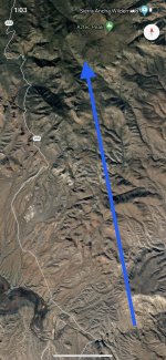
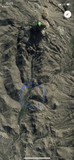
A descendant, nephew, of Jacob Weiser discovered a lost journal in which Weiser states that Carlos Peralta’s family found a decipher stone map at the bottom of the superstitious mountains which they transcribed into a journal. He used this map and knowledge of the whereabouts of the lost mine to strike a partnership deal. Beale by default is probably the creator of the stone to include that the stones carry information pertaining to Virginia. The southern Chiricahua Indians used to approach the mine from the east at the high point of the canyon. From there you could spot the changing face of the canyon which the sun changes throughout the day. The face has to large circular shaded areas that look like two eyes and a triangular looking nose. The facial clue was located at the top of the decipher map that Waltz gave Julia Roberts. The mine is so hidden that even if you find this place you might miss it if you don’t follow the clues. Waltz bought a property on the north side of the salt river near a crossing that Beale used to bring down the gold to Virginia. His property was located in the same exact location as described on the decipher map and from there according to the map he was suppose to go north. The only thing that was north of him was the rock horse canyon image found on the map. The rock horse canyon consists of a horse’s neck and head made out of many large broken rocks. Waltz would sneak out towards the mine which laid to the northeast without no one knowing. He would hide his gold in his farm and in the superstitious mountains so nobody would find his secret mine. From there he could go to Phoenix through the mountains to sell gold or go south towards New Mexico to include east or northeast. What a guy!!!!! From the top of the mine you could see the needle towards the southwest and the four points that became one to include part of the military trail. Everything Waltz said was true he would go north and jumped two Indian trails until he got the one that lead to the rock horse canyon. Three mile before the canyon the trail would bend passing through a cow farm which is still there with no cows!! About three quarters of a mile before the canyon the trail would split in two taking the left hand trail leading into an Indian outlook post which was located below the top portion of a small ridge mountain saddle. This place is located in the Sierra mountains and not in the superstitious mountains. Directly to the west above the Indian lookout in the highest Sierra ridge, there used to be a fort. The only thing there now is some structure stones and all the trails plus their lookouts. The Indian lookout sits on a small cliff which has rocks on both sides and in the center is a circular turnabout with another pile of rocks in the center. Waltz call this Indian ruins and in the very front still lies the old cottonwood stand. This stand is just like a deer stand where he would stay for a day to spy on the mine because no one could see him. The next day he would go down the hill towards the southeast curving towards the north passing over the gravel bar right by Tewksbury spring to make sure no one was camping near by. He then proceeded towards the armor coral spring located west of the three red hills which are not very red anymore. He spent most of the day at the spring spying in all directions to make sure no one was coming. At night fall he would take the old Indian trail that leads to the top of the canyon . He would then spy on the canyon and rat hole from across the canyon opposite of the mine to make sure nobody was around. The mine sits in a crevice on the northwest canyon wall unable to be seen from above or below. You must locate the entrance to the top ledge and work your way around an extension where you could look up and see it. Waltz was not lying about the clues he mentioned and the rest is history! This is the area that you can claim as your own since you don’t have one. I could sow you the satellite images, but that would spoil the hunt and the excitement.

The same applies to treasure hunter John Cruise Wilkins who’s been looking for Oliver Levasseur’s treasure in a place that he will never find it even if he has his heart set on it. I can give him the location of the treasure if he asks for it!! For free !!!! No finders fee unless he decides to give me some? An offer no treasure hunter should refuse, so can some please, if you know John let him know that the offer is on the table and waiting for him right now. If he refuses, well then in that case I’m sure someone else will be willing to take the offer.

Taking moderator's advice from a few days ago, but my head is about to explode :)
 

Ramiro valdez

Full Member
Aug 26, 2020
182
103
San Antonio, Texas
Primary Interest:
All Treasure Hunting
Waltz would go north towards the rock horse canyon

file:///var/mobile/Library/SMS/Attachments/66/06/C515811E-6E5B-440B-BB0C-35C080D8F1C5/IMG_0977.jpg
 

Attachments

  • FF3BC83C-4488-4D5B-8BEA-C52AC0ED987C.jpeg
    FF3BC83C-4488-4D5B-8BEA-C52AC0ED987C.jpeg
    311.4 KB · Views: 156

Ramiro valdez

Full Member
Aug 26, 2020
182
103
San Antonio, Texas
Primary Interest:
All Treasure Hunting
From the bottom towards the top in order

1 the fort on the left and the cow farm on the right ( first two circles )

2 the next circle is the top of the saddle Indian outlook post with the cotton wood stand

3 the top circle to the left is the gold mine’s canyon

4 the other two circles are where the springs are located


This all part of the Sierra Ancha mountains


E19CBE82-9AB5-46C5-9D1B-E61FCD40A4D8.jpeg
 

Last edited:

Ramiro valdez

Full Member
Aug 26, 2020
182
103
San Antonio, Texas
Primary Interest:
All Treasure Hunting
lot of times people get deceived by what was or is? If you study simple penmanship you can realize that Julia Thomas wrote and drew on the map that Waltz gave her. People from the area of Phoenix were right by saying that the map didn’t make sense. So she went some where else where people didn’t know and sold more maps to those with no knowledge of the monumental features in the superstitious mountains. A cipher map is hard to read, you must know the area, your direction of movement, and the symbolic meaning of the icons or symbols. You can’t go out there and just find the treasure, unless someone points it out to you. This photo below will show you what the map use to look like. 37AA56C8-FAE9-42F4-9A95-CA6606B2B4BF.jpeg 37AA56C8-FAE9-42F4-9A95-CA6606B2B4BF.jpeg
 

Ramiro valdez

Full Member
Aug 26, 2020
182
103
San Antonio, Texas
Primary Interest:
All Treasure Hunting
The cipher map was just about the area that surrounded the rock horse. An old Templar cipher method was to use monumental structures, mountain ridge lines and natural water drain run offs that mark the surrounding environment. This map had nothing to do with the superstitious mountains. I’m enjoying the laugh with all those who are laughing that had a hunch about this situation. The actual Lue treasure map uses two natural water drain runoff to mark its immediate area. That all I’m goi g to say about that right now because I gave the location away to a treasure hunting company for free!!!!! I’m just waiting on them, hope they follow through so I could explain unlocking the Lue map window. I think Beale, who created the cipher map is laughing out loud also! I might as well include Oliver Levasseur since he has been laughing for over 300 years. I’m not saying that there isn’t any hidden gold or big amounts of gold in the superstitious mountains because that’s where a pirate would have gone to hide stolen treasure belonging to someone else. I would no discredit anybody who says there is gold in the rugged mountains especially mr. Blindbowman or The Buzz unless you prove them wrong. All I’m saying is that the Dutch Lost Gold Mine is towards the east Sierra Ancha mountains.
 

Ramiro valdez

Full Member
Aug 26, 2020
182
103
San Antonio, Texas
Primary Interest:
All Treasure Hunting
Let’s clear some of the smoke

In 1880 two soldier found gold near an old mine. One of the managers, named Mason 8, from the silver king mine made a deal with the two soldiers. As associate prospectors representing Mason 8 they went back into the mountains to find and mark the mine as proof of claim as was required by law then. Mason 8 had a brother named Charles Mason part owner to the Silver King Mine. The two soldiers did as they were instructed before they were found dead. They actually found one of several Peralta’s discovered gold mines near weaver’s needle. It’s the first one from the needle heading north. The soldiers mark the mine on hard rock surface with an 8, but Mason never found it. The old mine they found was not the Dutchman’s Lost Gold Mine. Someone had taken gold from the LDM and transferred it to Peralta’s old gold mine for storage. The inscription of the number 8 is still there.


4902BED6-9F85-437A-823A-E9D7FE41132D.jpeg 2D3CF206-8CDB-4408-97DE-20340FCA3968.jpeg
 

Ramiro valdez

Full Member
Aug 26, 2020
182
103
San Antonio, Texas
Primary Interest:
All Treasure Hunting
First question? Does anyone know if this spring has a name?

Second question? Does anyone know how far this spring is from the needle?

Third question? Does anyone know maps that have used the three pines as a clue?

Forth question? Are these three pines located north of the needle?

I’ll give you some clues ( near, Twin Buttes Rd, west, north tank, plow beam tank )


What amazes me, is how someone can use these three pines from over 90 miles in a direct angle to the needle just to define the location of two gold mines near weaver’s needle.

87272F6C-2569-4552-B866-4E7ECAFCC68C.jpg
 

Ramiro valdez

Full Member
Aug 26, 2020
182
103
San Antonio, Texas
Primary Interest:
All Treasure Hunting
I’m not Eldo, Ramiro is truly my name, I find that using another made up name takes away from someone original character. Eldo and I , must have very similar skills to be compared. Some have already found some of these gold mines, but the point is to define old map methods that creators used in directing others to find them. Methods that can be helpful to those who may not know as much as those who are familiar with the area.
 

Cubfan64

Silver Member
Feb 13, 2006
2,986
2,789
New Hampshire - USA
Detector(s) used
Fisher CZ21, Teknetics T2 & Minelab Sovereign GT
Primary Interest:
All Treasure Hunting
Let’s clear some of the smoke

In 1880 two soldier found gold near an old mine. One of the managers, named Mason 8, from the silver king mine made a deal with the two soldiers. As associate prospectors representing Mason 8 they went back into the mountains to find and mark the mine as proof of claim as was required by law then. Mason 8 had a brother named Charles Mason part owner to the Silver King Mine. The two soldiers did as they were instructed before they were found dead. They actually found one of several Peralta’s discovered gold mines near weaver’s needle. It’s the first one from the needle heading north. The soldiers mark the mine on hard rock surface with an 8, but Mason never found it. The old mine they found was not the Dutchman’s Lost Gold Mine. Someone had taken gold from the LDM and transferred it to Peralta’s old gold mine for storage. The inscription of the number 8 is still there.


View attachment 1914586 View attachment 1914587

Mason 8? You mean Aaron Mason right? What does the 8 have to do with anything? And do you have a photo of the "8" inscription?
 

gollum

Gold Member
Jan 2, 2006
6,729
7,596
Arizona Vagrant
Detector(s) used
Minelab SD2200D (Modded)/ Whites GMT 24k / Fisher FX-3 / Fisher Gold Bug II / Fisher Gemini / Schiebel MIMID / Falcon MD-20
Primary Interest:
All Treasure Hunting
Mason 8? You mean Aaron Mason right? What does the 8 have to do with anything? And do you have a photo of the "8" inscription?

I bet I know what he's talking about:

18thplace.jpg

......and supposedly its "18" and not "8". LOL

Mike
 

Ramiro valdez

Full Member
Aug 26, 2020
182
103
San Antonio, Texas
Primary Interest:
All Treasure Hunting
Someone once asked Jacob Waltz, where in this country can I find a good starting point in finding the mine. He said he could go to the board house and back in a day, cause he has done it before. Some believe that he was talking about the mine being that far from the board house. But he was only trying to answer the gentleman’s question on the starting point which in fact was his farm. The answer to the question has always been the section of the salt river that lays east to west as stated on the stone map that Julia got from him before she wrote all over it. Many believe that he sealed the mine’s entrance when he was talking about the entrance to the ledge that leads to the mine. The entrance to the mine can be accessed through the top of the canyon where a large circular funnel shape rock entry will lead you to a ledge entry point that was covered by Waltz. The ledge will lead you to the mine’s immediate entry point. So you see, there is three entry points that one can talk about and the rock horse found towards the north in the Sierra mountains has all the answers.
 

Ramiro valdez

Full Member
Aug 26, 2020
182
103
San Antonio, Texas
Primary Interest:
All Treasure Hunting
Let me say this one more time because it’s funny! If you were to ask Waltz about a starting point he would say he went to the store and came back the same day? What is the starting point? He probably was laughing and the individual took it as a joke! Lol! Because he always started from the farm? But he was not joking according to the stone map, the he gave Julia, you should locate the section of the salt river which was right in front of his farm from where the map would direct you to the north to find the rock horse an area of 4 by 5 miles and not 40 by 50 mile area. I’m not laughing at those who didn’t because it’s a hard one to get if you don’t have the map, lm just laughing cause it’s a good joke that carries truth! Waltz was probably also a funny guy! You got to laugh at that if you have a sense of humor.

;
 

Ramiro valdez

Full Member
Aug 26, 2020
182
103
San Antonio, Texas
Primary Interest:
All Treasure Hunting
Here is how you will see the rock horse on the satellite

FD7010DD-76CA-4426-8DE7-898E2BFC10D7.jpg FD7010DD-76CA-4426-8DE7-898E2BFC10D7.jpg

And this the eye view when your approaching the rock horse from the southeast which is the way the treasure hunters approached it. This one is for those who are having trouble finding the rock horse.

48A902FD-FB93-4691-AAFA-4C60B1D994D0.jpg

When you find the rock horse, then you can use Jacob Waltz’s treasure map which he gave Julia Thomas because the map was drawn from the southeast looking towards the northwest.


Here is a thought! Think about Beale’s treasure when your looking at the map and trying to figure out who drew it.
 

Last edited:

SteveA Reno

Greenie
Jun 21, 2021
11
14
Tucson, AZ
Primary Interest:
All Treasure Hunting
Clay Worst , LDM on the east side

matt...no harm in your asking where a man is searching...i'll tell you this much...he does not believe the ldm is on the east side....

In one of the episodes of Mysteries of the Superstitions, Clay worst said, "everyone looks in the west side but I believe it is on the east side? I wonder why he would say that if he did not believe it to be true!? I find him to be a gentleman and gentlemen don't lie?
 

somehiker

Silver Member
May 1, 2007
4,365
6,426
Primary Interest:
All Treasure Hunting
In one of the episodes of Mysteries of the Superstitions, Clay worst said, "everyone looks in the west side but I believe it is on the east side? I wonder why he would say that if he did not believe it to be true!? I find him to be a gentleman and gentlemen don't lie?

Which episode is that ?
 

Top Member Reactions

Users who are viewing this thread

Top