Dick Holmes clues

skyhawk1251

Sr. Member
Nov 9, 2018
311
669
Kingman, AZ
Detector(s) used
Fisher Gold Bug Pro
Primary Interest:
Prospecting
Part 1 --

"Go to first water, then to second water, then take the old government trail to San Carlos. Where the trail turns south you will see over the point of a ridge a rock standing in the brush that looks like a man. This is where I always leave the trail. Go to the left of the trail and follow up the long ridge and you will come to a saddle. In this saddle is a round Indian ruin of rocks. Go through this saddle and on up a low ridge, and when you get to the highest point of the ridge you can look north and the four peaks are lined up to look as one peak. In the other direction you will see a high needle. In the canyon under you is my hidden camp. You can't get down there because it's too steep, go to the mouth of the canyon and then back. You can find the rock house with very little difficulty. You won't be able to see it until you are right up on it. After you find the camp then come back out of the canyon. (Here Waltz gave a direction to the mine that Holmes and Roberts kept secret.) You will never be able to find the mine until you first find the rock house as the opening is completely hidden. A prospector won't find it because there is no ledge in view. In the mine you will find about $75,000 dollars in gold ore already dug out. I dug the outcropping away and covered all signs of my digging." -- Holmes Manuscript (posted by Matthew Roberts)

These "directions" cited in the Holmes Manuscript make no sense to me, but I'd like to determine if there is any general agreement on their meaning. To do that, I think it's best to analyze the "directions" sentence by sentence.
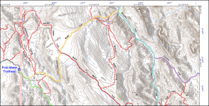
"Go to first water, then to second water ..."
This part seems easy enough. Very clear to me, if "first water" and "second water" have remained the same.

"... then take the old government trail to San Carlos."
Here, I start making assumptions. I'm assuming that the route goes from Second Water Spring to Boulder Trail, since I'm also assuming that men on horseback would want to follow the easiest and most direct route to San Carlos, although I'm wondering why anyone would want to go through the Superstition Mountains to get to San Carlos, which is a long journey east-southeast from Ft. McDowell. Comments are welcome at this point. I might already be diverging far from popular opinion.

016.png
 

Last edited:

skyhawk1251

Sr. Member
Nov 9, 2018
311
669
Kingman, AZ
Detector(s) used
Fisher Gold Bug Pro
Primary Interest:
Prospecting
PART 2 --

"Go to first water, then to second water, then take the old government trail to San Carlos. Where the trail turns south you will see over the point of a ridge a rock standing in the brush that looks like a man. This is where I always leave the trail. Go to the left of the trail and follow up the long ridge and you will come to a saddle. In this saddle is a round Indian ruin of rocks. Go through this saddle and on up a low ridge, and when you get to the highest point of the ridge you can look north and the four peaks are lined up to look as one peak. In the other direction you will see a high needle. In the canyon under you is my hidden camp. You can't get down there because it's too steep, go to the mouth of the canyon and then back. You can find the rock house with very little difficulty. You won't be able to see it until you are right up on it. After you find the camp then come back out of the canyon. (Here Waltz gave a direction to the mine that Holmes and Roberts kept secret.) You will never be able to find the mine until you first find the rock house as the opening is completely hidden. A prospector won't find it because there is no ledge in view. In the mine you will find about $75,000 dollars in gold ore already dug out. I dug the outcropping away and covered all signs of my digging." -- Holmes Manuscript (posted by Matthew Roberts)

"To begin with the first water and second water. Why Waltz told Holmes these clues and to Julia told Green River and Rocky Shallows (German Clues)? Because Holmes knew about these names at the time he was tracking Waltz to his mine. When the trail turns south, Waltz said, "you will see over the point of a ridge", which means behind that point of the ridge is another mountain which has the "rock like a man" landmark. Also, the words "you will see" doesn't mean "you can see." "You will see" is for a future event. If you go closer, you pay more attention, you have binoculars, etc. The best way to find out is to go to the location of the point of the ridge. This Waltz description is the same view from the Perfil Mapa." -- markmar (edited)

"Where the trail turns south you will see over the point of a ridge a rock standing in the brush that looks like a man. This is where I always leave the trail." -- Here, the "directions" are very vague, but I read this sentence to mean that Waltz headed south on the "old government trail to San Carlos." Of course, Waltz conveniently avoids mentioning how far south he traveled on the trail. He is traveling in a canyon, however, that has points of ridges protruding into the canyon bottom. He is not traveling in an arroyo between two ridges that run parallel in close proximity, nor is he traveling on the top of a ridge.

"... you will see over the point of a ridge a rock standing in the brush that looks like a man." -- Here, I agree with markmar. The traveler must be at the point of a ridge before he can see a "rock standing in the brush that looks like a man." The rock and its likeness to a man are not readily apparent. It must be looked for, but I don't believe optical aid is necessary. I don't believe the rock is extremely high up. It is not a feature on a cliff face. It is not the "head of a man." It is "standing" like a statue in the brush. This is where Waltz left the trail, which is in the bottom of a canyon, which has points of ridges protruding into it, leading me to believe the canyon has respectable width. Boulder Canyon was not then known by that name, but it fits the "directions" suitably.

"Go to the left of the trail and follow up the long ridge and you will come to a saddle." -- If Waltz was traveling south in the canyon, turning left would put him heading to the east. I'm assuming "the point of a ridge" and "the long ridge" both refer to the same ridge. My objective now is to travel eastward on a long ridge that will put me on the line where "four peaks are lined up to look as one peak" and a high needle is seen in the other direction.

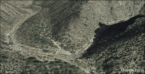
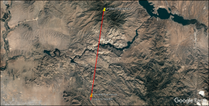
See the two GE images below. One shows "the point of a ridge" as an example. The other shows the line connecting Brown's Peak with Weaver's Needle.

017.png

018.png
 

Last edited:

Idahodutch

Bronze Member
Sep 25, 2019
1,848
4,785
Idaho
Detector(s) used
Whites MXT
Gold Legend
Primary Interest:
Other
PART 2 --


"Where the trail turns south you will see over the point of a ridge a rock standing in the brush that looks like a man. This is where I always leave the trail." -- Here, the "directions" are very vague, but I read this sentence to mean that Waltz headed south on the "old government trail to San Carlos." Of course, Waltz conveniently avoids mentioning how far south he traveled on the trail. He is traveling in a canyon, however, that has points of ridges protruding into the canyon bottom. He is not traveling in an arroyo between two ridges that run parallel in close proximity, nor is he traveling on the top of a ridge.

"... you will see over the point of a ridge a rock standing in the brush that looks like a man." -- Here, I agree with markmar. The traveler must be at the point of a ridge before he can see a "rock standing in the brush that looks like a man." The rock and its likeness to a man are not readily apparent. It must be looked for, but I don't believe optical aid is necessary. I don't believe the rock is extremely high up. It is not a feature on a cliff face. It is not the "head of a man." It is "standing" like a statue in the brush. This is where Waltz left the trail, which is in the bottom of a canyon, which has points of ridges protruding into it, leading me to believe the canyon has respectable width. Boulder Canyon was not then known by that name, but it fits the "directions" suitably.

"Go to the left of the trail and follow up the long ridge and you will come to a saddle." -- If Waltz was traveling south in the canyon, turning left would put him heading to the east. I'm assuming "the point of a ridge" and "the long ridge" both refer to the same ridge. My objective now is to travel eastward on a long ridge that will put me on the line where "four peaks are lined up to look as one peak" and a high needle is seen in the other direction.

See the two GE images below. One shows "the point of a ridge" as an example. The other shows the line connecting Brown's Peak with Weaver's Needle.

View attachment 1945843

View attachment 1945844

Skyhawk,
The Clue about the rock standing in the brush.....
There are more than a couple of ways for that clue to fit.
In your image for example of ?the point of a ridge? (besides a good camp spot :) ), I saw something, below the ridge that runs along the left side of that image, just out of view. I was hiking up canyon on that trail; it was later afternoon. Large rock formations are scattered all over in there, anyway a pretty big rock formation protrudes high enough, that from that trail at canyon floor, looking up, I could see that rock formation as a silhouette against the sky, above the point of that ridge behind it, even though the rock formation was actually at a lower elevation than the ridge behind it.
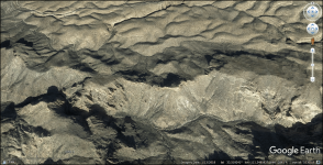
I imagine that if any of us were to look upon the one Waltz was talking about, and from the same angle, we would probably say - oh, I see now. Then shake our head.

I don?t know which perspective for the clue is correct, or a different one, or even if the rock man formation still looks as it once did ???
Wasn?t trying to interrupt, just mentioning another perspective that is possible to apply for that clue; one that I had not realized prior to seeing it recently.
 

Last edited:

skyhawk1251

Sr. Member
Nov 9, 2018
311
669
Kingman, AZ
Detector(s) used
Fisher Gold Bug Pro
Primary Interest:
Prospecting
PART 3 --

"Go to first water, then to second water, then take the old government trail to San Carlos. Where the trail turns south you will see over the point of a ridge a rock standing in the brush that looks like a man. This is where I always leave the trail. Go to the left of the trail and follow up the long ridge and you will come to a saddle. In this saddle is a round Indian ruin of rocks. Go through this saddle and on up a low ridge, and when you get to the highest point of the ridge you can look north and the four peaks are lined up to look as one peak. In the other direction you will see a high needle. In the canyon under you is my hidden camp. You can't get down there because it's too steep, go to the mouth of the canyon and then back. You can find the rock house with very little difficulty. You won't be able to see it until you are right up on it. After you find the camp then come back out of the canyon. (Here Waltz gave a direction to the mine that Holmes and Roberts kept secret.) You will never be able to find the mine until you first find the rock house as the opening is completely hidden. A prospector won't find it because there is no ledge in view. In the mine you will find about $75,000 dollars in gold ore already dug out. I dug the outcropping away and covered all signs of my digging." -- Holmes Manuscript (posted by Matthew Roberts)

"Go to the left of the trail and follow up the long ridge and you will come to a saddle. In this saddle is a round Indian ruin of rocks. Go through this saddle and on up a low ridge, and when you get to the highest point of the ridge you can look north and the four peaks are lined up to look as one peak. In the other direction you will see a high needle." -- (I'll get to this section of the manuscript later on, but I do want to mention that I've found "a round ... ruin of rocks" using GE, although it's location doesn't agree with the "directions" in the manuscript.

"Skyhawk -- The clue about the rock standing in the brush ... there are more than a couple of ways for that clue to fit. In your image for (an) example of the point of a ridge I saw something, below the ridge that runs along the left side of that image, just out of view. I was hiking up canyon on that trail; it was later afternoon. Large rock formations are scattered all over in there, anyway, a pretty big rock formation protrudes high enough, that from that trail at canyon floor, looking up, I could see that rock formation as a silhouette against the sky, above the point of that ridge behind it, even though the rock formation was actually at a lower elevation than the ridge behind it. I imagine that if any of us were to look upon the one Waltz was talking about, and from the same angle, we would probably say -- oh, I see now. I don't know which perspective for the clue is correct, or a different one, or even if the rock man formation still looks as it once did. Wasn't trying to interrupt, just mentioning another perspective that is possible to apply for that clue; one that I had not realized prior to seeing it recently." -- Idahodutch
First of all, I should make it clear that I think the "directions" contained in the Holmes Manuscript are worth diddly-doo. Essentially, I'm just playing "let's pretend" here, treating the "directions" as completely valid, and working with what we've been given. I want readers to feel free to jump in at any time to add their own perspective. I'm hoping to see some general agreement on specific points contained in the "directions." If there is no general agreement on anything, then I think it can be concluded that the "directions" are worthless and cannot be understood by anyone.

Your observation of the "rock formation as a silhouette against the sky", Idahodutch, shows that you have keen eyes, and that you were paying close attention to your surroundings. My opinion concerning "rock standing in the brush that looks like a man" is that it has been purposely destroyed and it is no longer as it was. Someone, soon after the manuscript was made public, might have found it, and thinking that they were close to finding the LDM, made sure nobody else could make use of that "clue." My understanding is that Waltz was able to easily walk over to the rock, and he then chiseled two eyes to make it look more like a man. So, I have concluded that the rock was not much higher than a man, and it stood somewhere between the wash in the canyon and the canyon wall, the place favored by vegetation growing in canyons. It was not prominent, but it could be found by someone who was expressly looking for it.

As I continue attempting to make some sense of the "directions", I'm giving priority to the ground covered by the line connecting Brown's Peak and Weaver's Needle. I'm also favoring spots on that line well away from Weaver's Needle as a starting point. Waltz didn't say how far south he went on the trail when it turned south, so I'm assuming for now that it wasn't very far. Also, Indians favored easy access to water for their encampments (in this saddle is a round Indian ruin of rocks), which makes me want to favor locations closer to the Salt River, rather than closer to Weaver's Needle.
 

markmar

Silver Member
Oct 17, 2012
4,117
6,259
Primary Interest:
All Treasure Hunting
For those who are interested, the round ruin of rocks, which I doubd is Indian, is still there in that saddle.
Waltz was out of time when was given the route to Holmes, and told him to go to that saddle, not the datail to approach but just to search for that specific saddle on that ridge. When Waltz said " to a saddle ", meant one from many or from few.

Here is a GE image of that round ruin. When you will find it, just climb down and you will find yourself in the region where the inclined shaft and the other mine are located.

attachment.php
 

skyhawk1251

Sr. Member
Nov 9, 2018
311
669
Kingman, AZ
Detector(s) used
Fisher Gold Bug Pro
Primary Interest:
Prospecting
PART 4 --

"Go to first water, then to second water, then take the old government trail to San Carlos. Where the trail turns south you will see over the point of a ridge a rock standing in the brush that looks like a man. This is where I always leave the trail. Go to the left of the trail and follow up the long ridge and you will come to a saddle. In this saddle is a round Indian ruin of rocks. Go through this saddle and on up a low ridge, and when you get to the highest point of the ridge you can look north and the four peaks are lined up to look as one peak. In the other direction you will see a high needle. In the canyon under you is my hidden camp. You can't get down there because it's too steep, go to the mouth of the canyon and then back. You can find the rock house with very little difficulty. You won't be able to see it until you are right up on it. After you find the camp then come back out of the canyon. (Here Waltz gave a direction to the mine that Holmes and Roberts kept secret.) You will never be able to find the mine until you first find the rock house as the opening is completely hidden. A prospector won't find it because there is no ledge in view. In the mine you will find about $75,000 dollars in gold ore already dug out. I dug the outcropping away and covered all signs of my digging." -- Holmes Manuscript (posted by Matthew Roberts)

"For those who are interested, the round ruin of rocks, which I doubt is Indian, is still there in that saddle. Waltz was out of time when was given the route to Holmes and told him to go to that saddle, not the details to approach, but just to search for that specific saddle on that ridge. When Waltz said "to a saddle", he meant one from many or from few. Here is a GE image of that round ruin. When you will find it, just climb down and you will find yourself in the region where the inclined shaft and the other mine are located." -- markmar

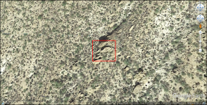
I am in agreement, markmar. Waltz did not tell Holmes "the first saddle, the second saddle, etc.", just "a saddle", but it had to be a saddle with a round Indian ruin of rocks. The ruin of rocks seems to mark the end of the trail and the location of the mine. The ruin of rocks could have been an old Peralta trail marker. I'm looking at long ridges that lead eastward to the line connecting Brown's Peak with Weaver's Needle. I'm searching from north to south in the mountains. I've looked at one "long ridge" near the northern boundary of the wilderness area, and it looks like it could be traveled from one end to the other without too much difficulty, but no point on the ridge is high enough to see Weaver's Needle to the south. A screenshot of that ridge is below. It has an interesting feature on its south slopes (second image, red box). GPS coordinates are at the bottom of the images.

21.png

20.png
 

Idahodutch

Bronze Member
Sep 25, 2019
1,848
4,785
Idaho
Detector(s) used
Whites MXT
Gold Legend
Primary Interest:
Other
Skyhawk,
I?ve been waiting for others to give thoughts .... I?ll chime in with some thoughts, but these are just some thoughts;
I think the directions are pretty vague, but do get better towards the end. The descriptions of things get more specific.

It is interesting that the directions for following the long ridge, after going left of the trail .... only say you will come to a saddle. They do not say the saddle is part of that long ridge. They do say the saddle ties into a low ridge though.

Since the ?Rock Man? does not seem to have consensus that I have seen,
that makes it hard to lock in much unless you actually ?come to a saddle?.

The directions do not elaborate on the approach/transition from long ridge, to the saddle.
Without confirmation from other clue sources.....it has the flavor of a bunch of dead ends.

Following Bicknells article, the one that claimed to have Julia?s account.....without confirmation from other clue sources, has a similar flavor.

I feel fortunate that I sincerely do not feel bias about one over the other.
From what I can tell, they compliment/complete each other .... if used together.

Homes is very good, once the saddle is reached, but poor for detailing the path there.
Bicknell?s gets to vacinity, but doesn?t mention the saddle, or much detail to be able to confirm the end of the path.
Together, if they are real, will come together.

You asked for general consensus....In my opinion, they are both real.
Both with good points and bad points.
Idahodutch
 

skyhawk1251

Sr. Member
Nov 9, 2018
311
669
Kingman, AZ
Detector(s) used
Fisher Gold Bug Pro
Primary Interest:
Prospecting
PART 5 --

"Skyhawk -- I think the directions are pretty vague, but do get better towards the end. The descriptions of things get more specific. It is interesting that the directions for following the long ridge, after going left of the trail only say you will come to a saddle. They do not say the saddle is part of that long ridge. They do say the saddle ties into a low ridge though.

Since the "Rock Man" does not seem to have consensus that I have seen that makes it hard to lock in much unless you actually come to a saddle. The directions do not elaborate on the approach/transition from the long ridge to the saddle. Without confirmation from other clue sources it has the flavor of a bunch of dead ends.

Following Bicknell's article, the one that claimed to have Julia's account without confirmation from other clue sources, has a similar flavor. I feel fortunate that I sincerely do not feel bias about one over the other. From what I can tell, they compliment/complete each other, if used together. Holmes is very good, once the saddle is reached, but poor for detailing the path there. Bicknell's gets to the vicinity, but doesn't mention the saddle, or much detail, to be able to confirm the end of the path.

You asked for general consensus. In my opinion, they are both real. Both with good points and bad points." -- Idahodutch

"Where the trail turns south you will see over the point of a ridge a rock standing in the brush that looks like a man." -- Here, I think the text that reads, "a rock standing in the brush that looks like a man" can be disregarded. It's useless. I'll bet a pile of greenbacks that the rock is long gone -- smashed to pieces by some Dutch hunter long ago, who thought that the LDM was just ahead on the trail.

That then brings us to finding the ridge described in the "directions." A search for that ridge will be a random one, and very tedious. The ridge presumably will lead eastward from a canyon, and the ridge will have a saddle, which is a lower elevation between and connecting two higher elevations. From a point near the saddle lies the line connecting Four Peaks and Weaver's Needle, and both landmarks can be seen.

I'm still looking for that "long ridge." My assumption that Boulder Canyon gives access to the "long ridge" seems to be wrong. The farther south I go in Boulder Canyon it seems impossible to find a "long ridge" that extends far enough eastward to cross the Four Peaks/Weaver's Needle line. So, now I'm giving priority to canyons that run east of Boulder Canyon. Also, farther south in the wilderness area, the "long ridge" would not need to be extremely high to view Four Peaks and Weaver's Needle.

My conclusion that the "directions" contained in the Holmes Manuscript are useless stands at this point. Holmes supposedly was given additional details about how to find the mine and he never found it. The "directions" were useless to him, so we should not expect them to point the way. Maybe Waltz was pulling one, last "dirty trick" before he died.
 

Doc4261

Hero Member
Nov 5, 2015
582
578
Primary Interest:
All Treasure Hunting
PART 4 --


I am in agreement, markmar. Waltz did not tell Holmes "the first saddle, the second saddle, etc.", just "a saddle", but it had to be a saddle with a round Indian ruin of rocks. The ruin of rocks seems to mark the end of the trail and the location of the mine. The ruin of rocks could have been an old Peralta trail marker. I'm looking at long ridges that lead eastward to the line connecting Brown's Peak with Weaver's Needle. I'm searching from north to south in the mountains. I've looked at one "long ridge" near the northern boundary of the wilderness area, and it looks like it could be traveled from one end to the other without too much difficulty, but no point on the ridge is high enough to see Weaver's Needle to the south. A screenshot of that ridge is below. It has an interesting feature on its south slopes (second image, red box). GPS coordinates are at the bottom of the images.

View attachment 1946018

View attachment 1946019

My thoughts is this could be it. Happens to be the spot I believe is in the h/p map. Who knows tho.
Screenshot_20210908-211147.png
 

wrmickel1

Bronze Member
Nov 7, 2011
1,854
1,392
Jamestown ND
Detector(s) used
Garrett 2500
Primary Interest:
Other
Skyhawk,
I?ve been waiting for others to give thoughts .... I?ll chime in with some thoughts, but these are just some thoughts;
I think the directions are pretty vague, but do get better towards the end. The descriptions of things get more specific.

It is interesting that the directions for following the long ridge, after going left of the trail .... only say you will come to a saddle. They do not say the saddle is part of that long ridge. They do say the saddle ties into a low ridge though.

Since the ?Rock Man? does not seem to have consensus that I have seen,
that makes it hard to lock in much unless you actually ?come to a saddle?.

The directions do not elaborate on the approach/transition from long ridge, to the saddle.
Without confirmation from other clue sources.....it has the flavor of a bunch of dead ends.

Following Bicknells article, the one that claimed to have Julia?s account.....without confirmation from other clue sources, has a similar flavor.

I feel fortunate that I sincerely do not feel bias about one over the other.
From what I can tell, they compliment/complete each other .... if used together.

Homes is very good, once the saddle is reached, but poor for detailing the path there.
Bicknell?s gets to vacinity, but doesn?t mention the saddle, or much detail to be able to confirm the end of the path.
Together, if they are real, will come together.

You asked for general consensus....In my opinion, they are both real.
Both with good points and bad points.
Idahodutch

That's your mistake, Julia and Holmes never hunted the same area. They were the first of dutch hunters to look in two different directions.
Holmes was trying to match clues to a different area as your doing today. If you pass the 3 red hills you are to far east. And if you go to the face of Superstition mountain and walk straight north you will see the man standing, Clays favorite area for years.

Babymick1
 

Idahodutch

Bronze Member
Sep 25, 2019
1,848
4,785
Idaho
Detector(s) used
Whites MXT
Gold Legend
Primary Interest:
Other
That's your mistake, Julia and Holmes never hunted the same area. They were the first of dutch hunters to look in two different directions.
Holmes was trying to match clues to a different area as your doing today. If you pass the 3 red hills you are to far east. And if you go to the face of Superstition mountain and walk straight north you will see the man standing, Clays favorite area for years.

Babymick1

Since neither Julia or Holmes found the mine, I think it is safe to conclude that Waltz?s directions lead to a place ....
That was not where Holmes or Julia were looking ...
Why do so many want to look where they looked?
I?m ok with my progress trying to follow the clues :)

It is interesting to hear the different views, sometimes helps the thought processing.
Maybe we?ll find out soon enough, maybe not :occasion14:
 

Doc4261

Hero Member
Nov 5, 2015
582
578
Primary Interest:
All Treasure Hunting
Since neither Julia or Holmes found the mine, I think it is safe to conclude that Waltz?s directions lead to a place ....
That was not where Holmes or Julia were looking ...
Why do so many want to look where they looked?
I?m ok with my progress trying to follow the clues :)

It is interesting to hear the different views, sometimes helps the thought processing.
Maybe we?ll find out soon enough, maybe not :occasion14:


Same as the story of where waltz partner is buried. Holmes found him supposedly north of the salt river at hidden water. Yet Petratch claimed he was buried 300 ft south of the mine. There are big differences in the 2 camps of waltz stories.. :dontknow: I tend to be in the Julia camp on this one. Just cuz the body found at hidden water I have a feeling was a worker for the Peraltas.
 

Last edited:

markmar

Silver Member
Oct 17, 2012
4,117
6,259
Primary Interest:
All Treasure Hunting
PART 4 --


I am in agreement, markmar. Waltz did not tell Holmes "the first saddle, the second saddle, etc.", just "a saddle", but it had to be a saddle with a round Indian ruin of rocks. The ruin of rocks seems to mark the end of the trail and the location of the mine. The ruin of rocks could have been an old Peralta trail marker. I'm looking at long ridges that lead eastward to the line connecting Brown's Peak with Weaver's Needle. I'm searching from north to south in the mountains. I've looked at one "long ridge" near the northern boundary of the wilderness area, and it looks like it could be traveled from one end to the other without too much difficulty, but no point on the ridge is high enough to see Weaver's Needle to the south. A screenshot of that ridge is below. It has an interesting feature on its south slopes (second image, red box). GPS coordinates are at the bottom of the images.

attachment.php


attachment.php

Actually, the round ruin of rocks is an arrastra, not made by the Peraltas, but is much older. And is not the only arrastra on that ridge. There are plenty of them in that region. I can say for certain how every flat place on that mountain has at least one arrastra, and this make more difficult the research for the LDM. Usually for a single mine they would used from two to four arrastras, depending on how many would been working the mine. For example, the San Pedro mine of Tumacacori had four arrastras.
So, I would not count much on this clue, but more on the other known. Now, for the four peaks clue as to be seen lined as one peak, you mentioned Brown peak in your measurements. IMO, you have chose wrong that peak, not how this would make more difference as direction, but you have to know how to see the four peaks as one peak, you have to look for the proper elevation and distance in regards to see the first peak from the south to cover the other peaks to the north.
 

Last edited:

skyhawk1251

Sr. Member
Nov 9, 2018
311
669
Kingman, AZ
Detector(s) used
Fisher Gold Bug Pro
Primary Interest:
Prospecting
"Actually, the round ruin of rocks is an arrastra, not made by the Peraltas, but is much older, and is not the only arrastra on that ridge. There are plenty of them in that region. I can say for certain how every flat place on that mountain has at least one arrastra, and this makes more difficult the research for the LDM. Usually for a single mine they would use from two to four arrastras, depending on how many would have been working the mine. For example, the San Pedro mine of Tumacacori had four arrastras. So, I would not count much on this clue, but more on the other known.

Now, for the four peaks clue as to be seen lined as one peak, you mentioned Brown's peak in your measurements. IMO, you have chose wrong that peak, not how this would make more difference as direction, but you have to know how to see the four peaks as one peak, you have to look for the proper elevation and distance in regards to see the first peak from the south to cover the other peaks to the north." -- markmar

In my research, I found that drawing a line to connect Brown's Peak with Weaver's Needle comes "close enough" to making the four peaks appear as one peak. As I posted earlier, anyone can use GE to landmark/pushpin the summits of all four peaks, then draw a line to connect all four summits. Take that line and extend it farther south to Weaver's Needle and beyond. Screenshots and an image editor/viewer will be necessary to do this. As far as distance is concerned to see four peaks as one peak, that is not a critical factor. It's not necessary for the peak farthest south to completely cover the peaks to the north, because the naked eye would see and resolve only one peak. Optical aid would be necessary to see if the peaks to the north weren't completely covered, and even if this was the case the compass bearing to Weaver's Needle would be the same. The distance from Weaver's Needle is critical. The viewer's elevation and distance must be "correct", so that no intervening peaks hide Weaver's Needle. In the Holmes Manuscript "directions", the words are "high needle." These words could indicate that the entire pinnacle portion of Weaver's Needle should be visible from above the LDM.

A TRIBUTE TO MATTHEW ROBERTS --

Here, I'd like to pay tribute to Matthew Roberts for his many carefully researched and detailed submissions to this forum. I've been reading some of Matthew's contributions posted many years ago, and other forum members might want to do the same. If so, search for threads started by Matthew to find the best ones. Some of those threads are:

http://www.treasurenet.com/forums/lost-dutchman-s-mine/538697-military-trail.html

http://www.treasurenet.com/forums/lost-dutchman-s-mine/507181-ted-cox-ridge-pit-mine.html

http://www.treasurenet.com/forums/lost-dutchman-s-mine/569006-alfred-lewis-discovery-old-mammoth-mine-1949-1950-a.html

http://www.treasurenet.com/forums/lost-dutchman-s-mine/598245-jim-hatt-s-cave.html

http://www.treasurenet.com/forums/lost-dutchman-s-mine/548689-ray-howland-adolph-ruth-mystery.html
 

Idahodutch

Bronze Member
Sep 25, 2019
1,848
4,785
Idaho
Detector(s) used
Whites MXT
Gold Legend
Primary Interest:
Other
In my research, I found that drawing a line to connect Brown's Peak with Weaver's Needle comes "close enough" to making the four peaks appear as one peak. As I posted earlier, anyone can use GE to landmark/pushpin the summits of all four peaks, then draw a line to connect all four summits. Take that line and extend it farther south to Weaver's Needle and beyond. Screenshots and an image editor/viewer will be necessary to do this. As far as distance is concerned to see four peaks as one peak, that is not a critical factor. It's not necessary for the peak farthest south to completely cover the peaks to the north, because the naked eye would see and resolve only one peak. Optical aid would be necessary to see if the peaks to the north weren't completely covered, and even if this was the case the compass bearing to Weaver's Needle would be the same. The distance from Weaver's Needle is critical. The viewer's elevation and distance must be "correct", so that no intervening peaks hide Weaver's Needle. In the Holmes Manuscript "directions", the words are "high needle." These words could indicate that the entire pinnacle portion of Weaver's Needle should be visible from above the LDM.

A TRIBUTE TO MATTHEW ROBERTS --

Here, I'd like to pay tribute to Matthew Roberts for his many carefully researched and detailed submissions to this forum. I've been reading some of Matthew's contributions posted many years ago, and other forum members might want to do the same. If so, search for threads started by Matthew to find the best ones. Some of those threads are:

http://www.treasurenet.com/forums/lost-dutchman-s-mine/538697-military-trail.html

http://www.treasurenet.com/forums/lost-dutchman-s-mine/507181-ted-cox-ridge-pit-mine.html

http://www.treasurenet.com/forums/lost-dutchman-s-mine/569006-alfred-lewis-discovery-old-mammoth-mine-1949-1950-a.html

http://www.treasurenet.com/forums/lost-dutchman-s-mine/598245-jim-hatt-s-cave.html

http://www.treasurenet.com/forums/lost-dutchman-s-mine/548689-ray-howland-adolph-ruth-mystery.html

Skyhawk,
I have thought about the part of ?In the other direction you will see a high needle.?
It seems the general consensus of ?other direction? is that of being equal with ?opposite direction?, but that?s not what was written down. To me, the terminology ?other direction? is vague, and not precise.
My point is just; if someone only searches the ?opposite? scenario, they may be eliminating their chances.....

If it?s ever found, I guess we?ll see how a lot of the clues we?re to be applied.
Until then, be careful not to accidentally eliminate possibilities:)
Idahodutch
 

skyhawk1251

Sr. Member
Nov 9, 2018
311
669
Kingman, AZ
Detector(s) used
Fisher Gold Bug Pro
Primary Interest:
Prospecting
"Skyhawk -- I have thought about the part of "in the other direction you will see a high needle." It seems the general consensus of "other direction" is that of being equal with "opposite direction", but that's not what was written down. To me, the terminology "other direction" is vague, and not precise. My point is just, if someone only searches the "opposite" scenario, they may be eliminating their chances. If it's ever found, I guess we'll see how a lot of the clues were to be applied. Until then, be careful not to accidentally eliminate possibilities." -- Idahodutch

You are 100% correct. Since the "clues" are all we have to work with, and as dubious as we might be as to their validity, they can be used as a starting point to investigate areas of "higher probability" for the location of the LDM, but their lack of reliability means that areas of "lower probability" are not excluded. I agree with you that if the LDM is ever found many of the "clues" will fall into place. The LDM will not be found because of the "clues." I'm thinking that over time erosion takes place, ironwood logs rot, and suddenly a sealed shaft could be revealed and found by someone not expressly searching for the LDM, but who is just doing some "hard-core" hiking through the mountains. Stranger things have happened. That's why I would advise anyone traveling through those mountains to be very observant and not to disregard the smallest "anomaly" they might see.
 

Idahodutch

Bronze Member
Sep 25, 2019
1,848
4,785
Idaho
Detector(s) used
Whites MXT
Gold Legend
Primary Interest:
Other
Skyhawk,
As far as I know, there are at least 2 landmarks, south of Waltz?s bonanza.
According to Waltz, they can be seen from a place above his mine;
- one is ?high needle ?
- another is ?peak with hole through it? (this is part of the German clues, and translation is debated).

I do not believe Waltz was talking about the same landmark, but 2 different landmarks.
One landmark, the high needle, seems to have the general consensus of being Weaver?s Needle.
The other landmark, does not have consensus from the Dutch hunting community, that I have noticed.

So a peak with a hole through it ..... and perhaps not too far from Weavers Needle, but off in the distance, yet can see it still .... the hole through it.
I believe something caught Waltz?s eye one of the times he was above the mine.
Something that let him notice the peak with a hole through it.
Southerly of Four Peaks, is Weavers Needle, but also southerly is Palomino Mountain, home to Aylor?s Arch.
Later in the afternoon, and perhaps only certain times of year, Aylor?s Arch lights up like a lit house window at dusk.
It would catch your eye for sure, especially as it is lighting up :)

Try drawing a straight line from 4 peaks, to Palomino Mountain ..... it looks to go near that ?hole? you found, depending what part of Palomino, your line goes to. :)
 

Last edited:

markmar

Silver Member
Oct 17, 2012
4,117
6,259
Primary Interest:
All Treasure Hunting
The German clue in regards to the saddle obove the LDM, says "

" Von meiner lagerstatte wenn du im sattel sitz kannst du in ferne im suden durch ein loch vom Berg sehen " . This sentence is translated in English ( and Black Line who is a German citizen and also a Tnet member , confirmed this translation ) as:

" From my storage area when you sit in the saddle you can see in the distance to the south through a hole in the mountain ".

The first translation " From my camp in the saddle you will see a peak in the distance to the south with a hole " is mistranslated and send many good people in the wrong place, and those who continue to support this translation are wasting their money and time.

Actually, the hole in the mountain is the tunnel where the miners were leaving their mining gear, and was the passage from the saddle to the trail downhill to the mines. This tunnel was mentioned by Waltz to Julia, telling her " The tunnel entrance is supposed to be shaped like a bell ".
Also, this tunnel/passage was mentioned by Doc Thorne in Jim Bark's notes. There are also another stories who mention that tunnel, like the Two Soldiers and Joe Deering's.
So, this clue is one which was validated and should be taken in consideration more than other.
 

Last edited:

Top Member Reactions

Users who are viewing this thread

Top