Dick Holmes clues

Ramiro valdez

Full Member
Aug 26, 2020
182
103
San Antonio, Texas
Primary Interest:
All Treasure Hunting
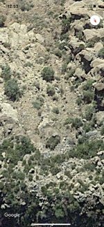
Ok, well I agree with, Mathew Roberts, that Waltzā€™s gold mine clues should be the main focus when looking for the LDM since they were recorded. All other non recorded clues that were passed on by the Dutchman to his friends can only add to the story of recorded clues. All these clues can become worthless if you donā€™t know the area or donā€™t have a map. But it is important to note that there is a map which was given to Julia Thomas. In fact there were several maps one in particular had an extra clue about a rock formation that had a hole in it called the eye of the needle to help his friends further identify the area in question. Why? Because he though that their might be a possibility that they would miss the Rock Horse canyon. Before you give directions itā€™s a good idea to draw a map, which he did. You can find the map or maps on the web and you should get yourself familiar with it if your going to follow these clues. The map should be the first focus and the clues should follow suit. The reason why Waltz gave clues, instead of proper directions, was to keep the gold mine a secret from others except his friends. He believed that they had enough clues plus a map to get them to the location of the mine safely. He gave them specific instructions to follow when they got close to the gold mine. This instructions were to be followed to keep them safe from getting killed by the Indians or anyone who might of found the location. The problem with this plan was that no one in the party could navigate, read a cipher map, or understand the clues that went along with the map. The clues are supposed to be used with the map in order to located the direction of the goldmine. Some, in the beginning were not aware that Waltz actually gave away the coordinates to his gold mine and for that you need two lines of direction. The first one was on the map and the second one was on his finger when he pointed to the east. If you were a good navigator you would simply follow this straight line in the direction that he pointed by using a compass. All you needed then was the second directional line which was on his map. The map contained the starting point which was north of his farm located on the north side of the salt river near the Nail Creek Crossing. These two lines would eventually intercept each other within a 3 square mile area of marginal error which should be sufficient to locate. The finger direction can go along way, you just have to find the stopping point. The focus should first be the map or maps followed by the recorded clues then followed by other clues that would only add to the story of where the mine was located. The first water is a natural spring water hole called black Mesa located within two miles to the north of his farm. Within three miles north of the Mesa spring you will find Oak Creek spring water hole. Oak creek water hole lies close to an old government trail that leads toward the east in the direction of Aztec peak. The government trail would go from one fort to the other circling the high ridge mountains. Waltz would pick up the trail not far from the Oak Creek water hole. The trail would go east working its way around a cow farm before turning south. At the turn the trail would split in two, one trail would turn south towards Fort Apache in the direction of San Carlos. The other trail would proceed north climbing the Sierra Ancha Mountain ridge towards a small saddle. The first lookout camp laid towards the east below the saddleā€™s steep drop. Waltz wanted them to spy on the camp first before going throughout the saddle to a higher point that would allowed them to see more of the surrounding area for unwanted traffic before going down into the lookout camp. The camp was located in the center of a turn around outlook Indian post. There is a large rock formation in the center of this turn around and in the forward section of the rock formation you will find the cotton wood stand where Waltz hid spying on the canyon. He instructed them to go towards the mouth of the canyon when all was clear to locate the ruins and not to go into the canyon, but to proceed towards the second camp near the Armor Corral Spring located towards the east where they could get a good view of anyone coming towards the mine from the east.They were supposed to approach the rock horse canyon from the east across from the hidden canyon wall where they could make sure no one was working the mine before proceeding to locate the secondary secret passageway by way of the ruins which would lead them onto the ledge. The ledge would lead them to the mine so they could grab the gold that Waltz left behind, as he was used to doing, so they wouldnā€™t have to spend too much time in the mine for safety reasons. Call me crazy but crazy likes to locate meaningful treasure locations. So, Iā€™m going to just wait for another crazy person to take the challenge of discovery. If no one takes the challenge, then I'm just going to say the same thing Waltz, said ā€œ your not going to find the mine ā€œ. To the north as the elevation rises you will spot the eye of the needle which was supposed to let them know that they had gone too far and missed the canyon. The rest of the clues you can figure out yourself because it can only add and never take away from the LDM story. Amazingly! The cotton wood stand or blind is still there!!
FA29DDEC-4E75-4BEA-9AA5-EC8FF149C0F8.jpg


B5CCC8C4-4387-4AA7-BDD9-EF3C025C4B16.jpg
 

Doc4261

Hero Member
Nov 5, 2015
582
578
Primary Interest:
All Treasure Hunting
No Doc

No Doc

I'd never need funds, But if you need schooling I'd teach you for a price.

Mr Tuttle's last video clearly took the Holmes Clan out of the picture.

Babymick1

Taking he Holmes clues out of picture would be a mistake. Just saying... But what do I know.?? I wouldn't put any stock in anything I say.
 

Ramiro valdez

Full Member
Aug 26, 2020
182
103
San Antonio, Texas
Primary Interest:
All Treasure Hunting
Doc
It's the best thing you can do.
I just saw Mr Tuttleā€™s video and I understand his views by what he read. According to Dickā€™s Holmes character, I believe he had it coming! LoL!!! As a good treasure hunter myself, I like to hear what everyone has to say. But donā€™t loose your focus on the character because part of his story maybe true. He gave Holmes a low rating based on what he believed and read, which is ok, by me. He invited everyone to do the same which is the right thing to do. If your just a reader your going to fall in the same group as Mr Tuttle, but if your a treasure clue hunter your going to pass on a lot of information that is not going to help you. By that I mean to stay focus and only take that information which makes sense because in away we all lie bit or more especially writers, no offenses, Roberts. That is an honest statement because writers have to sell the story and it must sound good or they wonā€™t write it. Nobody is going to write my story because it doesnā€™t sound go or itā€™s not in black and white, but I donā€™t care about that right now! Because I Need to stay focus on my personal mission just like everyone thatā€™s looking for the LDM should. So we or I am going to help define the map that was posted originally on this thread, soon! Stay focus!!!
 

wrmickel1

Bronze Member
Nov 7, 2011
1,854
1,392
Jamestown ND
Detector(s) used
Garrett 2500
Primary Interest:
Other
Ramiro

That map is bogus, as all that came from that camp is. As I've always said, Their was no need for Waltz to cross the salt river. The only map or maps that are legitimate are the Peralta's.

Babymick1
 

Ramiro valdez

Full Member
Aug 26, 2020
182
103
San Antonio, Texas
Primary Interest:
All Treasure Hunting
Ramiro

That map is bogus, as all that came from that camp is. As I've always said, Their was no need for Waltz to cross the salt river. The only map or maps that are legitimate are the Peralta's.

Babymick1
What is the reason for him staking his farm on the north side of the Salt river nail creek crossing. One of the so call peralta stones has the face of the rock horse hidden canyon which is located east of the Sierra Ancha mountain ridge. This same face is on waltz map which was originally found on a stone transcribed on to a ledger by one of the Peraltaā€™s family member. They never claimed that the map was originally thereā€™s. Maps that carry the Peralta name on them are Peraltaā€™s maps and they only correspond to the superstitious mountains. Waltz ā€˜s maps do not point you in the direction of the superstitious mountains. His clues do not point you in the direction of the superstitious mountains. The rock horse hidden canyon is not in superstitious mountains. The four peaks becoming one can only be seen from the southeast and its exact angle is inscribed in one of waltzā€™s maps. The direction they face is towards the rock horse canyon in the Sierra Ancha mountain range. Any map that points to the east has to do with waltz hidden gold mine. There is no guessing game as to the four peaks angle of direction because waltz drew them on the original map that he had to help his friends, the only problem was that they did not have a satellite to see the angle. There is no excuse now because you can clearly see what he was talking about. The drawings of the three so called simple cipher maps like the one on this thread are supplemental addition that Waltz made to help his friends find the location but they were supposed to use it with original maps that he gave them. He fooled everyone while he was alive and his is going to do the same as long as people keep advertising the superstitious mountains. You will never find the mine if you never cross salt river into the Sierra Ancha mountains. I am ok if you donā€™t believe in this because when the time comes and it will someone will find the gold mine. And when they do everything will make sense. The map that you see here on this thread has three iconic recognizable rock structures. But only one is more descriptive than the others. The reason for that is that who ever drew this map wanted the individual to go to the miners needle rock structure so you could see the exact view that is on this map. You might as well get rid of weaverā€™s needle because it is not the main focus. When you position yourself on the left of the miners needle summit you will look to the east and you will find the mountain ridge saddle as on this map located at a higher elevation than the miner needle rock structure. At this point you should know that your looking at the Sierra Ancha Mountain ridge way beyond the salt river and as Waltz said once you go through the saddle on a higher point you will see to the northwest the four peaks that you see on this map as a clue to what you must do to know that your are in the right place. The only one that could have drawn this particular map was Waltz because he was the only one that new the direction and place of where his gold mine was hidden. Mr Tuttle was right the whole story coming from all angles became a mess not to include that the Indians were very helpful in helping you go towards the wrong direction. But you know that Mr Tuttle believes in what he believes and you Mick believe in what you believe and I believe in this and the future will decide who will be wrong. My plans were not to explain everything at one time but because of you, Mick, I might as well say it all at one time. So the thread of this particular map is done no need to bring it up again.
 

Last edited:

wrmickel1

Bronze Member
Nov 7, 2011
1,854
1,392
Jamestown ND
Detector(s) used
Garrett 2500
Primary Interest:
Other
Ramiro

Your name almost translates into tomato šŸ… almost, But I suppose Waltz built his home by the river for a good water source livestock gardening drinking ect. It was 1860's
But it was on the north side so like I said Waltz had no need to cross the Salt River.

Babymick1
 

Top Member Reactions

Users who are viewing this thread

Top