OP
OP
-Ki-
Hero Member
- Feb 12, 2009
- 642
- 574
- Detector(s) used
- MD & Handwand "CaveHunter"Hiker" SonyDigital SLR
- Thread starter
- #41
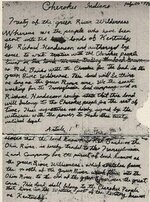
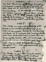
Re: Indians of the Swift era... (Trails & Great Shawnee Cave)
Here is a great link "Shawnee History"
http://www.tolatsga.org/shaw.html
Here is a great link "Shawnee History"
http://www.tolatsga.org/shaw.html