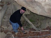
Waybill to the Swift Mines
In doing research on the swift mines, i came across this manuscript that was given by Chief Joseph Brant of the Mohawk Tribe. 1804
(I am keeping the wording as it was put down in the waybill).
At several places i will add ( ? )
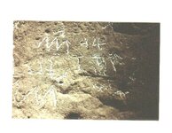
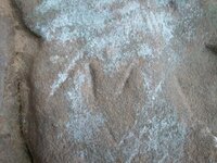
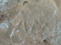
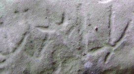
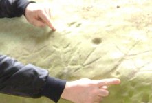
A diagram, given by Chief Joseph of the indian tribes, of four silver mines. You will go to the little knoway (little kanawa river?) and then you will find the maps of the silver mines in kentucky,(there must be maps carved at one of the fords along the Kanawa river?) strate waybills to the same. These mines are 10 and a half suns west. you will come down to the forks of great sanda river, thence up said river to where you will find a crane cut on a stone which will be found at the mouth of a branch. thence three quarters of a mile where a line of rock seems to cross the river. than turn your face to the north and you will find a snake trail or a rainbow in the face of the cliff, than go to the lower corner of the rock house. set your face to the east, w (walk?) 70 paces and you will find a rock on its edge with a crevice behind it, then go to the wast (or does he mean east?) end of the rock house to the corner, than turn your face to the west and step 2p paces ( could it be 20 or 200 paces?) west and behind this rock we hid four barrels of money. than go out of the rock house east, than go north to the top of the point binch ( front bench?) of the cliff you will have to climb up a ladder, then set your face to the west, which will bring you into a rock house, go to the west end and you can pitch a rock into the river. look in the rock house and you will see three ceder trees, if the paleface has not cut them down. (why look in the rockhouse at three trees then climb down and cross the river?) than climb down and cross the river on the line of rock and climb up steps and down steps, then go southwest a quarter mile and you will come to a gap in a low place in the cliff some distance from the creek. this gap is some 36 feet across, the gap some 4 feet wide and has a lid on it and is some 18 feet high, the creek and X and the river forms a horse shoe bend with some 45 acres of ground in it. ( nice place to bury something?) than go to the line of rock and go up the left hand side of the river. than come down the river (why go up than come back down?) three hundred paces and you will come to the mouth of a creek that leads west and runs into the river east, go up the river to the gap with a lid on it and then go up the creek and you will come to a place you will have to climb down on a ladder. than you go up the creek a small distence and you will find a large rock house forming to the south, which did have two or three corner rocks pointing doun into a hole thirty-five feet in the hole is the indian mine. go up this creek and you will find a lick on the right hand, then set your face south and go 30 paces south and you will cross a silver mine on its edge, then go up the creek two hundred yards and you will see in a spring running out of a crack of a rock, then turn your face east and you will see two large rocks standing on a point 253 yards, than you will see three large cliffs, one in your face, one on the right faces the north and the one left faces northeast, then go up the left hand fork one and a quarter miles and you will see a oval rock, then go up the creek a few spaces and you will see a brake in the cliff to your left hand, then climb up the scale way now a road. go east to the top of the hill and set your face to the south then go six hundred and 55 paces coming to the head of a sag that runs north east on a small ridge on the head of a branch thirteen paces west from the head to a large knob (has to be more than 13?) that has some brush on it and you will find a square hole in the ground thirty five feet deep, running across the bottom of the hole on its edge two inches wide in hard soap stone. ( he may mean a sliver vein in soap stone?) than go to the scale way that you came up and set your face to the east, go three quarters of a mile and you will come to the top of the ridge then turn your face to the west and you can see the high knob on your right and the mind in the knob. keep on X your feet and the forks of the creek without chagen your buddy, ( no idea?) then turn your face to the north east and go 90 paces to the north east and you will ind (?) you will see from the top of a large rock house in. then go back over your east line and set your face east, and go 145 paces and you will find yourself in a large buffalo, then set your your face north west and go to the sag on the rock house and you will pass over the richest mine ever knoun to the indians than go on the east flat and you will find four large mounds lying side by side running east and west about 45 feet and 14 feet high in a small branch running by ends of mounds and falls over the cliff that has the mind under it.
End of waybill. boomer
In doing research on the swift mines, i came across this manuscript that was given by Chief Joseph Brant of the Mohawk Tribe. 1804
(I am keeping the wording as it was put down in the waybill).
At several places i will add ( ? )
A diagram, given by Chief Joseph of the indian tribes, of four silver mines. You will go to the little knoway (little kanawa river?) and then you will find the maps of the silver mines in kentucky,(there must be maps carved at one of the fords along the Kanawa river?) strate waybills to the same. These mines are 10 and a half suns west. you will come down to the forks of great sanda river, thence up said river to where you will find a crane cut on a stone which will be found at the mouth of a branch. thence three quarters of a mile where a line of rock seems to cross the river. than turn your face to the north and you will find a snake trail or a rainbow in the face of the cliff, than go to the lower corner of the rock house. set your face to the east, w (walk?) 70 paces and you will find a rock on its edge with a crevice behind it, then go to the wast (or does he mean east?) end of the rock house to the corner, than turn your face to the west and step 2p paces ( could it be 20 or 200 paces?) west and behind this rock we hid four barrels of money. than go out of the rock house east, than go north to the top of the point binch ( front bench?) of the cliff you will have to climb up a ladder, then set your face to the west, which will bring you into a rock house, go to the west end and you can pitch a rock into the river. look in the rock house and you will see three ceder trees, if the paleface has not cut them down. (why look in the rockhouse at three trees then climb down and cross the river?) than climb down and cross the river on the line of rock and climb up steps and down steps, then go southwest a quarter mile and you will come to a gap in a low place in the cliff some distance from the creek. this gap is some 36 feet across, the gap some 4 feet wide and has a lid on it and is some 18 feet high, the creek and X and the river forms a horse shoe bend with some 45 acres of ground in it. ( nice place to bury something?) than go to the line of rock and go up the left hand side of the river. than come down the river (why go up than come back down?) three hundred paces and you will come to the mouth of a creek that leads west and runs into the river east, go up the river to the gap with a lid on it and then go up the creek and you will come to a place you will have to climb down on a ladder. than you go up the creek a small distence and you will find a large rock house forming to the south, which did have two or three corner rocks pointing doun into a hole thirty-five feet in the hole is the indian mine. go up this creek and you will find a lick on the right hand, then set your face south and go 30 paces south and you will cross a silver mine on its edge, then go up the creek two hundred yards and you will see in a spring running out of a crack of a rock, then turn your face east and you will see two large rocks standing on a point 253 yards, than you will see three large cliffs, one in your face, one on the right faces the north and the one left faces northeast, then go up the left hand fork one and a quarter miles and you will see a oval rock, then go up the creek a few spaces and you will see a brake in the cliff to your left hand, then climb up the scale way now a road. go east to the top of the hill and set your face to the south then go six hundred and 55 paces coming to the head of a sag that runs north east on a small ridge on the head of a branch thirteen paces west from the head to a large knob (has to be more than 13?) that has some brush on it and you will find a square hole in the ground thirty five feet deep, running across the bottom of the hole on its edge two inches wide in hard soap stone. ( he may mean a sliver vein in soap stone?) than go to the scale way that you came up and set your face to the east, go three quarters of a mile and you will come to the top of the ridge then turn your face to the west and you can see the high knob on your right and the mind in the knob. keep on X your feet and the forks of the creek without chagen your buddy, ( no idea?) then turn your face to the north east and go 90 paces to the north east and you will ind (?) you will see from the top of a large rock house in. then go back over your east line and set your face east, and go 145 paces and you will find yourself in a large buffalo, then set your your face north west and go to the sag on the rock house and you will pass over the richest mine ever knoun to the indians than go on the east flat and you will find four large mounds lying side by side running east and west about 45 feet and 14 feet high in a small branch running by ends of mounds and falls over the cliff that has the mind under it.
End of waybill. boomer