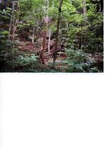
Odd know one has mentioned the arrow on the map. Following the first map off of tea kettle rock, we were able to find the rockhouse and were a furnace had been in another rockhouse. that one part of the journal that states, 100 yards above the rockhouse? well there is another rockhouse and it had a furnace in it at one time. the roof is pitch black from fire. On the outside, the hill is vary steep down to the creek. The rock from the fernace was thrown there. There was another map and a Turkey track pointing west. anyway on the swift map it shows 4 caves side by side with a dot under each one. About 5 miles away heading west, we found four caves and they are about 3 to 6 hundred yards apart. This photo shows what was there. Look close at the rock in center of picture and you will see an arrow pointing to a cave in the upper right hand corner. Inside on the right is a place that is backfilled with dirt and rock. This is going to be hot dirty work. But i don,t care whats in there, i have more fun trying to figure out the mystery. On tea kettle rock there is another map that looks like the map in hensons book called lower devils creek. but its hard to make out.
t
t