Ki, Blackburn and Company

boomer

Sr. Member
Jul 8, 2003
487
523
kentucky
Detector(s) used
army all terrain
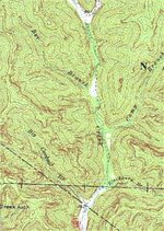
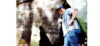
This map shows where blackburn 's name and grave are. just above this hollow is where an ancient camp was found. One date 176? 7 or 9 not sure.
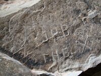
go up spa's creek about a 1/2 mile near the head is where the old grave is. the road up this creek was pasable. several carvings. I got this from the sperlock family in johnson county.

Everyone talks about the great cave of the Shawnee. But the true is it was made this way later on, in the original journal it was an indian cave.
Talking with several Cherokee elders in 96. They said that the only big battle was in West Va. or Va. Look up rich mountain. there are several caves around this mountain.

1768s
- Patrick Henry comes to S.W. Va. to acquire land along the Clinch River.
He fails to find his 3000 acre survey (mistakenly looked for the Moccasin Cr.
entrance to the Clinch, which it doesn't) Spent some time at Long Island .
- Great Battle between 200 Cherokee and several hundred Shawnees at
Rich Mountain. (over hunting rights)
 

Attachments

  • Spaa creek red river.jpg
    Spaa creek red river.jpg
    62.3 KB · Views: 839

-Ki-

Hero Member
Feb 12, 2009
642
574
EASTERN KENTUCKY
Detector(s) used
MD & Handwand "CaveHunter"Hiker" SonyDigital SLR
Boomer,
Thanks!!! I've heard of Spa's creek! I live kinda close to it... Have you gotten any pics of these places yet?
 

OP
OP
boomer

boomer

Sr. Member
Jul 8, 2003
487
523
kentucky
Detector(s) used
army all terrain
Ki, did not have camera with me. i did see seven carvings. but the odd one was done in backword letters SLGIVVV NN. With an arrow pointing up and a cross on top. have tried to figure this out. keep thinking that the arrow means north. but it may mean down or go in the other direction to a cross or go left or right. i do know the road up spa creek goes north and this was an old trail it tied in with the buffalo trace that is rt. 460 now. as for tea kettle, we used a back hoe to make a road up to the rockhouse and had to clear about 12 to 16 inches to get down to the sandy floor. this place must have been used for hundreds of years by the indians. 2 of the ladies have been sifting and have dug holes down 3 feet and they are still finding arrow heads, cutting tools. when we go back there this summer, if anyone wants to go along let me know.
 

-Ki-

Hero Member
Feb 12, 2009
642
574
EASTERN KENTUCKY
Detector(s) used
MD & Handwand "CaveHunter"Hiker" SonyDigital SLR
Yeah anytime you wanna go back up there just let me know, i'll tag along. Id say there some good rockhouses up there, Have you ever had a MD up there?
 

-Ki-

Hero Member
Feb 12, 2009
642
574
EASTERN KENTUCKY
Detector(s) used
MD & Handwand "CaveHunter"Hiker" SonyDigital SLR
The NN could mean "north northeast" :icon_scratch:
Thinking of what kind of trail marker it could be, which way is the arrow pointing.... could also be pointing to another marker, there could have been a tree marked, or another rock, or cliff carving somewhere...

Let me know when you go back, sounds like a great place to photogragh...... :thumbsup: :coffee2:
 

OP
OP
boomer

boomer

Sr. Member
Jul 8, 2003
487
523
kentucky
Detector(s) used
army all terrain
this has me stumped, why go to all the trouble to put the letters this way. after all if this was a main camp for someone, you would all ready know which way to go. looking at the way the V's are placed. it could be saying find 2 knobs or 2 mountain tops that come to a point? in a north, north east direction. who knows. i did not spend much time there as it was almost dark. a topo map should find the the 2 knobs if that is what it means.
 

Rebel - KGC

Gold Member
Jun 15, 2007
21,680
14,739
:coffee2: :tongue3: :thumbsup: "V" Usually means a VALLEY; MAY have a VALLEY in between two mountain ridges... DUNNO.
AND! A "church" on the mountaintop somewhere? IF... there was a "camp" there, COULD be CSA; IF... there was a "castle" there... COULD be KGC. SPAA Creek on RED River, eh? I think it was BOTH! :wink:
 

Rebel - KGC

Gold Member
Jun 15, 2007
21,680
14,739
:coffee2: :tongue3: :thumbsup: As a "follow-up" to the "above". IF... the RED RIVER was in the "pan-handle" of TEXAS; it DOES "fork" & "rise up", AND! TEXAS was a HOTBED of CSA REBELS, KGC, and OUTLAWS, after the "Civil War". NOT sure about mountains, tho... :icon_study: ???
 

Rebel - KGC

Gold Member
Jun 15, 2007
21,680
14,739
:icon_study: There IS a Johnson County in TEXAS; list of rivers in Virginia @ http://en.wikipedia.org/wiki/List_of_rivers_in_Virginia :wink: Isn't there a Johnson county in Tennessee; NONE in Virginia, as far as I know... :icon_study: ??? YEP! In Tennessee... Johnson County & RED RIVER @ http://en.wikipedia.org/wiki/Red_River(Tennessee-Kentucky) :wink: :coffee2: :tongue3: :thumbsup: HA! I just had it... NOW.. it is GONE! ??? Just "google" LIST OF RIVERS IN TENNESSEE :wink:
 

swiftsearcher

Sr. Member
Feb 25, 2006
443
71
VA
Detector(s) used
MP 3 Pro Digital
Primary Interest:
All Treasure Hunting
True - Swift stated it was an "Indian Cave" in one early journal and in another stated the cave as the "Great Cave". TBH, the FIRST person to ever publish it as being the "Great Shawnee Cave" was Henson. I believe he either added this to a journal (as he added Swift's signature to one in one of his books) or someone before him added "The Great Shawnee Cave".

Anyway, I have an old map that shows the location in relation to Swfit's mines and will probably start out looking for it next week. I should have already found it, but stumbled across a large KGC depository and have spent my time opening it instead.
 

-Ki-

Hero Member
Feb 12, 2009
642
574
EASTERN KENTUCKY
Detector(s) used
MD & Handwand "CaveHunter"Hiker" SonyDigital SLR
Boomer,
The carving SLGIVVV NN, could mean "SL= silver GI= gold VVV= mine, or place where hid or cached, NN= a north northeast direction, seeing a picture would help more than anything trying to unlock this carving... this still has me puzzled as well :icon_scratch: -Ki-
 

OP
OP
boomer

boomer

Sr. Member
Jul 8, 2003
487
523
kentucky
Detector(s) used
army all terrain
KI, this has me going around in circles, one day aahaa i'v got it, than a little later something else comes along and you start all over again. because it was getting dark ahhh, i should have gone back the next day and cleaned the other rocks. but come june 1 i will stop there and see what i can find.
 

-Ki-

Hero Member
Feb 12, 2009
642
574
EASTERN KENTUCKY
Detector(s) used
MD & Handwand "CaveHunter"Hiker" SonyDigital SLR
your carving of SLGIVVV NN could be the same as my carving ^ ^^

Im thinking its maybe knobs or mountains, it could be saying look for single knob, then go through gap, to twin knobs with a saddle (gap). There is the same looking knobs here, a single knob gap and twin knobs, and there somewhat close to my site. On the twin knobs my cousin was hunting a couple falls ago and found a cave. He said he threw a rock back in it and heard something hiss at him, like a mountain lion or bobcat. Im gonna look for this cave this winter, hopefully it wont be to hard to find?? -Ki-
 

-Ki-

Hero Member
Feb 12, 2009
642
574
EASTERN KENTUCKY
Detector(s) used
MD & Handwand "CaveHunter"Hiker" SonyDigital SLR
Just to bring back up Blackburns grave, i found this in a great book called "The Kentucky". It has a chapter in it about the swift mines, and even tells about the person that found gold in tight hollow. Its a must read for the serious swift hunter.... Here is a small paragragh.....
 

Attachments

  • 09-28-09 016.jpg
    09-28-09 016.jpg
    63.1 KB · Views: 581
OP
OP
boomer

boomer

Sr. Member
Jul 8, 2003
487
523
kentucky
Detector(s) used
army all terrain
Tight Hollow: Before i started keeping notes and making copies on all this stuff, the old library at west liberty had a book something like (mysteries of the cliff country)?? it told of buttons, money molds and mining tools being found in a small rockhouse on mill creek. the rockhouse is on the right side before tight hollow, there was a small furnace next to the creek. i'm guessing the lake has covered it up. from what i remember, the gold was vary fine and had washed down near the mouth of tight hollow. back then they had paddle boats you could use on the lake, i should have rented one but ahh never did. maybe they still have them. but in those days the old bfo detectors were all we had. not sure, but i think henson had mill creek in one of his books.
 

-Ki-

Hero Member
Feb 12, 2009
642
574
EASTERN KENTUCKY
Detector(s) used
MD & Handwand "CaveHunter"Hiker" SonyDigital SLR
Tight Hollow, Wolfe Co --- 1937 Jim Rose son of Clint Rose found a huge lump of Gold assayed 85% gold 15% silver..... In the languge of the region here was "pyore" gold and silver worth, so it is said, $950,000 a ton back in them days.... But the find was real, there is gold and silver in the hills and mountains of Ky. -Ki-

By building the Mill Creek dam, and flooding the area would be a good way of the state hiding something important like a silver mine... Heck they was wanting to dam up the entire Red river gorge about 30 years ago....Im so very happy and blessed they didnt.... :thumbsup:
 

-Ki-

Hero Member
Feb 12, 2009
642
574
EASTERN KENTUCKY
Detector(s) used
MD & Handwand "CaveHunter"Hiker" SonyDigital SLR
swifthistoryman, thats a great pic............ :icon_thumright: & thank you for posting the pic.....
 

-Ki-

Hero Member
Feb 12, 2009
642
574
EASTERN KENTUCKY
Detector(s) used
MD & Handwand "CaveHunter"Hiker" SonyDigital SLR
The Skull & CrossBone....
In Mike steelys book "Swift Silver Mines & related appalachian treasures" he throws out some points on Blackburn.
Blackburn was an original crew member, his christian name was givin as J.C., john, samuel, and even Hans...
 

Attachments

  • MINE hike 012.JPG
    MINE hike 012.JPG
    111.3 KB · Views: 532

Top Member Reactions

Users who are viewing this thread

Latest Discussions

Top