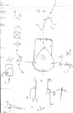
1. This as to do with the post and photo that i put in on the Tea Kettle Rock. The first picture is a drawing i made of the way the carvings or set on the top, sides and back. I always do drawings at the site, so there will be no mistake on how the carvings or laid out. Tea Kettle is in the center and your looking down at the rock. I put arrows pointing to where each carving is on tea kettle. On the lower left you will see a (1.) this is the carving that is on top of a large rock about 50 feet away and about 15 feet above tea kettle on the side of a hill. Standing at this carving, you are looking down on tea kettle. The door part is telling you to look at the carvings on this side of the tea kettle. Also there is a line cut at an angle and it points 330 degrees. Using a topo map we found that it points to
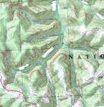
a part of the high ridge about 2 miles away, see carving (4.). The carving on your left is the main carving to get to the rockhouse they used. The (X I I I) is the same as on swifts map. Look at the square with an X going to each corner, just add it to the (X I I I). this is a flat rock on top of the ridge that was cut square . its about 12" thick and 6x6 feet. on swifts map it shows 2 lines down the center. could it mean a shaft under? I put in a part of the topo map showing the place where tea kettle is. The small circle. Look at number (2.) at the bottom. The (W) is on the topo just above tea kettle. The line runs across the ridge and the end points to a large rockhouse about 3 miles away on another creek. The sword is a ridge line shaped that way and about 1/2 mile past the tip is a place where the mountain at one time crashed in on its self and formed a sink. Its like standing inside a volcano.
Swifts map: Look at the topo and on the left side of tea kettle you will see that the creek going towards the head is shaped like an anchor and where the rope would be tied is tea kettle. On swifts map is a bell, there are 2. One is a high knob shaped like a bell and then this one on the topo. the right fork forms a bell.
Lime Stone Cliff: This topo shows the cliff that is limestone layers as on swifts map with a trail going up and turning right. notice the rockhouse near the cliff. I stood on the ridge and with my binoculars looked across and could see what may have been a furnace.
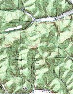
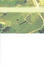
Sink Hole: On swifts map it shows a wagon wheel or better known as a sink hole of some type. I saw this sink about 1987 and of course i just drove past, it was about 20 feet deep and 40 feet round. Well last year i tried to find it, no luck. Well i asked and found out that a new road had been put in and the sink was filled up. anyway here is a photo of the sink.
a part of the high ridge about 2 miles away, see carving (4.). The carving on your left is the main carving to get to the rockhouse they used. The (X I I I) is the same as on swifts map. Look at the square with an X going to each corner, just add it to the (X I I I). this is a flat rock on top of the ridge that was cut square . its about 12" thick and 6x6 feet. on swifts map it shows 2 lines down the center. could it mean a shaft under? I put in a part of the topo map showing the place where tea kettle is. The small circle. Look at number (2.) at the bottom. The (W) is on the topo just above tea kettle. The line runs across the ridge and the end points to a large rockhouse about 3 miles away on another creek. The sword is a ridge line shaped that way and about 1/2 mile past the tip is a place where the mountain at one time crashed in on its self and formed a sink. Its like standing inside a volcano.
Swifts map: Look at the topo and on the left side of tea kettle you will see that the creek going towards the head is shaped like an anchor and where the rope would be tied is tea kettle. On swifts map is a bell, there are 2. One is a high knob shaped like a bell and then this one on the topo. the right fork forms a bell.
Lime Stone Cliff: This topo shows the cliff that is limestone layers as on swifts map with a trail going up and turning right. notice the rockhouse near the cliff. I stood on the ridge and with my binoculars looked across and could see what may have been a furnace.
Sink Hole: On swifts map it shows a wagon wheel or better known as a sink hole of some type. I saw this sink about 1987 and of course i just drove past, it was about 20 feet deep and 40 feet round. Well last year i tried to find it, no luck. Well i asked and found out that a new road had been put in and the sink was filled up. anyway here is a photo of the sink.