Need some Help with this map

boomer

Sr. Member
Jul 8, 2003
487
523
kentucky
Detector(s) used
army all terrain
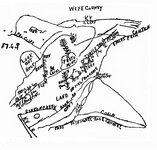
LOWER DEVILES CREEK MAP: This is a map that is correct, but at sometime long long ago someone added things to the map. I guess they figured it was lower devils creek and that it was swifts. Later on, others got hold of the map and the rush was on. Back when henson's book came out, myself and 2 others went to lower devils creek. Standing on the the top of the cliff and looking down at the creek, it looked like a war zone, i never saw so many holes. We found 2 of the carvings on sandstone rocks, but the edges were vary sharp not like something done 200 years ago. Talking with one farmer, he said that several iron kettles were found in the gorge in a rockhouse, just like in Hensons book. About 2 years later i was reading the story of Boonesboro and found that they worked a salt lick on lower devils creek and used iron kettles in the salt operation.
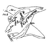
Now, the first map is what has been passed around for years. The second map, what i did was take all the writing out that was added to it and kept only what i feel may have been on the original, I left the KY R in because that part is correct, who ever put that in was right on that.
Looking at the second map: top left where it shows the cave. all around it there are 8 dots. thats my problem, what could they mean?
: top right look at the Turkey track. there is a creek that has 3 forks and has cliffs on both sides. why? is there anything telling something being
something being at the three forks?
I was thinking that this could be a treasure net forum project and during the summer you guys and gals could work on this. Myself with knee surgery. it will be awhile before i can do anything. Later this week, I'll have the correct creeks named and put in the forum. The one thing that is a plus is that everyone has been looking in the wrong place.
 

Attachments

  • 1. Original Map - Lower Devils Creek.jpg
    1. Original Map - Lower Devils Creek.jpg
    245.3 KB · Views: 2,076
  • Before add on\'s.jpg
    Before add on\'s.jpg
    59.3 KB · Views: 850

Rebel - KGC

Gold Member
Jun 15, 2007
21,680
14,739
;D :coffee2: :tongue3: :thumbsup: In "treasure-lore", when you have a "Turkey Track"... you look, or go in the direction of the LONGEST, MIDDLE TOE. It is either gonna "direct" you to the "treasure"; OR... the NEXT "clue". Good Luck... HH!! :wink: :icon_sunny: 8)
 

swiftfan

Sr. Member
Feb 24, 2008
353
491
Pikeville, Ky
Detector(s) used
Garrett Ace 250
Primary Interest:
Other
That's a map I haven't seen yet... the turkey track points to the cave. The cave was mentioned as a storehouse. Has this cave been found? if so, by whom, and when. Also, the center says 15 feet to mine. Which direction? Could it be 15 feet underground? Something to think about. Anyway, I'll check it with what I have to see if I can come up with anything.

Sorry bout the knee, get better soon...

Swiftfan
 

Rebel - KGC

Gold Member
Jun 15, 2007
21,680
14,739
:coffee2: :tongue3: :thumbsup: Hmmmmm... looks MORE like a cedar tree growing out of a rock; seen MANY like that around here. ??? Will check 'em out CLOSER, next time... :wink: 8)
 

Swifty

Full Member
Aug 13, 2007
125
68
Kentucky
Detector(s) used
Whites XLT (E- Series)
Primary Interest:
All Treasure Hunting
Hello all
That map is the Kelly Dunn map or Griffith map as I have heard it called, I call it the Kelly Dunn map, I have had a copy of it for over 10 years. I know a place were that map fits perfectly and it ain't on Lower Devils creek were people say it was found. The problem I have with the map is this: I don't think it refers to the old shawnee indian cave Swift says he stored his wealth in. It does show a lookout rock and a cave up in a mountain 90 poles from the rock with the MF on it, with a creek cave below and a mine at land level by a turtle or bell shaped rock with a tree on it, but if I'm correct about the location of the old shawnee cave that map ain't it. To me it is a map of some cave maybe someones stash cave with a mine below it, the only thing to me that is familiar about the map being associated with the swift mines is the date 176f, the turtle/bell shaped rock and a lookout rock and the word Sinkon Creek, I hear if you fold the map in a certain way it yields other information. But I could be wrong about my assumptions just my opinion, it very well could be the old shawnee indian cave because I have not checked the spot yet, I have other research that tells me differintly.


L37something

L37something
 

-Ki-

Hero Member
Feb 12, 2009
642
574
EASTERN KENTUCKY
Detector(s) used
MD & Handwand "CaveHunter"Hiker" SonyDigital SLR
Hey boomer, L37, rebel, and everyone..... What one must remember with lower, and also upper devil's creek is that this place was well known and searched well for the last 250 plus years. People whom first searched this place was Daniel Boone, John Filson, James Harrod, John Finley, Michael Stoner, and many more from Swifts era. All these men knew Swift and or Swifts mines...
for one think of the endless time these men had to search for the mines, thats all they had back then was time. And plus Swifts mines would be well more hid today than they was back then, i mean with all the trails Swifts pack animals made, they would have been easy to spot being that freshly cut, and worn....just something to consider! Then you had poor ms becky timmons, this poor lady searched endlessly for the mines in this area of the swift lore, even both upper and lower devil's creek...she even hired help. If the mines or cave was in this area, it would have been found id think. but who's to say all these people may have over looked something, or even hid something better than Swift did.... -Ki-
 

-Ki-

Hero Member
Feb 12, 2009
642
574
EASTERN KENTUCKY
Detector(s) used
MD & Handwand "CaveHunter"Hiker" SonyDigital SLR
Here is a story id had about upper devil's creek, not sure if its the same devil's creek but still pretty cool............ -Ki-


By Amy Wilson - HERALD-LEADER.COM

Worley Charles’ grandfather told the story of when, as a boy, he marked timber somewhere along the Licking River and then rode the logs down the river. Somewhere along upper Devil’s Creek, 12 feet up on the ridge, he saw a hole in the ledge.

He climbed out of the water, cut a pine tree into a ladder and made his way up to look inside.

There, he found a set of hinged money molds in a bundle of leather. He had heard many times the story of Kentucky’s lost silver treasure, and how a man named John Swift had found or hid or smelted thousands in glistening nuggets and coins somewhere in these woods named now for Daniel Boone. But the man who hid the vast cache had gone blind. Blind!

Superstitious, Worley Charles’ grandfather never went back for more.

But his grandchild Worley was not so easily scared. He has been looking for John Swift’s silver since he started reading the copies of the 40 different Swift journals he’s gotten his hands on. He’s been looking for 35 years.
 

swiftsearcher

Sr. Member
Feb 25, 2006
443
71
VA
Detector(s) used
MP 3 Pro Digital
Primary Interest:
All Treasure Hunting
Without looking through my books, I believe this map was printed in one of Henson's books. It is NOT related to Swift or Swift's mines, but is interesting and might point to something of value!
 

swiftfan

Sr. Member
Feb 24, 2008
353
491
Pikeville, Ky
Detector(s) used
Garrett Ace 250
Primary Interest:
Other
Hey guys, I haven't been on Lower Devil's creek, but my interpretation of the map is that from the mouth at (or near) the river, there should be a marker stone on the right. Look for a mark on the stone. This would be a surveyor's mark. From there, 90 poles would be the next marker.From this point is where they would have set the center. From here, you should be able to line up the other points on the map. There looks like another reference point in between the pole and the marker stone. From there, it shows what could be a small drain coming down.
The lookout rock is just that, where the lookout would post, keeping a sharp eye out for the curious, who would disturb any goings on there. Also the dots may indicate a trail, or path, leading by the cave.

Now, here's something.. The rock in the center appears to have marks on it, and the general shape appears to point to the "mine"? , or within 15feet to the mine? (could this be the Teakettle Rock?)

From the later map, The Turtle trail goes through the area, with other marks there I can't really make any sense of yet.

The turkey track appears to be at the head of the hollow, pointing towards the cave. Now, if you draw a line, the marker rock, the cave, and the turkey track make a triangle. Placing the "mine" at the center. This is how they could have used these markers to find the mine later, as they would have hidden the opening to find later. by using the map in the same way, it should help you to really narrow your search. I would also take a MD along once the area is found.

Like I said, I have never been there, but this is how I see the map. Hope this helps in some way.

swiftfan
 

Top Member Reactions

Users who are viewing this thread

Latest Discussions

Top