Swift in Northeastern KY.?

The_Frontiersman

Jr. Member
May 22, 2009
78
59
Eastern Kentucky
Detector(s) used
Garret Ace - 250
Primary Interest:
Other
Hey Everyone..

I live in Ashland, Kentucky, on the Boyd, Carter County line. I've read some on a few mines and discoveries around Carter County, and Carter Caves. I live up the road from the caves and have been hunting around the area for some time now. Just wondering if any of you guys have any information on the areas of Carter, Boyd Counties... or Louisa, Paintsville, [etc.]. Any new or old info would be greatly appreciated.

Thanks ,
Casey " The_Frontiersman"
 

snake35

Hero Member
Jul 25, 2005
918
25
West Virginia
I prospected the Louisa area pretty hard a few years ago. Not much luck, but I heard lots of rumors from the Paintsville area. Good luck!
 

boomer

Sr. Member
Jul 8, 2003
487
523
kentucky
Detector(s) used
army all terrain
this is all from memory.
Carter Caves State Park: at bat cave just in front where the dry creek makes a U turn, i found some burned rock, i put it in a reheat furnace at work and 4 small drops of silver came out. Pollocks jewelers said it was pure. behind the Lodge where the lake is, i think the place is known as smokey valley. 2 silver bars were found and also a money mold. the road that goes past carter caves and runs into the road that you can turn right and go to carter city. the last hollow on your right just before the intersection. there is an old silver mine about half way up the drain. by the way, this was all shown on an old county map about 1900/1910?
Carter City: same map, at carter city near the cross roads is an old sandstone school. across the road from the school and up on top of the cliff was a silver mine. i looked at topo and aerial photos of the top of this cliff and it showed an old trail that dead ended at a hill on top of this cliff.
Town of Greenup : in the vary early days this town was called greenupsburg and Daniel Boone's son or grandson he was the high sheriff. boone and several men went to where carter caves is and arrested several men who were making counterfeit dollars. look in one of paul hensons books on kentucky for the rest on carter county.
Fort Gay and louisa: at the forks of sandy vary near the bridge on the fort gay side about 2 hundred yards below the bridge
there is a small drain. at the end there are some faint carvings with js, ab, and sb, and a hole where something as been dug out. there is silver in carter county. good luck
 

Rebel - KGC

Gold Member
Jun 15, 2007
21,680
14,739
Wasn't that area part of OLD Virginia...? MAYBE some info is available in OLD Virginia folders SOMEWHERE!
 

franklin

Gold Member
Jun 1, 2012
5,036
7,168
Detector(s) used
Garrett ADS-7X, Fisher Two Box M-Scope, Mother Lode Locator, Dowsing Model 20 Electroscope, White's TM808, White's TM900, Inground Scanners
Primary Interest:
All Treasure Hunting
I would love to see what is written in the Draper Manuscripts. No one has put these records into book form. There is a reference book to what is contained in the manuscripts but nothing with the actual words and works of the manuscripts. To view these manuscripts you have to go to Minnesota. There are several references in these manuscripts about Swift and his Silver mines. The old newspapers of early Kentucky I have found informative because they give the areas settled, the landowners and where families lived. Someone needs to take these newspapers and map the time and locations of different families in Kentucky. I would certainly purchase them just for a reference book.
 

KY Hiker

Bronze Member
Oct 28, 2014
1,537
3,220
North Central Kentucky
Detector(s) used
Whites
Primary Interest:
All Treasure Hunting
That would be a huge effort to cross reference and get into one text, some of the creeks names have changed and those were many times the 'property' lines. Names have changed spelling often as well too. I still think, for example, the Guest name so often tied to Swift is actually the Gist who was the explorer/surveyor. Probably due to the first stories told around the fire in early KY got merged over time.
 

franklin

Gold Member
Jun 1, 2012
5,036
7,168
Detector(s) used
Garrett ADS-7X, Fisher Two Box M-Scope, Mother Lode Locator, Dowsing Model 20 Electroscope, White's TM808, White's TM900, Inground Scanners
Primary Interest:
All Treasure Hunting
Yes, the Gist was Nathaniel Guest that married an Indian. He lived at Walnut Cove, North Carolina and had property up towards Nettles, Maryland which is Cumberland, Maryland today. His father was Christopher Guest that made an exploratory trip into Kentucky in the 1740's and mentioned a wall of burnished brass if this be gold it is the richest he had ever seen. And this was near Boonesborough, Kentucky. Guest and Boone had an argument at the Cumberland Gap. Guest went his way and Boone went his. The argument could have been over Guest trying to recruit Boone into the Swift Group?

I believe that Governor of North Carolina just before the Civil War was his son?
 

Ken S.

Hero Member
Oct 1, 2018
577
1,615
Paintsville,Ky.
Primary Interest:
Other
Wasn't that area part of OLD Virginia...? MAYBE some info is available in OLD Virginia folders SOMEWHERE!

From some of the old maps I've seen the complete state of Ky. was part of old Va. Don't remember which maps it was but pretty sure this is the case.
 

KY Hiker

Bronze Member
Oct 28, 2014
1,537
3,220
North Central Kentucky
Detector(s) used
Whites
Primary Interest:
All Treasure Hunting
I think I have seen maps like that, I think the lines ran straight West to the Mississippi River. That map would show VA. as a colony and not as a state. Almost all of what would become KY was French claimed at that time though.

http://etc.usf.edu/maps/pages/2600/2684/2684.htm

http://etc.usf.edu/maps/pages/6600/6642/6642.htm

http://etc.usf.edu/maps/pages/3800/3870/3870.htm

http://etc.usf.edu/maps/pages/7700/7701/7701.htm

Chiswell's mine on this next one..
http://etc.usf.edu/maps/pages/2400/2421/2421.htm

https://en.wikipedia.org/wiki/John_Chiswell
 

Last edited:

franklin

Gold Member
Jun 1, 2012
5,036
7,168
Detector(s) used
Garrett ADS-7X, Fisher Two Box M-Scope, Mother Lode Locator, Dowsing Model 20 Electroscope, White's TM808, White's TM900, Inground Scanners
Primary Interest:
All Treasure Hunting
It was part of Botetourt County, Virginia and at one time before Statehood it was called State of Franklin for Benjamin Franklin. Because B.Franklin and the Transylvania Company owned all of Kentucky, Parts of Indiana, Ohio and Pennsylvania. They were given the land by the King of England because of a trading post the Indians burned in Pennsylvania. That is how they all got rich from the sell of the land of millions of acres.
 

KY Hiker

Bronze Member
Oct 28, 2014
1,537
3,220
North Central Kentucky
Detector(s) used
Whites
Primary Interest:
All Treasure Hunting
This is one of the maps I've seen

https://s3.amazonaws.com/carolinajournal.com/app/uploads/2016/06/16075908/colonies-1024x742.jpg


by this map Va. took in the area of what is now W. Va. Ky. Ohio and Indiana

I wonder why this map is so much different than most of that time. Virginia claims beyond the Mississippi river is ridiculous. That would tick off the French and the Spanish. Most likely an act of war if they would have seen it. That wouldn't be claimed until Jefferson was President, part of the LA. Purchase of 1803.

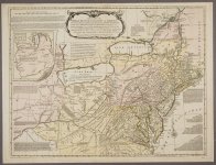
Here is a contemporary map for Swift 1768.
1768BritishColoniesPrinted for John Bowles.jpeg
 

Last edited:

Top Member Reactions

Users who are viewing this thread

Top