Lower Devils Creek (Research) Part 2

boomer

Sr. Member
Jul 8, 2003
487
523
kentucky
Detector(s) used
army all terrain
Research on this was done by driving around the area one day and taking photo's. 2 day's working with a 3D topo mapping system and google earth 3D program. Its a lot easier, than running around the hills wasting time. Think of all the time wasted at lower devils creek. Wrong info on a map can make for a bad day. There is one thing, (Cave Branch). It was a vary sacred place to the shawnee nation, Home to the ancient ones. This place needs to be checked vary closely. Has far as the writing on the map, someone added most of whats on the map, if not all?? This map is on tea kettle rock and take note of all the V's on the map. cache sites?? Anyway i'd love to be in on this, but knee says no. If anyone works on this, let me know how you do. good luck.

See maps below locations.
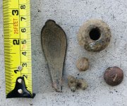
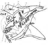
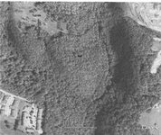
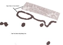
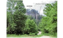
1. Beattyville Kentucky. 2. Crystal Creek (Indian trail went along this creek up to RT. 11 going to Natural Bridge area). 3. Silver Creek (Crowns and 2 silver bars found on lower part of creek 1812). 4. See photo. (On west side of Crystal Creek, hill shaped like a bell with a drain on west end of hill. just before 3 mile branch. (Notice that the drain is exaggerated. Why??). Mine, Cache site or Camp. 15 feeto mine from what??). 5. North fork Kentucky River 6. Miller Creek (About 4 miles west of Beattyville, north side of Kentucky River. Notice dots at mouth of creek) Cache/Caves??. 7. This is 3 mile branch on crystal Creek. (Notice the flag pole, the head is next to the creek, may mean a mine shaft??). 8. See Photo. (Across from bell on east side of crystal Creek is a ridge that matches the odd shape on the map. South side of ridge shows a sugar tree, its a drain exaggerated). why??. 9. Cave Branch. See Photo. (This is located on the headwaters of Big Sinking Creek. Its a level area on the branch, the dots may be caves in area or cache sites, there base camp location??). Sorry 11. Look Out Rock. (Its a high knob located between the first forks of Silver Creek. good place to watch from or something buried there. Pointer Rocks??). 10. Turkey Foot. (Located on the headwaters of Billey Fork of miller Creek. known locally has 3 forks branch with ridges both sides. Why exaggerated??). 12. Sink or Pond west side of Crystal creek. (This has vary small drains running in to it from all sides. Located between item 13/14. why show it??). 13. Rock. ( Its a large round hill on the east side of Crystal Creek just past the mouth. Shows maybe a cave or rock with carvings on it or something buried there??). 14. Deep Drain Crystal Creek. (There is a pool of water that the creek flows thru it. Something up drain??). 15. Bald Rock. Silver/Crystal Creeks.(At the end, the two branches come back toward each other. There is a large flat rock known as Bald Rock on top of the ridge. Shows cave or cache site across creek. carvings maybe??). 16. Big Sinking Creek. Soth branch of Miller Creek. 17. Billey Creek north branch of Miller Creek.
 

Attachments

  • 3. Map Mod. - Silver & Crystal Creek not Devils creek.jpg
    3. Map Mod. - Silver & Crystal Creek not Devils creek.jpg
    153.5 KB · Views: 1,499
  • Bell number 2.jpg
    Bell number 2.jpg
    51.3 KB · Views: 1,161
  • Cave Fork Branch.jpg
    Cave Fork Branch.jpg
    20.4 KB · Views: 1,179

-Ki-

Hero Member
Feb 12, 2009
642
574
EASTERN KENTUCKY
Detector(s) used
MD & Handwand "CaveHunter"Hiker" SonyDigital SLR
Re: Lower Devils Creek (Research) more important than biscuits & gravy

Boomer,
Thats awesome map research! I see you have mentioned billey fork, do you know about townsend cave? I wonder if it might tie into the swift ledgend, or even indian, im sure the indians would have known about it. The cave is huge. My family has ties to the cave going back to the mid 1800's.
On the map of devils creek, it mentions a turtle trail. I wonder if that trail might tie together with the sheltowee trace. Sheltowee means turtle in indian. The sheltowee trace is very very close to upper and lower devils creek. Just a thought. thanks and talk to ya soon -Ki-
 

OP
OP
boomer

boomer

Sr. Member
Jul 8, 2003
487
523
kentucky
Detector(s) used
army all terrain
Re: Lower Devils Creek (Research) more important than biscuits & gravy

ki, The old Indian trail ran from the mouth of Crystal creek on the left side, next to the creek to 3 mile branch to the head, then north along RT. 11 passing by natural bridge state park. Aerial map shows this old trail next to the creek. The cave you talk about was not on the map and i no nothing about it. But?? on the map, could the Turkey track or 3 fork branch marker point towards that cave. that marker is there for a definite reason. That cave does need checking out. I feel that old miners would hide stuff in small caves easy to cover up. but?? if a large cave had a small branch, then i guess they could cover the opening and make it look like no branch was ever there. Now is when the leg work begins. The V's on the map have me wondering. Could they be vary small sunken places, drop something in and cover it up or small openings on a hill side and cover it up. locations of rocks that have carvings that point to something or something under said rock. one thing i learned long ago, if searching an area, check both sides of flat rocks or unusual rocks.
 

-Ki-

Hero Member
Feb 12, 2009
642
574
EASTERN KENTUCKY
Detector(s) used
MD & Handwand "CaveHunter"Hiker" SonyDigital SLR
Re: Lower Devils Creek (Research) more important than biscuits & gravy

boomer said:
ki, The old Indian trail ran from the mouth of Crystal creek on the left side, next to the creek to 3 mile branch to the head, then north along RT. 11 passing by natural bridge state park. Aerial map shows this old trail next to the creek. The cave you talk about was not on the map and i no nothing about it. But?? on the map, could the Turkey track or 3 fork branch marker point towards that cave. that marker is there for a definite reason. That cave does need checking out. I feel that old miners would hide stuff in small caves easy to cover up. but?? if a large cave had a small branch, then i guess they could cover the opening and make it look like no branch was ever there. Now is when the leg work begins. The V's on the map have me wondering. Could they be vary small sunken places, drop something in and cover it up or small openings on a hill side and cover it up. locations of rocks that have carvings that point to something or something under said rock. one thing i learned long ago, if searching an area, check both sides of flat rocks or unusual rocks.

Boomer,
Yes i agree, the cave would be perfect to MD, my kinfolk many years ago lived in the cave. This was the early 1800's to mid 1800's. My mother has a family book of the people whom lived there. Im waiting to get ahold of it next, as of the moment my aunt has it. The cave is located on the Lee and Estill county line north where the boundry starts turning south. I think after their cabin was built they used the cave as a natural barn, keeping there livestock cool and sheltored. I think the arrows on the map above are pointers, go in that direction. Maybe to another pointer or marker? I have seen some of the same symbols that are on the map carved in rock on certain cliftlines i know of around the spot of the mine i located. Some symbols could be carvings, blazed trees, or trail marker, would love to know.....
 

-Ki-

Hero Member
Feb 12, 2009
642
574
EASTERN KENTUCKY
Detector(s) used
MD & Handwand "CaveHunter"Hiker" SonyDigital SLR
Re: Lower Devils Creek (Research) more important than biscuits & gravy

boomer said:
ki, The old Indian trail ran from the mouth of Crystal creek on the left side, next to the creek to 3 mile branch to the head, then north along RT. 11 passing by natural bridge state park. Aerial map shows this old trail next to the creek. The cave you talk about was not on the map and i no nothing about it. But?? on the map, could the Turkey track or 3 fork branch marker point towards that cave. that marker is there for a definite reason. That cave does need checking out. I feel that old miners would hide stuff in small caves easy to cover up. but?? if a large cave had a small branch, then i guess they could cover the opening and make it look like no branch was ever there. Now is when the leg work begins. The V's on the map have me wondering. Could they be vary small sunken places, drop something in and cover it up or small openings on a hill side and cover it up. locations of rocks that have carvings that point to something or something under said rock. one thing i learned long ago, if searching an area, check both sides of flat rocks or unusual rocks.
Boomer was you refering to the "sheltowee or warriors path"? thanks -Ki-
 

OP
OP
boomer

boomer

Sr. Member
Jul 8, 2003
487
523
kentucky
Detector(s) used
army all terrain
Interesting what pops up out of the clear blue. this was sent to me and it adds a little more to the map of beattyville and the big sinking creek area. the first photo is on cave branch of big sinking. this area was clear cut in the 1920's and shows the top of the ridge well. it was known has hay stack rock. before the tree cutting all you could see was the dome or the hay stack shaped rock.
next to the rock symbols were found that were thought to be spanish. But his grandfather who liked early kentucky history could not find anything that matched the spanish, english or the french explorers. big sinking and cave branch was a sacred place to the shawnee tribe. photo 2 shows a leaning or a large section of rock that has separated from the ridge, this was called chimney or balanced rock, because it is smaller at the bottom then the top, between the ridge and the rock in the gap there are turkey tracks and numbers. where the two pointers are, more symbols and initials.
 

Attachments

  • hay stack rock big sinking creek lee county.jpg
    hay stack rock big sinking creek lee county.jpg
    139.4 KB · Views: 1,019
  • Chimney or Balence rock lee county.jpg
    Chimney or Balence rock lee county.jpg
    94.6 KB · Views: 973

Curtis

Hero Member
Sep 3, 2008
898
1,008
Cincinnati
Primary Interest:
All Treasure Hunting
Hi Guys,

Could any of those squiggly lines be ridge lines? The lookout rock kind of looks like it might be on a ridge? But if it fits a map and that is a creek then it looks like someone could find the mine from the look out rock. Interesting stuff! Very interesting!
 

-Ki-

Hero Member
Feb 12, 2009
642
574
EASTERN KENTUCKY
Detector(s) used
MD & Handwand "CaveHunter"Hiker" SonyDigital SLR
main point of intrest here would be the Indian trace, remember on Swifts first trip, he tells of Monday vividly searching for this Indian trail. Also the three forks area is very important, in Swifts return trip to relocate his mines and cashe, he mentions looking for the three forks in 1790-91. I know where the 3 forks is located but cant say, the land here has been altered in the time since Swift.
Boomer is right about this Indian trail, but the Cherokees also used these same trails but would alter there course staying away from the Shawnee sacred site. Indians did respect the dead! Boomer is also right about driving around and looking, this area is way to large to cover by foot, 4 county's are involved. It would take a person years to cover this whole area in detail. Its a bit easier for me cause i live in this area, and know the terrain, and watersheds.

One good clue to Swift in this area is the story of the 3 Cherokee Indians who came to the Crabtree farm in the 1840's. They said they were very near one of Swifts workings, of coarse the county's have since changed but the creeks and area have not. The white men mentioned the Indians traveling up big sinking creek before they disappeared. The Indians were in fact locating this old Indian trail, the same trail that Boomer mentioned in posts above. late the same or next evening the Indians returned with buckskins full of silver ore. I feel it would be much easier to find these trails, Swift and the Indians used if our virgin forset wasn't cut and hauled away to some mill. The Indians left better trail markers than Swift would have left, they used the bent tree method, and a few carvings on trees and rocks. Back when these Indians came to Crabtrees farm our forest here wasn't logged out yet, the Indians still had their markers to find and follow. The logging didn't start in this area until the very late 1800's up through 1940's.

This map above kinda coralates with the area Ive been researching, all landmarks Swift mentions are here, exactly where mentioned in the journals, i could see where someone not living in this area could get confused in hunting this legend. They have no clue where to start their search. This was one this i figured out very fast, sorry i cant mention my starting place. that's for you to figure out, but i will tell you this this legend is very true!
 

IJ87

Greenie
Jan 11, 2015
10
24
beattyville ky
Primary Interest:
All Treasure Hunting
On the second pic where are the turkey tracks at exactly, I've looked closely at both areas and not been able to find anything
 

IJ87

Greenie
Jan 11, 2015
10
24
beattyville ky
Primary Interest:
All Treasure Hunting
136.JPG


this pic was taking from the rock referred to as "chimney rock",,,,,,,,,,this looks like the "hay stack" rock you refer to
 

IJ87

Greenie
Jan 11, 2015
10
24
beattyville ky
Primary Interest:
All Treasure Hunting
Screenshot_2015-01-14-20-23-58 (2).jpg Screenshot_2015-01-14-20-30-09 (2).jpg
The first pic is of carving/initials that i found half way up on "hay stack" rock,,,,,i could not reach the very top because its about 15 more ft and will require a rope and ladder.
The second pic is from the ledge where i found the carving looking toward what you refer to a "chimney rock"
There is what looks like 3 sets of initials the top looks like M? the other 2 below look like PM im not for sure though.
Do you think these would pertain to the swift legend
 

Rebel - KGC

Gold Member
Jun 15, 2007
21,680
14,739
View attachment 1106085 View attachment 1106086
The first pic is of carving/initials that i found half way up on "hay stack" rock,,,,,i could not reach the very top because its about 15 more ft and will require a rope and ladder.
The second pic is from the ledge where i found the carving looking toward what you refer to a "chimney rock"
There is what looks like 3 sets of initials the top looks like M? the other 2 below look like PM im not for sure though.
Do you think these would pertain to the swift legend

Yeah, MUNDY (SP?).
 

IJ87

Greenie
Jan 11, 2015
10
24
beattyville ky
Primary Interest:
All Treasure Hunting
Screenshot_2015-01-15-21-45-37 (2).jpg

I went back today at almost dark which turned out to be a good idea because the shadow that cast on the carvings made them a little more visiable
 

IJ87

Greenie
Jan 11, 2015
10
24
beattyville ky
Primary Interest:
All Treasure Hunting
Rebel I know that swift had a partner named mundy that supposedly told swift about the silver mines,,,, but what are you meaning when you put (sp?) ???
I plan on getting to the top of this rock just to see whats up there on account BOOMER says there is some type of carving some place on the rock in which the ones that i have found may be the ones hes referring to but i highly doubt it,,,,the rock would serve as a good look out point but other than that i dont see any significance of it,,,,,the top of the rock is kinda out of the way to really get to the top, but who knows they might be something there
 

IJ87

Greenie
Jan 11, 2015
10
24
beattyville ky
Primary Interest:
All Treasure Hunting
Screenshot_2015-01-16-22-21-52 (2).jpg Screenshot_2015-01-16-22-21-34 (2).jpg Screenshot_2015-01-16-22-19-10 (2).jpg
More findings in cave fork area the two photos are of the same but there is a date at the bottom looks to be 1848.......The O.S carving looks to be old as well and both of these carvings are under a rock shelter or overhang:::about 3ft away from the O.S carving there is the number 4 carved as well,,,anyone know what the O.S or the others mean?
 

Rebel - KGC

Gold Member
Jun 15, 2007
21,680
14,739
Rebel I know that swift had a partner named mundy that supposedly told swift about the silver mines,,,, but what are you meaning when you put (sp?) ???
I plan on getting to the top of this rock just to see whats up there on account BOOMER says there is some type of carving some place on the rock in which the ones that i have found may be the ones hes referring to but i highly doubt it,,,,the rock would serve as a good look out point but other than that i dont see any significance of it,,,,,the top of the rock is kinda out of the way to really get to the top, but who knows they might be something there

(SP) meant I wasn't sure of spelling of his name... seen it spelled MANY ways.
 

Rebel - KGC

Gold Member
Jun 15, 2007
21,680
14,739
View attachment 1106884 View attachment 1106886 View attachment 1106887
More findings in cave fork area the two photos are of the same but there is a date at the bottom looks to be 1848.......The O.S carving looks to be old as well and both of these carvings are under a rock shelter or overhang:::about 3ft away from the O.S carving there is the number 4 carved as well,,,anyone know what the O.S or the others mean?

No "J.O.S."...? I see "LO" & "JW"...
 

IJ87

Greenie
Jan 11, 2015
10
24
beattyville ky
Primary Interest:
All Treasure Hunting
no J.S. or J.O.S the problem with the swift legend regarding his markers such as a haystack rock or natural bridge and ect. is that they are all over the place in eastern ky,tn,wv,va,nc,sc........I know that there is a JS carving around devils creek but on account theres no dates it could be anyone,I also here theres a JS carving at station camp as well as a DB carving but without date theres no way to know for sure that a old tree logger or oil field worker or a salt peter guy had the same initials as swift or boone....however I still have several over places im going to check for dates and carvings around my area,,,,Just going by what was posted on here relating to the "haystack" rock and the "chimney rock" what carving i found at those places dont relate to swift
 

LegoLegz

Newbie
Apr 13, 2016
1
3
Primary Interest:
All Treasure Hunting
I been doing a lot of research recently on the Swift Silver and I lived on Silver creek In Beattyville for a year. I believe I have a great starting point and I already practically live in the woods. I spend most of my spare time there. Either way, I believe these caves around here are full of Silver and most of these areas have never been touched since the 1800's.
 

Top Member Reactions

Users who are viewing this thread

Top