RockBridge & Swift Camp Creek......(pictures)

-Ki-

Hero Member
Feb 12, 2009
642
574
EASTERN KENTUCKY
Detector(s) used
MD & Handwand "CaveHunter"Hiker" SonyDigital SLR
RockBridge & Swift Camp Creek......(pictures)

The town of Campton was first settled in the late 1810's. Most historians regard Nim Wills as the founder of Campton. Wills established the new town on the waters of Swift Camp Creek on the site of a camp believed to have been first used by John Swift and his party of silver prospectors 100 years prior (and for whom the creek was given its name). At first the town was known as Camp Town after the camp site.
Some believe Swift used this creek to travel too and from his mines, although the area here being very rough in most spots. He could have used the coarse of the creek some, but near the rougher areas of the creek, he would have to change directions. This creek is very rough and rocky, shallow, and deep...using this water coarse the entire way would be imposable, although i will not give info on the route i believe Swift took, i will show some pictures of this hike. Swifts furnace was not located in campton, this was just a camp for the men with Swift, to rest, organise, and make arrangements for the mining opp. This camp was mostly just a stopping area! Swift mentions from this point he could not take his horses no more than 6-7 miles to the furnace or mines. Thus being the water troughs located at this site for Swift and men's horses. these pictures were taken in March 2006'
swiftcampcreek19.jpg

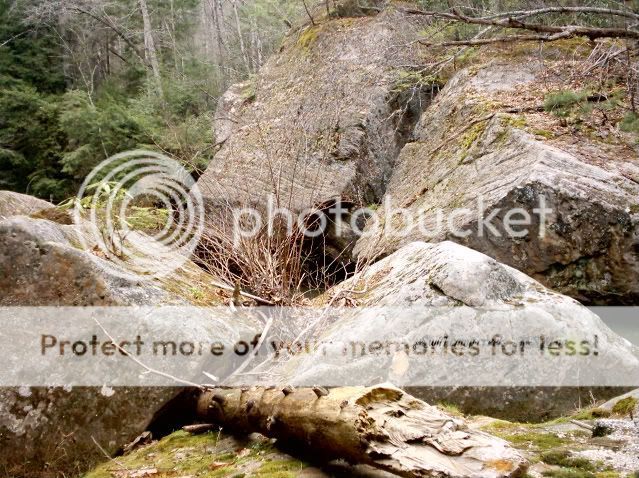
this is the main marker of this creek Swift talks about in his journals, he mentions a rock that hangs over a good size creek and the water flows under it........
swiftcampcreek14.jpg

swiftcampcreek11.jpg


swiftcampcreek12.jpg

here is a view of the boulders blocking the way, the boulders ran from the creek bank across the creek at one point and the creek flowed under them..
swiftcampcreek6.jpg


swiftcampcreek16.jpg
 

truckinbutch

Silver Member
Feb 15, 2008
4,607
1,035
Morgantown,WV
Detector(s) used
Bounty Hunter Landstar
Re: Swift Camp Creek......(pictures)

Thousands of words spoken in those great pictures . Well done on your part and thank you for sharing .
Jim
 

OP
OP
-Ki-

-Ki-

Hero Member
Feb 12, 2009
642
574
EASTERN KENTUCKY
Detector(s) used
MD & Handwand "CaveHunter"Hiker" SonyDigital SLR
Re: Swift Camp Creek......(pictures)

Thank you very much truckinbutch... I must say its one of the more beautiful places in the Red River gorge....
Thanks again -Ki-
 

Curtis

Hero Member
Sep 3, 2008
898
1,008
Cincinnati
Primary Interest:
All Treasure Hunting
Re: Swift Camp Creek......(pictures)

Good stuff!

I noticed a jumble of rocks that you mention kind of go from one side of the creek to the other....hmmm could that be a collapsed natural rock bridge (arch)? When looking for the one Swift mentions we are always looking for it the way we see them in pictures and at the parks “intact”...the earthquakes that have occurred in that area could have caused the arch to fall...even if this one is not it...maybe some of the readers out there may think of that and tie a pile of rocks going from one side of the creek to the other to an arch. I have found the remains of three arches that collapsed in KY near Grayson. There is some good reading out there on arches and their collapsed state…mostly out west.
 

cstraiton

Jr. Member
Sep 29, 2009
56
10
Flatwoods, Kentucky
Re: Swift Camp Creek......(pictures)

Curtis, I live in Flatwoods which is close to Grayson. I would be very interested in checking out the places you know of around here. I just moved up here a few months ago from Lexington and I haven't had a chance to do much exploring yet. I have done a lot of research for this area, but most of it has been for the Flatwoods, Greenup, and Ashland areas. I'm sure this place is full of cool sites like that. Not much development has gone on around here.
 

OP
OP
-Ki-

-Ki-

Hero Member
Feb 12, 2009
642
574
EASTERN KENTUCKY
Detector(s) used
MD & Handwand "CaveHunter"Hiker" SonyDigital SLR
Re: Swift Camp Creek......(pictures)

vamelungeon said:
Those really are some beautiful pictures.

Thank you.........
 

OP
OP
-Ki-

-Ki-

Hero Member
Feb 12, 2009
642
574
EASTERN KENTUCKY
Detector(s) used
MD & Handwand "CaveHunter"Hiker" SonyDigital SLR
Re: Swift Camp Creek......(pictures)

Curtis,
The pile of rocks going across the creek are boulders. Its rock that has broken away from the ridge line, and over the many years ended up in the creek below. From here flash floods have moved them to where they rest today. In this case reaching from one side of the creek to the other. Do you have a picture of one of the broken arches that has fallen, i would love to see one??
 

OP
OP
-Ki-

-Ki-

Hero Member
Feb 12, 2009
642
574
EASTERN KENTUCKY
Detector(s) used
MD & Handwand "CaveHunter"Hiker" SonyDigital SLR
Re: RockBridge & Swift Camp Creek......(pictures)

This may give you guys an Idea about the location i chose for this outing (campout) Its in a real promising Swift area for the Gorge. The creek itself is named for Him, and he makes mention of the RockBridge in his journals. Becky Timmons was known to search this area as well, from Rockbridge there is a rock arch about 3 miles up the creek named for her called Timmons arch.
swiftcampcreek19.jpg

One clue to the location of one mine in the area of Swift camp creek comes from the Draper Papers, a collection of manuscripts of central Appalachia during the period of Swift.
Seven miles above the mouth is a natural rock bridge, and on the northeast side of the creek a short distance is a branch. Follow the branch to its head, then climb the ridge leading to the highest part on your right.
Go along the ridge to a point that is higher than the others where a large rock seems to have fallen from above. Go in between them, this is where we obtained ore.
RockBridge, which spans Swift camp creek, is said to have had, at one time, a map or curious carvings on it. Believed to have since been defaced.

I have since learned in my Research that i have a family connection to Swift, and his journal is through my GGGGG Grandfather. His name can be Found in Steelys book as well. "TOWNSEND" His name was Garrett Townsend. One of the very first of settlers in this area. In Steelys book it describes how in Swift's later fruitless search for the mines, one account has Swift associating with the new settlers of the territory, including men named Townsend, Tye, Anderson, & spurlock.
Some of these men were said to have been given copies of his journal.
Townsend is said to have met Swift while the elderly fellow was exploring down in the gorge, and to have aided Swift and his latter crew by feeding them and escorting them to Lexington, Ky where in his final days Swift gave Townsend his journal, and first hand information about the where abouts of the mines and cave.

In Steelys book "who knew Swift" Townsend---- Chanced across Swift while the old man was searching the Red River Gorge area in Kentucky. He befriended him and took him to Lexington, Ky for treatment. Swift gave him a copy of his journal and then around 1800 is said to have died. This copy apparently passed to Becky Timmons, who continued the search in the area.
 

Curtis

Hero Member
Sep 3, 2008
898
1,008
Cincinnati
Primary Interest:
All Treasure Hunting
Re: RockBridge & Swift Camp Creek......(pictures)

Now that is some good info Ki!

It even looks like a great place!

I'll bring my element detector and we can check it out. The guys at the "meeting of the minds" got a look at it and a demo. We can do the same here, but will keep anything found close to the chest!

Curtis
 

OP
OP
-Ki-

-Ki-

Hero Member
Feb 12, 2009
642
574
EASTERN KENTUCKY
Detector(s) used
MD & Handwand "CaveHunter"Hiker" SonyDigital SLR
Re: RockBridge & Swift Camp Creek......(pictures)

Curtis That's great, id love to check out your element detector. Their is rumored to be a JS, or J.S.M carving and other particular carvings down around the water line on RockBridge. The path from the picnic area down to RockBridge is Farly easy. I'll have a couple topo, and other maps of this area with me, I'll point out what is what along this creek sitting around a campfire, and we can talk about some of the things in more detail. The creek got its name because it was known that on Swifts return trip in 1790 he was searching this creek. Alot of early 1800's maps name it "Swift's Creek". in every version of Swift's journal it mentions a natural rock bridge that the creek flowed under.
 

Top Member Reactions

Users who are viewing this thread

Latest Discussions

Top