Lekain and Swift...

The_Frontiersman

Jr. Member
May 22, 2009
78
59
Eastern Kentucky
Detector(s) used
Garret Ace - 250
Primary Interest:
Other
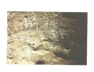
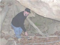
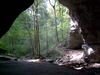
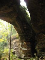
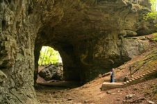
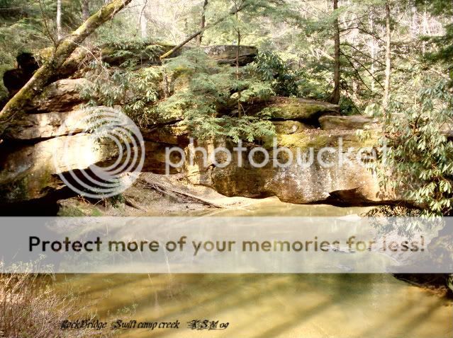
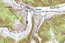
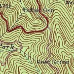
Just wondering if anyone on here may be from around carter county, boyd, or greenup that may be very ineterested in the o'l Lekain silver mine out in Carter County... I have some pretty good information on this spot and actually know the Stamper family in that area really well and I want to maybe put something together. I would also greatly appreciate any thoughts on whether or not Swift could have had operations close to the area. Carter Caves is about 15 or so miles from the spot off Buffalo Creek and some other things Ive found seem to fit a lil bit, but I dont know. I read in the Steely book about the reporter, from here in Ashland, who was blindfolded back in the 80's and taken somewhere and shown some JS carvings, then was reportedly taken to a mine and shown the entrance, or something like that. Does anyone on here know of anything that was followed up on this or what. Swiftsearcher if you have any info. that you may know on the subject I would love to hear from you. Good luck with all your explorations. Any Info from anyone would be great.
 

OP
OP
The_Frontiersman

The_Frontiersman

Jr. Member
May 22, 2009
78
59
Eastern Kentucky
Detector(s) used
Garret Ace - 250
Primary Interest:
Other
i was also wondering if anyone has done any extensive research on the Grayson Lake are in Carter County, or any part of the Grayson resevoir. I read some stuff that was posted on here and would appreciate any info available....
 

Curtis

Hero Member
Sep 3, 2008
899
1,009
Cincinnati
Primary Interest:
All Treasure Hunting
I have done some explorations and research into the possibility of Swift being in the Grayson area. I have found several items (on a map) located near there that an old friend from National Mines Service Company had given me. This was back in the early 1980s. In the past year I have resumed my search and found several really good signs. Nothing that exactly pinpoints Swifts mines, but I did find several Indian silver mines that maybe the Swift mines…maybe not. I have also received info and found some rocks that have turkey tracks and other animals carved on them, they are very, very, old, might be Indian, might be Swifts. The whole thing fits better than most people would like to admit. Carter and Elliot counties abound with items that fit Swifts descriptions. Keep in mind that the key is the direction of the creek that Swift describes…how many fit that description? Not many. Silver bars have been found in Carter County! Cinders too. There has been volcanic activity in Elliott county, even some evidence of a Kimberlitic sprue, so it’s possible that silver is there. There are also supposed to be some fault lines in the two areas. Here is a picture.
 

Attachments

  • Sunday, January 13, 2008 (4).jpg
    Sunday, January 13, 2008 (4).jpg
    50.2 KB · Views: 1,183
  • In Indian mine.jpg
    In Indian mine.jpg
    13.3 KB · Views: 2,278
  • Sunday, January 13, 2008 (4).jpg
    Sunday, January 13, 2008 (4).jpg
    50.2 KB · Views: 944
  • In Indian mine.jpg
    In Indian mine.jpg
    13.3 KB · Views: 2,086
OP
OP
The_Frontiersman

The_Frontiersman

Jr. Member
May 22, 2009
78
59
Eastern Kentucky
Detector(s) used
Garret Ace - 250
Primary Interest:
Other
I thought I read on here somewhere that you had a friend that actually tried to follow the directions that Joseph Brandt wrote about the Little Sandy River and how he supposedly found 4 silver mines on the Grayson Resevoir property, or something like that. I think that you said your friend passed away some time ago, but if you have any of the info he obtained and care to share it I would greatly appreciate it. I too think that alot of signs point to this area and nobody on here cares to venture into this topic. I dont really know if Swift was in the area or not but I do know the deeply rooted history involved in my area with the Shawnee and the Ohio river, and I would like to have any information: maps, waybills, journals - etc. If anyone would care to share some info, I would be more than happy to share some of mine. Thanx.....
 

swiftfan

Sr. Member
Feb 24, 2008
353
491
Pikeville, Ky
Detector(s) used
Garrett Ace 250
Primary Interest:
Other
Well let's see... The Grayson area in on the Little Sandy, which empties in the Ohio river at Greenup, near Portsmouth. If I am not mistaken, the French traded at Porthmouth. Wasn't that a shawnee town? I'll have to research that a little more. Anyway, it would be feasible to say there could have been a series of mines in that area, just wish there was a ore sample from the area to see for sure. But if I had to venture a guess, I'd say there was a good possiblity of the mines being french. I just don't know enough of this yet to say for sure. let me study this some more and see what I can find....

-swiftfan-
 

swiftfan

Sr. Member
Feb 24, 2008
353
491
Pikeville, Ky
Detector(s) used
Garrett Ace 250
Primary Interest:
Other
Thanks for that bit of info. That's something I didn't know. If you don't mind me asking, where did you read that about Washington? I thought that maybe Washington knew Swift in some way. But to keep this short, Thank you. Sometimes we get focused on one thing, and need to take the blinders off to see a bigger picture. I guess I need to study all the characters if I am to better understand the play....Thanks again,

-swiftfan-
 

OP
OP
The_Frontiersman

The_Frontiersman

Jr. Member
May 22, 2009
78
59
Eastern Kentucky
Detector(s) used
Garret Ace - 250
Primary Interest:
Other
I totally appreciate the information. I have an old a copy of Christopher Gist's journal and read the same thing. Gist also commented on some ore he encountered that shimmered while exploring in the area as well, Im not sure the exact location though. I also think Swift was a little south and west of my area, but I do know of several old french and indian mines and several good old hunting camps in Greenup and Carter Counties, perfect for detecting. One spot in Greenup has yielded several old, pure silver ornaments of Indian origin, being so close to the mouth of the Scioto there are tons of these spots. Even where I am in the Boyd County region there are several good spots as well, being about a days indian travel from the Scioto, good camp sights. I live a few miles from where the Big Sandy empties into the Ohio, there are several of these Old sites as well... I am trying to find some information on a holler that has a name of Silver Run, my dad used to live out there, it,s very close to the Big Sandy, and has some very rugged terrain, several old rockhouses, and the remains of an old furnace. I haven't really had a chance to explore much yet, but when the weather breaks Im there.
Swizard, thanx for the input. You seem to know quite a bit about the stuff Im into. Good to know there are people that dont care to share some info. when you need it. Much appreciated. Have you ever looked closely at Lekain? PM me sometime when you get a chance.
 

Curtis

Hero Member
Sep 3, 2008
899
1,009
Cincinnati
Primary Interest:
All Treasure Hunting
Great posts here guys! This is what the forums are all about!
I would like to put in a little bit more for the area around Carter County. The Rock Bridge subject in particular. While it is not a very well known fact that there are at least two existing natural rock bridges in the area, there is one that collapsed after 1928-9 that was huge, in fact suppose to be around 200 feet from the bottom of the creek/river to the top. (Found in old descriptions about the counties). Once again I am not claiming this is the Swift mines, but there sure are a lot of signs he described and no one much has looked near there that I can find out. Not only the signs are there but there has been two counterfeiters, one of which was even in court for counterfeiting in the area. I think he may have found one of the swift mines. There are two sinking creeks near the area I will describe as close to where Caney Creek meets the Little Sandy. There is a really nice light house, a buffalo rock, a haystack rock, the name DAS and 1763 carved on it (Desiree Ann Swift), and as I mentioned in other posts my friend found old money dies wrapped in bearskin and bear grease. I can show you five silver mines in the area. They were defiantly known to the Indians, and I believe Swift knew of them too. I am in the process of documenting everything for a book, unlike someone we know I will share and not discredit your opinions. Analyze my posts and if they help you that is good. I know I appreciate yours!
I also have found the trace that was previously mentioned that goes from Limestone (Maysville) and ends up in the Shawnee town of “Eskippathiki or Eskippakithiki ("blue licks place," for the nearby salt licks along Lulbegrud Creek), was a Shawnee town in what became eastern Clark county. It was also known as Little Pict Town to traders and may have been known to the Iroquois as Kentucky ("meadow lands") from which comes the name of the Kentucky River, which provided access to the town, and from that the name of the state.” http://www.uky.edu/KentuckyAtlas/ky-eskippathiki.html
If you are following the Indian traces from the pine mountain or other gaps, you will eventually come to a trail or trace that leads there. Could that be the area Swift comes thru he say where the Mecca Indians were? If so it can be a lead in to the Grayson area and the Little Sandy. Oh, the fact that silver bars found and the silver containing cinders Henson writes about in Carter County? Were there any bars found further West? If not, then we may have the source of the ones found east of the Carter/Elliott county areas. Some other sites may fit but has there been documented evidence of silver bars, ore, cinders, ect. Being found? No heresy like some of our friends, but evidence? I can show you the two monument rocks too. As I mentioned previously the flow of the streams are very important. Swiftsearcher would have to be sure about the descriptions of the water flows and the two monument rocks to convince me he has it…not saying he doesn’t. Again I am not saying for sure that this is the Swift mine area but it sure does have a lot of stuff there. The previous post with me in one of the mines is some evidence of mining. The tailings would fill a barge.
 

OP
OP
The_Frontiersman

The_Frontiersman

Jr. Member
May 22, 2009
78
59
Eastern Kentucky
Detector(s) used
Garret Ace - 250
Primary Interest:
Other
I also agree that there seems to be some pieces that fit. Swift supposedly stated that they split at the forks of the Big Sandy and He went West - Carter, Elliot counties seem to be west of Lousia, so this lends some credibility to the Idea, at least a thought... I would like to see an old map of those two counties before the Grayson Lake area was underwater, some pretty rugged terrain in that vicinity. I would love to find a good place, in Carter County, thats so rugged that they would have had to hitched their horses 7 or 8 miles away from their spot, and Im sure there are plenty of them.
Curtis, you seem to be a wealth of knowledge in this area and I totally appreciate all your input. Do you have the name of the creek where the old rock bridge used to be? I have explored alot in the Tygart and Little Sandy areas and am pretty familiar with the lay of the land there. Do you know anything of Crane Creek Rd. off of Rt. 1 between Greenup and Carter County? That area fits the description of some of the landmarks mentioned in your above post. I am semi-new to the Swift legend so Im not trying to pry to close to anyones ideas but greatly appreciate any info you care to share. I think that documenting your explorations for a future book really needs to be done. Technology, and good researching in the last few years may open a whole new chapter in this story. I think Steely done a good job, as well as Henson but there are several people on here who have some very good info to add as well.. I dont claim Swifts mines are here in my area but I do know that Lekain was, and that there have NEVER been any serious follow-ups after the collapse a hundred years or so ago. I do know the Stamper family well and plan to get out there as soon as the weather breaks. It's a very interesting story if anyone has looked deep into it.
Thanx for all the input everyone, keep it coming.....


Casey


\
 

Curtis

Hero Member
Sep 3, 2008
899
1,009
Cincinnati
Primary Interest:
All Treasure Hunting
I think the Stamper farm would be a good one to look into. I went by there back in the mid 80s to see where it was. I worked with some guys form National Mines Service Company back then and they were trying to get the money together to buy the rights to try to dig the hill out where the blasting caved it all in. If you would secure permission from them I can bring the device I have and we could see if they were really in the right place after all.

As for the name of the road you mentioned I'll have to check it out and get back to you. It seems funny that Swift mentions the kegs of money and this Indian mentioned them too(found their hiding place but it was gone), that there are two monument rocks right where we think the smelter may have been, that there are two creeks already named Big and Little Sinking creeks, the list goes on and on. There is a lot of Indian activity in this area, even a campground where the ground is covered by the flakes of flint where they made the arrow heads. It could be coincidence, and I am sure there are several places where the rocks and things are similar to what Swift describes. What i did early on was to enlarge a map of the area, then stick pins into it where ever there were places that were described by Swift...well, the wall was full of pins all concentrated within a four mile radius of the monument rocks. Inside of the radius were the 6 Indian silver mines too! I have some new info I need to check out and have to do it during the winter as I am hyper sensitive to poison Ivy/Oak.
Glad you asked about the location of the fallen rock bridge….it is the key….(The ones near Daniel Boone forest are not the only LARGE ones-this one was just as big or bigger) PM me and I’ll tell you where it was and tell you where a set of the Indian stair steps are near there.
 

Curtis

Hero Member
Sep 3, 2008
899
1,009
Cincinnati
Primary Interest:
All Treasure Hunting
Frontiersman,

I looked the area you mentioned over and it is way north of where I am talking about. It does look remote and would be worth looking over. The area i was finding stuff in was very close to the actual coordinates Swift gives. You have to keep in mind the differences in equipment the used verses what we use today. On key factor that most people have not looked at is the median location in Swifts time and how they calculated longitude...latitude was easy and very accurate for them. Longitude on the other hand was not so cool. Today we use Greenwich as the median; it was not the case when Swift started out on his first journey.

The area I have found the Indian mines in is near the place where the Little Sandy and Caney Creek come together if you go a little more north you will find a place where the Little Sandy makes a u-turn around some rocks….that was where some people placed the fallen (in 1930s) Natural Rock Bride that was really high. The two monument rocks are right there too. We had a guy with a depth finder check out the bend it has big rocks in the river 30 feet deep a bunch of them that maybe pieces of the bridge. However my latest investigations have led me to look more toward Carter Caves area as the possible location of the fallen Arch or Natural Rock Bridge. Some on mentioned that the Carter Caves area had four of them and now only has three. I plan to check it out in the near future. If it was in the Carter Caves area (and it is the one Swift mentions) then the mines would have been very near where I am talking about. The area is near Ibex on a Google map 17.5 miles almost directly south of Carter Caves. To address someone’s comment on there not being any natural rock bridges … there ARE Natural Rock Bridges in this area of Kentucky. Here are a few pics I got from the site.
 

Attachments

  • carter caves brige.jpg
    carter caves brige.jpg
    2.5 KB · Views: 1,595
  • fern natural bridge.jpg
    fern natural bridge.jpg
    41.1 KB · Views: 875
  • smokey Bridge.jpg
    smokey Bridge.jpg
    20.7 KB · Views: 2,452

Curtis

Hero Member
Sep 3, 2008
899
1,009
Cincinnati
Primary Interest:
All Treasure Hunting
I checked out the Carter Caves area last week but it was raining so I didn't do any detecting. We did find 3 natural rock bridges and an Arch. In fact the road goes over one, the only one in KY with a road over it according to the park literature.
That sure is an interesting area. We also went to the "box canyon" listed on the site map. It sure fits the Swift description of half of a half moon cliff!
One more item, after looking at the thread title I got to thinking. I have never seen anyone mention that LeKain and Swift may have been contemporaries. If you look at the years they were here, there is some overlap. LeKain was French so what if he was the one Swift was talking about that had mines south of them? Lekain’s mine has never been located…although I would almost bet money it isn’t too far away from the Stampher farm as the cave that Lekain hid the gold and silver in are suppose to be there. There are some definite records on French mining silver on kinnikinnick creek too. That with the location of at least two historical counterfeiters in the area make it a consideration.
 

OP
OP
The_Frontiersman

The_Frontiersman

Jr. Member
May 22, 2009
78
59
Eastern Kentucky
Detector(s) used
Garret Ace - 250
Primary Interest:
Other
Ever since learning about the Swift lore I have thought that there was a possibility of Lekain being the Frenchman who operated his own mine 15 or 20 miles from Swifts operations.. The Carter Caves area is almost exactly 15 or 20 so miles from the Stamper farm and probably not far from the spot where he mined the ore (Lekain). They were "both" in Kentucky at exactly the same time period and is a good probablility that Swift knew of Lekain.. That is so cool Curtis that you have found some of the things that you have in the area and totally lends credibility to the fact that Swift could have in fact had a silver mine in our area.. I think that when they flooded the Grayson Lake area several landmarks were probably sunk, if not even some silver mines.. Very rough and cliffy terrain.. I would love to know a lil bit more on the silver mines you have discovered on the Grayson Resevoir or any more info of any kind.. I have been working too much lately and havent really had time to check the forum but things are slowing down so give me a PM when you get a chance Curtis..
 

swiftfan

Sr. Member
Feb 24, 2008
353
491
Pikeville, Ky
Detector(s) used
Garrett Ace 250
Primary Interest:
Other
I was going to remind everyone that there were french mines in Swift's area according to some of the journals, but I see we are on the same page. If I remember correctly, Swift mentions being North of the area of the French, within the boundries of the London company's grant. Somewhere near the York river? But what is the York river today?
 

Curtis

Hero Member
Sep 3, 2008
899
1,009
Cincinnati
Primary Interest:
All Treasure Hunting
i plan to do a little more research before going back. The fact that the Silver Bars have been found in the area and the dross or cinders were near there help in establishing someone (maybe neither Swift nor Le Kane or maybe both) did some mining and smelting in the area. Near Carter KY where the Lewis furniture company is was suppose to be another french mining operation. Someone had found some of the workings but not the mine. Same for an operation on Kinnicinick.

Now the kicker....are you ready? There is an Indian trace that goes right thru the Carter Caves area! You can read about it in some of the old historical books. I'll post it when I run across it again. If Swift's Indian trace and this one are the same all we have to do is find the jumping off place using one of the natural rock bridges and then going down stream some to find the Indian stair steps...when I was looking at pictures someone had posted on CC I thought for sure one was of the Indian stair steps...but after going there and looking it wasn't ..talk about disappointed...but in retrospect is would have been too close to the natural rock bridge and not on the creek. Sometimes you get excited only to find out you overlooked something.

I also wonder about historical research in France, is there someplace where the records of claims/finds would have been recorded like in Spain and England?
 

-Ki-

Hero Member
Feb 12, 2009
642
574
EASTERN KENTUCKY
Detector(s) used
MD & Handwand "CaveHunter"Hiker" SonyDigital SLR
Great research, ideas, and topic here guys...
Speaking of French mines, there is a known Spanish/French mines located in Jackson Co. Ky in the Wind cave area. It's located on the "warriors path" around Station camp creek in the Jackson/Estill Co area. There are both French and Spanish carvings there, i agate hunt there alot in that area.
Curtis great pictures of the arches, but they are not water made arches. The one Swift mentions in the journal has a good size stream running under it. I'll add a pic to illustrate.
swiftcampcreek19.jpg

Swift mentions crossing the creek at or by using the natural rock bridge. The arches he mentions at the ridge tops were the "hanging rock", "cliff with the hole in it", and the "sky rock"... Finding a rock bridge with water flowing under it is a great key to finding the Swift area, the ones found in Ky you can count on one hand. This rock bridge is the only one west of the Big Sandy River. Every carving and clue Ive found so far is located within 3 miles from the natural rock bridge Ive found. From this rock bridge going in a northwest direction you'll find an Indian Staircase in the cliff. (pic at bottom) Don't let this discourage your efforts, the mines are in fact real, they are either in my area or yours. Its my belief that they are in my area, the reason being is the JS carving, the mine i found, and the name SWIFT carved in a rock within 5 feet of another JS carving id found, i haven't posted a pic of this yet!. And I'm sure you have found clues that lead you to believe the mines are in your area as well... That's whats so great about this forum is that we can share some info and the results of our searches. I do have some pictures and info i "will not" post however, they are key clues of Swift in my area, and my search sites. Great work Curtis on your searches and research, i would still like you to come back this way and hunt the Old Fields "Eskippakithiki" area with me this spring.... Happy hunting -Ki-
 

Attachments

  • Indian-Stairway.jpg
    Indian-Stairway.jpg
    29.4 KB · Views: 812
  • Indian-Stairway.jpg
    Indian-Stairway.jpg
    29.4 KB · Views: 710

boomer

Sr. Member
Jul 8, 2003
487
523
kentucky
Detector(s) used
army all terrain
Lekain was in the area of carter County. Lekain was Captured by Indians on Kinniconick Creek in Lewis county Ky. on a branch of kinney, known as burnt cabin. below cabin branch is a small drain called silver run, heads east, at the head of silver run on the ridge 2 bars of crude silver were found. This place is near were Waite and Sprinkle had there shacks. There has been a lot made of the man by the name of smith who went in a small cave and found bars of silver and gold, also there was a snake carved near the outside of this cave. A man by the name of westfall came there and blew half the hill down trying to open it up. Still there is nothing that i can find that says its in that cave. No one has ever seen it. just one man in the 1770's. The snake points more toward the mouth of the branch than the hill. I was a member of that crew that was with the newsman on that trip. there are 2 JS carvings near Carney creek. One is just across the road from the Carney creek boat ramp about 2 hundred yards along the east side of the cliff. JS with a triangle. The other is on the little sandy river at the line of rock. the large rock that looks like a chimney in the middle of the stream. I was told that during the building of the dam at the lake, the corp of engineers blew up the line of rock to make it easier for boats to go up the river. I forgot to bring this up. The line of rock was also an arch. water flowed under the line of rock. During dry season you could use this has a bridge. Below is a map of the mine at Carter City. Before 1950 you could find a lot of good info on topo maps. Some of the maps i have are from 1927. Most show where old mines used to be, like silver mines. The one at carter City is on the 1927 map. Anyway, on the top of the cliff near the mine is a L and a cross. Lakain???
 

Attachments

  • Carter City Silver mine.jpg
    Carter City Silver mine.jpg
    106.1 KB · Views: 2,031
  • Carter City Silver mine.jpg
    Carter City Silver mine.jpg
    106.1 KB · Views: 761

boomer

Sr. Member
Jul 8, 2003
487
523
kentucky
Detector(s) used
army all terrain
swiftfan: The waybill you have that tells of swift leaving Portsmouth Va. heading west is correct. This waybill is an easy one. I used world wind topo mapping system and followed the directions. it lead to kent Va. just north of fort criswell Va. than southwest to where castlewoods Va. is. than north to the breaks state park, than north to the levisa fork of big sandy river. just east of fishtrap lake, the levisa fork makes a sharp south turn. at this turn there is a creek there called big creek heads east. the town there is called dunlap. not far east is a gap the road runs through. on the early topo maps it was called buffalo gap. at this gap it shows a spring known as indian reed spring. i was there in 1997 and found out that the road was built on the old buffalo trace. there are several carvings at the reed spring. one is a corn stalk just above that is one that says mine-----> ... ... ... the N is backwords and the arrow points east. this is as far as i got on this. castlemans cabin was known as French's castle, French's rest. the map below shows the gap.
 

Attachments

  • Buffalo gap & indian reeds.jpg
    Buffalo gap & indian reeds.jpg
    19.9 KB · Views: 1,285

Curtis

Hero Member
Sep 3, 2008
899
1,009
Cincinnati
Primary Interest:
All Treasure Hunting
Welcome back Boomer!


good to see your posts! I never could get the story straight about the rock bridge being at the line of rocks some say it was some say not...Do you know of any pictures of it before they blew it up? I found some Indian stairsteps not far from it but there are only three steps cut in a rock do you think they may be what Swift was talking about?
 

Top Member Reactions

Users who are viewing this thread

Top