Swifty
Full Member
- Aug 13, 2007
- 125
- 68
- Detector(s) used
- Whites XLT (E- Series)
- Primary Interest:
- All Treasure Hunting
This post is presented especially to Swiftsearcher in response to his post of topic #16, "Re: Here it is", posted on Oct. 8th, 2008 at 1:57:04 PM., between him and "Beale" about each others ideas as to where the upper mines are located.
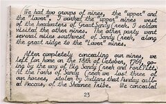
Below is a copy/section of Swifts journal given by Alva Rice of Oil Springs, Ky., it was obtained by Paul Henson. It is said to be the original journal of Johnathan Swift and was signed by him incursively. There seems to be much controversy as to whether Swift worked the upper mines or the lower mines.
The many journals that are out there all state differint facts about this particular subject.
As this journal states, "by Swift", that he and his company separated at the forks of the Big Sandy Creek, Swift says, my group went west to work the upper mines and the others went southwest along the great ridge to the lower mines. I guess it depends on which journal you go by.
L37something-aka- The Swizard