John Swift Landmarks....

-Ki-

Hero Member
Feb 12, 2009
642
574
EASTERN KENTUCKY
Detector(s) used
MD & Handwand "CaveHunter"Hiker" SonyDigital SLR
It is dearly noted that many of the landmarks Swift mentions on his travels can be found in a wide range of areas here and there across many parts of Kentucky. We all know that almost all of the carvings Swift left where trail markers left on beech trees, which are most likely gone this day and age. Swift mentions very few rock carvings, but they are there. What Swift does describe are the many landmarks mentioned in his journal, either being on the way to the mines, or being located near the mines themselves.... I'm starting this topic to discuss the many known landmarks that are located in many diffrent regions of Ky. Not listing the landmarks in any order, or claiming these to in fact be the landmarks Swift mentioned, here are a few examples...

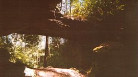
(1 Pic) Swift mentions that between a small salt lick and the furnace that their are 2 remarkable rocks, one that hangs out over the "branch" (not creek) the other rock comes up from the oppsite side and leans against it, and the water flowed under them.
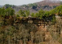
(2 Pic) Swift mentions near his richest mine, you can stand on the "table top" rock above the buffalo rock, looking west he could see a hole through the cliff and see the sky beyond...
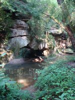
(3 Pic) On their first trip Swift tells of Munday getting lost, and leading them over and crossing the creek using a "natural rock bridge" that the water ran under.
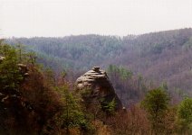
(4 Pic) Swift mentions a "Haystack rock" similar to this one...
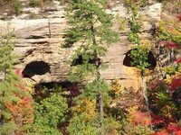
(5 Pic) Swift mentions half-moon shaped cliffs like this one...

These are just a few examples of some of the many landmarks similar to Swifts descriptions in this area. I know other areas have the same landmarks Swift describes. If anyone would like to add or comment on some of the landmarks shown please fill free to reply to this topic. -Ki-

I'll have other landmark pics soon.....
 

Attachments

  • redbyrdarch.jpg
    redbyrdarch.jpg
    18.1 KB · Views: 1,054
  • double.jpg
    double.jpg
    55.5 KB · Views: 1,110
  • 08-29-09 018.jpg
    08-29-09 018.jpg
    111.7 KB · Views: 1,126
  • haystack.jpg
    haystack.jpg
    47.6 KB · Views: 1,056
  • 08-29-09 024.jpg
    08-29-09 024.jpg
    65.6 KB · Views: 1,048

Curtis

Hero Member
Sep 3, 2008
899
1,009
Cincinnati
Primary Interest:
All Treasure Hunting
Great stuff Ki!


Those pictures are great and do match the descriptions (not sure bout the last one though) now if you can just follow the directions from the bridge to the Indian stair steps you might have it made, the stair steps are the key.
 

OP
OP
-Ki-

-Ki-

Hero Member
Feb 12, 2009
642
574
EASTERN KENTUCKY
Detector(s) used
MD & Handwand "CaveHunter"Hiker" SonyDigital SLR
Thank you Curtis, you have some very interesting photo's as well, please feel free to post some pictures if you like... Not everyone would feel comfortable posting pictures of such landmarks, As well as myself I understand this. Some photos i wont post, because they might give away the area of my search to some extent. I'm in no way claiming these to be the actual landmarks, just comparing these to the ones mentioned in Swifts journal. I'm hoping to get others to post pictures of some possable landmarks they've found or encountered on their searches, and we all can compare and discuss to an extent the differences and similarities of these landmarks mentioned by Swift in his journal.
Also one must remember that the journal has been copied and recopied over the last 200 plus years, so certain landmarks, creeks, and names could have been changed, mainly to throw people off, or lead them away from the area of the mines.

The last picture in the above post is of "halfmoon cliff", there is a very interesting story about this cliff involving Becky Timmons and her search for Swift's mines. I hope to have a story, or post on this soon. Again if anyone would have some pictures of some possable Swift landmarks they would like to share please feel free to share....
I should include my best find as of yet during a Swift search last year, i also found another JS just like this one in the late fall of last year.....I should mention the bottom picture in this post, at first it appeared to be JA.S, it turned out to be JO.S, maybe meaning John Swift???
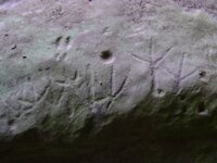
? the O in the carving looks alot like an A, but it's in fact an O.
Im working on adding some more to this post, i should have some more pics soon.... -Ki-
 

Curtis

Hero Member
Sep 3, 2008
899
1,009
Cincinnati
Primary Interest:
All Treasure Hunting
Sorry, here it is smaller--I hope.
 

Attachments

  • tracks2.jpg
    tracks2.jpg
    60.7 KB · Views: 1,396
OP
OP
-Ki-

-Ki-

Hero Member
Feb 12, 2009
642
574
EASTERN KENTUCKY
Detector(s) used
MD & Handwand "CaveHunter"Hiker" SonyDigital SLR
Nice find! Looks like deer tracks too above the turkey tracks going along the bottom... I believe those mean follow direction as well...really good find :thumbsup:
 

OP
OP
-Ki-

-Ki-

Hero Member
Feb 12, 2009
642
574
EASTERN KENTUCKY
Detector(s) used
MD & Handwand "CaveHunter"Hiker" SonyDigital SLR
Found this place back in the fall of last year thought id share it with you guys, needs to be checked out...didnt have time last time by...
 

Attachments

  • red river gorge.jpg
    red river gorge.jpg
    104.8 KB · Views: 2,862

boomer

Sr. Member
Jul 8, 2003
487
523
kentucky
Detector(s) used
army all terrain
Ki, Here is an interesting photo shot. what if??? in the photo you show there are three cave openings, now the map shows four openings. the four caves do not have to be together or side by side, they could be in the hollow or cliff area. is there another opening near by. notice the dots are not touching the cave openings but are separated. on the photo there is a cliff face below the caves, maybe something buried at base of cliff under each cave, the other could be that you have to go inside the cave and find some where an opening. but it depends on another cave near by. is that a cave opening below?
 

Attachments

  • red river gorge.jpg
    red river gorge.jpg
    104.8 KB · Views: 2,306
  • Caves Swift Map.jpg
    Caves Swift Map.jpg
    1.3 KB · Views: 1,657

Curtis

Hero Member
Sep 3, 2008
899
1,009
Cincinnati
Primary Interest:
All Treasure Hunting
Hey guys,

Please see the survey for confirming your avatar and vote on the time to be at Grayson and confirm that you will be at the "Meeting of the Minds" we have a loot to talk about ad copare notes. With enough markers for locations on a large map(I'll bring a big Topo of the area) we can surely get some more ideas on the pathways Swift and others took into and out of the area...more and more places where coins, bars, signs, and landmarks are located this wil give us a better picture of the areas and narrow things down on places to look. We are also planning on trying to get a boat or two to explore with... Is the boat idea going overboard? Seems like they were $125 for 4-5 hours.
what do you think?
 

OP
OP
-Ki-

-Ki-

Hero Member
Feb 12, 2009
642
574
EASTERN KENTUCKY
Detector(s) used
MD & Handwand "CaveHunter"Hiker" SonyDigital SLR
Boomer i have had the chance to get back near to this place, it does appear to be a cave system! someof which have either over time have been filled in or just from colapse. Knowing this site on a map, it does appear to be in the same location as on the Devil creek map......
 

KY Hiker

Bronze Member
Oct 28, 2014
1,537
3,220
North Central Kentucky
Detector(s) used
Whites
Primary Interest:
All Treasure Hunting
Found this place back in the fall of last year thought id share it with you guys, needs to be checked out...didnt have time last time by...

Those are salt peter mines as seen from Tunnel Ridge Road. You can get to them off trail from a section of Rough Trail along Martin's fork. They sit basically across the valley from D. Boone Hut which is another Salt Peter mine location.
 

dsn

Tenderfoot
May 22, 2014
8
13
Ky
Primary Interest:
All Treasure Hunting
Curtis has you ever got to go look at this rock
 

Top Member Reactions

Users who are viewing this thread

Top