Yep, another Swift Waybill (part 1 and 2)

boomer

Sr. Member
Jul 8, 2003
487
523
kentucky
Detector(s) used
army all terrain
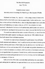
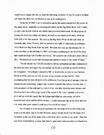
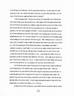
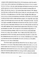
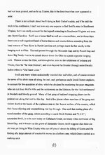
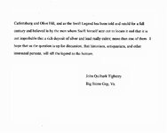
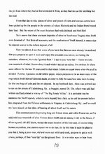
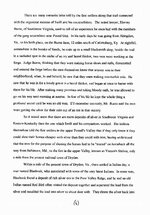
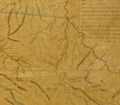
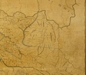
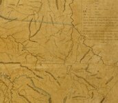
Catlettsburg Ky. was named after the Catlett family. There old grave yard does have a grave marker that reads JO SWI T on a small piece of sandstone. The name is vary faded, some letters you can make out. below, if you have trouble reading it tap the scan under the picture. i will install the rest tomorrow.
 

Attachments

  • cattletsburg 1.jpg
    cattletsburg 1.jpg
    225.7 KB · Views: 932
  • Cattletsburg 2.jpg
    Cattletsburg 2.jpg
    313.2 KB · Views: 904
  • Cattlesburg 3.jpg
    Cattlesburg 3.jpg
    308.2 KB · Views: 871
  • Catlett 4.jpg
    Catlett 4.jpg
    294.1 KB · Views: 834
  • Catlett 5.jpg
    Catlett 5.jpg
    296.7 KB · Views: 805
  • Catlett 8.jpg
    Catlett 8.jpg
    69.7 KB · Views: 820
  • Catlett 7.jpg
    Catlett 7.jpg
    293.7 KB · Views: 748
  • Catlett 6.jpg
    Catlett 6.jpg
    304.6 KB · Views: 788

cstraiton

Jr. Member
Sep 29, 2009
56
10
Flatwoods, Kentucky
Re: Yep, another Swift Waybill

Using Google Earth and some online resources, I tried to retrace this account of Swift's Journey down the Big Sandy starting at Catlettsburg and taking the Levisa Fork which is the west fork or Kentucky side as mentioned in the story. I followed it down about 70 miles to Allen Kentucky. In Allen the Levisa Fork splits again, so I assumed that would be the tributary they were talking about in the story. I attempted to follow the west fork, or took a right as described in the story, for an additional 12 miles. After about 6 miles that tributary narrows significantly, so at this point I'm kind of questioning my navigational skills. I do some additional research and found that due to a "massive earth moving project completed in 1987" they rerouted the Levisa Fork around the city of Paintsville. So needless to say, following the river as Swift did is almost impossible today since the land has changed so much. I am currently looking for some older maps of Kentucky waterway's that will make this research more accurate. I'm pretty certain that I am not the first one to attempt this reconstruction, and probably won't be the last, but this is a pretty fun part of treasure hunting that I just love. KI you always seem to have the uncanny ability to pull an old map out of your back pocket at just the right moment. I wonder if you might have one to fit the bill here in this instance.
 

OP
OP
boomer

boomer

Sr. Member
Jul 8, 2003
487
523
kentucky
Detector(s) used
army all terrain
when i first started doing this stuff, i made a big mystake. i ran around to those locations, book and map in hand. i never got anywhere. just a lot of walking and nothing to show for it. a year later i wised up. when you read swifts journal, notice that some of the paragraphs seem out of place. when i was in north carolina i was able to talk with some of the descendants of the miners. i found that the journal is not complete. the great grand son of blackburn. said that there was a journal that told the whole story. he also said that whats out there now is bits and pieces. over the years a lot was taken out. There are two other maps, he thinks one was done by montgomery, but all this was stolen years ago. follow the trails. your doing the right thing, follow the trail. i never worked on this one. but i will check the maps. we do know that the catlett family lived at the mouth of sandy. catlettsburg was named after them. they became rich and there is the grave. i wonder if its a later swift, maybe a son?? so many different stories. i do a lot of research before i hit the road.
 

-Ki-

Hero Member
Feb 12, 2009
642
574
EASTERN KENTUCKY
Detector(s) used
MD & Handwand "CaveHunter"Hiker" SonyDigital SLR
What a great story, thanks Boomer for posting it. I agree with boomer, research research research, their are to many lose ends with the journals of today. I'd love to find a complete version to clear up any lose ends, the story might just be a bit diffrent if so. Swift even mentions there were 3 trips that he made that he did not write about, what could he have been up too?

cstraiton, i looked through my maps and found a couple of that area. They are old maps, from early to mid 1800's...
The first map is from 1814...
The other map or maps is from 1850...

Hope this helps..... -Ki-
 

Attachments

  • Ky 1814.jpg
    Ky 1814.jpg
    171 KB · Views: 752
  • forks of sandy.jpg
    forks of sandy.jpg
    96.4 KB · Views: 716
  • Swift route.jpg
    Swift route.jpg
    102.8 KB · Views: 726
  • Sandy river route.jpg
    Sandy river route.jpg
    89.6 KB · Views: 835

cstraiton

Jr. Member
Sep 29, 2009
56
10
Flatwoods, Kentucky
I knew you would have some maps laying around KI, thanks for posting them. Thanks for the advice Boomer. When I discovered this account of Swifts journey, I had just moved to Greenup County and was anxious to explore the area. Since Catlettsburg is only 10 miles from me, I was excited to see that Swift was in this area. Even though my research proved to be unfruitful, it was still an enjoyable experience nonetheless. I may give it another attempt when the weather gets nice this spring using some period maps. I'm always looking for an excuse to get out there and do some camping and kayaking.
 

OP
OP
boomer

boomer

Sr. Member
Jul 8, 2003
487
523
kentucky
Detector(s) used
army all terrain
cstraiton: you will have to go with us this spring.
Ki: those maps helped. if the old man left catlettsburg and headed 70 miles? his age may be a factor in this. thinking about all the turns on the river. of course he used the old road, than a buffalo trail. Prestonsburg Ky. is 65 miles, road miles. rt. 23 follows the trail vary close. at Prestonsburg there are two creeks that head west abbott and HMMM Spurlock creek. that's the spurlock who had a copy of swifts journal and there was a spurlock with swift. if the old man was wrong in his estimate of distance traveled. could paintsville ky. be the spot, paint creek comes in from the west. 12 miles west would put you on rockhouse creek? then we have the little sandy river, blaine creek heads west from louisa ky. and both head waters are near each other. it all depends on whether his 70 and 12 are correct. but he did say (about). was he lost?---> going back, he did say (on the second day) he should have been back at the sandy river? ahhh nothing like a story of mystery, deception and treasure.
 

HCA1961

Jr. Member
Feb 1, 2010
44
16
Pikeville, KY
Detector(s) used
Fisher F2, Fisher F-Point pinpointer, Gray Ghost ears
Great information, Boomer! This is the kind of stuff that I feel very fortunate to find. I'll play around with it tonight with some of my maps.

--Chris
 

swiftfan

Sr. Member
Feb 24, 2008
353
491
Pikeville, Ky
Detector(s) used
Garrett Ace 250
Primary Interest:
Other
Boomer, this resembles the area that Daniel Boone spent a winter in 1767...it is close I believe.
 

-Ki-

Hero Member
Feb 12, 2009
642
574
EASTERN KENTUCKY
Detector(s) used
MD & Handwand "CaveHunter"Hiker" SonyDigital SLR
Swiftfan....
Now let's look at Boones trip in 1767, Boone's trip was in the Fall or early winter of 1767 around the same time Swift made his trip into Kentucky (from the book Life of Daniel Boone) "On Boone's first trip into Kentucky he came by way of the Sandy River, Boone and company started from the upper Yadkin river valley in North Carolina. They crossed the Blue ridge, Alleghenies, crossed the Holston and Clinch rivers near their headwaters. They fell upon the headwaters of the West fork of the Big Sandy River, and continued their journey along its banks. They came to a "salt spring" ten miles directly west of the present-town of Prestonsburg on the Lick fork of Middle creek, a tributary to the West of "Louisa fork" of the Big Sandy river in Floyd County, Kentucky.
Boone here got caught in a huge snow storm.
On this trip Boone does compare a Salt lick they came across to a mine of the precious metals...

Awesome Swiftfan thanks for jogging the memory, Boone was in that area in 1767. The story tells of Boone trying to find the place where John Finley would tell him story's about (eskippakithiki the former Shawnee village, and the great meadow land of endless hunting. He could have been trying to follow Swift, and used the hunting as cover. If I'm not mistaken i think Swift entered Ky through Pound Gap in 1767, I'll have to check on that....
 

-Ki-

Hero Member
Feb 12, 2009
642
574
EASTERN KENTUCKY
Detector(s) used
MD & Handwand "CaveHunter"Hiker" SonyDigital SLR
cstraiton, Not a problem, glad to help anytime....were all trying to get together this spring, location as of yet unknown, but we'd all like to have you there. As well as everyone.

Boomer, if you notice on those maps it shows a few roads, these could be some of the paths you mention. These would have been some of the first roads around that time. -Ki-
 

truckinbutch

Silver Member
Feb 15, 2008
4,607
1,035
Morgantown,WV
Detector(s) used
Bounty Hunter Landstar
One of the biggest boogers in pinning any of these journals down is the accuracy of the scribe who determined the distance traveled each day .
How many of you have hiked out 5 miles and when tired swore it was 7 miles back ?
 

swiftfan

Sr. Member
Feb 24, 2008
353
491
Pikeville, Ky
Detector(s) used
Garrett Ace 250
Primary Interest:
Other
If Boone was following Swift in 1767, That would put them in the same area IF the Cattletsburg paper is correct. But we all know that there is so much out there, we have to also take this with a grain of salt. I think a little drive over there for me would be in order, to scout the area. Maybe today or tomorrow sometime..
 

-Ki-

Hero Member
Feb 12, 2009
642
574
EASTERN KENTUCKY
Detector(s) used
MD & Handwand "CaveHunter"Hiker" SonyDigital SLR
Swiftfan... The information i read on Boone and this trip can be found in "The life of Daniel Boone". Its pretty much fact, and some even in Boones own words. It makes sense now why Swift was trying to leave for the mines in secret, plus Swift took around 100 pack animals on this trip, with that many animals leaving in secret would be a hard task, plus that many animals would leave a distinctive trail i would think. By 1767 Swift knew the country alot better than Boone, Id say Swift managed to elude Boone to some extent. But your right we all have to take this with a gran of salt. Good luck on your trip, finally the weather breaks, I hope to get out Sunday..... -Ki-
 

-Ki-

Hero Member
Feb 12, 2009
642
574
EASTERN KENTUCKY
Detector(s) used
MD & Handwand "CaveHunter"Hiker" SonyDigital SLR
Boomer,
On the maps above it shows a road (trail) you mentioned that follows the west fork all the way from the mouth of the Big Sandy, Looks like to around Prestonsburg, there the trail does go west following a Creek(rt 23 & us 460) From here on these old maps it shows us460 crossing the Licking and continuing west following the Red River for a bit then heading on to around Mt. Sterling. Around this area the trail forked a couple directions north and south. The old Indian trail coming in Kentucky through Pound Gap also takes you close to these areas, just a bit more south following hwy15 and 52 which brings you to Proctor, Lee Co. Then follows rt11 north to Mt. Sterling.

In the story above it does mention carvings that were made on a rock of a horseshoe, and a couple other marks...... Key would be finding the horseshoe carvings, I believe this mark would still be there today. -Ki-
 

-Ki-

Hero Member
Feb 12, 2009
642
574
EASTERN KENTUCKY
Detector(s) used
MD & Handwand "CaveHunter"Hiker" SonyDigital SLR
truckinbutch said:
One of the biggest boogers in pinning any of these journals down is the accuracy of the scribe who determined the distance traveled each day .
How many of you have hiked out 5 miles and when tired swore it was 7 miles back ?
On a good day walking id say these men could have traveled 10 to 15 miles easy depending on the route. The men would have taken the easiest route. Also if the men were on horse back they could have traveled 25 to 35 miles easy depending on the route, which i believe they were.. In Swifts journal he tells of Indians stealing a few horses from them, so i believe they were on horseback. In the area around his mines they had to tie the horses up and walk the rest of the way...... But your very right it depends on the persons writing the story, and how their travels were easy or hard. Some miles could be streched. I know ive walked 3-4 miles on some hikes that feel like i walked 10 miles because of the up and down trail.....Good point truckinbutch...
 

swiftfan

Sr. Member
Feb 24, 2008
353
491
Pikeville, Ky
Detector(s) used
Garrett Ace 250
Primary Interest:
Other
Well I found the Salt Springs today. It is pretty much in the middle of the town of David. I will post the pictures as soon as I can. Right now they are too big, and have to be compressed I guess in order to post them..
 

HCA1961

Jr. Member
Feb 1, 2010
44
16
Pikeville, KY
Detector(s) used
Fisher F2, Fisher F-Point pinpointer, Gray Ghost ears
I'm in for Saturday or Sunday! (It's MUCH harder for me to get away during the week.)
 

Top Member Reactions

Users who are viewing this thread

Top