Swifty
Full Member
- Aug 13, 2007
- 125
- 68
- Detector(s) used
- Whites XLT (E- Series)
- Primary Interest:
- All Treasure Hunting
Hello all ye Swift Hunters,
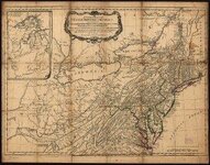
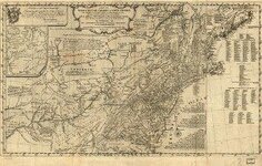
Here are some maps I thought I'd turn ya'll on to, they show the Shawnee Village of Eskippakathiki, The Upper and Lower Shawnee Towns, Pict Town, and Chilicothe or The Hocking Hills area in Ohio. The show the War Path, a remarkable rock! as well as the latitudes and longitudes of many places, rivers and routes that were familiar to Christopher Gist, Thomas Walker, John Findley, Alfred Munday, Jonh Swift and Daniel Boone, etc. at that time. Dig in!!!
Sincerely,
Bill N. -aka- "The Swizard on T-net"