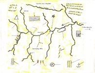
I have had several PM's on this map, asking for info on the location and if the map is real or fake, what the symbols mean. Well, it is a real location and the symbols are of rock and land formations. This map can be used in many counties in KY., Tenn., VA. and WVA. and a lot have been on a wild goose chase for years. A lot of money has been wasted making the map fit their location. This map has been changed many times to hid or enhance. I have four and each is diffrent. There is only one place in the four state area, that this map fits. It has taken many months of searching topo maps and field trips to locate it. The closer i got to this location the more i began to wonder (Why). There are so many counties with the same swift rock carvings. oh well. Below is the map.
You are using an out of date browser. It may not display this or other websites correctly.
You should upgrade or use an alternative browser.
You should upgrade or use an alternative browser.
Swift Map
- Thread starter boomer
- Start date


Curtis
Hero Member
Thanks Boomer!
1320
Silver Member
If this map is showing Beaver Creek in Menifee County....that's where I live! How cool. I'm not an avid JS follower but it's neat to think that he might have walked across the same dirt as I and possibly been in the same shelters and caves in this area.
mdavis3238
Greenie
- Nov 22, 2012
- 11
- 11
- Primary Interest:
- All Treasure Hunting
I have had several PM's on this map, asking for info on the location and if the map is real or fake, what the symbols mean. Well, it is a real location and the symbols are of rock and land formations. This map can be used in many counties in KY., Tenn., VA. and WVA. and a lot have been on a wild goose chase for years. A lot of money has been wasted making the map fit their location. This map has been changed many times to hid or enhance. I have four and each is diffrent. There is only one place in the four state area, that this map fits. It has taken many months of searching topo maps and field trips to locate it. The closer i got to this location the more i began to wonder (Why). There are so many counties with the same swift rock carvings. oh well. Below is the map.
Hi, ive been researching for awhile, noticed he mentions, going thru kings port crossing the holsten. then another river unknown to him, he may not have Known there was a north fork of holsten,,
 valley which mecca indians, etc.. talks about 20 miles, do you think maybe he meant 2 miles or 4 miles.. etc...
he also mentions where he goes to the mines is alot of water. every branch he crosses is lots of water. Ive looked all over KY, and VA, topo maps etc. there is no where like that. there is one area in TN where there is water showing in all branches. and there is a meteor crater in area.. well what comes from Meteors, gold. silver ,etc... I recently heard a story of a hunter ,stumbled on a old mine 10yrs ago in this area. said you couldnt see it unless stood a certain angle cause of a big rock blocking enterance,, he went in and timbers holding up ceiling all around,, and a blueish rock. all over the walls?? Im going to see if he can remember what AREA it was in.. might be worth checking out..?
K
Kentucky Kache
Guest
...and there is a meteor crater in area.. well what comes from Meteors, gold. silver ,etc...
Gold/silver comes from meteors? Can you explain further?
mdavis3238
Greenie
- Nov 22, 2012
- 11
- 11
- Primary Interest:
- All Treasure Hunting
Gold/silver comes from meteors? Can you explain further?
that is how these minerals are brought to earth. are in meteors,, gold and silver and other minerals. were not local to earth. meteorites brought them to earth,millions of yrs ago,,, most minerals found are close to ancient meteor craters... did you know that, the entire town of Middlesboro KY sits in a huge ancient crater... and close the there, silver has been found..
K
Kentucky Kache
Guest
that is how these minerals are brought to earth. are in meteors,, gold and silver and other minerals. were not local to earth. meteorites brought them to earth,millions of yrs ago,,, most minerals found are close to ancient meteor craters... did you know that, the entire town of Middlesboro KY sits in a huge ancient crater... and close the there, silver has been found..
Yes, I knew about Middlesboro sitting in a crater. But are you saying that gold and silver is not native to earth, but comes only from meteors? So the big veins of gold and silver inside mountains came from meteors?
mdavis3238
Greenie
- Nov 22, 2012
- 11
- 11
- Primary Interest:
- All Treasure Hunting
Yes, I knew about Middlesboro sitting in a crater. But are you saying that gold and silver is not native to earth, but comes only from meteors? So the big veins of gold and silver inside mountains came from meteors?
yes . meteors and comets crashing to earth millions of yrs ago when it was molten,and even now when one hits.. brings. carbon, and other minerals. there was a show on history channel few months ago about it.. there is more gold found in Africa. because that is where you find the most craters on earth.. so reason the have more gold in that area..
the carbon brought by meteorites is what diamonds are made of aswell....
K
Kentucky Kache
Guest
yes . meteors and comets crashing to earth millions of yrs ago when it was molten,and even now when one hits.. brings. carbon, and other minerals. there was a show on history channel few months ago about it.. there is more gold found in Africa. because that is where you find the most craters on earth.. so reason the have more gold in that area..
the carbon brought by meteorites is what diamonds are made of aswell....
Personally, I don't think they know everything they talk about, but that's another subject, I guess. If they're right about the earth and the other planets forming from space particles, then how could anything be "native"? It would seem the earth itself is not exactly native.
swiftfan
Sr. Member
Seems like I can replace one of those lines as a ridge line, and fit the area to a suspected area of mine. Replace the question marks with the symbols, and see what happens. Theory? Yes. But the descriptions gave me the idea. This makes the search area under part of a lake now, but may be something to look into anyway..
-swiftfan-
-swiftfan-
Sevenfeathers777
Full Member
- Jul 4, 2022
- 156
- 310
Hey your right about it! We need to talk!I have had several PM's on this map, asking for info on the location and if the map is real or fake, what the symbols mean. Well, it is a real location and the symbols are of rock and land formations. This map can be used in many counties in KY., Tenn., VA. and WVA. and a lot have been on a wild goose chase for years. A lot of money has been wasted making the map fit their location. This map has been changed many times to hid or enhance. I have four and each is diffrent. There is only one place in the four state area, that this map fits. It has taken many months of searching topo maps and field trips to locate it. The closer i got to this location the more i began to wonder (Why). There are so many counties with the same swift rock carvings. oh well. Below is the map.
KY Hiker
Bronze Member
- Oct 28, 2014
- 1,537
- 3,220
- Detector(s) used
- Whites
- Primary Interest:
- All Treasure Hunting
Sadly, Boomer passed away a few years ago.
KY Hiker
Bronze Member
- Oct 28, 2014
- 1,537
- 3,220
- Detector(s) used
- Whites
- Primary Interest:
- All Treasure Hunting
The Imlay map has been altered when you search online, 'Reputed Silver Mines' has been removed, here is a copy of it I have. Just sharing for researchers who may be looking for it, also a portion of a Swift Journal version that describes the topography on and along Swift Camp Creek. Just by the way it is written alone, I don't believe this to be authentic...but a rewrite by someone in much more recent times. The monument rocks (the size of small homes) are easy to find on Swift Camp Creek at the junction of Dog Fork by hiking Swift Camp Creek trail...a beautiful hike.
...We reached the Big Sandy River after much hardship, but without mishap.
Munday knew the trails and the habits of the Indians so well that we were able to avoid them. From there we traveled west through a hilly country, following the creek bottoms until we came to a rocky country that looked like the end of the world.
A turbulent river was before us, and following its windings from the heights we came to the mouth of a large creek. Our path fell rapidly to the creek, which has small branches running through deep ravines having great cliffs rising on either side. On the opposite side of the creek from where we were the land rose up to a cliff that stood far back from the creek, and this cliff has a great hole in its side near the top. We called that the "lighthouse" we could see clear through it, and see the sky beyond.
Munday did not know where we were, but after following the creek on a southwest course, he reconized the hills on the opposite side, and said that if we were over there he knew how to reach the Indian trace, which was some miles below, and having reached the trace he would know how to go to the mine. He said that we had to go through a laurel thicket and then down a flight of steps that the Indians had cut in the side of the cliff at the top of it; and that across the creek from the foot of the cliff at that point and in the cliffs of the other side was the mine.
We crossed the creek by a natural rock bridge, and Munday led us to a place that the Indians used for a camping ground, and for games when on thier hunting trips. This was not the time of year for them, and we did not see any of them. We camped there, and a creek flowed by our camp. When we went out with Munday again he could not find the laurel thicket, and we came again to the rock bridge, and from there we went down a rocky branch, and there were vines closing the entrance mouth of the branch.
We camped in this branch and kept our horses there. We could leave them there grazing while exploring the country, because the cliffs made an enclosure except for the entrance, which was closed by grapevines. Munday could not find the cliff where the mine was, but one day he called out to us and said: "here is the laurel thicket, i know the way now" Through this thicket we reached the steps in the cliff. From there i can point to the mine." It was hard to get through the thicket. We could not take our horses, and we stumbled many times and had to fight and cut our way. We got to the Indian steps which are cut in the side of the cliff.
You can stand on top of the rock there and look across the creek, and to your left the creek cuts through the cliff, and the cliffs in front are shapes of a half-moon.
Just above the creek, on the other side, there is a ledge, and higher up another ledge, and up near the top of the cliff a third ledge, and between the second and third ledges Munday said was the opening to the mine. Now we crossed the creek and climbed up to the second and third ledge, and then we went west a couple of hundred yards and found the mine. There was a big rock that looked like a buffalo sitting down, resting on the slope within a few hundred feet of the opening to the mine. We cut our names on that rock, Swift, Munday, Jefferson and others. We got ore and we smelted in a rock house which is in the second ledge. This rock-house faces the sunrise, and looking out there is a branch of a creek that comes in from the southwest and just below the mouth of that branch are three monument rocks, one large one, and two small ones. They are layers of rock and they taper to a point at the top...
Hope this helps someone. The 'Reputed Silver Mines' are located East of the headwaters of the KY River and West of the Big Sandy on the Imlay map below. Why it has been altered online is still in question. Save this copy for your own records.
KY Hiker
Bronze Member
- Oct 28, 2014
- 1,537
- 3,220
- Detector(s) used
- Whites
- Primary Interest:
- All Treasure Hunting
Here is a topo map for reference to journal version above, remember the dark dense lines are steep cliffs. Dog Fork junction with Swift Camp Creek is where you will find the monument rocks, Rock Bridge is up stream (South) about 2 miles. Find the Buffalo Rock with the initials, mine near ridge top on third ledge, furnace on the second ledge facing East. This is where Mrs. Timmins claimed to find the old shaft in the late 1800's.

Top Member Reactions
-
 2404
2404 -
 1116
1116 -
 1111
1111 -
 901
901 -
 819
819 -
 807
807 -
 764
764 -
 733
733 -
 644
644 -
 518
518 -
 476
476 -
 468
468 -
 459
459 -
 429
429 -
 414
414 -
 408
408 -
O
369
-
 362
362 -
 353
353 -
 348
348
Users who are viewing this thread
Total: 2 (members: 0, guests: 2)

Latest Discussions
-
-
-
-
 Recent finds - Large Cents, Jaw Harp, Cufflink, Buckle and Buttons
- Latest: Urien of Rheged
-
