Possible Bell

OP
OP
1320

1320

Silver Member
Dec 10, 2004
3,434
2,308
East Central Kentucky
There was a gravel road beside the church and I drove back it about 1/2 mile, nothing there like I expected.... a 'standing rock' was no where to be seen. There was some oil pumps running and an open field area. Interesting it was an Indian landmark though. All I wanted was a picture and a reason for the name, I guess the reason will have to do. I wonder if the rock is in someones' backyard? The description sounds like what I picture as a monument rock or peculiar rock.
Sometimes just reading a map one can find things in plain sight, so when i saw it on a map it sparked my interest.
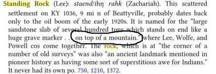
This might help
 

Attachments

  • sr.JPG
    sr.JPG
    46.1 KB · Views: 116
Last edited:

KY Hiker

Bronze Member
Oct 28, 2014
1,537
3,220
North Central Kentucky
Detector(s) used
Whites
Primary Interest:
All Treasure Hunting
This might help

Yea, I guess another trip by there in Winter may reveal something, maybe a local can point me to the rock. At several hundred tons, that rock should still be there unless it was blasted. The area sits pretty much on top of the ridge with a few areas that roll upward here and there but they are tree covered. The gravel road seemed to be a mineral rights access road for pump maintenance, I only remember one home back there on the left with several acres fenced around it on a rise. The church and gravel road were on the North side of the paved road. StandingRockZoomTopo.jpg
 

Last edited:

franklin

Gold Member
Jun 1, 2012
5,036
7,168
Detector(s) used
Garrett ADS-7X, Fisher Two Box M-Scope, Mother Lode Locator, Dowsing Model 20 Electroscope, White's TM808, White's TM900, Inground Scanners
Primary Interest:
All Treasure Hunting
Yea, I guess another trip by there in Winter may reveal something, maybe a local can point me to the rock. At several hundred tons, that rock should still be there unless it was blasted. The area sits pretty much on top of the ridge with a few areas that roll upward here and there but they are tree covered. The gravel road seemed to be a mineral rights access road for pump maintenance, I only remember one home back there on the left with several acres fenced around it on a rise. The church and gravel road were on the North side of the paved road. View attachment 1626821

Ky Hiker, I do not know for sure but if you go North on the Big Bend Road about 6 tenths of a mile and take a right on Standing Rock Road to it's end where there are some old buildings or water tanks, continue another one quarter mile to a clearing along the ridge and then turn Northeast about 4 degrees for one tenth of a mile, should take you to the Standing Rock?
 

KY Hiker

Bronze Member
Oct 28, 2014
1,537
3,220
North Central Kentucky
Detector(s) used
Whites
Primary Interest:
All Treasure Hunting
Ky Hiker, I do not know for sure but if you go North on the Big Bend Road about 6 tenths of a mile and take a right on Standing Rock Road to it's end where there are some old buildings or water tanks, continue another one quarter mile to a clearing along the ridge and then turn Northeast about 4 degrees for one tenth of a mile, should take you to the Standing Rock?

Thanks, Are you are familiar with the area? I saw a gate with a no trespassing sign....no signage along the gravel road(s) as to the roads' name? Google maps is not very accurate in this part of KY. I don't see anything on Google Earth casting a shadow where the county lines come together where the rock should be.
 

Last edited:

franklin

Gold Member
Jun 1, 2012
5,036
7,168
Detector(s) used
Garrett ADS-7X, Fisher Two Box M-Scope, Mother Lode Locator, Dowsing Model 20 Electroscope, White's TM808, White's TM900, Inground Scanners
Primary Interest:
All Treasure Hunting
Thanks, Are you are familiar with the area? I saw a gate with a no trespassing sign....no signage along the gravel road(s) as to the roads' name? Google maps is not very accurate in this part of KY. I don't see anything on Google Earth casting a shadow where the county lines come together where the rock should be.

The standing rock could be within five miles and still be considered at the corner of the three counties. Standing Rock should be up the road called Standing Rock Road?
 

KY Hiker

Bronze Member
Oct 28, 2014
1,537
3,220
North Central Kentucky
Detector(s) used
Whites
Primary Interest:
All Treasure Hunting
Yea that makes sense, but the clearing it leads to has a bunch of oil tanks and equipment in it and as I recall it was gated...like I said there was no road sign that said Standing Rock Rd or [ standing rock ---> ] . The only thing I saw was the church with the name, a true 'blink town'!

I will have to stop by there again! A several hundred ton sandstone sitting upright like a tombstone that the Indians had superstitions of and that the pioneers used as a landmark. Sounds like its worth a picture if nothing else. Almost had to be a trace nearby as well.
 

Last edited:

KY Hiker

Bronze Member
Oct 28, 2014
1,537
3,220
North Central Kentucky
Detector(s) used
Whites
Primary Interest:
All Treasure Hunting
You might try posting in the Lee County Topix forum, I bet someone would get you in the right direction.

You would think it had enough historical value to have a picture online or something! That's the thing, is it in Lee Co. ?
Just visited the forum you mentioned.... wow, I don't think I'll get help from that!
http://www.topix.com/forum/county/lee-ky

I emailed the county judge, maybe they can forward it to the right person/historian.
 

Last edited:

KY Hiker

Bronze Member
Oct 28, 2014
1,537
3,220
North Central Kentucky
Detector(s) used
Whites
Primary Interest:
All Treasure Hunting
Perhaps! But I'm the kind of person who likes to open all the doors even if someone tells me there is a brick wall behind it...I need to see for myself.
 

franklin

Gold Member
Jun 1, 2012
5,036
7,168
Detector(s) used
Garrett ADS-7X, Fisher Two Box M-Scope, Mother Lode Locator, Dowsing Model 20 Electroscope, White's TM808, White's TM900, Inground Scanners
Primary Interest:
All Treasure Hunting
Perhaps! But I'm the kind of person who likes to open all the doors even if someone tells me there is a brick wall behind it...I need to see for myself.

Maybe this will help? Screenshot_2018-08-31 Journal of the House of the General Assembly of the Commonwealth of Kentuc.png

It is in one of the corners of a survey made for Wolfe County.
 

franklin

Gold Member
Jun 1, 2012
5,036
7,168
Detector(s) used
Garrett ADS-7X, Fisher Two Box M-Scope, Mother Lode Locator, Dowsing Model 20 Electroscope, White's TM808, White's TM900, Inground Scanners
Primary Interest:
All Treasure Hunting

KY Hiker

Bronze Member
Oct 28, 2014
1,537
3,220
North Central Kentucky
Detector(s) used
Whites
Primary Interest:
All Treasure Hunting
Wow, that is NOT a several hundred ton sandstone slab LOL!
Thanks franklin, I think I have seen larger landscape stones in the corner of some my neighbors' yards!
I wonder why that little thing would raise Indian's superstitions? I doubt it weighs 1 ton unless most of it is buried.
 

Last edited:

franklin

Gold Member
Jun 1, 2012
5,036
7,168
Detector(s) used
Garrett ADS-7X, Fisher Two Box M-Scope, Mother Lode Locator, Dowsing Model 20 Electroscope, White's TM808, White's TM900, Inground Scanners
Primary Interest:
All Treasure Hunting
It is a pretty heavy stone. Almost the size of the building beside it. I would guess that stone is most likely still there. Get your metal detector down to check it out.
 

franklin

Gold Member
Jun 1, 2012
5,036
7,168
Detector(s) used
Garrett ADS-7X, Fisher Two Box M-Scope, Mother Lode Locator, Dowsing Model 20 Electroscope, White's TM808, White's TM900, Inground Scanners
Primary Interest:
All Treasure Hunting
It looks like maybe ten feet by ten feet by ten feet or 1000 cu ft at about 400 or 500 lb to the cu ft so maybe 200 to 300 ton.
 

KY Hiker

Bronze Member
Oct 28, 2014
1,537
3,220
North Central Kentucky
Detector(s) used
Whites
Primary Interest:
All Treasure Hunting
Judging by the size of the squash leaves and the yard shed beside it, I was thinking it might be 4ft tall and roughly 3ft wide. Look at the 5ft fence posts in the background. It looks to be in someones yard? The description given by 1320's source it should be several hundred tons ... 300 tons would be 600,000 lbs...(remember a WWII tank weighs 30-60tons) this thing is a fraction of that size and it is in the wrong place, its supposed to be a county corner marker yet its over a mile away in Leeco when its supposed to be in Standing Rock? I'll check it out in person this Fall for sure.

http://www.uky.edu/KGS/geoky/fieldtrip/BigSinking/Leeco/leeco02.jpg
 

Last edited:

Top Member Reactions

Users who are viewing this thread

Top