Possible Bell

1320

Silver Member
Dec 10, 2004
3,434
2,308
East Central Kentucky
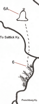
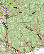
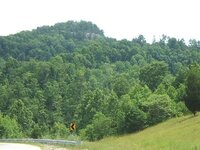
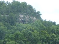
In Menifee County. Looks more like a bell when the leaves are off. Hard to tell by the images but this is a rounded cliff face. Going southwest on the blue lines takes you into Suiters Branch. If you rotate the topo map just slightly counter clockwise (or rotate the Swift Map clockwise), it looks like a match. I think the dashed lines on Swifts map could show a trail to the bell. The tree drawings could mean a rough road, thick with brush and/or trees and you must go on foot from this point? Heck, I don't know...just throwing something out there......
 

Attachments

  • Abell.PNG
    Abell.PNG
    23.4 KB · Views: 332
  • Abell topo.PNG
    Abell topo.PNG
    110.7 KB · Views: 339
  • DSCF3536.JPG
    DSCF3536.JPG
    99.9 KB · Views: 332
  • DSCF3539.JPG
    DSCF3539.JPG
    59 KB · Views: 336
Last edited:

hammer859

Tenderfoot
Aug 8, 2014
9
10
kentuck
Primary Interest:
Other
It all comes back to the useless map, I mean some places may look like it but it's in the wrong spot. I have been all over this area but it doesn't mean it's not there and people will make their own markings just to confuse.
 

OP
OP
1320

1320

Silver Member
Dec 10, 2004
3,434
2,308
East Central Kentucky
It all comes back to the useless map, I mean some places may look like it but it's in the wrong spot. I have been all over this area but it doesn't mean it's not there and people will make their own markings just to confuse.

I've seen another version of this map without the added markings and it's still Greek to me. My interest rests in the fact that it does have an uncanny resemblance to Menifee County, more or less if you look at just the drains, creeks and river. I have compared two versions of this map and yes, I see that some of the waterways are altered but, I can't tell you which map is which. Since I saw this one first, my brain wants to say that any other map that I see that is different makes this one the altered one when in fact, this one could be the right one and the other one has been altered...lol. For all I know, this map might look like 50 other counties, I have no idea, that's why I questioned the map in the other thread.

I also realize that this map has the other features added and I've always thought that this version was someone's "work in progress"....the things added were simply someone's discoveries transposed onto the map....to help see a bigger picture, not to fool me or anyone else. I don't take this stuff very seriously but it's good mental health. Thanks for your replies....keep them coming.
 

KY Hiker

Bronze Member
Oct 28, 2014
1,537
3,220
North Central Kentucky
Detector(s) used
Whites
Primary Interest:
All Treasure Hunting
I see that bell on that map and the first thing I think of is the ohhmm dome near Indian staircase and Cloudsplitter in the RRGorge. Once you get up inside it any loud noise rings like a bell in there. Sorry just my $0.02 worth, but visually trying to make a rock structure look like something else in your mind is self trickery. Its like seeing faces in clouds ect. There are probably 15 places in the gorge you can see a profile of a human in if you look from the proper angle. Our minds will always try to make something that looks unfamiliar into something that looks familiar. Examples like Chimney Rock, Half Moon rock and Courthouse Rock only resemble those things that they are named after. Move 90 degrees to another face of those rocks and they no longer fit their names! I guess what I am saying is it is rather easy to take what you see at face value only, its a trap we all can fall into. If that map is authentic then those symbols only meant something to the person who made it. It would be purposely made to not make sense to those that did not understand the symbols used. A map with detail but no key, no scale, or no indication of North is nothing more than a drawing. To assume North is up on a hand drawn map just because you can read the writing on it that way is probably a mistake.
 

OP
OP
1320

1320

Silver Member
Dec 10, 2004
3,434
2,308
East Central Kentucky
I see that bell on that map and the first thing I think of is the ohhmm dome near Indian staircase and Cloudsplitter in the RRGorge. Once you get up inside it any loud noise rings like a bell in there. Sorry just my $0.02 worth, but visually trying to make a rock structure look like something else in your mind is self trickery. Its like seeing faces in clouds ect. There are probably 15 places in the gorge you can see a profile of a human in if you look from the proper angle. Our minds will always try to make something that looks unfamiliar into something that looks familiar. Examples like Chimney Rock, Half Moon rock and Courthouse Rock only resemble those things that they are named after. Move 90 degrees to another face of those rocks and they no longer fit their names! I guess what I am saying is it is rather easy to take what you see at face value only, its a trap we all can fall into. If that map is authentic then those symbols only meant something to the person who made it. It would be purposely made to not make sense to those that did not understand the symbols used. A map with detail but no key, no scale, or no indication of North is nothing more than a drawing. To assume North is up on a hand drawn map just because you can read the writing on it that way is probably a mistake.

You make some excellent points, nice post. For what it's worth, I don't see a "bell" when I look at this cliff face, that's why I titled this post as "possible bell". I merely matched a geographic feature to a map that reportedly represents Menifee County. If the map is in fact Menifee County then the pictured cliff face is in close proximity to the bell as shown on the map. If you can find some of my other posts regarding this map you'll find that I once said "this map makes more sense when I turn it upside down"....lol. To make it a "fit" for Menifee, it does have to be rotated slightly clockwise. Key, scale, indication of North....I wouldn't expect to find any of these on a treasure map. You may also find that one of my earlier posts pretty much says that this map is useless...I mean, no one really knows where it came from!
 

O

Old Silver

Guest
The bell shape is connected to the vegetation by dotted lines. It could be a walking path, but what if the bell is meant as a blow up of the vegetation area. Maybe the vegetation is plants with bell shaped flowers (stem on top). Maybe it's a smaller hill, or cave, in the vegetation area.
 

OP
OP
1320

1320

Silver Member
Dec 10, 2004
3,434
2,308
East Central Kentucky
The bell shape is connected to the vegetation by dotted lines. It could be a walking path, but what if the bell is meant as a blow up of the vegetation area. Maybe the vegetation is plants with bell shaped flowers (stem on top). Maybe it's a smaller hill, or cave, in the vegetation area.

Very good points!
 

rgb1

Sr. Member
Nov 24, 2013
295
769
s.w. Ohio
Detector(s) used
2 whites 1 garett
Primary Interest:
All Treasure Hunting
you all have good points and i would acknowledge them as good however this map actually matches location of the mines i found this also matches directions given in the journal , as for the symbles on the map the ones i recognize match also rgb1
 

KY Hiker

Bronze Member
Oct 28, 2014
1,537
3,220
North Central Kentucky
Detector(s) used
Whites
Primary Interest:
All Treasure Hunting
Any place along a stream that has a 180 degree or more bend in it would look or have a bell shape to it if you stood on the opposite side of the stream from the bend and could see both sides of the opposing ridge.
Here is a popular place in the Red River Gorge for example:

https://i.ytimg.com/vi/09LH9RndRZk/maxresdefault.jpg
 

Last edited:
OP
OP
1320

1320

Silver Member
Dec 10, 2004
3,434
2,308
East Central Kentucky
I assumed it to be a bell because of the "legend" on that map. It could be a stirrup, a coat hanger, a hat. The more I viewed it, the more it doesn't look like a bell...lol
 

Rookster

Gold Member
Nov 24, 2013
29,382
111,597
Detector(s) used
XP Deus, F75Ltd., AT PRO, Garrett pointer
Primary Interest:
Cache Hunting
Always carry a compus when hiking.:laughing7:
 

KY Hiker

Bronze Member
Oct 28, 2014
1,537
3,220
North Central Kentucky
Detector(s) used
Whites
Primary Interest:
All Treasure Hunting
I assumed it to be a bell because of the "legend" on that map. It could be a stirrup, a coat hanger, a hat. The more I viewed it, the more it doesn't look like a bell...lol

The drawing on the map or the ridge you have pictured? :dontknow:
 

bearduke

Greenie
Sep 16, 2013
13
18
Anyone ever wonder why Hogs Branch is not shown on the map, but the dots represent the rock outcropping as you go up the branch?
 

OP
OP
1320

1320

Silver Member
Dec 10, 2004
3,434
2,308
East Central Kentucky
The bell shape is connected to the vegetation by dotted lines. It could be a walking path, but what if the bell is meant as a blow up of the vegetation area. Maybe the vegetation is plants with bell shaped flowers (stem on top). Maybe it's a smaller hill, or cave, in the vegetation area.

Myrtle Thicket? Hmmmmm
 

OP
OP
1320

1320

Silver Member
Dec 10, 2004
3,434
2,308
East Central Kentucky
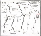
Credit to Boomer, this is copy/past of his older post.

1. Anchor: this is out of place, i feel this may be the key. the anchor is used to hold something. but what?
1A. Three creeks come together. the west branch is shaped like the
anchor with two drains like the cross bars. the chain or rope eye
is where the tea kettle rock is.

2. Waterfall: Broken leg falls next to RT. 460. there are two other
journals that have different story lines, but they say that bars,
coins and money molds are hidden near a falls.

3. Wagon Wheel: as we go along RT. 460 on the left is where a sink
is, shaped like an upside down cone.

4. Turkey Tracks: There are 3 creeks that come up from the red river
with three forks each.

5. Caves/Indian Mounds: there are 4 mounds on McCausey ridge or
whats left, 4 small humps. kept walking to many people around.
the caves are on the upper east fork of indian creek. there are
several close together. indian creek comes up from the red river
and was a trail used for hundreds of years. there is one small
section near the end of east fork that you can still find, if its winter.
it is almost 2 to 3 feet deep and just wide enough for a horse to
pass.

6. Bell: just pass the RT. 36 salt-lick turn off on Rt. 1274, second
hollow, suiters branch near end on right, top of ridge. bell shaped
rock. i did not go to top of ridge. but there is a reason for this bell?
6A. look at google earth, you can see the outcrop. i wonder how
they found this. its the middle of nowhere?

7. Halfway Branch: this is an odd one, the branch is to short. this
may mean to go to the end of the branch and go over to a
large hill just to the northwest of the left branch. on the south side
of this hill there is a rockhouse. X may mean this. never got to go
there. i did see a vary old path going up the creek. topo map
showed most of this.

8 and 9. Layers of Limestone: to the right of halfway branch is a drain
that runs straight to a cliff face that is layers of limestone. look at
number 9 and notice that the road runs straight and is long, than
bends to the right. on a good topo map, you can see the drain
runs straight and up on the right is a large rockhouse. this fits.
never did get to go to this rockhouse.

10. 7 Dots: this one is anyone's guess. between clifton creek and
hogshead branch is a narrow ridge that runs north/south and has
small knobs on top. than again it maybe hogshead branch, it
runs straight than bends to the right. there were ancient indians
living on beaver creek and one of their snake mounds is on
clifton creek. they used round rocks for the body. i wonder if this
could be what was seen. the rocks were rolled over the cliff from
above. i saw one pile of those rocks near hogshead branch on
the flats.

11. Needle Eye Rock: this i put on map because there has been talk
about it. its between long branch and main beaver creek. it looks
like a needle stuck in the ground. on topo map its called a natural
arch. someone destroyed a carving that was on floor of needle.

12. X : the location is between meyers fork and ratliff creek on
beaver. the bottom land has changed so much. i have no
idea. unless they where meaning, go up against the ridge or
maybe the caves?

13. Half moon Shaped Ridge: had no other name for it. ridge vary
high. ridge line vary long and narrow on south-side, just like the
drawing. there are caves near top.

14. Long Arrow: it means long way to go. search for arrow.

15. Star: long arm points north. there is a hill that has 5 arms. never went on top.
 

16. X: in april 1793, indians captured 19 women and children of Morgans station.
killed all in cave there. now called murder branch.

17. Some call it a ladder or British flag: The odd thing here is cold cave branch is not shown.
there are 7 drains that flow into cold cave branch, the last 4 or crossed out. the two lines
may be the stream bed with the X crossing at a spot on it. notice the two lines stop at the
last line, may be a cave at the end of the creek sealed over. but what ever, the last four or
crossed out. longbow boat dock is across from cold cave branch.

Spaws creek in red: money molds and mining tools were found there. gold coins were found at
mouth of same,

ORO in red: at the end of ratliff creek, there is a slanted rock with the the word oro and a faded cross
pointing northwest. i wonder if this has anything to do with number 7?

below number 13 are 4 sevens. this area is all farm land now. no idea?
 

Attachments

  • Mapofwhat.JPG
    Mapofwhat.JPG
    92.4 KB · Views: 166

Top Member Reactions

Users who are viewing this thread

Latest Discussions

Top